Air conditioning as a positive climate feedback?

A post by Chris RowanIt’s pretty hot here in Chicago right now, and the forecast says we’re going to spend most of the next week sweltering. It’s apparently shaping up to be the hottest June in a quarter of a century.

Forecast for Chicago on Weather Underground this morning. for the not metric people, 38 C is about 100 F.

In the face of these temperatures, I have to admit that I’m glad I can retreat to my cool, air conditioned office for some relief. It is a rather guilty relief, though, since I’m aware that a lot of energy goes into cooling my department so far below the outside temperature. Of course, I come from a country where air conditioning is relatively rare, especially in a domestic setting. A quick look at the current weather conditions in my homeland should give you a clue as to why; the UK has a summer barely worthy of the name more often than not, and even in a “good” one you might only feel the need for some artificial cooling a handful of weeks in a year, which hardly make the economics of buying and installing an air conditioner compelling. It is a definite luxury. The US is a different story: there are swathes of the south and central US where it would be difficult to function if you were left totally at the mercy of the ambient summer temperatures; US cities like Las Vegas and Orlando were built with the assumption that houses would be air conditioned as surely as they were built on the assumption that every family would own a car – for better or for worse, in both cases.

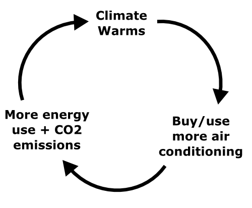
So I can acknowledge that air conditioning is more useful and important in the US, even if I still balk at the notion that it’s some sort of right (the Twitter hashtag #firstworldproblems would appear to be appropriate for that one). But the issue of the environmental cost of keeping ourselves comfortable still troubles me; and in a summer that seems to be delighting in breaking temperature records left, right and centre, I found myself contemplating the paradox that through our increasing greenhouse gas emissions, we might be increasing our demand for air conditioning – and part of those greenhouse gas emissions are the result of the operation of air conditioners. Could this be an example of a positive feedback loop?

A positive feedback loop where our need to cool ourselves increases our need to cool ourselves.

Positive feedback loops are often talked about in relation to global warming. There’s the ice-albedo feedback, whereby melting ice exposes land (or in the Arctic, sea) that absorbs rather than reflects solar radiation and drives more melting. There’s also the worrying notion that warming in the polar regions will destabilise gas hydrates and release large amounts of methane into the atmosphere, which will further accelerate warming. But these feedbacks are all entirely due to natural systems responding to our perturbation of the atmosphere, whereas this would be a positive feedback to global warming within our own civilisation: the increasing temperatures could be altering our behaviour in a way that will further warm the climate. It’s an interesting notion; the big question in my mind is the parallel effect of increased winter temperatures reducing the amount of energy we use for heating, which could entirely cancel out the increased summer energy use.

I’m also wondering if there might be other potential examples of civilisational feedback loops. One other possibility I’ve been considering is the relationship between agriculture, population growth, and soil degradation: more agriculture (and soil usage) supports faster population growth, that demands more agriculture. But that is complicated by the notion of carrying capacity – there is only a finite amount of land you can farm, and this would put a brake on a runaway feedback effect. Any other suggestions? Some possible negative civilisation-driven feedbacks would also be nice, if only to make us feel a bit better about ourselves.

Categories: climate science, environment, society

Avulsion: Anne’s new adventure

A post by Anne JeffersonMost of the time, nothing much interesting happens to a river. It flows between its banks, carrying water and solutes, providing habitat and ecosystem services. If you look at a river, most of the time it looks roughly the same – water levels go up and down, and the riparian vegetation goes through seasonal cycles, but your view of the river is still substantially the same scene.

Sometimes, a few days or weeks per year, the river floods. Water escapes the channel confines and inundates the floodplain. Sediments and wood move in the channel, sand and gravel bars rearrange, and banks erode. Viewing the river during a flood can be exciting, even dangerous, and it can look wildly different than its normal, low-water conditions. But, when the flood recedes, the channel geometry may look a bit different, but you can still tell that you are looking at the same spot, on the same river, that you viewed before the flood.

Academic careers are a bit like rivers. Most of the time, we spend our days carrying water and solutes, teaching students, collecting and analyzing data, writing grants and papers. If you looked in my office door on almost any day, you’d see me working at a computer, surrounded by stacks of papers and a cup of tea. Sometimes, though, things get a bit more exciting. I get to enjoy floods a paper being accepted, a new grant being funded, or a student graduating. On those days, you might find me joyfully chatting with a colleague or partaking in a celebratory lunch. Those flood days give me opportunities to explore new research directions or share new data and ideas, but they quickly recede back to baseflow, the enjoyable tedium of day-to-day work.

Every once in a while, however, something comes along that knocks a river off its old course, into an entirely new channel that strikes off across a previously undissected piece of the landscape. When this happens, geomorphologists call the event an avulsion. After an avulsion, you would see an entirely different scene from your favorite viewing spot. The old channel would be dry or filled with stagnant pools, and a new channel would be carrying the river’s water, sediment, and solutes across the landscape. Over time, a riparian community would grow up along this new channel, your favorite viewing spot would shift, and you might start to forget that the river didn’t always flow in the same spot.

So too, the academic career can have avulsions. And I am in the midst of one right now. After five years at UNC Charlotte, I have packed my office and lab, said goodbye to dear colleagues and students, and set off on a new adventure. There wasn’t anything wrong with my old channel position, but the opportunity arose for a new course through the academic landscape, and I am tremendously excited by the change of scenery.

Black squirrel with rock hammer, the Kent State Geological Society logoBeginning in August, I’ll be on the faculty of the Department of Geology at Kent State University in northeastern Ohio. I’m joining a group of 18 welcoming colleagues, ~30 dedicated graduate students in our MS and PhD programs, and over 100 enthusiastic undergraduate geology majors. I’m also part of a cluster hire established around the idea of urban ecosystems, so I’m looking forward to working with collaborators around the Kent campus and at the Cleveland Urban Design Collaborative. It’s an exciting time to be an urban hydrologist moving to northeastern Ohio, as the Cleveland area sewer district is in the midst of $3 billion of work to the sewer and storm water infrastructure, and is paying quite a bit of attention to green design and possibilities for neighborhood revitalization. I’m planning to focus on developing projects around increasing process-based, interdisciplinary understanding of streams and groundwater in urban environments, but I’ll also keep finding interesting questions beyond the city limits. I’m going to be developing some new classes and revitalizing some old ones, and I’ll stay active with professional service. So basically, after the avulsion, I’ll go back to carrying water and solutes, just in different scenery. But I’m looking forward to sharing the new views with all of you.

Cuyahoga River in Kent, Ohio

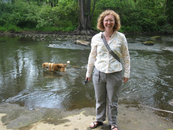
Anne and field assistant Cleo, doing reconnaissance field work in the Cuyahoga River at Kent, June 2012

Categories: academic life, by Anne

Stuff we linked to on Twitter last week

A post by Chris RowanA post by Anne JeffersonAfter a long hiatus, our weekly link-sharing extravaganza returns! Comprising the most interesting and notable things we have found around the internet in the last few days.

Other posts on All-geo

Volcanoes

Earthquakes

(Paleo)climate

Water

Duluth and Northern Minnesota Flooding

Environmental

General Geology

Interesting Miscellaney

Categories: links

Scenic Saturday: 101 Geo-sites

A post by Anne Jefferson

Following the lead set by Callan Bentley, the list of “101 American Geo-sites you’ve gotta see” (as published in a new book by Albert Dickas) has been circulating the geoblogosphere. While it seems a bit exclusionary to our non-USian geo-colleagues, I couldn’t resist the chance to look through the list and see which sites I’ve visited. Those to which I’ve been (however vague my childhood memories of the geology), are listed in bold.

1. Wetumpka Crater, Alabama
2. Exit Glacier, Alaska
3. Antelope Canyon, Arizona
4. Meteor Crater, Arizona
5. Monument Valley, Arizona
6. Prairie Creek Pipe, Arkansas
7. Wallace Creek, California
8. Racetrack Playa, California
9. Devils Postpile, California
10. Rancho La Brea, California

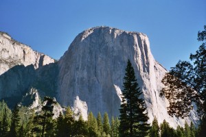
El Capitan, Yosemite, photo by A. Jefferson, September 2004

#11. El Capitan in Yosemite National Park, California. Photo by A. Jefferson.

11. El Capitan, California – In 2004

12. Boulder Flatirons, Colorado – Not yet, but I’ll be in Boulder next month for a conference and I’ll make sure to see them then.

13. Interstate 70 Roadcut, Colorado – at least once, sometime in the early 1990s.
14. Florissant Fossil Beds, Colorado – Again, in the early the early 1990s.

15. Dinosaur Trackway, Connecticut
16. Wilmington Blue Rocks, Delaware
17. Devil’s Millhopper, Florida
18. Stone Mountain, Georgia
19. Kilauea Volcano, Hawaii
20. Borah Peak, Idaho
21. Menan Buttes, Idaho
22. Great Rift, Idaho
23. Valmeyer Anticline, Illinois
24. Hanging Rock Klint, Indiana
25. Fort Dodge Gypsum, Iowa
26. Monument Rocks, Kansas
27. Ohio Black Shale, Kentucky

28. Mammoth Cave, Kentucky – Spring 2011. I blogged about in December 2011.

29. Four Corners Roadcut, Kentucky
30. Avery Island, Louisiana
31. Schoodic Point, Maine – Not there exactly, but spent a summer on Mt Desert Island in 1998.

32. Calvert Cliffs, Maryland – Yes, in the summer of 1999.
33. Purgatory Chasm, Massachusetts
34. Nonesuch Potholes, Michigan – As a child, and verified by my mother that we indeed walked along the stream and saw the potholes. I remember the Porcupine Mountains Wilderness State Park as utterly wild and beautiful.
35. Quincy Mine, Michigan – On the same trip as above. We didn’t go underground, because we missed the last tour of the day, but we did see the workings from the surface.

36. Grand River Ledges, Michigan
37. Sioux Quartzite, Minnesota – I’ve driven across it on I-90, but not stopped to go to Pipestone. I’ve spent more time in the area of the Morton gneiss, which is older.
38. Thomson Dikes, Minnesota

39. Soudan Mine, Minnesota – Yes, twice as a child.

40. Petrified Forest, Mississippi
41. Elephant Rocks, Missouri
42. Grassy Mountain Nonconformity, Missouri
43. Chief Mountain, Montana

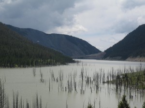
Madison slide as viewed from upstream on Quake Lake. Photo by A Jefferson, June 2010.

#44. Madison slide as viewed from upstream on Quake Lake, Montana. Photo by A. Jefferson.

44. Madison Slide, Montana – In 2010.

45. Butte Pluton, Montana
46. Quad Creek Quartzite, Montana
47. Ashfall Fossil Beds, Nebraska
48. Scotts Bluff, Nebraska
49. Crow Creek Marlstone, Nebraska
50. Sand Mountain, Nevada
51. Great Unconformity, Nevada
52. Flume Gorge, New Hampshire
53. Palisades Sill, New Jersey

54. White Sands, New Mexico – Yes, in about 1991.
55. Carlsbad Caverns, New Mexico – On the same trip as above, in about 1991.

56. Shiprock Peak, New Mexico
57. State Line Outcrop, New Mexico

58. American Falls, New York – In 1995.

59. Taconic Unconformity, New York
60. Gilboa Forest, New York

61. Pilot Mountain, North Carolina – In May 2009, and I blogged about in September 2011.

62. South Killdeer Mountain, North Dakota
63. Hueston Woods, Ohio
64. Big Rock, Ohio
65. Kelleys Island, Ohio
66. Interstate 35 Roadcut, Oklahoma

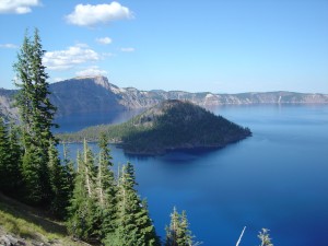
Crater Lake and Wizard Island in the remnants of Mt. Mazama, Oregon. Photo by A. Jefferson, 2005.

#67. Crater Lake and Wizard Island in the remnants of Mt. Mazama, Oregon. Photo by A. Jefferson.

67. Mount Mazama, Oregon – In 2004 and 2005.
68. Lava River Cave, Oregon – Yes, in 2002, but I lack photos.

69. Drake’s Folly, Pennsylvania
70. Hickory Run, Pennsylvania
71. Delaware Water Gap, Pennsylvania
72. Beavertail Point, Rhode Island
73. Crowburg Basin, South Carolina

74. Mount Rushmore, South Dakota – Twice, before the advent of digital photography.
75. Mammoth Site, South Dakota – In the early 1990s.
76. Pinnacles Overlook, South Dakota – In the early 1990s.

77. Reelfoot Scarp, Tennessee
78. Enchanted Rock, Texas

79. Capitan Reef, Texas – In 1991, on the same trip as Carlsbad Caverns and White Sands.

80. Paluxy River Tracks, Texas
81. Upheaval Dome, Utah
82. Checkerboard Mesa, Utah
83. San Juan Goosenecks, Utah
84. Salina Canyon Unconformity, Utah
85. Bingham Stock, Utah
86. Whipstock Hill, Vermont
87. Great Falls, Virginia
88. Natural Bridge, Virginia
89. Millbrig Ashfall, Virginia

Hydrophiles at our Toutle River put-in, April 2004.

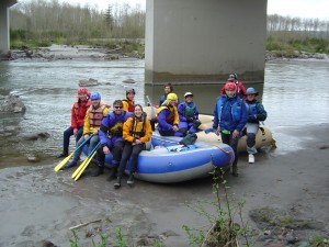
91. The OSU Hydrophiles embarking on a Toutle River raft trip, downslope from Mt. St. Helens and in the path of the lahars. Evidence of the eruption was clear all along the river.

90. Catoctin Greenstone, Virginia – Though at Catoctin Mountain Parkin Maryland in 2000.
91. Mount St. Helens, Washington – In 2003 and 2004.
92. Dry Falls, Washington – In 2005, blogged in June 2009.
93. Seneca Rocks, West Virginia – In 1997. This is where I had my first rock climbing experience.

94. Roche-A-Cri Mound, Wisconsin
95. Van Hise Rock, Wisconsin

96. Amnicon Falls, Wisconsin – Several times in the 1980s and 1990s.

97. Green River, Wyoming

98. Devils Tower, Wyoming – In 2002.

99. Fossil Butte, Wyoming

Steamboat Geyser, Yellowstone National Park. Photo by C Rowan, June 2010.

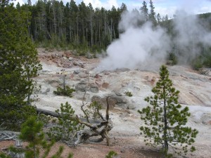
#100. Steamboat Geyser, Norris Geyser Basin, Yellowstone National Park, Wyoming. Photo by C. Rowan.

100. Steamboat Geyser, Wyoming – In 2010.

101. Specimen Ridge, Wyoming

A couple things have become clear to me in going through this list: The period of digital photography is quite short relative to even my 3.3 decades of travels. I’m incredibly grateful for all of the traveling I did with my Mom and Dad as a kid. There’s still so much to see! I’m looking forward to more geo-travels in this country and abroad in the months and years to come.

Categories: by Anne, outcrops, photos

Friday Focal Mechanisms: South Australian shaking keeps Chris guessing

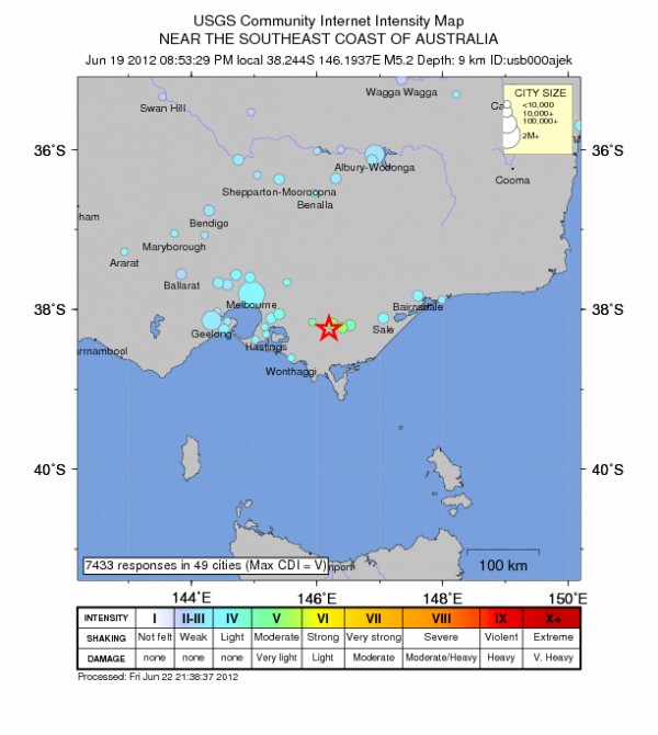
A post by Chris RowanRather annoyingly, I’ve actually been unable to find a focal mechanism for the magnitude 5.2 earthquake that shook the state of Victoria in southeast Australia on Tuesday. Although there were no reports of major damage, the relatively shallow depth of the rupture meant that people over a wide area felt the shaking, including a friend of mine who lives in Melbourne.
[blackbirdpie url=”http://twitter.com/syntype/status/215434334683926528″]

Source: USGS

What makes things even more tricky is the fact that this was an interplate earthquake, occurring far from any active plate boundary. Rather than being caused by deformation between two tectonic plates that are moving around the planet at different speeds and in different directions to each other, it was the result of deformation within the Australian plate itself. When an earthquake occurs at or near a plate boundary, since we know how the two plates are moving relative to each other, we can at least make a reasonable guess as to whether it is caused by compression or extension, and even what direction that compression or extension is occurring in. In contrast, interplate earthquakes are driven by forces that are more distant, and more subtle, and happen on old, reactivated faults that were formed in a tectonic episode that is now long finished. All this makes it hard to make even a marginally educated guess as to what sort of focal mechanism we might expect.

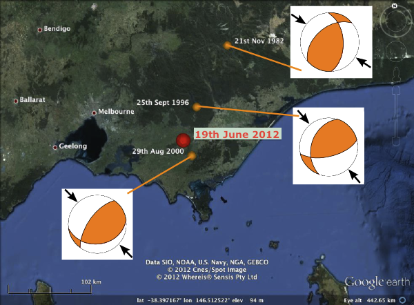
Fortunately, earthquakes also rarely occur in complete isolation, and I managed to dig up this report from Geoscience Australia that lists all known Australian earthquakes for which focal mechanisms have been determined (the fact that you can actually do this without producing a telephone directory tells you something about how seismically active Australia…isn’t). This list contained three moderately large (body wave magnitudes of 4.7-5.0) earthquakes in the same area as Tuesday’s event, which I’ve plotted together with their listed focal mechanisms in the figure below:

Locations and focal mechanisms of significant earthquakes in Victoria in the past 20 years (orange dots), compared to location of the M 5.2 earthquake on 19th June 2012 (red dot)

As you can see, these focal mechanisms (as well as two smaller aftershocks of the August 2000 event, which I didn’t plot) rather consistently show northwest-southeast compression on northeast-southwest oriented faults. This consistency suggests there might be a uniform regional stress field acting on the crust in this region – and that there are a number of old faults with similar (NE-SW) trends being reactivated in response to this stress. Based on this, suggesting that Tuesday’s earthquake was similar to these other three seems like a reasonable hypothesis. And whilst we’re guessing, I’d guess the dominance of northeast-southwest trending faults in this area may be due to it being at the southern end of the Great Dividing Range, a series of mountain belts that runs along the entire east coast of Australia; their formation would have produced lots of thrust faults in this orientation.

Of course, I could easily be wrong; if and when someone produces a focal mechanism, I’ll let you know.

Categories: earthquakes, focal mechanisms, tectonics