Thanks for giving kids the Earth (Science)

A post by Anne JeffersonIn October, we happily took part in the DonorsChoose Social Media Challenge, teaming up with All of My Faults are Stress-Related and Eruptions to create a geoblog generosity trifecta. We got amazing results, with geoblogs readers giving $8660 to our challenge.
Part of that money was contributed by a generous match from HP, and they have distributed giving codes to all challenge donors. If you gave to a DonorsChoose challenge in October, check your email for a link to put that HP match into action. All you have to do is follow the link, select the project(s) of your choice, and spend HP’s money.
Chris, Kim, and I also promised you that we would write 5 posts of you choice, but so far we’ve only gotten suggestions from three people. Suggest away and give us some inspiration to post here.
Finally, I wanted to share with you the most wonderful thanks I’ve gotten for contributing to the challenge. Donors who give $100 to a single project, or contribute the amount needed to fully fund the project, get a packet of thank you letters from the students. I helped complete a project that gave copies of Seymour Simon’s book Mountains to a classroom in Utah. Here are a sampling of the thank you letters I received:
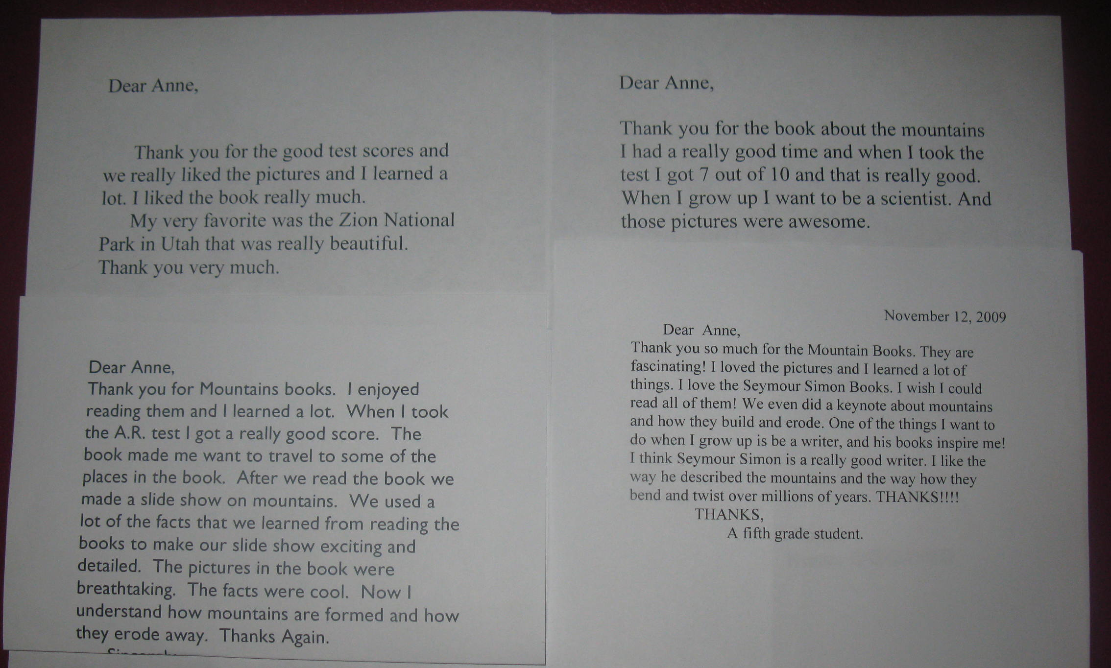
dc-thanks.jpg
(Click to enlarge.)

Categories: science education

Casting a Wider Net: Opportunities for Enhancing Diversity in the Geosciences

A post by Anne JeffersonAlong with D.N. Lee, I’ll be convening a session on Casting a wider net: Promoting gender and ethnic diversity in STEM at Science Online 2010. To start discussion going in preparation for the session, DNL is hosting the next edition of the Diversity in Science carnival, with a theme of “STEM Diversity and Broad Impacts I: Highlights of successful, ambitious STEM diversity programs such as REUs, mentoring programs and scholarships for college under-graduates, graduate students, post-doctoral associates and early career scientists and engineers.” The deadline for submissions is today, and the carnival will go up on Friday.
In the United States, we have a diversity problem in the geosciences. Less than 5% of BS degrees in geosciences go to minorities, contrasting with ~15% in science and engineering as a whole (NSF data from 2000). As we move into graduate school the problem remains: 3.3% at the M.S. level and 5% at the PhD level. For the sciences and engineering combined, it’s 10.6% for the MS and 8.2% for the PhD. Contrast this with the demographics of the American population, and you see that the sciences in general, and geosciences in particular, are not doing a good job of attracting students that reflect the diversity of our country and are losing out on the discoveries a more diverse scientific community might be able to produce.
NSF has recognized this near-monoculture in geosciences as a problem, and specifically solicits ideas and programs that might improve the situation through its Opportunities for Enhancing Diversity in the Geosciences (OEDG) program. Here’s the gist of the program synopsis:

“The primary goal of the OEDG Program is to increase participation in the geosciences by African Americans, Hispanic Americans, Native Americans (American Indians and Alaskan Natives), Native Pacific Islanders (Polynesians or Micronesians), and persons with disabilities. A secondary goal of the program is to increase the perceived relevance of the geosciences among broad and diverse segments of the population. The OEDG Program supports activities that will increase the number of members of underrepresented groups who:
* Are involved in formal pre-college geoscience education programs;
* Pursue bachelor, master, and doctoral degrees in the geosciences;
* Enter geoscience careers; and
* Participate in informal geoscience education programs.”

The program offers three tracks for funding: planning grants (getting our act together to roll out a new program); proof-of-concept projects (one-time and short-term activities); and full-scale projects (5 years of funding and designed to be self-sustained after the end of the grant period).
The array of projects that have been funded by the OEDG program is inspiring.

  • Morgan State University in Baltimore, Maryland is helping high school students and their teachers connect to the geosciences by giving them hands-on field experiences in Chesapeake Bay in a proof-of-concept OEDG grant.
  • Faculty at North Carolina A&T State University, Penn State University, Fort Valley State University, University of Texas El Paso, and California State University Northridge are developing AfricaArray, an alliance that will run summer workshops for high school teachers, create scholarships and high school outreach activities, conduct a summer field course in Africa to recruit and mentor undergraduate students, and provide opportunities for students to participate in research in Africa, in a full-scale project through OEDG.
  • The Hawaii Institute of Marine Biology is creating Ocean FEST (families exploring science together) to reach out to elementary-school Native Hawaiians and Pacific Islanders and their families by creating an evening program to engage them with ocean-environment issues and demonstrate the value of geoscience careers to the local community, in a proof-of-concept grant.
  • Lake Superior State University in northern Michigan is creating a two-week summer geoscience field experience targeting Native-American high school students, by engaging them in solving geological problems with faculty, taking them to sites of both geological and Native American significance, and linking ways of scientific thinking and ways of knowing from within their own cultures.

The projects listed above are just a sampling of the sort of programs that OEDG funds. My university serves ~25% minority students, but our upper-level geoscience classrooms are significantly whiter. In my third year at Charlotte, I am still trying to develop my sense of how to get my classrooms to be more reflective of the university’s student body and the wider community. How can I cast a wider net?
I am starting to think down the line toward an OEDG proposal aimed at giving urban, minority university students a field geoscience experience and then maybe having them partner with high school students to do geoscience research projects in the local area. I’d be curious to know if any of our readers have experience doing this sort of project or if any of you might be interested in partnering on some future OEDG proposal.

Categories: academic life, by Anne, science education

The amazing disappearing asymmetric magnetic reversals

ResearchBlogging.orgA post by Chris RowanInterpreting the record of the Earth’s magnetic field preserved in rocks – palaeomagnetism – is a complicated business, but at the heart of it is one very simple assumption: except when it is reversing, if you average over a few thousand years or so, the geomagnetic field resembles a dipole aligned with the Earth’s geographic poles.

geomag.gif

This relatively uncomplicated shape means that there is a very simple relationship between latitude and the magnetic inclination (the angle magnetic field lines make with the horizontal); it is zero at the equator, and gradually increases to 90 degrees at the poles. If you measure the direction of the fossil field direction carried by rocks at a particular site, a simple formula converts the inclination of this ancient magnetisation into the palaeolatitude of that particular chunk of crust at the time the rocks formed. Because the field is symmetric, a reversal changes the polarity, but not the shape, of the field; for example, an inclination value of 50 and -50 degrees both always correspond to a latitude of 30 degrees.
Symmetric Geomagnetic Field - simple relationship between inclination and latitude
But what if our simple assumption is wrong, and the Earth’s magnetic field has not always been a dipole? There are more complicated quadropole and octopole components in the present geomagnetic field, but they are fairly minor and, except during a magnetic reversal, seem to average out to zero over a few thousand years. But what if at some point in the geological past these components were not only a more significant part of the geomagnetic field, but also did not average to zero over geological time? This would produce an asymmetric long-term field geometry, as in the figure below, where 15% of the earth’s magnetic field energy is in the quadropole component. For a point at mid-to low northern latitudes, rocks forming in a normal polarity field would have a shallow magnetic inclination, whilst rocks forming in a reversed polarity field would have a much steeper inclination. The warped field geometry means that there is no longer a one-to-one relationship between inclination and latitude, which makes working out the plate motions recorded by all of those ancient magnetic directions much more difficult.
Asymmetric field - no simple relationship between inclination and latitude

Continue reading

Categories: geology, geophysics, palaeomagic, past worlds, Proterozoic

Stuff I linked to on Twitter last week

A post by Chris RowanMore interesting links that I’ve shared via Twitter over the past seven days. If I had to highlight just one you should really click on, take some time to be wowed by the HiRISE imagery of Mars over at the Big Picture – they are jaw-droppingly beautiful. And seismogenic – also known as Julian from Harmonic Tremors – earned all the geonerd cred, and everyone’s insane jealously, by filming his encounters with Hawaiian lava.
Bill Bryson’s Notes from a Large Hadron Collider Manages to convey excitement without any destroy the Earth!! nonsense.
http://www.timesonline.co.uk/tol/news/science/eureka/article6899505.ece
Zuska explores cultural parallels between scientific and religious institutions.
http://scienceblogs.com/thusspakezuska/2009/11/can_we_talk_about_science_i_me.php
(via @ScienceBlogs )
35 beautiful landscapes selected from HiRISE imagery at The Big Picture. Coffee table book out when?
http://www.boston.com/bigpicture/2009/11/martian_landscapes.html
(via @HiRISE)
Philippines: Mayon ‘may explode anytime’, heavy rains mean lahar risk remains.
http://www.manilatimes.net/index.php/component/content/article/42-rokstories/5412-mount-mayon-may-explode-anytime–phivolcs-official
(via @volcanismblog)
Dr. Albert Bartlett’s "Laws of Sustainability".
http://www.theoildrum.com/node/5925
(via @TheOilDrum)
Geoengineering in the House. Of Congress, that is. Seems testimony was sensible, at least.
http://blogs.nature.com/news/thegreatbeyond/2009/11/geoengineering_in_the_house.html
(via @NatureNews)
Some beautiful images of islands from space. No. 10 us the coolest.
http://www.wired.com/wiredscience/2009/11/islands-space/
(via @geographile)
MESSENGER Rewrites Mercury Textbooks Even Before Entering Orbit: Lots of iron, but not in silicates…
http://www.planetary.org/news/2009/1105_MESSENGER_Rewrites_Mercury_Textbooks.html
(via @elakdawalla)
The World’s Costly Nitrogen Addiction: 80 megatons of fertiliser used/year; only 17 gets into food.
http://www.e360.yale.edu/content/feature.msp?id=2207
(via @YaleE360)
Unsettled Youth: Spitzer Observes a Chaotic Planetary System Dust cloud formed by lots of proto-planetary collisions?
http://www.physorg.com/news176576185.html
Another example of synthetic aperture radar data being used to track volcanism in the African Rift Valley.
http://www.sciencedaily.com/releases/2009/11/091104123027.htm
Solar power generation around the clock . Heat stored in molten salt -> electricity as needed.
http://www.physorg.com/news176632405.html
(via @physorg_com)
Haunting outlines of bones and plastic highlight impact of plastic on albatrosses.
http://www.guardian.co.uk/environment/gallery/2009/nov/03/albatross-plastic-poison-pacific
(via @BobOHara, @edyong209)
Blog post from @brianshiro about his work at Pacific Tsunami Warning Centre.
http://www.astronautforhire.com/2009/11/tsunami-kind-of-month.html
Not pretty at all: Athabasca Oil Sands: open-pit mines and tailings ponds line the Athabasca River.
http://earthobservatory.nasa.gov/IOTD/view.php?id=40997&src=iotdrss
(via @EarthObser)
Fibre optic solar cells.
http://news.bbc.co.uk/1/hi/sci/tech/8341186.stm
(via @suehutton)
Even if all other CO2 emissions stopped, fully exploiting Canada oil sands -> 2C global warming.
http://business.timesonline.co.uk/tol/business/industry_sectors/natural_resources/article6902006.ece
(via @twitoil)
CO2 from forest destruction overestimated.
http://www.guardian.co.uk/environment/2009/nov/03/forest-destruction-co2-overestimated
(via @guardianscience)
Video of lava flows on Kilauea from @seismogenic. Not jealous not jealous not jealous…
http://www.youtube.com/watch?v=Aqj_VGQUC8g ,http://www.youtube.com/watch?v=wnbcYtgDwCw
Run don’t walk to Cassini raw images site for new pics from Enceladus flyby e.g.
http://saturn.jpl.nasa.gov/photos/raw/?start=1 ,http://saturn.jpl.nasa.gov/multimedia/images/raw/casJPGFullS54/N00145397.jpg
(via @elakdawalla)
Nice discussion of the Shiva Crater palava by Suvrat.
http://suvratk.blogspot.com/2009/11/end-cretaceous-how-many-impacts-how.html
‘Ultra-primitive’ particles found in comet dust Including lots of ‘pre-solar’ grains.
http://www.physorg.com/news176400764.html
(via @physorg_com)
New PNAS study lists 17 easy household changes that would reduce US ems by 7%
http://www.pnas.org/content/early/2009/10/23/0908738106.abstract
(via @KHayhoe)
Atacama mudflows may be equivalent of controversial recent flow deposits on Mars.
http://www.abc.net.au/news/stories/2009/11/02/2730988.htm
(via @geologynews)
Geological Society of London on fossil webs found in amber: wow!
http://www.geolsoc.org.uk/gsl/geoscientist/geonews/fossilwebs
(via @geosociety)
Coping With Climate Change: Which Societies Will Do Best?
http://www.e360.yale.edu/content/feature.msp?id=2205
(via @YaleE360)
Solar power from Sahara a step closer CSP network aims to provide 15% of Euro power by 2050. Ambitious…
http://www.guardian.co.uk/business/2009/nov/01/solar-power-sahara-europe-desertec#
Planet hunt delayed by noise problems with Kepler. Fixable though.
http://www.nature.com/news/2009/091030/full/news.2009.1051.html
(via @NatureNews)

Categories: links

Earthquakes within plates: we don’t know when, and we may not know where

ResearchBlogging.orgA post by Chris RowanEd has already given the lowdown on a new study in Nature which might lead to a rethink on earthquake hazards in the continental interior. Plate tectonics treats plates as entirely rigid entities, but continental crust is too weak, and too riddled with faults left over from when it was close to a plate boundary, for it to entirely hold up when subjected to the stresses of plate motion. So although a very large proportion of the Earth’s earthquakes occur at plate boundaries, there is also some seismicity – including some very large shocks – within plate interiors. The problem is working out where this intraplate deformation is going to occur, and to do so seismologists rely on data which serve them well at plate boundaries – the historical record of large earthquakes, and the location of low-level seismic activity which indicates the build up of tectonic strain.

What Stein and Liu argue in their paper is that away from the plate boundaries, these tools provide a very misleading picture. In apparently active parts of the continental interior like the New Madrid area, all the abnormal seismicity can be regarded as a long-lived aftershock sequence; rather than indicating any new elastic strain being built up by external forces, which could eventually produce another large earthquake in the future, the seismicity is just a local tectonic response to a historically recent large earthquake (in New Madrid’s case, it was a series of magnitude 7-8 earthquakes in late 1811 and early 1812), and will eventually die off with time.

This conclusion is a little worrying, since it implies that the next big intra-continental quake might well occur in what presently seems to be a seismically inactive region, which, given the density of old faults cutting through your typical chunk of continental crust, could be almost anywhere. We already know the difficulties of predicting when big earthquakes are going to occur, but it seems that in the middle of plates, predicting where they are going to happen might also be a bit more tricky than we thought. However, a caveat remains: the proposed length of a typical intra-continental aftershock sequence is hundreds of years, which is much longer than our instrumental records, and even historical records in many places. The authors do point out that earthquake patterns in China, which has the best historical record, is of single large quakes in different areas (with last year’s Sichuan quake being the most recent) rather than a series of large earthquakes associated with a particular fault; perhaps palaeoseimology can show whether a similar pattern holds further back in time and on other continents.

Stein, S., & Liu, M. (2009). Long aftershock sequences within continents and implications for earthquake hazard assessment Nature, 462 (7269), 87-89 DOI: 10.1038/nature08502

Categories: earthquakes, geohazards, geology