
A new paper on the chronology of the last magnetic reversal concludes it took 20,000 yrs, and there were two distinct excursions – where the field becomes weak and disorganized, but it recovers without reversing polarity – before the main event about 773,000 yrs ago.
The paper combines magnetic records from igneous and sedimentary rocks, which have different strengths and weaknesses:
- Cooling volcanic lavas take accurate spot readings of the magnetic field, but you only get a reading when there is an eruption. Your spot readings are…spotty!
- Marine sediments can preserve an almost continuous record, but even at relatively high rates of deposition it is smeared out by bioturbation, so you are averaging the field direction over a 1000 years or more. That can average out a lot of variation, even in ‘normal times’!
The proposed duration of the reversal period is longer than most recent suggestions I’m seen (which are more of the order of 6000–10,000 years). The actual final reversal interval is more in line with this – it is just (in this account) preceded by a longer period of unrest.
See also the excellent write-up of this paper by Scott Johnson at Ars Technica. It is important to note that events like this are really pushing at the resolution limits of geological records, so getting a coherent and reliable picture is very tough.
The above study briefly discussed the fact that although the field during a reversal is non-dipolar, weak and disorganised, the places that rocks formed during these transitional periods think the magnetic poles is appear to fall in preferred longitudinal bands. Basically, the tiny rock magnets that record the field direction during reversals point more often than not point towards ‘north poles’ on arcs that run through the Americas and the W Pacific/Australia.
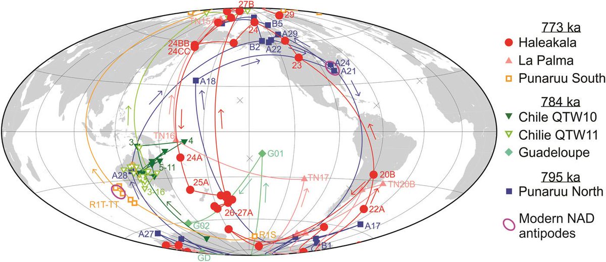
There is a lot of debate over whether this apparent preference exists at all, or is just a sampling artifact (remember, our recording medium – rocks – does not really have the resolving power to properly ‘see’ a reversal). If it does exist, there is also a lot of debate over the mechanism. Which brings me to another recent paper on this very subject, which rather blew my mind.
It reports high pressure experiments that indicate hematite in subducting slabs, formed from low temperature alteration of magnetite at the surface or decomposition of magnetite during subduction, might remain ferromagnetic (able to retain a strong remanent or permanent magnetisation) down to around 600 km depth.
So in places like the Western Pacific, where subduction has been going on for tens of millions of years, there might not just be a large slabs of cold rock hanging around in the upper mantle, but large magnetic slabs of cold rock. Currently, the magnetism of these subducted slabs is not particularly strong compared to the main (core) field of the Earth. But when that field is weak, where might your compass end up pointing? Maybe the big mass of magnetic rock in the upper mantle?
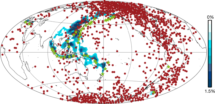
Although the authors focus on the Pacific, there are also significant subducted slabs beneath North America (the Farallon slab) and South America, which could play a similar role. Is this correct? Who knows at the moment? But it’s a truly intriguing idea that took my breath away when I read it.
[This post was collated from two twitter threads: here and here]