Ten million feet upon the stair

A post by Chris RowanDuring my time in Edinburgh, I lived in an apartment in a nice old tenement building: several floors of individual flats, all connected by an internal communal staircase. The building is at least a century old, and because this was back when things were built to last, each stair is a slab of gritty sandstone. But nowadays, each of those slabs is looking a little worn.

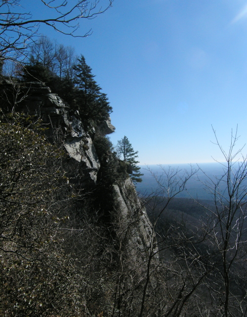
The stairs up to my Edinburgh flat. Photo: Chris Rowan, 2010.

This wear is the cumulative result of a century of people walking up and down from their flats. As they left for and returned from work, as they nipped out to the shops or ventured out for an evening in one of Edinburgh’s many pubs, many times a day the feet of the people who lived here would fall upon each stair. The force applied by each footfall may not be great, even for those who had over-indulged in deep-fried Mars bars. But as every geologist knows, even a small force, repeated over a large enough stretch of time, can add up to some very large effects indeed. And a brief (and very rough) calculation shows that a century’s worth of footsteps is quite a lot:

  • Assume 30 people living in the building at any one time (a very conservative assumption for 16 2-bedroom flats, especially since in the early 20th century this tenement probably a lot more crowded.
  • Assume each person travels up and down the staircase 4 times a day on average, thus stepping on each step 8 times a day. This comes to a total of 240 footsteps per step per day – factoring in visitors and postmen, lets say 260.
  • Multiplying up, this comes to 1800 footsteps per step per week, around 7000 a month, or almost 100,000 a year.
  • Therefore, if the building was just over a century old (which is a reasonable estimate for the area of Edinburgh I lived in, each step has been struck by at least 10 million feet since it was laid down.

When I climbed this staircase to my flat, I would often look at the uneven steps and ponder this visible sign that my home had a history, that I was merely the latest in a long line of people who had lived there, some before I, or even my grandparents, were born. Indeed, in a city like Edinburgh, feeling a bit parvenu is a common occurrence. But, perhaps unsurprisingly given my profession, I also enjoyed the daily reminder that humans are a geological force; not individually, perhaps, but through sheer weight of numbers. If each of those 10 million feet were attached to a person, and those 10 million people were all sent up this staircase in single file, it would take less than 8 months for them to collectively erode away a centimetre of sandstone. And that’s when they’re acting in series – passing up one by one. What if they could act in parallel; if, somehow, they could all step on the same stair at the same moment? Each of those 10 million light footsteps would add up to a sledgehammer blow that would, in an instant, turn that centimetre of rock to dust. And then, consider that 10 million people is but a small fraction of the almost 7 billion people currently in the world. If you could somehow harness the feet of all of those people at once, then you could grind 7 metres of rock away in the blink of an eye. A few more repetitions and you’d have an impressive ravine. Keep going for a few hours, and you could produce a new canyon.

All this might seem like a rather implausible thought experiment, and it is certainly rather impractical to have the entire population of the world planting their footprints on a single stair. But when it comes to our carbon footprints, the entire planet is the stair. Our individual contributions – the energy we expend, the waste we produce – may seem insignificant, hardly something that is going to affect the planet. But when you multiply it by 7 billion, the small environmental impact of any one person becomes a very weighty footstep indeed; and after more than a century of increasingly heavy footfalls, it’s not surprising that the Earth is as worn down as my old staircase.

Categories: deep time, environment, geomorphology

Earth Science Erratics: the kinder, gentler way to start geoblogging

A post by Chris RowanIf the crowd at the AGU science blogging workshop last month was anything to go by, then there are plenty of earth scientists out there who are tempted to try their hand at geoblogging; perhaps some have even decided to make it one of their New Years’ Resolutions. If so, it’s a resolution that I, for one, would like to see everyone keeping: although there are more geology blogs than ever before out there, we still only represent a tiny fraction of the wider earth science community, both within academia and especially without it, in industry and government. As far as I’m concerned, the more voices join the chorus, contributing their own unique knowledge and viewpoints, the better.

But I also know how difficult it is to get started. It’s easy to set up a blog, of course, but getting into the habit of writing regularly for it is much more difficult; especially right at the beginning, when you’re still trying to draw in and build up your audience – a task that is simultaneously easier, due to the rise of social media, and harder, as it becomes more difficult for a new geoblogger to get noticed in the crowd.

We want to encourage people both to get started, and more importantly, give them the support they need to get established. Thus, Earth Science Erratics was born.

As the introductory post explains:

Earth Science Erratics is conceived as a place for geoscientists or geosciences enthusiasts to be able to write one or a few blog posts, on any earth science topic of their choice, without the necessity of establishing their own blog. Think of this space as a field of erratics…

…We’d like to host an assortment of posts here – from the consulting geologist sharing tales of a field project in an exotic locale, to the grad student anxious to practice his science writing skills explaining a part of their discipline…from the amateur earth scientist who wants to write about the geology in her neighborhood to the researcher who wants to share her newly published results with an audience broader than journal readers.

Effectively, we’re providing a space for new bloggers to test the waters and develop their writing style – a space where we can guarantee you some page views, and feedback from the rest of the geoblogosphere. What we’re hoping is that contributors will catch the blogging bug, and head off with an appropriate fanfare to their own space (with a name that includes a suitable geo-pun, of course!). But there’s no pressure to post, and for those who only want to write a post or two, or only something every few months, it will be archived in a place that is easy for others to find.

So, if you’re tempted to dip your toes into the blogging waters, just drop us a line (or leave a comment below) and we’ll be happy to set you up with an account, and give you as much help and advice as you need.

Categories: bloggery

After the (blog)storm: following up on the big geological stories of 2010

A post by Chris RowanA post by Anne JeffersonIn the past year, there have been several occasions where we’ve discussed events that were, at the time of posting, capturing a lot of media attention. But, as we all know, the attention span of the rolling news cycle is finite, and often a great deal shorter than the running time of the stories that they initially blanket with coverage – especially when these stories involve natural disasters. But the story continues, and, to their credit, journalists do not give up on covering them.

As such, we though we’d end our blogging for the year with brief updates on some of the bigger stories we’ve blogged about in 2010.

Floods in Pakistan (August-present)

Unusually heavy monsoon rains this summer, led to a slow moving wave of flood water heading down the Indus River in Pakistan, flooding vast areas, and displacing 14 million people. By any measure, this was the most significant natural disaster of 2010 – and the fact that it occurred in Pakistan has massive implications for regional and international security. Yet it was significantly under-reported by the mainstream media, one of the reasons that donations to the international aid effort were much less than was needed. Even now, the floodwaters have not completely subsided, and more than 7 million people remain without a home to shelter from the oncoming winter.

The Haiti Earthquake (12th January)

Chris’s explanation the tectonic context of the magnitude 7.0 earthquake that struck Haiti in the early weeks of 2010 is by some distance the most-read post on this blog this year, and was followed by further posts assessing the seismic hazard in the next few years and decades, and the discover that what was originally thought to be the rupture of a single continental transform fault – the Enriquillo Fault – is in fact a lot more complicated. Dave Petley’s account from the AGU Fall Conference earlier this month gives some insight into scientists’ latest thinking on the earthquake and future seismic hazards in the region. The latter is clearly vital given the human impact of the earthquake: 220,000 lives lost, more than 1.5 million made homeless and at least 2/3 of those still homeless, and now being threatened by an outbreak of cholera that has already affected more than 100,000, and killed more than 3,000. You could argue that it’s not the only reason, but aid agencies have clearly struggled to cope with the sheer scale of the devastation, let alone rebuild. The choices made now, if made correctly, could have a huge impact on the outcome of the inevitable future earthquakes – although it is worrying that the Haitians do not feel that they’re being consulted.

The Darfield Earthquake (3rd September)

As with Haiti this blog focussed on the explaining how the earthquake that shook Canterbury in September fit in with New Zealand’s position astride a boundary between two tectonic plates, and providing an assessment of the seismic hazard on part of that boundary – the Alpine Fault – for those casting worried eyes towards it. As an update to that, a new long-term seismic record of the Alpine Fault presented at AGU suggests a somewhat greater average time between ruptures than the ~200 years seen in the more recent record, but it will still happen at some point.

Kelvin Berryman presents 8000 year paleoseismic record of Alpine fault NZ: average time between quakes 328 years, ‘quasi-periodic’ #AGU10less than a minute ago via Echofon

University of Canterbury geologist Mark Quigley has continued to provide excellent scientific information about the Darfield earthquake, including a map of the Greendale Fault, a previously unknown strike-slip fault that ruptured in the earthquake. Meanwhile, analysis of the seismic records indicates that this fault might only be the largest of four that combined to produce the overall shaking.

The good news in this case is that New Zealand, possibly the best-prepared nation on Earth when it comes to earthquake hazards, has reaped the benefits of that preparedness, not least because no-one died due to the shaking. Although the total damage has been estimated at somewhere in the region of $NZ 3 billion (£1.5 billion/$US 2.5 billion), their national natural disaster insurance scheme seems well able to cover it. – even with ongoing aftershocks adding to the eventual bill. And without robust building codes, it could have been a lot worse.

Earthquakes in general

In the aftermath of Haiti, and a few other earthquakes like a magnitude 8.8 earthquake that rattled Chile in February, and April’s 7.2 in Mexico , Chris emphasised that the world was not experiencing anything particularly seismically unusual compared to previous years. According the USGS, there were 21 ‘major’ – magnitude 7 or greater – earthquakes in 2010, compared to his extrapolated prediction of 18. This is a bit higher than the average (16) in the 30 year record, and in fact just pips 1995 as the highest annual total, but it is still hardly a significant deviation. And remember, in terms of the total energy released by earthquakes in the last 12 months, we’re still way behind 2004, let alone 1960 or 1964.

The Deepwater Horizon oil spill (April-September; impacts ongoing)

As the first of what would turn out to be several million barrels of oil entered the Gulf of Mexico following the explosive blow-out of the Macando oil well, we wrote about the potentially under-appreciated risks of pushing drilling into deeper waters, the technicalities of some of BP’s many attempts to seal the well, and the well was eventually killed by pumping cement into it via a relief well. But the oil still lingers, and the clean-up of even visibly affected shorelines is no-where near complete. A civil suit has been filed against BP and others by the US Department of Justice ; meanwhile, the 3-way wrangle between BP, who were renting the rig, Transocean, who owned and were operating it, and Halliburton, who cemented the well, over who is the most to blame for the disaster, continues, even though one could reasonably argue that there is plenty of blame to go around on this one. Meanwhile, the economies of the Gulf States are struggling to cope, which is not helped by the ongoing debate over whether Gulf seafood – a key foundation of the local economy – is safe to eat or not now that the fishing bans have been (mostly) lifted, or by the expansion of US offshore drilling announced by the Obama administration at the beginning of the year being put back until 2017.

As you can see, most of these stories do not end with the year; the impacts of many of these disasters will be long-lasting, and the recoveries have barely begun. We can only hope that 2011 sees some relief for those who are suffering in Pakistan, Haiti, and the Gulf of Mexico.

Categories: earthquakes, geohazards, public science

Anne’s stream of adventures in 2010

A post by Anne JeffersonUnable to resist the travel meme any longer, I present some snapshots of my adventures in, on, or near water in 2010.

In January, I attended ScienceOnline 2010 and then took my co-blogger on a trip to the edge of the Blue Ridge Escarpment, where streams have been working for millions of years to wear away the Appalachians. One result of their work is a profusion of spectacular waterfalls…or as geomorphologists call them, knickpoints.

Raven Cliff Falls, Caesars Head State Park, South Carolina

Raven Cliff Falls, Caesars Head State Park, South Carolina (photo by A Jefferson)

In March, my spring field trip season kicked into gear with visits to Goose Creek in Union County, just east of Charlotte for my students to practice some basic hydrologic and geomorphic measurements and then to the Jacob Fork River in South Mountains State Park to see (and characterize) a very cool mountain stream.

UNCC Fluvial Processes class at Goose Creek

UNCC Fluvial Processes class at Goose Creek, Union County, North Carolina (photo by A Jefferson)


Jacob Fork River in South Mountains State Park, NC

Jacob Fork River in South Mountains State Park, NC (photo by A Jefferson)

In April, the field trip bonanza continued with a trip to Congaree National Park in South Carolina for my hydrogeology class (jointly with the hydrogeology class at the College of Charleston) to explore shallow groundwater and groundwater-stream interactions in the coastal plain. My fluvial processes class turned its attention to urban streams, starting with a tour of local stream restoration projects by Mecklenburg County staff and culminating in their end-of-semester project to assess the stream that runs through campus.

Hydrogeology students at Congaree NP

Hydrogeology students at Congaree National Park (photo by A Jefferson)

Little Sugar Creek, Charlotte, NC

Little Sugar Creek, Charlotte, NC (photo by A Jefferson)

In May, I returned, sans class, to South Mountains State Park to explore some lower reaches of the Jacob Fork River (and try out some camping gear).

Jacob Fork River (photo by A Jefferson)

Jacob Fork River (photo by A Jefferson)

In June, I put the camping gear to use on a western adventure that included stops on Antelope Island in the Great Salt Lake, Utah’s Bear River Mountains, and Wyoming’s Salt River Mountains.

Antelope Island, Great Salt Lake

Causeway to/from Antelope Island, Great Salt Lake (photo by A Jefferson)


Rick's Cavern Spring, Utah

Rick's Cavern Spring, Bear River Mountains, Utah (photo by A Jefferson)


Periodic Spring, Wyoming

Periodic Spring and Swift Creek, Salt River Mountains, Wyoming

In July, I made my way to the UK and toured Edinburgh Castle. I also paid a visit to Scotland’s Cairngorm Mountains, which have an important place in the realm of watershed hydrology, for some of the watersheds which they contain have been intensively studied by scientists at the University of Aberdeen, and their work has been quite important in advancing our understanding of watershed processes and techniques for investigating them.

River Feshie at Feshiebridge, Cairngorms of Scotland (photo by A Jefferson)

River Feshie at Feshiebridge, Cairngorms of Scotland (photo by A Jefferson)

At the end of October and into early November, I was at the Geological Society of America meeting in Denver, where I couldn’t resist playing with Little River’s EmRiver model. In the picture below, I’d injected dye into the subsurface along a hyporheic flowpath (through a sort of landslide dam) and dramatically saw it breakthrough into the stream below.

Playing with the Em2 geomodel at GSA

Playing with the Em2 river simulator at GSA (photo by A Jefferson)


Also at GSA, I attended the Kirk Bryan field trip to Rocky Mountain National Park, led by Ellen Wohl, Sarah Rathburn, and their students. We drove through the infamous Big Thompson Canyon, heard about the geomorphic effects of beavers on meadows and valleys in the park, and got to see (from a distance) at least the legacy of the Lawn Lake dam failure flood. In the image below, next to the happy hydrologist, is the alluvial fan created when the flooding waters of the Roaring River met the gentle valley of the Fall River.
Confluence of the Roaring and Fall Rivers

Confluence of the Roaring and Fall Rivers, Rocky Mountain National Park (photo by J Aldred)

NASA Earth Observatory image of snow cover in Minnesota, December 12, 2010

NASA Earth Observatory image of snow cover in Minnesota, December 12, 2010

In December, I traveled to the American Geophysical Union meeting in San Francisco. Getting there was an adventure in and of itself. Charlotte to Atlanta to circling Minneapolis to landing in Moline, Illinois, to Atlanta to San Francisco over the course of 24 hours, with a 3 year old, was not the original plan. Neither was 17.1 inches of snow in Minneapolis – the fifth largest snow fall in the historical record. At least the way home was slightly smoother – only a 3 hour delay awaited us – as we beat the worst of Pineapple Express rain that pounded California for a week.

I was too busy teaching and traveling to blog most of my 2010 adventures, but if one of the pictures above catches your eye and you want to know more, drop me a line in the comments and maybe I’ll manage to belatedly blog about it. The first few weeks of 2011 are looking rather busy, but most of the next year is a blank slate waiting to be filled with more adventure. I’ll try to keep you posted.

Categories: bloggery, by Anne, hydrology, photos

Chris’s travels in 2010

A post by Chris RowanIt’s travel meme time! Following the example Silver Fox, Garry Hayes, Callan Bentley and Jess Ball, here’s a summary of my travels this year. If nothing else, it’s a good chance to (re)post pretty photos.

In January, a trip to the US saw me spending a few days in chilly New York City before heading to North Carolina for the ScienceOnline 2009 conference, and a day trip into the foothills of the Appalachians.

New York from the Empire State Building. Photo: Chris Rowan, 2010

Caesar's Head, North Carolina. Photo: Chris Rowan, 2010

In February, my travels were limited and distinctly ungeological in nature, although I did end up in the birthplace of the world-famous Melton Mowbray pork pie – with predictable (if unphotographed) results.

March saw me hunting plunging folds and baby geology students from the cliffs south of St Andrews.

Plunging Paleozoic Folds near St Andrews, Scotland. Photo: Chris Rowan, 2010.

In April, I was fortunate not to be travelling to far during the rather disruptive eruption of the Icelandic volcano Eyjafjallajoekull, although I did hike up Arthur’s Seat one evening to take some pictures of the ash-enhanced sunset.

A volcanic sunset from Arthur's Seat, Edinburgh. Photo: Chris Rowan, 2010.

In May I stayed mostly in Edinburgh, but this did include a walk in the Pentland hills just south of the city – one of my favourite places for an afternoon wander.

Pentland Hills near Edinburgh. Photo: Chris Rowan, 2010

June was my big trip to Yellowstone and the Grand Tetons: a geological wonderland of mountains and geysers.

The central part of the Grand Teton Range. Photo: Chris Rowan, 2010

Plume Geyser, Upper Geyser Basin, Yellowstone National Park. Photo: Chris Rowan, 2010.

July I was visited by my co-blogger Anne, and together we explored the geology of Edinburgh Castle.

My co-blogger Anne on the basaltic foundations of Edinburgh Castle. Photo: Anne Jefferson, 2010

August I ventured to the whisky-soaked Island of Islay, also hope to some impressive 6-700 million year-old glacial deposits.

Boulder in the Port Askaig Formation

Boulder in the Port Askaig Formation, with Chris for scale

September saw me visiting Boston for a conference – although I did take the time to walk some of the Freedom Trail, trying to avoid making snide comments in the accent of the evil English occupiers.

October was spent encamped in my lab, as I attempted to tidy up all of my loose research ends before…

November, when I made the move across the Atlantic to Chicago, to start a new post-doc. It’s very flat here – unless you count downtown, of course.

Downtown Chicago. Photo: Chris Rowan, 2010.

I had barely settled in before December, and the AGU Fall conference, came around, and I was off to San Francisco!

All in all, it’s been a pretty busy year for this blogger. Perhaps it’s a good thing for my wallet, my body clock, and my carbon footprint that – for the moment at least – next year is looking a bit more sedate.

Categories: bloggery, photos