 If you asked the average person on the street which part of the USA was most threatened by earthquakes, most of them would probably say California. The San Andreas Fault is so embedded into the popular consciousness that it is the only fault in the world to have its own Twitter account (we should probably be glad it is so inactive…). The San Andreas is certainly capable of generating large and damaging earthquakes; it has done so a number of times in the last couple of hundred years, and will do so again in the future. However, the Tohuku earthquake 3 months ago was merely the latest reminder that the biggest seismic threats do not come from onshore strike-slip faults, even ones located on plate boundaries. The tectonic structures that generate the biggest earthquakes, and cause the most devastation, are the shallowly dipping, tsunami-generating megathrusts at offshore subduction zones. And north of the San Andreas Fault, past the Mendecino Triple Junction, the west coast of North America has a subduction zone of its very own: the Cascadia subduction zone, where the Juan de Fuca Plate is being thrust northeast beneath the Pacific Northwest.
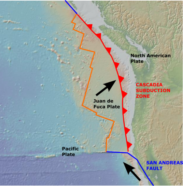
Tectonic map of the Pacific Northwest, showing the Cascadia subduction zone. Base map created using GeoMapApp.
If you don’t know much about the risk posed by Cascadia, then you are not alone; indeed, for a long time even geologists were in the dark. The story of how they slowly uncovered the danger signs is the focus of journalist Jerry Thompson’s excellent new book, Cascadia’s Fault, a creditable attempt to raise awareness beyond geoscientists and emergency planners who have, as he puts it in his introduction, been “having a devil of a time getting anyone to pay attention.”
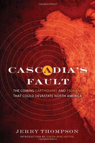
Cascadia's Fault, by Jerry Thompson
Although Cascadia is the focus of his book, Thompson’s story is actually much broader in scope. He takes us back to the early 1960s, when what are still the two largest earthquakes ever recorded shook Chile in 1960 and Alaska in 1964. Both of these events occurred on subduction zones, but back then, in a time before plate tectonics had been fully figured out, no-one knew that. Things that geologists now take for granted, such as thousand-mile long, shallow dipping thrust faults off many continental shorelines, were totally new and surprising – as were the tsunamis, capable of causing significant damage half an ocean basin away, that they generated.
Over the next decade, geologists gradually uncovered the workings of plate tectonics, and the nature of subduction zones. The deep trenches that advertised their presence could be seen all around the Pacific Rim. However, although people began to appreciate the risks these structures posed, that appreciation was not distributed equally. In Japan, Chile, and Alaska people started to worry about – and prepare for – the massive earthquakes and tsunamis that the subduction zones off their shores would one day generate. But Cascadia seemed to fly under the radar. In comparison to most of the world’s subduction zones, it seemed to be seismically quite quiet, and this led scientists to hypothesise, perhaps a little too hastily in hindsight, that Cascadia was different, and posed no real risk. Subduction had stalled, or the plates moved so easily past each other that no strain was being built up that would be released in large earthquakes.
Cascadia’s Fault tells the fascinating story of how this view was gradually overturned. It started with geodetic measurements of deformation on the coast behind the subduction zone, which suggested that the the subduction zone was, in fact, locked and accumulating strain. Then there was Brian Atwater’s discovery of drowned forests and salt marshes, lowered beneath the waterline in the subsidence that follows a large subduction zone earthquake and then engulfed by the tsunami it generated. Then, finally, a sublime bit of detective work allowed the event that killed the trees to be accurately dated. An ‘orphan tsunami’ – a large wave without any accompanying earthquake, indicating that it was generated somewhere else around the Pacific Rim – was found in Japanese records. With macabre precision, we now know that the last major rupture of the Cascadia subduction zone occurred at around 9pm on Janaury 26th, 1700 – and it was a Very Big One.
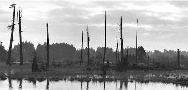
One of Cascadia's 'ghost forests', drowned following the 1700 earthquake: Source: 'The Orphan Tsunami of 1700' by Atwater et al.
Now, thanks to the work of marine scientists such as Chris Goldfinger, we know not only when the last big Cascadia earthquake happened, but also the approximate timing of the forty before that. A big earthquake can trigger submarine landslides along the whole length of the ruptured margin, and the record of those simultaneous landslides in oceanic sediment cores provides an unmatched record of Cascadia’s last 10,000 years: 41 large earthquakes, 19 of which appear to have been magnitude 9 tremors that ruptured the whole length of the margin. All of this has happened before, and all of it will happen again.
This story is excellently told, providing a good amount of detail without ever straying into jargon. It is also an excellent account of how science truly progresses. There is no one moment where the paradigm shifts, in a dramatic showdown between a young mavericks and the musty old guard: the community works on a problem together, with many scientists working on different aspects of the problem, and people gradually changing their minds as the evidence becames more convincing.
Also, despite the gravity of the threat that Cascadia poses, Thompson avoids lapsing into fearmongering. In the closing chapters, he attempts to describe how a magnitude 9+ rupture on the Cascadia subduction zone might play out for the cities, towns and residents of the Pacific Northwest – an exercise in imagination that has been made rather redundant by the real life imagery from Japan 3 months ago – but he ends with the proposition that although Cascadia’s next rupture will be a severe blow, most people can survive to rebuild – if we are adequately prepared.
After all this deserved praise it seems a little churlish to mention the only real gripe I have with this book, but you might have spotted from the picture of the cover that the foreward is written by Simon Winchester, he of the notorious (and scientifically questionable) Newsweek article. To the dismay of my now rather ground teeth, his contribution is basically that very article (literally – some sections are almost word for word) bookended with some paragraphs about Cascadia. But let’s not let a few silly pages obscure the fact that this is a truly excellent book. According to his bio, Jerry Thompson has been following the Cascadia story, on and off, for the past 25 years. It shows.
Cascadia’s Fault is published by Counterpoint Press and can be ordered online from Amazon and Barnes and Noble. Check out the book’s website for more information.
![]() When Anne first started blogging on Highly Allochthonous, I introduced her first post with the words:
When Anne first started blogging on Highly Allochthonous, I introduced her first post with the words: I was half joking, but It has been clear to me ever since that first post that Anne is a wonderful and intelligent writer, whose presence on this site has added immeasurably to its scope, relevance and credibility. I am therefore delighted to see the rest of the world properly recognising Anne’s talents: her post “Levees and the Illusion of Flood Control” has taken 2nd place in the Three Quarks Daily Science Prize, or the Strange Quark’ as it is known in those parts.




Nice plan for content warnings on Mastodon and the Fediverse. Now you need a Mastodon/Fediverse button on this blog.