
 On the 8th day of Christmas my true love sent to me: 8 streams reversing…
Wind gaps are fossil rivers: water once flowed through these valleys, but now that water has been diverted to flow elsewhere.
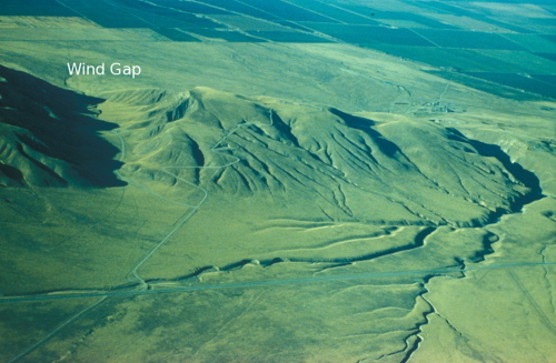
Wind Gap in Wheeler Ridge, California. Source (HT to my co-blogger Anne)
Each of the triangles on the drainage map of northern California (from a 2006 paper by Lock et al.) below marks a wind gap that occurs mid-way along a continuous north-south trending channel.
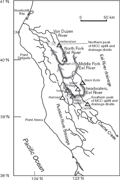
Figure 4 of Lock et al. (2006)
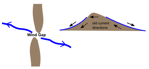
On either side of these dry sections, water in the channels to the north flow north, and water in the channels to the south flow south. But this doesn’t always seem to have been the case: the deposits left by these stream systems contain signs of their flow directions in the past, paleocurrent indicators that show that a few million years ago, water in the currently south flowing sections also flowed north, as did water in the wind gaps before they were dry. At some point, the streams south of these wind gaps have reversed themselves.
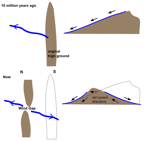
In their paper discussing the origin of these features, Lock et al. argue that their formation was the result of a relatively recent uplift event altering the drainage patterns of pre-existing streams and rivers. Initially, the high ground was in the south, and water drained northwest all the way from here into the sea. But over the last few million years, something has caused the ground in the middle of the area to rise up as the ground in the south subsided. This created a wind gap-bearing barrier to water flowing from further south, and by reversing the topographic slope in this area, forced the streams there to turn back on themselves, so that they now flowed south.
So, what caused this uplift? Northern California is actually parked right on top of a rather interesting tectonic situation: it marks the spot where the boundaries of three tectonic plates intersect with each other. To the north is a subduction boundary, where the Juan de Fuca plate is being thrust beneath the Cascades. To the south, the Pacific and North American plate are sliding past each other along the San Andreas Fault. Trending west out to sea from Cape Mendecino (CM in the northwest of the drainage map above), the Gorda and Pacific plates move past each other along a ridge transform fault (the Mendecino fracture zone). Due to the presence of this triple junction, Northern California marks the boundary between two distinctive styles of deformation on the coast of west North America: subduction thrusting to the north, and strike slip motion to the south.
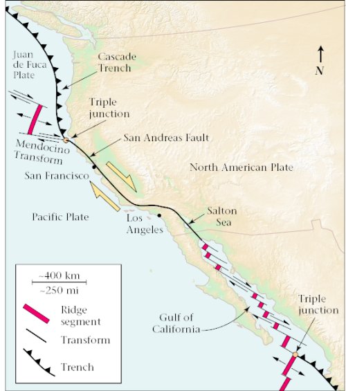
The net result of the relative motions between the North American, Pacific, and Juan de Fuca plates is that the triple junction does not stay in the same place: in the last few million years, it has gradually moved northwards along the North Californian coast, lengthening the San Andreas Fault at the expense of the Cascade Trench. This migration squashes the crust ahead of it, causing uplift, and stretches the crust behind it, causing subsidence, causing a region of transient uplift to also gradually move up through northern California, reversing streams as it goes.
By tracking the changes in drainage by mapping, correlating and dating the river deposits in northern California, you can chart the passage of the triple junction with much higher resolution than is possible with other geological indicators. And given the interests of myself and my co-blogger, a study revealing an interesting and informative link between tectonics and hydrology is sort of perfect for this blog , don’t you think? Although if the hydrology stuff makes sense, it’s really only thanks to Anne’s editorial assistance – and if it doesn’t, it’s only thanks to me.
Lock, J., Kelsey, H., Furlong, K., & Woolace, A. (2006). Late Neogene and Quaternary landscape evolution of the northern California Coast Ranges: Evidence for Mendocino triple junction tectonics Geological Society of America Bulletin, 118 (9) DOI: 10.1130/B25885.1
Comments (1)
Links (2)-
-
Pingback: The 12 geological days of Christmas: a reprise | Highly Allochthonous
Pingback: 12 Months of Highly Allochthonous | Highly Allochthonous