Flooding around the world (26 June edition)

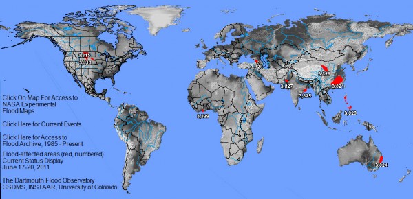
A post by Anne JeffersonSince the last edition of flooding around the world, flooding along the Mississippi River has mostly subsided, but flooding continues along the Missouri River and in China. Several new flood wetspots have also popped up, as the image below from The Flood Observatory (at the University of Colorado) depicts.

Current flooding, image from The Flood Observatory (http://floodobservatory.colorado.edu/)

Current flooding, image from The Flood Observatory (http://floodobservatory.colorado.edu/)

The big stories are flooding in China, along the Missouri River, and on the Souris River in Saskatchewan and North Dakota. The best summary I’ve seen is by Jeff Masters of Weather Underground, who gets straight to the story in his headline: “Floods overwhelm North Dakota levees; floods kill 175 in China”. The Flood Observatory also has a handy table that includes flood cause, duration, and a snippet of recent news for each of the flood events pictured on the image above.

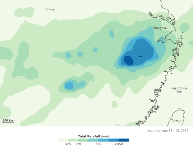
TRMM measured precipitation over China, June 13-19, 2011 (NASA image)

TRMM measured precipitation over China, June 13-19, 2011 (NASA image)

China

Flooding continues in central and southern China’s Zhejiang, Jiangsu, Anhui, Jiangxi, Hubei, Hunan and Guangdong provinces, and in parts of the northwest Gansu Province (though drought is still the more dominant threat there).

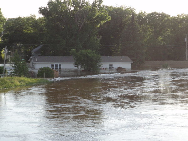
NOAA Hydrologist Steve Buan just took this photo from Broadway Bridge looking upstream in #Minot, ND  via Justin Kenney on Twitpic

NOAA Hydrologist Steve Buan took this photo on 25 June from Broadway Bridge looking upstream in Minot, ND, via Justin Kenney on Twitpic

The Souris River and Minot, North Dakota

More than 11,000 people have been evacuated and more than 4000 homes inundated in record-breaking flooding in Minot, North Dakota and surrounding communities. Levees in Minot were over-topped, even after emergency preparations by the Corps of Engineers. The river crested yesterday about 2 m above major flood stage, but will remain extremely high for a few more days.

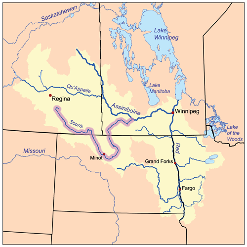
  • Where is the Souris River? It is not part of the Missouri basin. No, as the map below shows, the Souris is part of the Assiniboine River River watershed. The Red River, which flooded earlier this year also drains to the Assiniboine, but the currently flooding Souris doesn’t have the same lake bottom geologic history as the Red.
  • Map of the Souris River and related watersheds, from Wikipedia

    Map of the Souris River and related watersheds, from Wikipedia

  • Why is there flooding?The seeds of the record floods along the Souris and Missouri Rivers were sown beginning last summer, with persistent heavy rains (that lead to flooding), a wet fall, a snowy winter, and then another very wet spring.
  • What’s it like in Minot right now?The city is effectually split in half by the flooding, with 1 in 3 residents is evacuated. It is unclear whether the municipal water supply of Minot and a nearby Air Force base has been contaminated, so the city is under a boil water order. (CNN wire report, 26 June). Residents in unflooded portions of town and surrounding areas are doing what they can to shelter the evacuees and take care of the belongings they got out before the flood arrived. (AP, 26 June)
  • Are there problems anywhere else on the river?Yes, the flood has displaced hundreds in southeastern Saskatchewan, upstream of North Dakota (CBC, 20 June). Floodwaters in that area are now receding (Montreal Gazette, 25 June). Downstream of North Dakota, residents along the Souris River in Manitoba are working to build up their defenses, because the flood will be there in less than two weeks. (Toronto Sun, 25 June). This new flooding arrives on top of already a record-breaking year for floods for the province, with $1 billion in damages already and 3 million acres of farmland still soaked and unplantable (UPI, 22 June).
  • Are there any good pictures of the flooding?The Sacramento Bee had a striking collection of photos on Friday, 24 June. A lot of the news stories linked to above have photos, NASA’s Earth Observatory has an event page with four sets of images so far, and I’d be really surprised if the other big photo news blogs didn’t have a set of images at some point in the next few days.
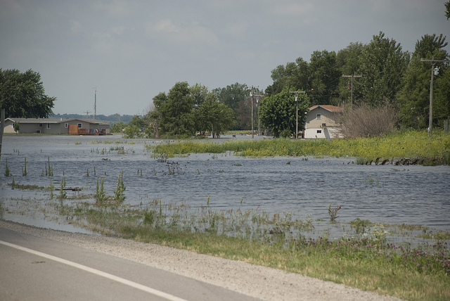
Holt County Levee District No. 10, a non-federal levee near Rulo, Neb., experienced an overtopping breach June 18, 2011, flooding U.S. Route 159 and the surrounding area. Photo by Diana Fredlund, US Army Corps of Engineers. Image from Flickr.

Flooding from the breach of a non-federal levee near Rulo, Nebraska on 19 June. The levee overtopped and breached on 18 June 2011, flooding U.S. Route 159 and the surrounding area. Photo by Diana Fredlund, US Army Corps of Engineers. Image from Flickr.

Missouri River

Record flooding continues to move downstream in the Missouri River system. Heavy snowpacks and a lot of rain in the Upper Missouri have forced unprecedented releases of water from the dams along the river in the Dakotas. Right now, the biggest flood problems seem to be in Missouri and Iowa, but high water and evacuated areas are stretched all along the river, and the flood won’t fully recede for months. The National Weather Service has a flooding information page set up, with regular updates.

  • How has the flood been affected by the dams along the Missouri River? There’s a lot of public debate over whether the Corps of Engineers management plan for the river favors upper basin states’ desires to keep their reservoirs full over the flood-control needs of downstream states. (KC Monitor, 25 June) People are asking why the Corps didn’t release more water earlier this year, in order to prevent such massive releases now. But, flood prediction models couldn’t have forecast the week after week of heavy rain that fell this spring. Still, I expect people and politicians (especially in the lower basin) to keep talking about this as long as the flood and its cleanup lasts. Here’s an editorial from the Des Moines Register (25 June) that tries to put things in perspective.
  • How are the levees? “A total of four levees in Missouri have been breached along the Missouri River, according to officials with the U.S. Army Corps of Engineers in Kansas City. The epicenter of the flooding in Missouri is located in Holt County, where two levees have been overtopped and two levees have been breached by raging water flowing down from a reservoir in South Dakota. ” (KC Monitor, 25 June) There have also been levee breaches in multiple places on the Iowa side of the river (Reuters, 25 June).
  • What about the nuclear plants? Two Nebraska nuclear plants are in the path of Missouri flood waters, but emergency levees are 0.6 m higher than the expected crest at the Fort Calhoun plant (Omaha World-Herald, 17 June) and 2 m higher than the expected crest at the Cooper station (Chicago Tribune, 25 June). [Update: 6:30 pm 26 June: While I was writing this post, news wires reported than a temporary berm around the Fort Calhoun plant breached last night. Two feet of water now surround reactor buildings, but the reactor systems were unaffected and inside water-tight buildings. (Reuters)] Charmingly, residents near the plants are unconcerned, according to the Chicago Tribune story.
  • What does the flood look like from above? NASA’s Earth Observatory has 9 satellite images of the flood, so far. There’s also a nice video taken on 9 June from a low-altitude airplane, by KETV news.

Open Thread

Please use the comment thread below to add links to updated news stories, videos, or imagery about any floods that are occurring in the next few weeks. I’ll write another flood update in mid-July. If there are particular floods you are interested in, or if you’d like me to delve more into the hydrological details, please let me know.

Categories: by Anne, geohazards, hydrology

Stuff we linked to on Twitter last week

A post by Chris RowanA post by Anne Jefferson

Earthquakes

Volcanoes

Fossils

(Paleo)climate

Water

Environmental

Planets

General Geology

Interesting Miscellaney

Categories: links

When a tree falls in a stream, there’s always something around to make use of it.

A post by Anne JeffersonResearchBlogging.org Allochthonous may have some obscure usage related to rocks, but in ecology, allochthonous material is a major concept that underpins thinking about nutrient cycling and food web dynamics. In its most general definition, allochthonous material is something imported into an ecosystem from outside of it. Usually, ecologists are thinking about organic matter and the nutrients (C, N, and P) that come with it.

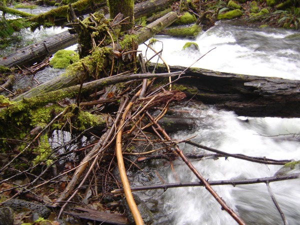
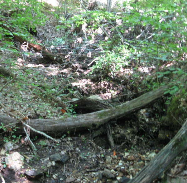
Allochthonous material in the form of coarse particulate organic matter in a mountain stream in Oregon.

Allochthonous material in the form of coarse particulate organic matter in a mountain stream in Oregon.

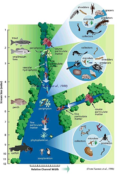
In streams, allochthonous material includes leaves that fall or are washed into the water and branches and trees that topple into the stream. These would both be called “coarse particulate organic matter” or “CPOM” in the lingo of stream ecologists. In headwater streams, especially in forested areas, there is a lot of CPOM, and the community of aquatic organisms has a high proportion of “shredders” – the critters that that feed on CPOM and break it up into tinier bits called “fine particulate organic matter” or FPOM. In turn, organisms called “collectors” make use of the FPOM by filtering it from the water or accessing it in the sediments. [Allochthonous material can also include dissolved organic matter (DOM) carried into the stream by overland or subsurface flow.]

Schematic illustration of the River Continuum Concept, as modified from Vannote et al. (1980)

Schematic illustration of the River Continuum Concept, as modified from Vannote et al. (1980)

As you move downstream from the headwaters toward medium-sized rivers, the stream channel becomes wider and allochthonous input from overhanging forest and riparian vegetation decreases in abundance and importance relative to primary production (or autochthonous organic mattter) driven by available sunlight. In other words, algae and aquatic plants become the most important food producers. Organisms called “grazers” who scrape algae from surfaces become an important component of the aquatic food web, and grazers become less abundant.

Farther downstream, the ecosystem shifts again, as there is so much FPOM moving with the water and sediment, that collecters far outnumber either shredders or grazers. There’s still allochthonous input from the banks and being carried in by tributaries, and there’s still primary production occurring in the stream, but upstream “system inefficiency” or “leakage” in the processing of nutrients and organic material lets large river aquatic communities be based on material washing in from upstream.

The adjustment of river ecosystems in a downstream fashion that I’ve described above is part of the “river continuum concept”, described by Vannote and colleagues in 1980 in the Canadian Journal of Fisheries and Aquatic Science, and it is one of the unifying principles of modern stream ecology. At its root, the river continuum concept is driven by the relative proportion of allochthonous to autochthonous organic matter inputs to the stream.

While I’m not an ecologist, I was raised by one and I work with them, so when I hear the word allochthonous, I pictures leaves and logs in streams, rather than anything to do with rocks. So, I’ll end this post with some nice pictures of allochthonous material.

An overwhelming amount of allochthonous material in a headwater stream, Gaston County, North Carolina

An overwhelming amount of allochthonous material in a headwater stream, Gaston County, North Carolina. One of my MS students showed that debris jams like this were the biggest driver of groundwater-stream interactions, variations in sediment size, and changes in water chemistry in these tiny streams.

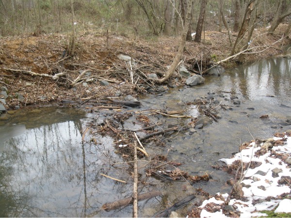
Allochthonous organic material in Clark Creek, Charlotte. High water has washed branches and leaves into the creek, where they got hung up on the riffle (or riprap).

Allochthonous organic material in Clark Creek, Charlotte. High water has washed branches and leaves into the creek, where they got hung up on the riffle (or riprap). What role do natural and artificial geomorphic structures (with their FPOM trapping abilities) play in promoting ecosystem health in urban streams? My colleagues and I are trying to find out.

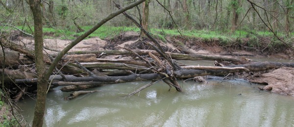
Large wood jam on Mallard Creek, near Harrisburg, NC

Large wood jam on Mallard Creek, near Harrisburg, NC. For several years, I've taken my Fluvial Processes class to this spot, in part so that they can observe the geomorphic effects of wood in streams.

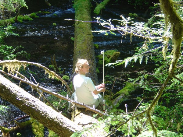
Wood in streams is utilitarian. During my PhD, I used stable large logs to cross streams and attach equipment.

I use large logs to cross streams and attach equipment. Here, in a spring-fed stream in Oregon, with extremely stable water levels and no floods, allochthonous material that falls into the stream stays where it falls and forms a substrate for a fabulous community of mosses and ferns.

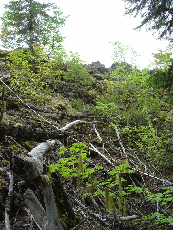
Not a stream. Allochthonous input onto the surface of a lava flow, from the edge of a forest.

Not a stream. Here we are looking at allochthonous input onto the edge of a lava flow, from the forest beyond. On this young lava flow (in the Oregon Cascades), I found substantially greater soil depth near the edge of the flow, where organic acids from decaying allochthonous organic matter had probably sped up the weathering process, as well as contributing directly to the soil. In my PhD dissertation, one subsection had "allochthonous inputs" for a title.

Vannote, R., Minshall, G., Cummins, K., Sedell, J., & Cushing, C. (1980). The River Continuum Concept Canadian Journal of Fisheries and Aquatic Sciences, 37 (1), 130-137 DOI: 10.1139/f80-017

Categories: by Anne, environment, hydrology, photos

The far-travelled ground

A post by Chris RowanBe honest: when Evelyn asked the geoblogosphere, ‘what’s your favourite geology word?’, you all knew which word I was going to pick, didn’t you? Allochthonous. Allochthonous, the word that no-one can spell. Allochthonous, the word no-one can pronounce, it seems, given that I am asked how you do whenever I meet a reader of this blog. I personally think it trips off the tongue quite nicely. It is also a word with heft: it sounds like it means something, something important, interesting, monumental. And it does.

‘Allochthonous’ is derived from two greek words:

  • αλλος or allos, meaning other, or different;
  • κθονος or kthonos, meaning earth.

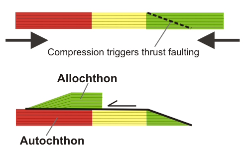
So, literally, allochthonous means ‘different earth’; or ‘stuff that’s not from around these parts…’ In tectonics, it is generally used to describe a sequence that has been moved a long distance from its original location by faulting (most usually, thrust faulting). For example, a sequence of sediments which were originally deposited in the deep sea, and have then been thrust over shallow marine or continental deposits of a similar age.

The formation of an allochthonous sequence by motion along a large thrust fault. The 'autochon' is the stuff that stays put, relatively. Colour coding represents continental (red) shallow marine (yellow) and deep marine (green) rocks.

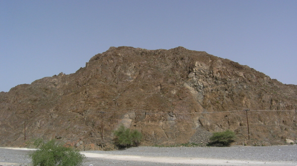
Ophiolites would be another good example: the ocean crust itself thrust up from the depths onto the shore.

Part of the lower crustal sequence, Oman ophiolite. Photo taken by C. Rowan, 2010

In a wonderfully evocative turn of phrase, John Challinor’s Dictionary of Geology describes an allochthon as ‘the far-travelled ground’, and I think this gets to the heart of why I’ve always loved the word: it embodies the central idea of plate tectonics, the notion that the earth is continuously being reshaped and transformed by the large-scale movement of bits of crust across the Earth’s surface. Allochthonous thrust sheet, or nappes? You’re in a continental collision zone, where the opposite shores of a once large ocean – and bits of the ocean itself – are all mashed up against each other. Allochthonous terranes? Basically a larger scale version of the same thing, with island arcs and microcontinents once spread across half the planet getting welded together above a subduction zone. Allochthonous conjures up all of the things that I find most fascinating about geology. Plus, it has lots of syllables, something I also have an unhealthy fascination with…

As it turns out, the word allochthonous does also pop up in other branches of earth science, most particularly within the watery realms of my co-blogger. There, it is used to describe material, particularly organic matter such as leaves, which fall or get washed into a stream or lake from the surrounding land (Anne has now provided a more detailed explanation). I don’t think Anne thinks it’s quite as cool a word as I do, but it’s nice that the name of our blog does have a meaning in both of our areas of research.

Categories: basics, geology, hydrology, tectonics

Seismo-volcanism in Eritrea

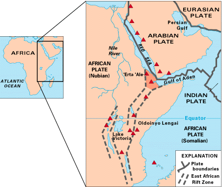
A post by Chris RowanThe Great Rift Valley marks where East Africa is slowly attempting to break away from the rest of the African continent, at a rate of less than a centimetre a year. At the north-eastern end of the rift, where it links to the oceanic spreading centres in the Red Sea and the Gulf of Aden, it has come very close to succeeding, producing the Afar triangle. Low, hot and arid, and home to numerous volcanoes and ultra-saline lakes, it’s the closest thing we have to an onland oceanic spreading centre – a structure that is normally found beneath 4 kilometres of water.

The Afar triangle is located at the junction between the East African continental rift, the Red Sea and Gulf of Aden oceanic rifts. Source: USGS

At the beginning of last week, Nabro, a volcano that has not been previously active in historical times, began to erupt, with ash clouds and a new lava flow spotted in satellite imagery. The Volcanism Blog and Eruptions are doing their usual excellent job of covering the eruption, but this event was also accompanied by some interesting seismic activity, which I thought was worth looking at in a bit more detail.

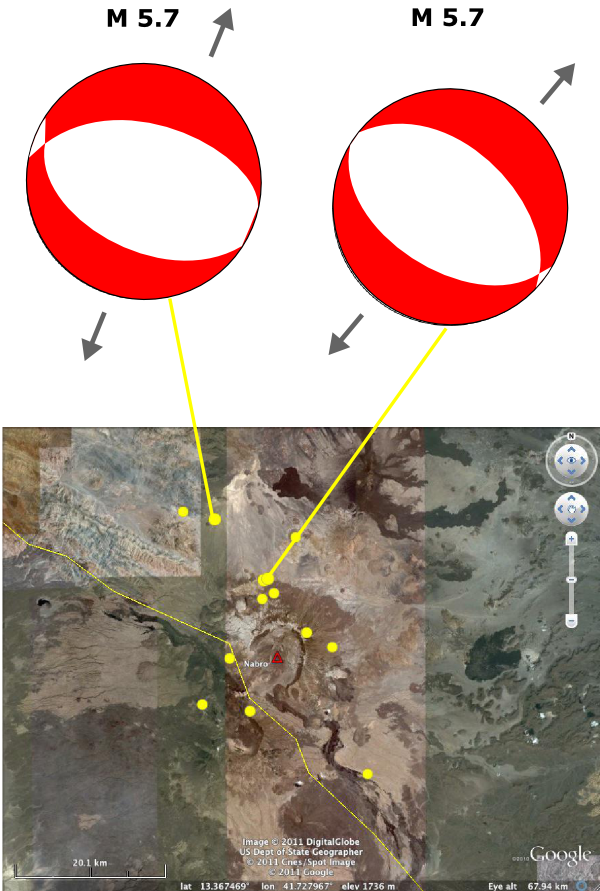
The global seismometer network detected 13 magnitude 4 or greater earthquakes near the border between Ethiopia and Eritrea on Sunday 12th June, all within a 20 km radius of the main caldera. The two largest quakes in this sequence had a magnitude of 5.7, occurred within 30 minutes of each other, and both had extensional focal mechanisms that indicated that the crust was being stretched – or pushed apart – in a northeast-southwest direction (the USGS information pages for these earthquakes are here and here).

Earthquakes around Nabro on the 12th June, showing the extensional focal mechanisms for the two largest events in the sequence.

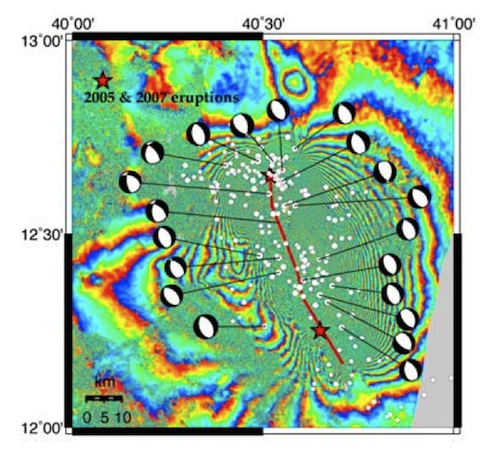
The reason I found this interesting was that it reminded me of a paper published a couple of years ago describing a massive dike injection event in the Afar triangle in 2005. Magma rising through the crust opened a 60 kilometre long, linear fracture beneath the surface and forced itself in, pushing the crust apart by up to eight metres; a process very reminiscent of what goes on at true oceanic spreading centres. One notable feature of the accompanying seismic activity was that most of the larger earthquakes had focal mechanisms showing northeast-southwest extension. There was also an associated volcanic eruption: at Da’Ure, a fissure vent of Dabbahu.

Focal mechanisms for the major earthquakes in the 2005 Dyke injection sequence. From Ayele et al., 2009 (see text for link).

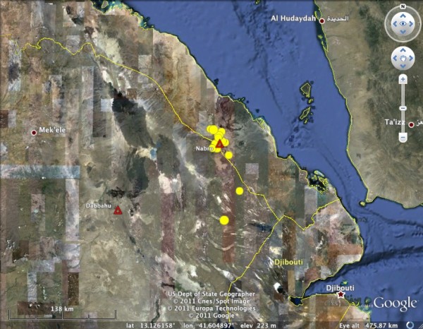
Location of the recent activity compared to the 2005 diking event centred on Dabbahu.

The 2005 diking event occured about 150 kilometres to the southwest of the current activity. Both are obviously linked to the regional extension associated with rifting. What is less clear is if the recent seisimicity – and the eruption of Nabro – can also be linked to dike injection at depth. In 2005, the seismic activity went on for a couple of weeks, and the migration of earthquake locations from northwest to southeast over time clearly showed the movement of injected magma along the dike away from the initial injection point. In contrast, the recent bout of seismic activity appears to have been much more short-lived, and although the earthquakes are (very roughly) distributed along a northwest-southeast trending line, there is no obvious migration of the epicentres over the course of the sequence. This may just be an issue of scale: last week may have seen a much smaller-scale injection of magma than in 2005, but in both cases the earthquake focal mechanisms were controlled by the regional extension, which will produce many more such events as Afar continues its slow transformation into a small ocean basin

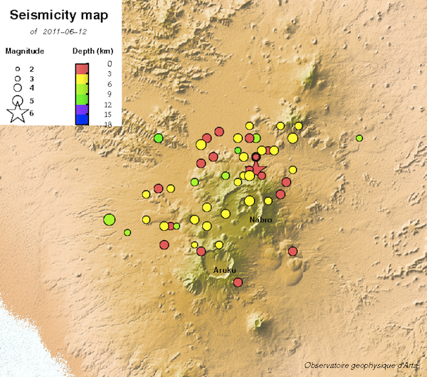
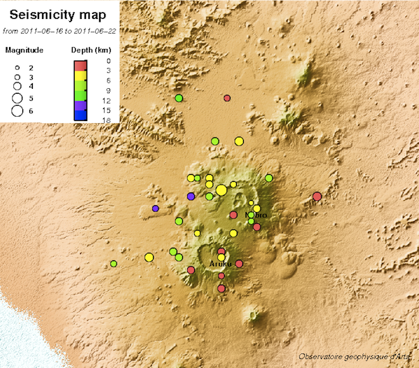
Update: via the Earthquake Report, I’ve found a local seismometer network in Djibouti, the country south of Eritrea, which has the ability to pick up smaller earthquakes associated with the Nabro eruption. According to their page commenting on the eruption, although activity really kicked off on the 12th June, there was some seismic activity in the area in May – around half a dozen approximately magnitude 2.5 earthquakes, mainly to the northwest of the Nabro caldera. They also have a more detailed map of the seismicity for the 12th June (with almost 50 events) and also a map of the last 7 days of activity. Despite the addition of many more lower magnitude earthquakes to this sequence, there doesn’t seem to be any particular trend in the location of the seismic activity.

Magnitude 2+ Earthquakes around Nabro on the 12 June. Source: Observatoire Geophysique Arta

Magnitude 2+ earthquakes around Nabro, 16-22 June. Source: Observatoire Geophysique Arta

Also, if you’re interested in the tectonic forces driving the earthquakes and volcanism in the Afar triangle, and want to learn about the latest (pre Nabro) research on the activity in this area, check out this superb article by Alex Witze.

Categories: earthquakes, focal mechanisms, tectonics