Writing Challenge, Week 2: Define progress.

A post by Anne JeffersonSciwrite by Chris RowanIt’s been two weeks since I issued the initial challenge to join me in a month-ish of intense writing activity. Last week, I told you what I was doing and how it was going, and 13 brave commenters shared (and even graded) their own early progress. There’s also been sporadic use of the #sciwrite hashtag on Twitter, though I’ve noticed that there seems to be some association with declarations of suboptimal progress on writing committments.

I’ve been making some of those declarations myself. I proclaimed that I’d have one part of the results section done last Monday, complete methods and results by Friday, and introduction, discussion, and figures in progress too. Well, uh, … my week of writing didn’t quite go according to plan. Instead, I spent Monday’s writing time puzzling over that same results section. I just couldn’t wrap my head around the data for one of the field sites. Nothing I read helped me explain it. I finally decided I needed to dive back into the GIS data for the site, and on Thursday I found my smoking gun. A minor georeferencing problem essentially caused a portion of my dataset to be gibberish. ARGH!!! Friday, I redid the GIS work and began the process of rewriting the section. I had 600 words in that section this time last week. Now I’m up to 772, but every single one of those words has been changed multiple times in the past seven days. They are hard fought words and simple counting does not provide an adequate measure of progress. Instead, I’m viewing it as having done my due diligence on the dataset and saved myself from going way out on a limb to try to explain something that wasn’t actually there. So much better to have discovered this now than during peer review.

Thus, tonight’s subheading is “Define progress.” By any numeric metric, my week has mostly been a wash, but in terms of the quality of my science, it’s been a big gain. Not only because the data are now right, but also because all the reading, thinking, and head-scratching that I did in trying to figure this out has advanced my thinking not only about the paper, but about the way landscapes behave. Maybe this was just the “boink” I needed.

How about you? Did your week go smoothly and according to plan? Or do you need to define progress in a new way?

Categories: academic life, by Anne

Stuff we linked to on Twitter last week

A post by Chris RowanA post by Anne Jefferson

Other posts on All-geo

Blogs in motion

Volcanoes

Earthquakes

Fossils

(Paleo)climate

Water

Environmental

Planets

General Geology

Interesting Miscellaney

Categories: links

Scenic Saturday: Wood in Streams

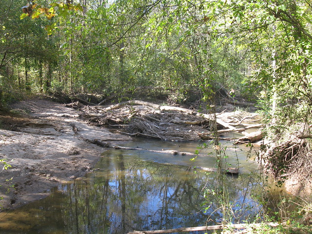
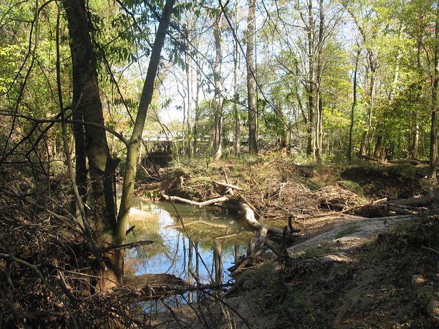
A post by Anne JeffersonOne of our field trips in my Fluvial Processes class takes the students to the lower reaches of Mallard Creek, the urban stream that drains the northern portion of Charlotte, including our campus. For most of its length, Mallard Creek is highly incised, so it’s quite a surprise to see the stream near its mouth, where it is more free to meander through a floodplain forest. For their field exercise, the students measure meander geometry and plot it against the classic Leopold, Wolman and Miller relationships, they attempt to identify bankfull channel geometry, and they contemplate the effects of wood on channel morphology.

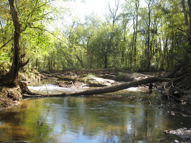
Looking upstream at the big wood jam (photo by A. Jefferson, 2011)

Looking upstream at one of the big wood jams in Mallard Creek, near Harrisburg, North Carolina

Looking downstream at the same wood jam (Photo by A. Jefferson, 2011)

Looking downstream at the same wood jam as above. Notice how much smaller wood (and trash) has piled up against the big keystone logs.

Wood is perhaps the most striking feature of this reach of Mallard Creek, because it is everywhere, and because it is profoundly shaping the channel geometry and meandering behavior. So it is appropriate that Mallard Creek had an important role in the scientific recognition of the importance of wood in shaping fluvial systems. A 1979 article by Ed Keller and Fred Swanson, “Effects of large organic material on channel form and fluvial processes“, is the fifth most cited paper in geomorphology, according to an analysis done by Martin Doyle and Jason Julian in 2005. As part of their analysis, they asked the authors of the highly cited papers to speak to what inspired the work. Here’s what Keller said:

I first recognized the importance of large woody
debris while doing PhD work on pools and riffles in
Wildcat Creek near Lafayette, Indiana in 1971. I observed
that the debris formed a jam that backed up
water at high flow. The backwater caused a chute to
form across a bend, facilitating a meander cutoff. I
nearly forgot this until starting as a new Assistant
Professor at the University of North Carolina at Charlotte.
I was looking at Mallard Creek near the university
for a site to study pools and riffles. The floodplain
was forested, and I was complaining to myself that I
couldn’t find a “natural” site without large woody
debris interfering with the morphology I was looking
for. Then it happened—I heard a large groan followed
by a loud cracking. I walked around a bend just in time
to see a large tree fall into the stream with a great
splash! I suddenly had the a-ha–this is “natural”–these
streams with forested floodplains and lots of trees on
the banks are greatly modified by large woody debris
that enters the active channel! Then in 1973, I moved
to the University of California, Santa Barbara, and
started work in the redwood forest of northwestern
California where the woody debris that ends up in
streams is truly gigantic. I contacted Fred Swanson,
who was working for a US Forest Service Research
Laboratory at Oregon State University, and suggested
we write a paper on the role of large woody debris on
stream channel form and process. Fred had been working
for several years on large woody debris in streams
of the Oregon Coast Ranges. We had a great collaboration
at just the right time for the emerging field of
forest geomorphology.

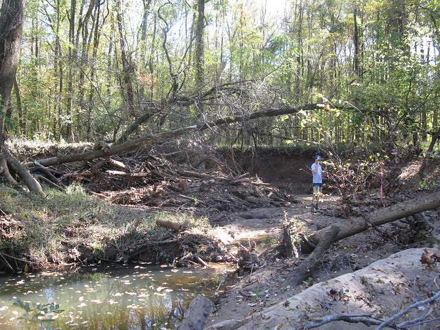
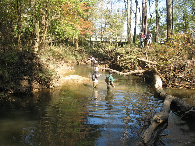
I haven’t seen a tree fall into Mallard Creek, but in the five years I’ve been bringing my class to this site, I’ve seen some pretty remarkable changes. The photos below show a meander that cut off sometime between May 2010 and October 2011. In May 2010, the “new” channel (on the left) existed but was very narrow and didn’t carry water at low flow. Now, the “old” channel (on the right) is largely sedimented (and wood-jammed) in and carries only a trickle of water at low flow. While the meander would likely have cut off at some point in the future, my interpretation is that a series of large wood jams in the old channel backed up water during high flows, increasing overbank flooding, and greatly accelerating the cut off process.

Old channel on the right, new channel on the left (photo by A. Jefferson, 2011)

A recently cutoff meander in Mallard Creek. The new channel is to the left, the old channel (active in May 2010) flowed to the right.

Looking down the old channel (photo by A. Jefferson)

Looking down the old channel, from atop the large wood at the cutoff point.

Looking down the new channel (photo by A. Jefferson, 2011)

Looking down the new channel, with students for scale. The students on land are on an island between the old and new channels.

Categories: by Anne, environment, geomorphology, photos, publication, science education

Friday focal mechanisms: aftershocks in eastern Turkey

A post by Chris RowanAlmost a fortnight after a magnitude 7.1 earthquake shook Eastern Turkey, the region continues to suffer from aftershocks, and there were two pretty big ones earlier this week: a magnitude 5.2 on Tuesday, and then a magnitude 5.6 on Wednesday. As this rather harrowing CCTV footage shows, the shaking from the latter quake was powerful enough to push more buildings past the point of collapse, killing at least 13 people.

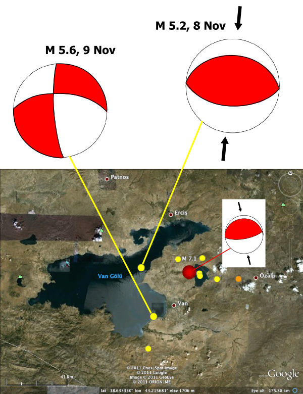
Like the original shock, the focal mechanism for the smaller M 5.2 tremor on Tuesday indicates north-south compression on an east-west oriented thrust fault (a primer on interpreting focal mechanisms). It is 20-30 km directly west of the main shock, so potentially occurred on the same fault that originally ruptured a couple of weeks ago. In contrast, the more damaging M 5.6 quake was 30-40 km to the southwest, and has a strike-slip focal mechanism.

Focal mechanisms for the two M 5+ aftershocks of the Van earthquake in Eastern Turkey this week. Red circle and inset focal mechanism are for the M7.1 main shock.

As I discussed in my original post, and talked about in a bit more detail on the Scientific American guest blog, tectonics in this region are complicated, due to the transition between continental collision further east in Iran, and the strike-slip ‘escape’ tectonics that drive activity on the Anatolian Faults further to the west in Turkey. So we might expect to be seeing thrust and strike-slip earthquakes mixed up with each other. However,the precise type of deformation that the focal mechanism represents is a little unclear in this instance. Every focal mechanism has two ‘focal planes’, which represent the two possible ways the ground could have moved in the initial rupture to produce the first-motion patterns seen on the global seismograph network. Without additional information, such as a surface rupture or knowledge of regional structure, it is sometimes difficult to know which of the focal planes actually corresponds to the fault.

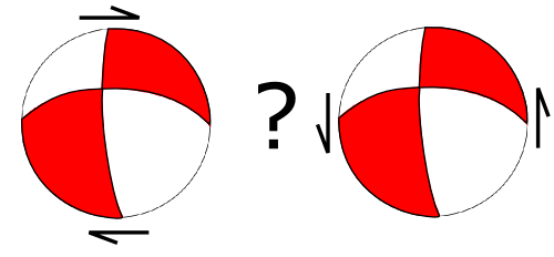
In the case of Wednesdays earthquake, the focal mechanism tells us that it was due to right lateral strike-slip on a fault that runs from east to west, or left-lateral strike-slip on a fault that runs from north to south.

Two possible interpretations of the M 5.6 aftershock on Wednesday, depending on which of the focal planes is the fault plane.

The first option, an east-west running strike-slip fault, is more consistent with the overall regional deformation (Turkey moving west). But the main shock last month tells us that this particular area is also experiencing north-south compression, which could be accommodated by strike-slip on a north-south oriented fault just as easily as thrusting on an east-west trending fault. This ambiguity is a useful reminder of the limits of studying tectonics from a distance: you can usually see the big picture, but without knowledge of local geology and structure you can’t always unravel the detail.

Categories: earthquakes, focal mechanisms, geohazards

A short FAQ on earthquakes and fracking

A post by Chris Rowan

So, I’ve been hearing that hydro-fracking to extract shale gas can cause earthquakes. Is that true?

Yes. A report released just last week concluded that some moderate earthquakes off the northwest coast of England in 2010 were caused by fracking, finding a strong correlation between seismic activity and injection of fluid down a nearby gas well (see this excellent write up by Eric at the Dynamic Earth). Another recent report cautiously suggested a similar association between hydrofracking and an increase in seismic activity in southern Oklahoma.

Oklahoma, you say? Where there were those big earthquakes last weekend?

There were indeed a couple of fairly big earthquakes in central Oklahoma last weekend. However, whilst earthquakes of this size are relatively uncommon in the interior of the US compared to, say, California, they are not unusual from a geological perspective. There is nothing to suggest a link to any shale gas drilling.

They’re certainly a lot bigger…

Yes, the earthquakes associated with fracking in the studies mentioned above were mostly magnitude 1.5-2.5, and all were less than magnitude 3. They therefore released many thousands of times less energy than the magnitude 4.6-5.6 earthquakes that made up the main shocks in Oklahoma. Basically, if we had the ability to pump that much energy into the ground, we’d probably be beyond the need to drill for shale gas in the first place.

The other argument that I’ve heard against these earthquakes being caused by fracking is that they’re also deeper.

This is potentially a little misleading. The earthquakes had a depth of around 5-7 km, which is not ‘too deep’ in the sense that we can’t drill wells that deep; we certainly could if we needed to. The key point is that the horizon being targeted by the gas drilling in Oklahoma is apparently mainly found at 1-3 km depth (see p49 of this pdf). Perhaps even more importantly, the majority of the drilling is in counties to the southeast. It is geography rather than any inherent properties of the earthquakes themselves that definitively rules out drilling as a suspect: it appears there is no gas drilling going on near the Wilzetta Fault, and the seismic activity that fracking can trigger seems limited to within a few kilometres of a well.

So fracking only causes small, localised earthquakes around the wells?

Directly, yes. There is, however, potentially a way that fracking could indirectly trigger a larger earthquake; if the drilling was close to an active, loaded fault that was close to rupturing, pumping fluids at high pressure into the subsurface could weaken the fault enough to enable it to rupture.

As I just said, that is clearly not a possibility here. And as far as I am aware there are no recorded instances of a significant (i.e., damaging) earthquake being directly linked to fracking, or even a large earthquake where a link has even been proposed. Given how many hundreds – thousands – of shale gas wells have been drilled in the US alone in the past few years, it seems clear that there is very little real-world risk in most cases. Or alternatively, the maximum size of earthquake that can be triggered is limited due to the small areas affected by fluid injection, and the kind of event listed in the studies I mentioned earlier – magnitude 2-3 or less – is the most we need to worry about except in very specific cases.

So I can stop worrying about fracking then?

If all you’re worried about is earthquakes, yes. However, there are still valid concerns over contamination of groundwater with fluids of unknown composition (although this seems to be more of an issue with poor well sealing and storage after use than the fracking process itself). Not to mention the fact that shale gas, sold as the answer to all our energy problems (even if not a particularly carbon neutral one), may have been a little oversold, and turn out to be a temporary stopgap at best.

So, to sum up: while there are plenty of important reasons to scrutinise this fracking business, the risk of triggering earthquakes is not one of them?

So say we all.

Categories: earthquakes, geohazards, public science