Our Highly Allochthonous travels in 2011

A post by Chris RowanA post by Anne Jefferson As 2011 draws to a close, ’tis the season for retrospectives, and we’re surprised that no-one this year seems to have started up the travel meme that has been so popular in the geoblogosphere in the past. After all, it gives us all the chance to (a) boast about all the cool places we’ve been in the past 12 months, and (b) show everyone pretty pictures – what’s not to like? Perhaps it just needs someone (i.e. us) to get things moving with a month-by-month summary of our travels in 2011.

In January we were both at ScienceOnline in North Carolina, the annual chance to meet in real life all of our online friends. As usual, many interesting conversations ensued.

In February we didn’t travel anywhere, but the 20-odd inches of snow deposited by the Groundhog Day snowstorm made Chicago an entirely different place.

Animation of snowfall accumulating during the Groundhog Day blizzard.

Snow accumulation over 12 hours during the Groundhog Day blizzard 2011. Photos: Chris Rowan, 2011

In March, we explored Mammoth Cave in Kentucky, where you can see groundwater in action and where Anne’s daughter appreciated being the only person on the tour who didn’t have to duck in the low passageways between the giant main chambers. Plus, speleothems!

Frozen Niagara dripstone, Mammoth Cave, Kentucky (photo by A. Jefferson, March 2011)

Frozen Niagara dripstone, Mammoth Cave, Kentucky (photo by A. Jefferson, March 2011)

An April hike in the Smoky Mountains had Chris appreciating not just a pretty waterfall, but the long geological history that contributed to it being there.

Grotto Falls, Great Smoky Mountains National Park. Photo: Chris Rowan, 2011 (click to enlarge).

On a trip to Southern Illinois in May, Anne got to play with stream tables and see the aftermath of the Mississippi flooding that she wrote an award-winning blog post about.

Em4 model at work.

Em4 stream table model at work being played with.

Levee repair along the Big Muddy

Temporary levee repair along the Big Muddy River in southern Illinois, near the Mississippi River.

In June, we took advantage of the summer weather to take a boat trip along the shores of Lake Michigan and the Chicago River. It should come as no surprise than Anne was quite interested in the locks that ensure that the flow of the Chicago river is reversed, with water running out of Lake Michigan rather than into it as it originally did.

The locks between the Chicago River and Lake Michigan. Photo: Anne Jefferson, 2011.

There was also a brief trip to Wisconsin Dells, including an early morning hike at Rocky Arbor State Park.

Rocky Arbor State Park. Photo: Anne Jefferson, 2011.

In July, Anne won the ‘make Chris insanely jealous’ prize by getting to visit the Galapagos Islands for a Chapman conference. It was, of course, complete happenstance that the best lavas to look at were on the beach.

Anne on a ropy pahoehoe flow on the beach

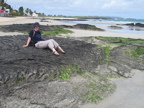
Anne enjoying the scenery on Isabella Island, Galapagos, July 2011

August‘s visit to the UK included ammonite hunting on the Jurassic coast, and a visit to some Wollemi pines that have made their home in Essex, of all places.

Cliffs west of Lyme Regis where Mary Anning collected her fossils

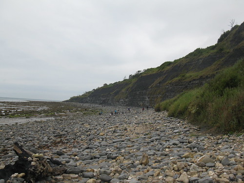
Cliffs west of Lyme Regis, Dorset. August 2011.

Wollemi pines at Mark's Hall, near Colchester, Essex. Photo: Chris Rowan, 2011

In September Chris spent a few days in Montreal for a conference, which has at least one item of geological interest in the form of Mont Royal, an eroded volcanic complex. Chris, starved of topography from all those months in flat, flat Chicago, couldn’t resist climbing to the top of it, but sadly didn’t have time for any real geologising.

In October Anne travelled to Minnesota for the GSA conference, and took the time to take a walk around one of the lakes the state is famous for – one familiar to her from her days as a Masters’ student at the University of Minnesota.

Staring Lake, October 2011

Staring Lake, October 2011, photo by A. Jefferson

November saw very little travel, because we were both busy preparing for the annual December pilgrimage to the AGU conference in San Francisco. Despite spending most of the time in entirely different sessions, hearing about totally unrelated (yet equally cool) new science, we did take the time to nip over the hill to Fisherman’s Wharf, and were treated to a lovely sunset over the Bay.

Sunset from Fisherman's Wharf, San Francisco. Photo: Chris Rowan 2011.

You are challenged to join us in summarising your travels. Go on, make us jealous!

Categories: by Anne, fieldwork, photos

Two more earthquakes shake Christchurch

A post by Chris RowanJust as it seemed that seismic activity was finally dying down in Christchurch, the city has been shaken by two more earthquakes. The USGS currently has the first shock pegged as a magnitude 5.8, and the second as a magnitude 5.9; the NZ Herald reports that the effects in Christchurch itself include loss of power, liquefaction and flooding, and rockfalls, but only minor injuries so far.

The first shock occurred about 2pm local time. The rupture was shallow (about 5 km deep) and located offshore, about 25 km miles east of Christchurch. The focal mechanism suggests westward thrusting on a north-south oriented fault. This earthquake was quickly followed by a magnitude 5.3 event. The second M 5.9 hit just under two-and-a-half hours later, 5 miles closer to the shore. It was also a relatively shallow rupture, and the focal mechanism also indicates thrusting, this time in a more northwest direction, mixed in with a bit of dextral strike-slip.

USGS focal mechanisms for the December 23rd M 5.8 earthquakes near Christchurch, with the focal mechanisms for the September 2010 Darfield and February 2011 Port Hills earthquakes, and their approximate ruptures, plotted for comparison.

(a primer on interpreting focal mechanisms)

It’s quite early, and the focal mechanism on the first shock in particular is a little poorly constrained by the look of things, but a few things stand out.

  • The area that these earthquakes occurred in is along the trend of the fault – the Port Hills Fault, that ruptured in Feburary’s magnitude 6.3 earthquake. It’s likely that the Port Hills earthquake would have caused the stress in the crust in this region offshore to have increased slightly.
  • Looking at the focal mechanism for February’s quake, it also indicates north-west directed thrusting with some dextral strike-slip.
  • So whilst based on the first, less well-constrained, focal mechanism, I thought that this new sequence was due to motion on an entirely new fault, it is possible this is just stress being released on an eastward extension of the Port Hills fault that ruptured in February, or possibly a parallel strand of the same fault system.

It will probably become clearer as more data is collected and analysed in the next few hours and days. In the meantime, the NZ Herald has a rolling updates page on the situation in Christchurch. My guess would be that the smaller size of these earthquakes compared to the Darfield and Port Hills events, and the fact that they were further away than February’s shock, meant that the shaking from these earthquakes was much less likely to cause catastrophic damage on its own. However, the cumulative effect on already damaged buildings may be an issue, and liquefaction, and the flooding and subsidence that are associated with it, could greatly increase the long-term impact.

Categories: earthquakes, focal mechanisms, geohazards

Stuff we linked to on Twitter last week

A post by Chris RowanA post by Anne Jefferson A good crop of links for your Sunday reading pleasure this week – and some new geoblogs to check out, too.

Other posts on All-geo

Newly discovered blogs

Volcanoes

Earthquakes

Floods

Fossils

(Paleo)climate

Environmental

Planets

General Geology

Interesting Miscellaney

Categories: links

Scenic Saturday: Mammoth Cave, where surface water and groundwater meet

A post by Anne Jefferson It’s that wonderful time of year, as one semester finally gives up the fight and a new one waits in the shadows, pouncing on unsuspecting students and faculty just as they breathe a sigh of that they’ve won the first battle. This past semester I taught a class on river geomorphology, but in January, my teaching takes a subterranean turn as I lead about 18 students through a semester of hydrogeology. At many research universities, surface water and subsurface water are distinct specialties and courses are taught by different faculty, so I appreciate the chance to get to indulge both of my passions. Besides which, it is really impossible to separate surface and subsurface water, as is aptly illustrated by this week’s Scenic Saturday photos.

Stage gage in River Hall, Mammoth Cave, Kentucky (photo by A. Jefferson, March 2011)

Stage gage in River Hall, Mammoth Cave, Kentucky (photo by A. Jefferson, March 2011)

This is a stage gage, which is used to visually measure water height, usually in a lake or river. Here though it’s in River Hall, 250 feet below ground in Mammoth Cave, Kentucky. Normally this area is about 45 feet above the water table, and there are benches here for tourists to rest on. But when it rains hard and the Green River floods above ground, it also backs up into the cave, with the water table rising up into River Hall. The last time it flooded into River Hall was in spring 2010, and you can read more about it from karst hydrologists here.

Digging into the origins of the cave, it’s not surprising that cave water and river water should be so well connected, because their geologic history is intricately tied. As the Green River cut downward over the last four million years, it took the regional water down with it. The multiple levels of dry trunk passages in Mammoth Cave correspond with elevations where the Green River paused in its downwards erosion and groundwater had significant time to dissolve the limestone at that elevation. You can read more about the formation of Mammoth Cave and other similar caves on the Cumberland Plateau in this paper by Anthony and Granger from 2004.

(Adapted rom Arthur N. Palmer, A Geological Guide to Mammoth Cave National Park, 1981)

Cross-section of Mammoth Cave, adapted from Palmer, 1981 and obtained from http://www.nps.gov (click image to link to source)

Most of Mammoth Cave is surprisingly dry, as far as caves go, and some would even call it a “fossil cave.” This is because of the lowering of the regional groundwater, but also because a sandstone cap above the cave-forming limestone limits the infiltration of local rainfall into the cave. Where the capstone is missing, some of the more typical cave dripstone formations are seen.

Frozen Niagara dripstone, Mammoth Cave, Kentucky (photo by A. Jefferson, March 2011)

Frozen Niagara dripstone, Mammoth Cave, Kentucky (photo by A. Jefferson, March 2011)

Categories: by Anne, geomorphology, hydrology

Friday(ish) Focal Mechanism: a kinky slab beneath Mexico

A quick look this week at the magnitude 6.5 earthquake that shook southern Mexico last Sunday. It caused a fair amount of shaking in Mexico City, and a few deaths, but apparently no major structural damage. The depth of the rupture – around 65 kilometres (40 miles) – means that the seismic energy released had spread out over a wider area by the time it reached the surface, reducing the maximum shaking close to the epicentre.

A tectonic map of the region shows that there is a subduction zone running along the southwest coast of Mexico, where the oceanic Cocos plate is being subducted eastward beneath the North American plate. The rupture depth of 65 km puts it below the crust of the overriding plate, so it must be associated with the subducting slab. The focal mechanism indicates that the earthquake was due to northeast-southwest extension (see my primer on interpreting focal mechanisms).

Map showing location of the M 6.5 earthquake that struck south of Mexico City on 11 December, its extensional focal mechanism and proximity to the subduction zone off the southwest Mexican coast.

This might seem a bit odd at first glance: subduction zones are all about accommodating plate convergence, so a compressional, thrust focal mechanism would seem more likely. However, while that would certainly be the case for an earthquake that occurred on the subduction megathrust itself, this is not the only place in a relatively cold, subducting plate where earthquakes can occur if stress is being applied to the interior somehow. One mechanism that causes extensional earthquakes within the downgoing slab is if it is being bent; for example, you often see earthquakes with normal focal mechanisms on the outer rise of a subducting plate, where the plate is just starting to bend as it is pushed beneath the overriding plate into the mantle. This earthquake was 180 kilometres behind the trench, so was obviously not associated with this initial bending. However, gravity, GPS and seismic studies of this subduction zone have found that there is probably further bending of the slab beneath Mexico. The width of the locked zone associated with the subduction thrust, where elastic strain is being built up that will mostly be released in future megaquakes, is about twice as wide (200 km or so) as it usually is, suggesting that the Cocos plate is being subducted at a very shallow angle beneath southwest Mexico, before it eventually steepens again about 275 km away from the trench. As the image below, taken from Manea et al. (2004) shows, an earlier kink, where there is a temporary steepening of the slab before it flattens out again, has also been postulated, mainly in order to explain the positions of all of the earthquakes that trace out the position of the main thrust.

Cross section showing the inferred geometry of the subducted Cocos plate beneath southern Mexico, showing mostly shallow subduction with a steeper kink about 100 km behind the subduction zone, and slab steep deepening after 250-300 km. Red and yellow circle shows the approximate location of Sunday's earthquake. Grey arrows show inferred bending of the slab. Source: Manea et al., 2004.

Where does last Sunday’s earthquake fit into this geometry? It is located on the second shallowly dipping section of the subducted Cocos plate, about half way between the first steep section and the end of shallow subduction. This is a plausible location for an extensional earthquake; the slab will be starting to get stretched as the plate ahead of it is pulled down more steeply into the mantle. As the figure above shows, there were four other large earthquakes associated with the second bend in the plate; after a very brief search, I found the record of the 1999 6.9, which also has an extensional focal mechanism. So it seems reasonable to interpret last Sundays earthquake as a plate bending event, found where the Cocos plate is starting to transition from shallow to steeper subduction.

Of course, that still leaves us with a mystery: why is the dip of the subducting slab initially so shallow? If you look back to the map in the first figure, you’ll notice that whilst the crust being subducted beneath the west coast of Mexico belongs to the Cocos plate, you don’t have to travel much farther offshore before you cross another plate boundary – this time, a mid-ocean ridge – and find yourself on the Pacific plate. Although the ridge is still active and producing new crust, it is doing so at a slower pace than the Cocos plate is being subducted beneath Mexico. So over time, the ridge is getting closer and closer to the trench, and closer and closer to being subducted itself; a little further to the north the ridge and trench have already collided with each other.

One consequence of this is that the crust being subducted beneath Mexico is not very old; after cooling and solidifying from hot, molten magma at the ridge, it lingers on the surface for just a few million years after being created before it gets pushed back down into the mantle again. And if you’re subducting unsually young crust, that means you’re also subducting unusually warm crust: the way that oceanic crust is created means that it starts hot and gradually cools over tens of millions of years. Because hot, young crust is more buoyant – and therefore harder to subduct – than old, cold, dense crust, this might explain the shallow dip. The additional buoyancy of young Cocos crust makes it want to stay near the surface for a little bit longer, leading to shallow subduction. But eventually the slab is called back to a more proper angle for its return back to where it came from, even if it registers a seismic protest as it does so.

Categories: earthquakes, focal mechanisms, tectonics