Creation geologists: going forward to the past

This NY Times account of the “First Conference in Creation Geology” should ring a few bells, because I blogged about it way back at the beginning of September. Take that, mainstream media. As I said at the time, the idea that studying the geological record provides no clues about the timescales over which it formed is just plain wrong.
Although I’m not quite as angry as Brian about the generally conciliatory tone of the piece, I am rather concerned at the impression it leaves that Marcus Ross, Kurt Wise and his pals are doing something new. The author of the article, Hanna Rosin, in fact explicitly says:

This creationist approach to science is actually a relatively modern phenomenon, only about 50 years old.

Rubbish. A ‘creationist approach to science’ , particularly geology, has been tried before: back in the 18th and early 19th centuries, when scientists first began to examine the rock record, their first instinct was to try and reconcile what they saw with the Biblical account. They were intellectually honest enough to realise that it just didn’t work. In contrast, these jokers don’t even have the intellectual honesty to acknowledge their ‘new approach’ is more akin to rewinding the scientific clock by 200 years. It would have been much better if the readers of the NY Times had been made aware of that fact.

Categories: antiscience

Seismic hazards of the world

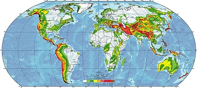
This is the Global Sesimic Hazard Assessment Program’s global hazard map:

lilworld.jpg

Andrew Alden of About.com geology has produced a nice little resource by taking the high-resolution data freely available on the GSHAP website and breaking it down into a series of regional maps. Here’s the one for Africa:

africa.jpg

Continue reading

Categories: geohazards

The Black Sea ‘flood’ and the rise of European agriculture

The Black Sea has only a tenuous connection to the rest of the world’s seawater. The Bosporus are not only very narrow, but very shallow: at one point in the channel, the water is only 30m deep. At the height of the last ice age 18-20,000 years ago, more water was stored in much larger polar ice caps and global sea-level was about 130 metres lower than at present; this is more than enough to have left the Bosporus high and dry, and the Black Sea completely cut off from the Mediterranean. Past studies of sediments dating from this time confirm that the Black Sea basin was indeed a freshwater lake, filled to about 150 metres below present day sea-level; they also indicate that there was an abrupt switch to marine conditions between 6000 and 7500 BC, when sealevel rose enough to send a torrent of marine water rushing into the Black Sea, flooding tens of thousands of square kilometres of what was, up to that point, dry land.
A catastrophic flood in Asia Minor, back in the mists of human prehistory? Cue endless twittering about certain myths in certain holy books whenever this story comes up in the media. An interesting new paper in Quarternary Science Reviews by Chris Turney and Heidi Brown is no exception. However, although their work suggests that there may be a link between this event and an important transition in European culture, it makes the (in my opinion) already tenuous alleged connection to ‘Noah’s Flood’ (there was no 40 days and 40 nights of rain. There was no rain – just 40 years of inexorably rising water as the Black Sea Basin filled up to sea-level. Even accounting for a few thousand years of distortion and exaggeration, that seems a bit of a stretch) even more difficult to support.

Continue reading

Categories: general science, paper reviews

You can…


Hearty congratulations to them both.

Categories: links

Bangladesh: young, flat, and vulnerable

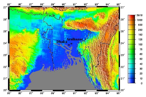
Fellow Sciblings Sheril and Chris have done a sterling job of covering the impact of Cyclone Sidr, which struck Bangladesh at the end of last week. Bangladesh is particularly vulnerable to the large storm surges generated by such events, thanks to its rather minimal topography (source – scale is in m above sea level):

Bang_topo.jpg

As you can see, a substantial proportion of the country is less than 10 metres above sea level; according to this, much of it is actually only a metre or two above. Cyclone Sidr’s winds produced a storm surge of about 5 metres, which is enough to inundate vast areas; just think how much of a gently sloping beach 1 or 2 metres of vertical tidal movement can cover and uncover . This unfortunate point is made clear by before-and-after satellite images of Bangladesh from the Earth Observatory, which show flooding 200 km or more inland from the coast.
Bangladesh is located at the confluence of numerous large rivers like the Ganges and Bramaputra, which carry vast amounts of eroded sediment down from the Himalayas and Tibet and dump it into the Bay of Bengal, forming a huge river delta – which, essentially, is all that Bangladesh is. As fast as the land is built up by sediment deposited on the flood plain, the weight of this vast orogenic spoil heap bows down the crust beneath it, causing it to subside back down again. Thus there is new fertile sediment aplenty, but in the absence of any tectonic uplift, Bangladesh stays in its precarious topographic position.

Categories: geohazards