
Fellow Sciblings Sheril and Chris have done a sterling job of covering the impact of Cyclone Sidr, which struck Bangladesh at the end of last week. Bangladesh is particularly vulnerable to the large storm surges generated by such events, thanks to its rather minimal topography (source – scale is in m above sea level):
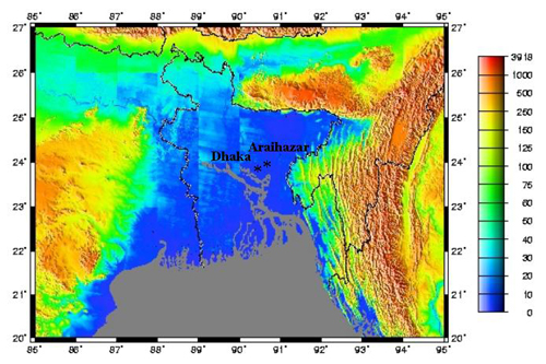
As you can see, a substantial proportion of the country is less than 10 metres above sea level; according to this, much of it is actually only a metre or two above. Cyclone Sidr’s winds produced a storm surge of about 5 metres, which is enough to inundate vast areas; just think how much of a gently sloping beach 1 or 2 metres of vertical tidal movement can cover and uncover . This unfortunate point is made clear by before-and-after satellite images of Bangladesh from the Earth Observatory, which show flooding 200 km or more inland from the coast.
Bangladesh is located at the confluence of numerous large rivers like the Ganges and Bramaputra, which carry vast amounts of eroded sediment down from the Himalayas and Tibet and dump it into the Bay of Bengal, forming a huge river delta – which, essentially, is all that Bangladesh is. As fast as the land is built up by sediment deposited on the flood plain, the weight of this vast orogenic spoil heap bows down the crust beneath it, causing it to subside back down again. Thus there is new fertile sediment aplenty, but in the absence of any tectonic uplift, Bangladesh stays in its precarious topographic position.