What is a manned space programme actually for?

A post by Chris RowanToday President Obama announced that in his next budget he was going to cut funding for NASA’s Constellation Program, and with it the plan to send people back to the Moon. This is no doubt going to lead to a lot of noisy protest; but I can’t help wondering if it isn’t the correct decision, because I was never entirely clear on what, exactly, they were going to do when they got back to the Moon beyond a “well, gee, we’re on the Moon!” and we managed that 40 years ago. In fact, the story of the Apollo program contains a salutary lesson about the consequences of gearing your space programme totally around the simple goal of reaching somewhere: once you’ve got there, that’s it.
It’s normally around this stage of an argument about manned space flight that someone plays the “inspiration” card. But I can’t remember when I was last inspired – really, truly, left awestruck – by something an astronaut did. The most exciting thing that I can recall any of them doing in the last couple of decades is fixing up the Hubble Space Telescope three times, and the inspirational bit came from what Hubble did after it had been made even better than before. Most of the time the astronauts just head up to the International Space Station, stay in orbit for a few months, and then come back home again. They take the odd pretty picture, it’s true, but what’s their primary function? Yes, we get more data on the effects of long-term zero gravity on human physiology, but are they really doing anything that wasn’t being done on Mir 15 years ago? I can’t help feeling that – much as it pains me to admit it – they’re there just so the ISS seems like a bit less of an orbiting albino pachyderm. Either way I would bet a fair sum that more people currently know the name of a valiant little Mars rover than know the names of the current astronauts on the ISS. Because Spirit has done things.
From this, you might reasonably conclude that I’m completely against the idea of sending people into space. I’m not: I’m just against the idea of doing it on the cheap. If we’re going to revisit the Moon, and go on to Mars or near-Earth asteroids, it shouldn’t be just to commit the worst form of checklist tourism – to go just so that we can say we’ve been. It should be with a purpose – with the aim of actually doing something new and interesting whilst we’re there, or at least as part of a wider strategy of establishing a useful human presence in space beyond the tiny and impotent foothold we maintain at the moment. That would be inspirational. But I suspect that it would also be much more expensive than I think we’re willing to countenance right now – and, more importantly, probably beyond our current space technology.
But perhaps I’m wrong about all this. What do you see as the point of manned space flight right now? What point do you think it could have?

Categories: general science, planets, ranting

Coal and the fossil record of climate change in the Canadian High Arctic

A post by Anne Jefferson

Coals exposed along Stenkul Fiord, southern Ellesmere Island, Canadian Arctic (Photo by Anne Jefferson)

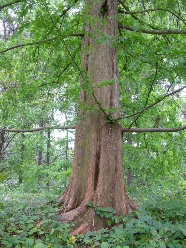
Coals exposed along Stenkul Fiord, southern Ellesmere Island, Canadian High Arctic
(Photo by Anne Jefferson)

For more than 55 million years, Ellesmere Island remained in one place while the world around it changed. Fifty-five million years ago, verdant forests grew at 75¬? North latitude. These wetland forests, [comprised] of species now primarily found in China, grew on an alluvial plain where channels meandered back and forth and periodic floods buried stumps, logs, and leaves intact. Today the forests are preserved as coal seams that outcrop on the edges …[of] modern Ellesmere Island, [where] there are no forests, and the tallest vegetation grows less than 15 cm high. Large parts of the area are polar desert, subject to intensely cold and dark winters and minimal precipitation.

These are the opening lines to my M.S. thesis, in which I contrasted the Paleocene-Eocene and modern hydrological environments of Stenkul Fiord, on southern Ellesmere Island in the Canadian Arctic Archipelago. My thesis goes on to describe a world that no longer exists, except in the fossil record preserved at sites in the High Arctic. This former world may provide clues as to how polar flora and fauna and their physical environment responded to global mean surface temperatures that were 2-4 degrees warmer than they are today, yet are right in line with the predictions for the end of this century. These clues, recorded in the fossil and stratigraphic record in coal and sediment layers on remote Ellesmere Island, well north of the northernmost civilian settlement in North America, are under attack. The same human demand for energy for that is driving up global temperatures is threatening to erase the very fossils that record polar life under a warmer temperature regime. The government of Canada’s Nunavut territory is currently considering claims by Westar Resources, Inc. to mine the coal beds in one of the most spectacular of all the fossil localities in the High Arctic.
During the Paleocene and Eocene, tropical vegetation extended to 50¬? N, and broad-leaved evergreens reached 70¬? N. There was no permanent polar ice, and large parts of the polar regions were covered by forests dominated by cypresses and angiosperms. Fossilized remnants of these forests are found in locations such as Spitsbergen, Greenland, the Yukon, northeastern Asia, and the Canadian Arctic Archipelago. This widespread Arcto-Tertiary forest nearly disappeared as the climate cooled over the past 30 million years and modern temperate forests. Today the last remnants of this flora are preserved in the mountains of China’s Sichuan province.

Modern Metasequoia glyptostroboides. Photo taken at the Tyler Arboretum where it was identified. Photo (c)2006 Derek Ramsey via Wikimedia. (Click image for usage permissions)

Modern Metasequoia glyptostroboides. Photo taken at the Tyler Arboretum where it was identified. Photo (c)2006 Derek Ramsey via Wikimedia. (Click image for usage permissions)

Among the signature trees of the Arcto-Tertiary fossil record is the Metasequoia, a genus which was thought to have gone extinct in the Miocene until an isolated grove of Metasequoia glyptostroboides, or dawn redwood, was discovered in Sichuan in 1944. Metasequoia grows to 60 m tall and unlike sequoias, it is deciduous and loses its leaves in the winter. This would have been quite handy for life in the High Arctic, where in the Paleocene-Eocene winter temperatures might have hovered just above freezing, but would still have been dark for six months of the year.
At the site where I worked on Ellesmere Island, there were large Metasequoia logs and tree stumps still rooted in situ in the coal layers. Picking apart the coal layers, I could pull out Metasequoia leaves, twigs, and male and female cones. The siltstones between the coals preserved beautiful fossil impressions of a variety of tree leaves and stems.

Metasequoia log, Stenkul Fiord, Ellesmere Island (photo by Anne Jefferson)

Metasequoia log, Stenkul Fiord, Ellesmere Island (photo by Anne Jefferson)

Metasequoia stump, Stenkul Fiord, Ellesmere Island (photo by Anne Jefferson)

Metasequoia stump in its growth position, Stenkul Fiord, Ellesmere Island
(photo by Anne Jefferson)

My field site on Stenkul Fiord yielded only plant fossils, and for now, is safe from the development plans of Westar Resources and the Nunavut government. But a bit north at Strathcona Fiord, plants are second fiddle to the best vertebrate fossil locality of the Canadian High Arctic. At Strathcona Fiord, the fossil record shows that those Eocene forests were inhabited by alligators, giant tortoises, primates, tapirs, and the hippo-like Coryphodon. There have been over 40 papers published on the Eocene fossils of Strathcona Fiord alone. It’s not just the Eocene that makes Strathcona Fiord an amazing fossil locality either. Pliocene layers at Strathcona Fiord have yielded plants, insects, mollusks, fish, frog and mammals such as black bear, 3-toed horse, beaver, and badger. It is the only known Pliocene Arctic site with vertebrate remains.

Strathcona Fiord is one of three sites where Westar Resources, Inc. plans to mine the coal. Mining the coal will permanently destroy the embedded fossils and the possibilities for any additional discoveries at this site. The other two Ellesmere Island areas in which Westar has applied for mining permits are the Fosheim and Bache Pennisulas. We don’t know as much about the paleontology of these areas, but the little work that has been done on the Fosheim Peninsula has already discovered Eocene leaf beds and Pliocene fossils.
Paleontologists and geologists around the world are raising their voices in opposition to the proposed coal mining at Strathcona Fiord and the other sites on Ellesmere Island. The Society of Vertebrate Paleontology has issued a press release expressing concern and urging the preservation of the fossils resources. There is also a coordinated letter-writing campaign to the Nunavut Impact Review Board. I’ve just sent a letter to the review board, which I’ve appended below. If you are a paleontologist, paleoclimatologist, geologist, Arctic lover, fossil lover, or otherwise moved by the incredible story of alligators and towering trees at 75° N, I urge you join me in writing to the government of Nunavut and encourage them to at least require more study of the localities before mining is approved. Letters can be sent electronically to info@nirb.ca.

To the members of the Nunavut Impact Review Board,
I appreciate the opportunity to write to you concerning the proposed Westar coal project on Ellesmere Island. I am a geologist at the University of North Carolina at Charlotte, and my research focuses on the intersection of hydrology, landscapes, and climate. My graduate M.S. thesis research focused on the paleo-environments of the Eureka Sound Group exposed at Stenkul Fiord on southern Ellesmere Island. I used the coal and sediment layers, and the fossils they contain, to understand variability of hydrological environments that existed in the Arctic 55 million years ago. Today, I work on issues of water and modern climate change, but my perspective was profoundly influenced by the time I spent on Ellesmere Island walking amidst the coal layers and fossilized tree trunks.
The proposed activities by Westar Resources, Inc. could damage or destroy fossil sites that form an important part of Nunavut’s history and environmental legacy. These fossils tell us about the history of Arctic plants and animals, and they are recognized internationally for their scientific importance. They also provide important evidence from a time when Earth, especially the Arctic, was warmer. The fossils of the Ellesmere Island sites proposed for mining by Ellesmere Island provide clues as to how polar flora and fauna and their physical environment responded to global mean surface temperatures that were 2-4 degrees warmer than they are today, yet are right in line with the predictions for the end of this century. Ultimately, I hope that evidence from Nunavut’s fossil record can help us better estimate and prepare for future climate change.
If the fossil sites in the Westar coal project areas are destroyed the evidence is lost forever, therefore I recommend that the Nunavut Impact Review Board advise the Minister, pursuant to article 12.4.4(a) of the Nunavut Land Claim Agreement, that the project proposal requires review under Part 5 or 6. I believe that much more paleontological and paleoclimatic research can be conducted at these sites before any coal is extracted from them and we lose the opportunity to learn all that we can.
I thank you for your consideration, and request that you keep me informed of the results of this screening process.

Ellesmere_timescale.png

Categories: by Anne, Cenozoic, climate science, environment, fossils, photos

Where I’ve been

A post by Chris RowanIt’s been a bit quiet around these parts since I posted on the Haiti earthquake. Those of you following me on Twitter know that at that point I was actually spending a few days exploring New York: its parks, its almost stupidly tall buildings, and its rather nifty natural history museum.

NewYork1.JPG
Central Park, in which I was a lone stroller in a sea of joggers.

NewYork2.JPG
From the Empire State Building, the rest of Manhattan looks like a model village.

AMNH1.jpg
Very cool rocks on display at the American Museum of Natural History: samples of the 4 billion year-old Acasta Gneiss (oldest known bit of Earth’s crust) and Jack Hills Conglomerate (contains oldest known, 4.4 billion year-old zircon crystals).

AMNH2.JPG
A fair amount of artistic license has gone into this particular fossil exhibit…

After that, I headed onwards to North Carolina. The chief purpose of my US visit was to attend the ScienceOnline 2010 conference, of course, but it was also a chance to catch up in person with my talented hydro-coblogger Anne Jefferson, who hails from Charlotte. I spent Friday in her department (probably totally confusing her hydrologist and geographer colleagues with a talk about the wonders of palaeomagnetism), before she drove me over to Raleigh-Durham and Sigma Xi for the conference itself.
Last year, I indulged in some conference blogging; this year Twitter served as my primary means of online note-taking. Whatever the wider value of conference tweeting, I find that two or three 140 character points from a session is enough to distil the major points, without distracting me too much from events at the podium. I also had my own Sunday morning session discussing geospatial data and other geoscience web applications to prepare for, although I fully confess that my co-convenor Jacqueline Floyd was more responsible for the coherence and value of the session than I was (and I must also give a special shout out to Cameron, Christina and the other participants for what turned out to be a good discussion in the unconferenced part of the session).
I had a good time at the conference: I especially enjoyed the sessions on promoting diversity in science (which Anne expertly helmed, and drew upon the very interesting results of the woman geoscientists and blogs survey), rebooting science journalism, reporting from the Great Pacific Garbage Patch, and Web Science (study of the web, rather than with the web). It was also nice to share a room, and great conversations, with so many online friends and colleagues: Ed, Arikia, Janet, Zuska, Brian (whose promise to send me a copy of his book I will remember!), Scicurious, Pal, KevinZ, Miriam, Bora (of course), and many, many others. However, in the aftermath Anne and I both mused over the fact that just as the boundary between new and old media (or bloggers and journalists) becomes ever more blurry, so this conference has become less of a blogger meet-up and more of a media conference, with the requisite evolution in feel and focus. I’m not passing judgement on this, although part of me (with my little niche geology blog) feels a bit left behind by this mainstreaming of the online science community. Nonetheless, this will not stop me doing my best to return next year.
The end of the conference did not mark the end of my time in North Carolina, as I persuaded Anne to spend her Martin Luther King Day on a little field trip into the foothills of the Appalachians. Fortunately our chosen destination, Caesar’s Head State Park, was well furnished with both rocks (a granitic gneiss, if you must know) to divert me, and waterfalls to appease her. Also, as the park is perched on the edge of the Blue Ridge escarpment, there were some rather fabulous views for us both to enjoy, particularly as our excursion coincided with a fabulous mini-warm spell.

P1180209s.JPG
Caesar’s Head.

P1180217s.JPG
Raven Cliff Falls

P1180210s.JPG
The view from Caesar’s Head

Sadly, my fun could not last, and by Wednesday I was back in a somewhat less sunny UK. But at least this means that some more posts may appear in the not to distant future.

Categories: bloggery, conferences, outcrops, photos

Tectonics of the Haitian earthquake

A post by Chris RowanA magnitude 7.0 earthquake struck Haiti this evening, causing extensive damage to the capital, Port-au-Prince, and probably causing many casualties. The map below shows where the main shock occurred (red), as well as the epicentres of the numerous aftershocks (orange) that occurred in the following 5 or 6 hours (and continue even as I write).

Haiti.jpg

The main shock appears to have initiated less than 25 km southwest of Port-au-Prince; this close proximity meant that the city would have endured the maximum possible shaking intensity from an earthquake of this size, leading to extensive damage. Here’s the focal mechanism, courtesy of the USGS:

Haitifm.png

With the help of my recent post on focal mechanisms, it is hopefully obvious that the rupture occurred on a primarily strike-slip fault, with the crust on each side of the fault moving horizontally relative to the other side. To understand why there is strike-slip faulting in this area, we need to step back, and look at a simplied map of the entire Caribbean:

Caribbean_plate2.png

The Caribbean is contained on its own separate little plate; a rather diminutive part of the tectonic jigsaw that is the Earth’s crust. It is surrounded on three sides by the much larger North and South American plates, both of which are moving approximately westwards with respect to the Caribbean plate at around 2-3 centimetres a year. On the eastern edge of the plate, the boundary runs perpendicular to the direction of relative plate motion, so there is compression and subduction (and subduction volcanism, exemplified by the likes of Montserrat). However, as the boundary curves around to form the northern boundary of the Caribbean plate, where the Haitian earthquake occurred, it starts to run parallel to the direction of relative plate motion, making strike-slip faulting along E-W trending faults the most likely expression of deformation in this region. This is exactly what the Haitian quake appears to record.

Note also that deformation across the northern plate boundary appears to be distributed – some motion is accommodated on faults that are located a little bit away from the actual plate boundary, further inside the plate interior. The Haitian quake appears to have occurred on one of these faults: based on the position of its epicentre the rupture is extremely close to the Enriquillo Fault, which appears to be a major strike slip fault running across the southern end of Haiti. This is the fault most likely to have ruptured.

Nj10.png
Tectonic map of the Northern Caribbean (Source)

There is nothing particularly unusual about this earthquake given the tectonic context. Unfortunately, however, Haiti is a very poor country – one of the poorest and least developed in the world – so unfortunately, its government was not in a position to really do much to prepare for the inevitable large earthquake, leaving tens of thousands to suffer the consequences.

Update from Anne: Chris has been featured in a Nature News Briefing: “The Haiti Earthquake in Depth” along with more information about the faults in question and the known seismic risk of the area.

Further updates:
Haiti’s seismic future
What next for the Enriquillo Fault?

Categories: earthquakes, geohazards, geology, tectonics

Geospatial data and the web (#scio10 preparation)

A post by Chris RowanAfter busting my gut in the last couple of weeks to put out 12 posts in 12 days – and many thanks for the positive feedback, both public and private, that I’ve received for the series – it’s now more than time to look ahead to the fast approaching ScienceOnline 2010 conference. Amongst all the fantastically interesting sessions and discussions on offer, I’m co-chairing a session with Jacqueline Floyd entitled Earth Science, Web 2.0+, and Geospatial Applications.
For people working in geology and other field sciences like oceanography and ecology, the geographic context, and the 2D or even 3D spatial distribution of our data, is often extremely important, and the ability to store, access and visualise this information using web tools is gradually developing. This therefore seems like the ideal time to get a dialogue going about how web and social media tools might be used to distribute, use, and in the latter case even generate, geospatial datasets. I am hoping with this post to get some discussion going here which can feed into the session next weekend, but Jackie and I are also hoping that the conversation will continue in the next few months, with some moves towards realising some of the ideas that seem to be floating around this subject in the geoblogging community (and beyond). We believe that the discussion can be focussed around three questions:

  • What’s available? With help from other geobloggers, I’ve been trying to compile a list of currently available geospatial datasets. Even though it’s still far from comprehensive – please feel free to suggest any additions, either on the wave, the wiki or in the comments here – it does show that quite a lot of interesting data available on the web already. However, availability doesn’t necessarily mean usability, so we’d also like your thoughts on the good, the bad and the ugly of the nascent geospatial web. By contrasting good sites where data are easily and intuitively accessed and visualised (something like ClimateWizard springs to mind), against sites where getting the data is still a bit fiddly (such as the USGS earthquake search page, which is a stark contrast to a lot of its offerings), we can try to identify ‘best practices’ which would be useful when developing geospatial resources in the future.
  • What would you like to see? What data are not available that could/should be? This could be in terms of specific datasets, or in types of data – should we be geocoding papers, blog posts, photos? In the second case, I have been playing around with this idea, but it’s still a bit ad-hoc. As a subsidiary question, there is also the issue of what other contextual tagging is required in addition to geocoding (e.g., age is just as important in many geological contexts).

  • What tools are we missing?. If the geospatial web is going to take off, we need to make more user-friendly tools to encode, access and visualise geospatial data sets, so that people not familiar with the inner workings of web protocols will use them. We need easy searching, perhaps using a graphical map interface where you can select areas you want to search for data in. We need ways of integrating different data sets into the same visualisation (perhaps through broad mash-ups like a Google Earth geology layer or the excellent, if tightly focussed GeoMapApp). And there is also the prospect of the ability to construct new geospatial databases from geotagged data harvested from the web – crowdsourcing efforts like the USGS’s Twitter Earthquake Detector, and the #uksnow twitter aggegator demonstrate two different ways of collecting data with a geospatial component. There’s probably all sorts of other data you could collect in a similar fashion: but how can we make it easy for people to submit data? What I’d like to see is some sort of generic app that makes allows you to add geocoded photos/notes/voice memos/videos/other data such as structural to a specified feed that can then be viewed on Google Maps/Earth – either a personal one for a particular field trip project or a collective one for crowdsourcing projects. Perhaps a bookmarklet for your browser that allows you to geocode things you encounter on your browsing via a map interface.
    One potential consideration here is that there may be a difference between using such data for simple sharing, and possibly using it for research. What is required to make web-harvested datasets scientifically useful? For example, how to you determine the accuracy of the location provided? How to you filter out bad or irrelevent data?

I’ll be interested to hear everyone’s thoughts and ideas – remember, even if you can’t make the session, you can still help to make the discussion more fruitful there, and give it some momentum in the aftermath.

Categories: fieldwork, general science, geology