Two tributes to Reds Wolman (1924 – 2010)

A post by Anne JeffersonM. Gordon “Reds” Wolman was a towering figure in 20th century fluvial geomorphology, fundamentally shaping our understanding of river forms and processes, profoundly influencing environmental education and river management, and educating scores of students that continue to push the boundaries of our scientific understanding of landscape and hydrologic processes.
But to say that Reds merely educated his students is an understatement, he touched our lives. Reds was my academic grandfather (my Ph.D. advisor’s Ph.D. advisor), he was my undergraduate geomorphology professor, and he was one of a small handful of people who have profoundly influenced my career.
I’ve included below a beautiful tribute to Reds Wolman, written by his friend and colleague Peter Wilcock. Below the fold, I’ve included some of my own memories of interacting with Prof. Wolman.
wolman.jpg

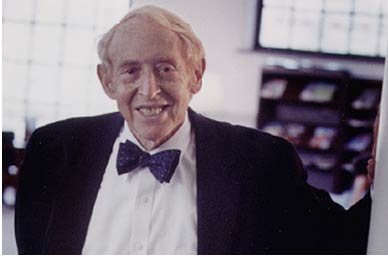
M. Gordon (Reds) Wolman
August 16, 1924 – February 24, 2010
Prof. Wolman’s career was defined by fundamental contributions to our understanding of rivers, supported by pioneering work in developing interdisciplinary environmental education and an extraordinary commitment to the application of research to river management and policy.
In his Ph.D. research at Harvard University and subsequent work with Luna Leopold at the U.S. Geological Survey, Prof. Wolman played a central role in defining rivers in a modern, quantitative and generalizable framework that still provides the standard against which new models and concepts are evaluated. The understanding and the methods developed in this work form the foundation of modern river geomorphology, engineering, and restoration. Building on this work, Prof. Wolman addressed a fundamental problem in river science: the magnitude and frequency of the processes that shape rivers and their ecosystems. Is it the rare and destructive storm that sets the size, shape and composition of river channels, or the small, persistent flows, or something in between? With his colleague John Miller, Prof. Wolman demonstrated that relatively common floods do the most work in shaping river channels and, further, that there is remarkable consistency in the frequency of these ‘effective’ floods. This result has guided interpretation of rivers and challenged river theory for the past 50 years, while also providing a key element of modern channel restoration and design. Prof. Wolman’s contribution extends to the pervasive impact of urbanization on rivers. With his colleague Asher Schick, he documented the impact of urbanization on stream channels, developing a characteristic sequence of events that defines the standard model against which impacts and remediation are evaluated.
Committed to the idea that environmental stewardship requires knowledge that is both deep and broad, Reds played a leading role–by personal example, by academic leadership at Johns Hopkins University, and by advising many academic and research programs–in defining the nature and scope of effective, rigorous, and interdisciplinary environmental education.
The link between science and society was not an abstract theme for Reds, but a path to action. Reds contributed sustained service and frequent chairmanship of National Academy Commissions, Boards, and Committees dealing with water management and policy. He also provided expert guidance to Resources for the Future, the World Health Organization, the International Scientific Committee on Problems of the Environment, the International Institute for Applied Systems Analysis, Oak Ridge National Laboratory, Savannah River Plant, and the State of Maryland among others. His indefatigable service, combined with his good-natured wisdom, influenced environmental decisions and decision-makers around the world.
For those who knew him, Reds’ professional accomplishments merely provide context for his greater personal contributions through his inspired combination of warmth, wit, and genuine affection for all he came into contact with.
The whole exceeded the sum of the parts. Reds was a distinguished scholar who played a central role in defining our modern understanding of rivers, a visionary academic who pioneered integrated environmental education, a devoted citizen who worked tirelessly to apply an understanding of rivers to their protection and wise use, and an extraordinary human being who inspired and delighted generations of students and colleagues, all friends.

Continue reading

Categories: academic life, by Anne, geomorphology

Where on (Google) Earth #185

A message from Erwin Sevens:
As a incidental visitor, wandering through geology related webpages, I stumbled upon the WoGE 184 contest. Intrigued by the beautiful phenomenon shown on the image and loving to browse around the planet with the Google Earth application, I could not resist trying to find out where it was located.
So, with a little bit of luck, I pretty quickly found the location in Bolivia. The “crater” like structure is a synclinal depression formed of Cretaceous sediments interlayered with basaltic deposits. It seems to be the place to see dinosaur tracks and a tourist attraction for hikers.
So, according the rules of the contest, it is now my turn to challenge you. Ann and Chris have kindly agreed to host.

GE_185_small.jpg
Click for a larger image

The region where I grabbed this picture is one of the many examples how aesthetically beautiful geology can be. It is taken from a eye height of 19.33 km and the top of the image is within 30 degrees of North. And no, it is not on Mars.
So, what do we see and where is it located?
Note from Chris: I think Erwin might be a little bit evil, but we’ll have to see. Although I’m tempted to waive the Schott Rule for this one, I think I’ll leave it in force for the time being. Therefore you need to wait one hour after the post time [20:45 GMT/15:45 EST) to answer for each Wo(G)E round you’ve won in the past.

Categories: geology, geopuzzling

Where on (Google) Earth #184

A message from Brian Vanderkolk:
Having won WoGE 183 I choose a location that has intrigued me personally ever since I found it while browsing Google Maps. I pick this place because I don’t have the geologic knowledge to understand what I am seeing. It appears something amazing has happened here. I hope the winner and others will help me learn something new. North is up in this picture and eye altitude is about 20 kilometers.
WoGE184.jpg
Click the image for a larger version.
Anne says: First person to identify the latitude and longitude of the image, give a place name, and take a decent stab at why it might be interesting gets the honor of hosting the next round of the game. If you are not a blogger, you can still play, win, and then designate the blogger of your choice to host your image and the next round. I’m invoking the Schott Rule, to keep giving newcomers like Brian a chance to get in on the fun. The Scott Rule, means that you need to wait one hour after the post time to answer for each Wo(G)E round you’ve won in the past.

Categories: outcrops

Stuff I linked to on Twitter last week

A post by Chris RowanFor more geo-link goodness, head over to Lockwood’s for the Flash Accretionary Wedge – you can suggest your own recent geological favourites whilst you’re there.
Demo of augmented reality maps – I can see some really cool possible geology applications for AR…
http://on.ted.com/88OU
(via @tedtalks)
Beautiful crenulated metasediments:
Plane light – http://www.flickr.com/photos/65726513@N00/3967698299/in/photostream/
Polarized light – http://www.flickr.com/photos/65726513@N00/3968476812/
(via @callanbentley)
Proposals to extend geological timescale back beyond formation of Earth. Defining GSSP will be fun!
http://www.economist.com/world/international/displayStory.cfm?story_id=15207606
(via @bobreturns)
A "history" of the climate wars, written from the vantage point of the future by Spencer Weart: by Excellent
http://dotearth.blogs.nytimes.com/2010/02/12/a-historian-looks-back-at-the-climate-fight/
(via @BoraZ, @Revkin)
Easterbrook on the quality of #climate science code ?p=1388
http://www.easterbrook.ca/steve/?p=1388
(via @thirstygecko, @scottstgeorge)
Maps of global fatal landslides
http://daveslandslideblog.blogspot.com/2010/02/maps-of-global-fatal-landslides.html?utm_source=twitterfeed&utm_medium=twitter
(via @Geoblogfeed)
Hawaii Lava Flows – ASTER Image Gallery [satellite thermal images of lava entering sea]
http://redux.com/f/993571/Hawaii-Lava-Flows-ASTER-Image-Gallery
(via @geographile, @Marscryovolc)
Waves from California collapse ice shelves in Antarctica? ["infragravity waves"? How Dr. Evil.]
http://scrippsnews.ucsd.edu/Releases/?releaseID=1046&pass=862808
(via @carlzimmer)
Video: Saturn’s auroras captured by Hubble space telescope
http://www.guardian.co.uk/science/video/2010/feb/11/hubble-space-telescope-saturn-auroras
(via @guardianscience)
Ediacaran oceans v chemically stratified & dynamic Based on Doushantuo in S China; but is it representative?
http://www.eurekalert.org/pub_releases/2010-02/uoc–npo020810.php
Sparks fly in Sakura-jima eruption [wow – lava fountains with added lightning!]
http://volcanism.wordpress.com/2010/02/11/sparks-fly-in-sakura-jima-eruption/
(via @volcanismblog)
Finding a Secret Map to Erosion [cosmogenic isotope levels in sed -> timescale of erosion. Cool!]
http://www.uvm.edu/~uvmpr/?Page=News&storyID=16008
(via @RonsGeoPicks)
Excellent piece on macroeconomics of climate policy. The "invisible hand" seen without clothes: by
http://www.grist.org/article/2010-02-10-economics-cage-match-stavins-minimalism-houser-full-court-press/
(via @ericmjohnson, @drgrist)
People vs. the Rover [cool N Mexico volcanic outcrops, thoughts on limitations of robot geologists]
http://www.iapetusbeat.com/2010/02/people-vs-rover-and-some-new-mexican.html
(via @Geoblogfeed)
Haiti as a Metaphor Haiti eq "surprise" despite warnings, other looming earth/environmental disasters may be same?
http://serc.carleton.edu/earthandmind/posts/haitimetaphor.html
Are we running out of materials? Once again, economists claim civilisation can break The Physical Laws of the Universe
http://timesonline.typepad.com/science/2010/02/out-of-this-world-are-we-running-out-of-materials.html
(via @TimesScience, )
Using Earthquakes & Magma Viscosity to Predict Eruptions? More viscous->longer ‘run-up’
http://geology.com/press-release/forecasting-volcanoes/
(via @geographile, @GeologyDotCom)
Bird-from-dinosaur theory of evolution challenged
http://www.sciencedaily.com/releases/2010/02/100209183335.htm
More than the view of one scientist? Perhaps not
Future earthquake risk in Haiti Nice interpreted SAR image. Rupture didn’t break surface, significant thrust component.
http://www.sciencedaily.com/releases/2010/02/100209152237.htm
A TREE RING RECORD FROM DEEP SEA OFF OF ANTARCTICA Wow, 1"/year deposition rate, seasonal banding.
http://joidesresolution.org/node/1098
(via @Geoblogfeed)
[Lots and lots of!] Dust over Iran
http://earthobservatory.nasa.gov/NaturalHazards/view.php
(via @NASA_EO)
Fabulous! : Soufriere Hills puts on night-time pyroclastic flow show
http://www.swisseduc.ch/stromboli/perm/montserrat/pyroclastic-night-en.html
(via @volcanismblog)
Wired: Stunningly Preserved 165-Million-Year Old Spider Fossil from China ‘Stunning’ well earned in this case.
http://www.wired.com/wiredscience/2010/02/spider-fossil/
UK spring: 1976-2000, timing of reproduction and population growth >11 days earlier, change accelerating
http://www.eurekalert.org/pub_releases/2010-02/cfe-wes020510.php
Techno-Archaeology Rescues Climate Data from Early Satellites – might extend sea ice record back to 60s.
http://nsidc.org/monthlyhighlights/january2010.html
(via @Eaterofsun)
Blood iPhones? [or, more specifically, blood tantalite/niobite]
http://lablemminglounge.blogspot.com/2010/02/blood-iphones.html
(via @Geoblogfeed)
Defusing the Methane Timebomb methane munching bacteria may eat results of clathrate breakdown.
http://www.scientificamerican.com/article.cfm?id=defusing-the-methane-time-bomb
(via @Eaterofsun, @Mims)
Hmmm. A new addition to my excursion list? : Laacher See: The caldera in the middle of Europe
http://scienceblogs.com/eruptions/2010/02/laacher_see_the_caldera_in_the.php
(via @Geoblogfeed)
Tafoni Occurs In Basalts Too [Tafoni=ellipsoidal weathering features, but I’m sure you knew that]
http://suvratk.blogspot.com/2010/02/tafoni-occurs-in-basalts-too.html
(via @Geoblogfeed)
Drought in SW Australia linked to increased snowfall in Antarctica A "precipitation see-saw"
http://www.physorg.com/news184771509.html
Nice interview: Lamont Seismologist answers question on #Haiti #earthquake
http://www.physorg.com/news184488365.html
New paper lists quakes that have caused most ground shaking. High magnitude does not always -> most shaking, damage.
http://www.sciencedaily.com/releases/2010/02/100205102550.htm
A Landscape Created by the Earthquake of 1700, Washington State.
http://washingtonlandscape.blogspot.com/2010/01/washington-state-coast-is-located-along.html
(via @RonsGeoPicks)

Categories: links

Where on (Google) Earth #183

A post by Anne JeffersonI won the Where on (Google) Earth contest #182, hosted by Dr. Jerque at Geologic Frothings, by correctly identifying the location near Aktash, Altai Republic, Russian Federation. At that spot, some intriguing geomorphic stuff happened once upon time. More specifically, starting in these mountains, spectacular Pleistocene ice-dam failure megafloods raced across the Asian continent eventually reaching the Caspian, Black, and Mediterranean seas. Discharge from these floods is estimated to rival, or even exceed, the Missoula Floods. The location Dr. Jerque put in the spotlight is close to one of the ice dams, has some absolutely spectacular ripple fields, and is just upstream of an amazing gorge created by water rushing up to 45 m/s (162 km/hr, 100 mi/hr). There’s a really nice write-up of the floods, with on-the-ground photos, that can be found here.
Having just searched out one of the most jaw-droppingly powerful geomorphic spots on Earth, I’ve opted to go for something a bit more subtle for Where on (Google) Earth #183. Nonetheless, I think there’s something geo-interesting going on in this image. The eye altitude here is ~15 km and the vertical exaggeration on my browser was set to 2.
woge183-500.jpg
Click the image for a larger version.
First person to identify the latitude and longitude of the image, give a place name, and take a decent stab at why it might be interesting gets the honor of hosting the next round of the game. If you are not a blogger, you can still play, win, and then designate the blogger of your choice to host your image and the next round. I’m invoking the Schott Rule (sorry, Ron), which means that you need to wait one hour after the post time to answer for each Wo(G)E round you’ve won in the past.

Categories: by Anne, outcrops