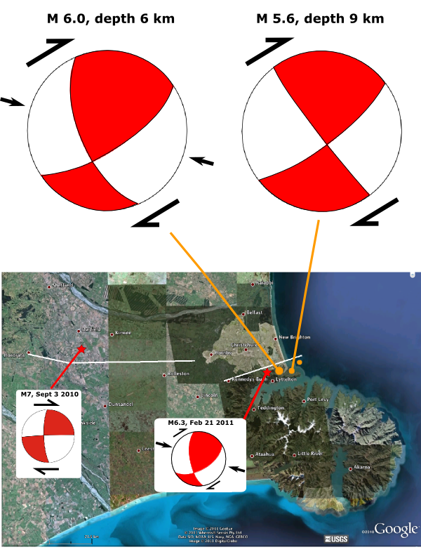
![]() Poor Christchurch just can’t seem to catch a seismic break this year: two more powerful aftershocks shook the city early Monday afternoon local time: the first a magnitude 5.3 (Geonet, USGS), the second a magnitude 6 (Geonet, USGS). The focal mechanisms of both shocks indicate mostly pure strike-slip motion, probably dextral strike-slip along a northeast-southwest oriented fault plane; the M6 quake also has a component of roughly east-west compression. These focal mechanisms are very similar to the magnitude 7 Darfield earthquake last September and the magnitude 6.3 rupture that badly damaged the city in February. These latest tremors occurred a few kilometres to the east of February’s quake, and from their location and the manner in which they ruptured, it looks like these earthquakes were on another, more easterly segment of the same fault.
Poor Christchurch just can’t seem to catch a seismic break this year: two more powerful aftershocks shook the city early Monday afternoon local time: the first a magnitude 5.3 (Geonet, USGS), the second a magnitude 6 (Geonet, USGS). The focal mechanisms of both shocks indicate mostly pure strike-slip motion, probably dextral strike-slip along a northeast-southwest oriented fault plane; the M6 quake also has a component of roughly east-west compression. These focal mechanisms are very similar to the magnitude 7 Darfield earthquake last September and the magnitude 6.3 rupture that badly damaged the city in February. These latest tremors occurred a few kilometres to the east of February’s quake, and from their location and the manner in which they ruptured, it looks like these earthquakes were on another, more easterly segment of the same fault.

Focal mechanisms and locations for the two large June 13 aftershocks, compared to the September 2010 and February 2011 ruptures. White lines are rough fault traces.
Fortunately, there appear have been few casualties this time around, but a new violent tremor is not good news for the many already damaged buildings in Christchurch. Peak ground accelerations from the M6 shock were quite high in the southern parts of the city (0.7-0.8g mostly, although one instrument recorded a 2.1g acceleration). The BBC reports that several buildings have collapsed, and there have also been further rockfalls, perhaps from cliffs already weakened by the previous earthquakes. Once again, the shaking has also caused extensive liquefaction in Christchurch and its suburbs, exacerbating the damage and destruction.
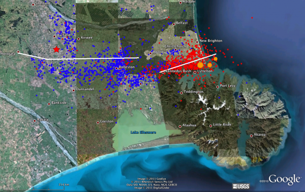
A clear thread running through many of the reports and interviews that I’ve been reading today is that the residents of Christchurch are fearful and fed-up with what is turning into a year of misery – and you can hardly blame them for wondering if they shouldn’t just give up and move. The risk of further large aftershocks is still present, of course, but one clear trend since the Darfield earthquake last September is that seismic activity is migrating east over time. The mainshock and aftershocks of February’s earthquake (the red circles in the figure below) are to the east of the Darfield mainshock and aftershocks (blue circles), and yesterday’s earthquakes (orange circles) are further east still. The whole fault system seems to be progressively unzipping from west to east, and the locus of seismic activity has now moved past Christchurch and is heading out to sea. The earthquakes may not stop right away, but at least they’ll probably be further away – and will therefore cause less damage.

Aftershocks of the September 2010 Darfield earthquake (blue), the February 2011 earthquake closer to Christchurch (red), and the biggest earthquakes on June 13 (orange). Click for a larger version. Data from Geonet.
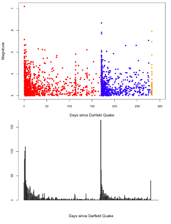
Also, whilst it may be happening far slower than everyone would like, the seismic activity is slowly dying down. In the top figure below I’ve plotted the magnitudes of all of the earthquakes with a moment magnitude larger than 3 that have been detected around Christchurch since the Darfield earthquake last September; in the bottom figure I’ve plotted the number of earthquakes per day. There is a clear sawtooth pattern: the magnitude and frequency of the aftershocks decayed as expected following the Darfield quake, until February’s magnitude 6.3 tremor. This triggered a whole new flurry of activity, but note that the peak magnitudes are lower in this cycle, and the aftershock frequency decays more quickly. Yesterday’s events have temporarily boosted seismic activity again, but (as far as you can tell from limited data so far) to a still lesser degree.

Magnitude and Frequency of earthquakes near Christchurch since September 2010 Darfield Earthquake. Data from Geonet.
So, whilst the immediate seismic risk has by no means abated for the citizens of Christchurch, hopefully the worst is behind them.


Comments (23)
Links (4)
-
-
-
-
Pingback: A fresh temblor in the Canterbury sequence « The Trembling Earth
Pingback: Tectonics of the M7 earthquake near Christchurch, New Zealand | Highly Allochthonous
Pingback: Stuff we linked to on Twitter last week | Highly Allochthonous
Pingback: Update: Christchurch aftershocks | Highly Allochthonous