
![]() This post was written in response to the Darfield earthquake in September 2010. The most recent seismic activity is discussed here.
This post was written in response to the Darfield earthquake in September 2010. The most recent seismic activity is discussed here.
[Updated 8th September 1200 GMT – see bottom of post. And check out the PodClast discussion of this earthquake, featuring Kiwi Chris Town, Ron Schott, and myself.]
The South Island of New Zealand has just been shaken by a large earthquake, reported as a magnitude 7.0 by the USGS. It appears to be quite a shallow rupture, on the Canterbury Plains close to Christchurch, and the focal mechanism indicates largely strike-slip motion.

Focal mechanism of September 3rd earthquake, and it's location with respect to the plate boundary in New Zealand
As the figure above illustrates, New Zealand is not just located on top of the boundary between the Pacific and Australian plates: it is located at a point where the nature of that plate boundary changes in some rather fundamental ways. The subduction zone running down the East Coast of the North Island terminates off the Northeast coast of the South Island, about 100 kilometres north of Christchurch, and gives way to a transform boundary cutting through the continental crust of the South Island, where the plate motions are accommodated by largely dextral strike-slip on the faults of the Marlborough Fault Zone (MFZ in the figure above) and the Alpine Fault (AP). Whilst this latest rupture clearly occurred some way south of both of these fault systems, the focal mechanism can be interpreted as showing as dextral strike-slip on an east-west oriented fault, suggesting that it is still linked to deformation at the plate boundary.
New Zealand is a region of distributed deformation: the relative motions between the Australian and Pacific plates are not accommodated on one or two faults in a narrow zone, but on many faults across a much wider zone. It is therefore perhaps not surprising to observe large earthquakes accommodating plate motions some distance from where the two plates actually meet. However, the occurrence of such earthquakes in this particular region of the South Island is probably also linked to ongoing changes in the nature of the plate boundary at the junction between the subduction zone and the continental transform. If you look at the displacement history of the individual faults in the Marlborough Fault zone, the northern faults are older, were more active in the geological past, and have quite small recent (in the geological sense of ‘the last few 100,000 years’) displacements; the southern faults are younger, and have much larger recent displacements. The most obvious explanation for these changes is that the most northern of the Marlborough faults was originally directly linked with the end of the subduction zone, but that these two structures moved out of alignment as the subduction zone moved south, causing new strands of the Marlborough Fault system to grow in order to more efficiently accommodate plate motions.

Growth of new plate boundary faults on the South Island of New Zealand in response to southward propagation of the subduction zone
This tectonic evolution is ongoing, and since the end of the subduction zone is now actually to the south of the southernmost and youngest of the Marlborough faults. Some of the plate boundary deformation is probably therefore being shunted into the region around Christchurch, where it needs to be accommodated by dextral strike-slip faulting. Eventually, over geological time, this deformation will lead to the formation of a new, more southerly strand of the Marlborough Fault system. It also means that earthquakes of this type of size are unlikely to be a one-off event in this area. Unsurprisingly, then, seismic surveys have identified a number of active faults beneath the recent sedimentary cover on the Canterbury plains (although they were identified in the linked study as reverse faults accommodating compression, strike-slip deformation is very difficult to identify if you only have a 2 dimensional cross section to work with).
Whilst this map of large historic earthquakes in New Zealand shows that earthquakes of this magnitude can occur pretty much anywhere in New Zealand, seismicity in this particular area has some particular hazards; it is close to a heavily populated region (Christchurch) built mainly on unconsolidated Quaternary sediments, which will intensify the potential shaking and damage to unreinforced buildings. Fortunately, whilst this earthquake appears to have caused a fair amount of damage, from the early reports casualties seem to be light.
Update: 4/9/10 Here’s a couple more plots to that help to further put this earthquake in context. Via GeoNet, here’s a plot of all the earthquakes in New Zealand over a ten year period, including magnitude 3 and 4 tremors that only really disturb seismometers. This gives us a much more complete picture of how the crust in New Zealand is deforming, and shows us that yesterdays earthquake occurs towards the edge of, but still within, a zone of distributed plate boundary deformation on the northeast South Island.

The historical seismicity map from the USGS shows that in the last couple of decades there were a couple of earthquakes with very similar strike-slip focal mechanisms a bit further to the north-west, closer to the actual plate boundary, with magnitudes of around 6-6.5.

>M 5 earthquakes on the South Island since 1990. Source: USGS
Some other useful links:
- Photos of damaged buildings and roads in and around Christchurch. There’s some fairly significant ground movements on display here.
- An interview on New Zealand TV with Canterbury University geologist Mark Quigley, who provides an eyewitness account of the earthquake as well as some tectonic background.
Update: 5/9/10 More useful links:
- New Zealand geologists have already identified a 13km fault trace with 3-4 m of right lateral, strike-slip offset, and variable vertical movement of up to 1 m. Follow the link for more photos.

- There are indications that there may have been multiple ruptures during Friday’s event, which could either be due to sequential failure of adjacent strands of the same fault, or possibly instantaneous triggering of nearby faults. The linked article is a bit confused, but seems to be suggesting there was a magnitude 5.8 foreshock, followed within seconds by a main shock with 2 distinct pulses. It will probably take a while to definitively untangle the sequence of events.
- GeoNet’s shakemap also has access to instrumental readings of the shaking (via the pull-down in the top right-hand corner).
- Over on sciblogs.co.nz, Chris McDowell has produced a cool Google Maps visualisation of the last few days’ seismic activity around Christchurch, which has also been turned into an animated gif (source)

Mainshock and aftershock sequence
- A summary of the earthquake by another NZ science blogger, David Winter, included a nice explanation of how shaking and liquefaction of unconsolidated sediments can produce sand and mud volcanoes, which seem to have popped up on streets and in gardens all over Canterbury.
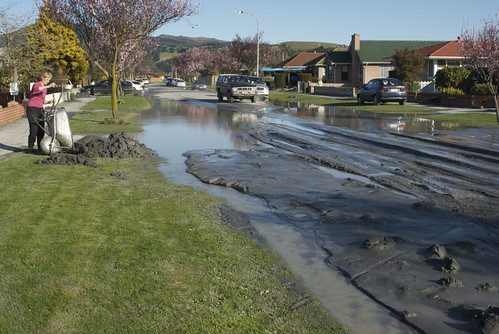
Photo by Jon Sullivan, on Flickr
Update: 6/9/10
- New Zealand geologists have been doing a sterling job of getting good information out to the public. In this press release from New Zealand’s Science Media Centre, Professor Euan Smith of Victoria University in Wellington has done a great job of describing the quake (he thinks that we’re looking at sequential ruptures of the same fault) and the seismic hazard going forward.
- The British Geological survey have put out a bulletin (pdf) that includes a plot of every >M 6 earthquake since 1843 – which must be pretty much the entire historical record.

Magnitude 6+ earthquakes in New Zealand since 1843. Source: BGS
The most striking feature of this map is the section of the Alpine fault in the central South Island that has not ruptured in the last couple of centuries – which suggests there might be a fair amount of strain belt up waiting to be released.
- There is a Christchurch earthquake group on flickr, with a good collection of earthquake damage photos.
- For those interested in learning more about liquefaction, this (pre-quake) poster from Environment Canterbury (pdf) gives both general background and a hazard map for the whole region – it would be interesting to see how it matches up to the reality.
- New Zealand’s GNS have posted a video of their survey of the fault surface rupture on their YouTube channel.
- GNS have also been calculating the focal mechanisms for all of the past weeks’ aftershocks. The pattern of strike-slip to the east of the main shock and compression to the west is quite interesting. Thanks to commenter Lanthanide for the link.
- Many people, myself included, have contrasted the Canterbury earthquake with the Haiti earthquake as an illustration of how poverty, and the consequent lack of building standards or preparedness, contributed to large differences in the damage and casualties. This is certainly an important point, but via Andy Revkin on Dot Earth, a comparison of the shaking intensity and population exposure for these two earthquakes should caution us about pushing the comparison too far. [Update: As is discussed in the comments, this USGS chart seems to underestimated the intensities in New Zealand: Christchurch, for example, is more like a VI-VII than a V. Nonetheless, the point still stands.]

Comparison of shaking intensity and population exposure for Canterbury and Haiti earthquakes. Source: USGS, via Dot Earth
Comments (26)
Links (4)-
-
-
-
Pingback: References: Earthquakes & Tsunami: Current Events & Local Hazards | GeoMika
Pingback: More large aftershocks rattle Christchurch: will it ever end? | Highly Allochthonous
Pingback: quake map | Daffnet
Pingback: After the (blog)storm: following up on the big geological stories of 2010 | Highly Allochthonous