![]()
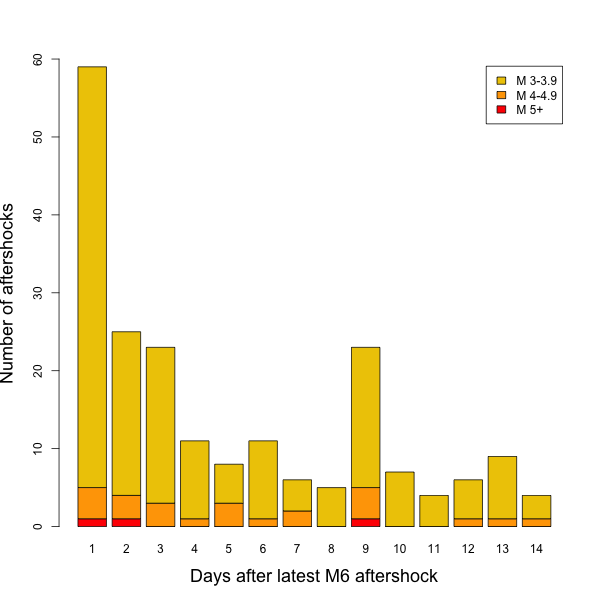
![]() It’s now been two weeks since Christchurch got its last big shake. Since then, New Zealand seismometers have registered around 200 further shocks of magnitude 3 or greater. Most of these occurred in the first 4 or 5 days following the magnitude 6 on the 12th June: activity is dying away in the expected roughly time-inverse manner.
It’s now been two weeks since Christchurch got its last big shake. Since then, New Zealand seismometers have registered around 200 further shocks of magnitude 3 or greater. Most of these occurred in the first 4 or 5 days following the magnitude 6 on the 12th June: activity is dying away in the expected roughly time-inverse manner.
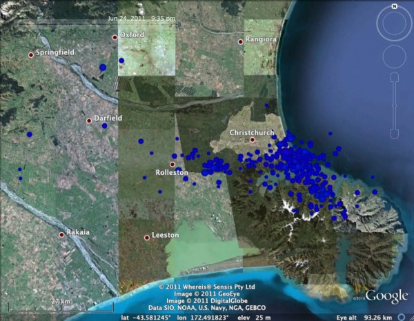
If we plot the latest pulse of aftershocks on a map (data courtesy of Geonet) they plot mainly on the Banks Peninsula to the southeast of Christchurch.
Most of the faults in this area are probably fractures around the main vent. If so, the peninsula may be acting as a sort of seismic sponge, with the strain pushed into the area by the ruptures near Christchurch being absorbed by aftershocks on lots of small fault segments, rather than there being a large thoroughgoing structure that could release all the strain in one go. It certainly seems that after a reasonably active week following the June 12 quake, seismic activity on the Bank’s peninsula seems to have faded away almost completely.
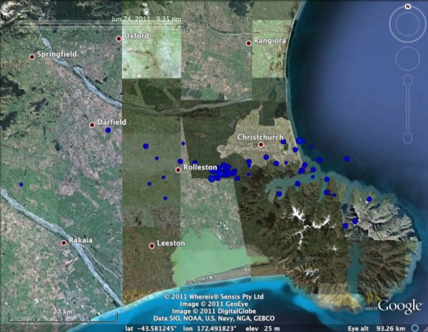
Location of >M3 quakes around Christchurch quakes between 19 and 24 June. Note the relative lack of activity on the Banks Peninsula compared to 12-19 June. Data from Geonet.
I should just add here that there is no risk of this triggering an eruption of the very, very extinct volcanoes that form the Banks Peninsula. There is no magma chamber beneath these volcanoes any more, and hasn’t been for millions of years, so there is nothing for all of this seismic activity to disturb, or trigger, or awaken.
A more pertinent question for the residents of Christchurch is: are we going to get hit by another magnitude 6+ in the next few months? There is, sadly, no way of knowing for sure. The seismic activity on and around the Darfield and Port Hills faults since last September has probably dissipated much of the tectonic strain built up on them in the thousands of years since they last ruptured. But there is a fair amount of uncertainty about this, because we don’t know the past history of these faults: we don’t know how long it’s been, exactly, since they last ruptured, or how much strain has built up on them since then.
Nonetheless, probably the biggest worry going forward is not the faults we know about, but the faults we might not know about, hidden beneath the Canterbury plains. Dr Mark Quigley, the University of Canterbury geologist who has made a habit of popping up on New Zealand TV after the latest earthquake to provide clear explanations of what’s going on, discussed in his latest appearance (and on his website) a potentially analogous situation from a region near the San Andreas Fault in California, where a large earthquake (the magnitude 7.3 Landers earthquake) and 2 associated magnitude 6+ events in 1992 were followed seven years later by a large earthquake on a nearby, parallel, fault segment (the magnitude 7.1 Hectors Mine Earthquake). As the maps below show, these earthquakes were on parallel faults subsidiary to the main branch of the San Andreas Fault, about 20 km (15 miles) apart (the red lines in the top map mark historically active faults, courtesy of the USGS).
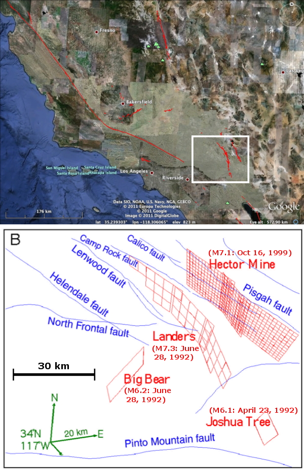
The relative locations of the 1992 Joshua Tree/Landers/Big Bear earthquakes, and the 1992 Hectors Mine Earthquake. Top map created using USGS Quaternary Faults Database; bottom map from Parsons & Drager 2000.
The link between these two earthquakes is discussed in this paper, published in 2000 by Tom Parsons of the USGS and Douglas Dreger of UC Berkeley. Their calculations of permanent stress changes following the Landers earthquake indicate that this is a case of earthquake triggering : deformation of the crust around the Landers rupture slightly increased the stress on parts of the neighbouring fault that ruptured in the Hectors Mine earthquake 7 years later, and the sections of the fault where the stress was increased the most were also the sections that slipped the most in 1999.
So, could a similar situation be possible near Christchurch? The tectonic situations are certainly broadly similar; we have subsidiary faults to a major strike-slip plate boundary (the Alpine Fault). But what we don’t know is if the Darfield and Port Hills faults have tectonic near-neighours: other faults with long seismic cycles of thousands of years, that are close enough to potentially be influenced by the recent seismicity. The answer to this question is hidden beneath the thick recent sediments of the Canterbury Plain, which extend more than 30 kilometres north and south of Christchurch.
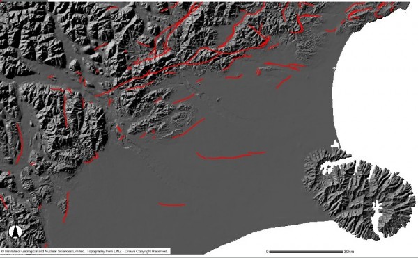
Known active faults in the Christchurch region, based on historical seismicity and geological evidence for recent motion. Source: GNS.
We know that there are some basement faults in this region, but with new seismic and gravity surveys, New Zealand geologists hope to more firmly identify the faults that have disrupted overlying sediments in the past 10-20,000 years, and are therefore active, and those that have not, so are inactive. Once active structures have been identified, we can calculate whether the regional stress changes caused by the recent earthquakes have increased or decreased the risk of a rupture in the near future. The continuing seismicity might also provide some clues: an interesting observation from the Parsons and Drager paper was that in the years between 1992 and 1999, there were a number of small earthquakes clustered around the eventual Hectors Mine rupture. Such activity is not predictive of larger earthquakes, but small quake clusters may help to identify weak points in the crust worthy of further investigation.
So, there is still a fair amount of uncertainty; to be honest, even with all the data currently being collected, we will never have complete knowledge of the seismic risks facing Christchurch in the decades ahead. But the more we know, the better informed the people of Christchurch will be, as they make choices over how and where to rebuild.
Parsons, T., & Dreger, D. (2000). Static-stress impact of the 1992 Landers earthquake sequence on nucleation and slip at the site of the 1999 M=7.1 Hector Mine earthquake, southern California Geophysical Research Letters, 27 (13) DOI: 10.1029/1999GL011272



Comments (7)
Links (1)
-
Pingback: ResearchBlogging.org News » Blog Archive » Editor’s Selections: Proving the Unprovable, Energy from Carbon Dioxide, and The New Zealand Earthquakes