Stuff we linked to on Twitter last week

A post by Chris RowanA post by Anne Jefferson

Blogs in motion and drawing attention to women science bloggers

Earthquakes

Planets

(Paleo)climate

Water

General Geology

Fossils

Interesting Miscellaney

Categories: links

All quiet on the Alpine Fault?

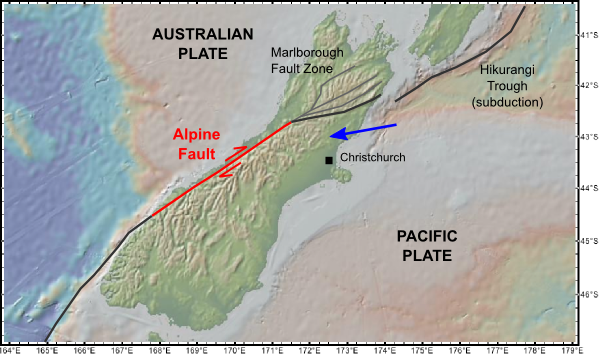
A post by Chris RowanResearchBlogging.org The question of whether the Darfield earthquake was a ‘surprise’ depends greatly on how you look at it. The fact that Christchurch was shaken up by an earthquake was not a surprise at all, given that New Zealand is neatly bisected by a plate boundary.

The Pacific-Australian plate boundary on the South Island of New Zealand.

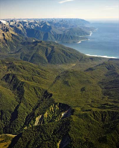
However, the precise location of the earthquake on 3rd September was perhaps a bit more surprising, given that the most obvious manifestation of the plate boundary on the South Island is not on the Canterbury Plains, but in the western foothills of the Southern Alps. Just like the Tetons, the steep western face of this range is effectively the scarp formed by several million years’ worth of motion on the Alpine Fault, and the 20 km or so of vertical motion pales in comparison to the several hundred kilometres of lateral motion between the Australian and Pacific plates that has been accommodated on this structure in the last 30 million years or so.

The southern end of the Alpine Fault. Source: Te Ara

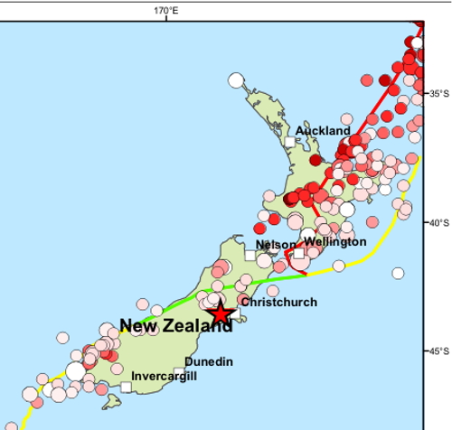
Despite its obvious tectonic significance, the Alpine fault has not ruptured since European settlement in the 1840s. In fact, it’s quite the opposite: a map of all significant earthquakes in the past couple of centuries reveals a notable lack of seismic activity compared to the rest of the plate boundary region.

Magnitude 6+ earthquakes in New Zealand since 1843. Source: BGS

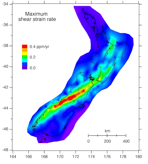
However, GPS measurements of present day deformation show that a large amount of elastic strain is constantly building up on the eastern side of the Alpine Fault, which will eventually have to be released by a rupture of the fault. The only question is, when?

Strain (deformation) rates in New Zealand, from ~10 years of GPS measurements. Source: GNS

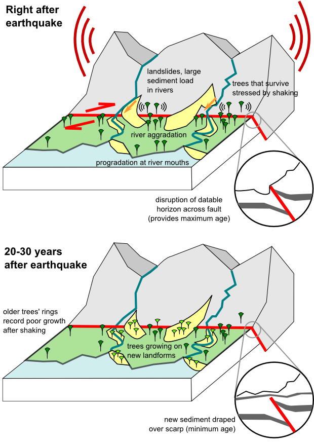
The lack of a historical record for the Alpine Fault means that we must instead examine the geological record left by past ruptures. The most direct way to do this is by digging a trench across the fault zone itself, and carbon dating organic rich sediment layers that have been disrupted as the fault breaks through to the surface – a displaced layer provides a maximum age for the earthquake (it must have occurred after the sediment was deposited); an undisturbed layer draping across a scarp provides a minimum age. However, this is not the only effect of a large earthquake in a steep, mountainous region like the Southern Alps. It will also trigger landslides, which not only reshape the landscape in their own right, but dump huge amounts of sediment into the rivers running down from the mountains. As soon as the rivers reach level ground and slow, much of this sediment will be deposited, causing the river to build upwards – a process known as aggradation. But some of the excess sediment does make it all the way to the coast, causing the shoreline to prograde – grow outwards – around the river mouth.

How past earthquakes leave their mark on the landscape and vegetation.

The important thing is that all of these new landforms can be dated. Ages can not only be estimated from carbon dating of the sediments directly beneath aggradation and progradation surfaces, but also by dating the trees growing on top of them. An earthquake on the Alpine Fault sweeps away old forest and creates large tracts of clear ground for new vegetation to spring up upon. Tree ages in this entire region are therefore clustered around the times of major earthquakes. Even the trees that have survived an earthquake will bear the scars of the shaking, in the form of periods of poor growth recorded in their rings.

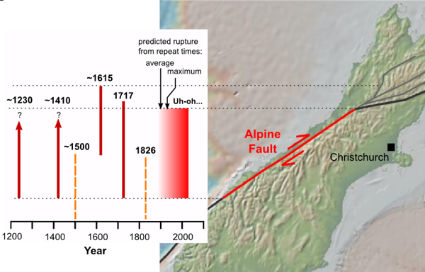
By combining all of these sources, New Zealand geologists have been able to piece together the timing of earthquakes on the Alpine Fault. A 2007 paper by Andrew Wells and James Goff further refined previous studies by looking in detail at the ages of coastal landforms, and provides the most up to date summary of the paleoseismic record. There appear to have been six distinct episodes of shaking in the last 1000 years, with estimated dates of 1230, 1410 and 1500 (older studies appear to have combined these two into one episode with an estimated date of 1460), 1615, 1717 and 1826. Four of these episodes – 1230, 1410, 1615 and 1717 – have been identified in trenching studies, so are definitely due to ruptures of the Alpine Fault. Furthermore, trench ruptures, landslides, and new fluvial and coastal landforms associated with these earthquakes are found all along the Alpine fault, suggesting that a substantial length – 3 or 4 hundred kilometres – of the whole active structure ruptured in one go, generating a magnitude 8+ earthquake. The other two shaking episodes in 1500 and 1826 only seem to have affected the southern part of the Southern Alps, and no evidence of a rupture has yet been found in trenching studies; this suggests that they may be due to earthquakes on the adjacent Puysegur subduction zone on the Fjordland coast. From these data, the average repeat time of the four confirmed ruptures of the Alpine Fault is around 160 years, and the maximum gap between ruptures is about 200 years. The last confirmed rupture, in 1717, was almost 290 years ago. The math is hardly reassuring, is it?

Past ruptures on the Alpine Fault (red lines) as estimated from paleoseismological studies. Both the average and maximum known recurrence interval were passed in the first half of the 19th century. The orange dashed lines denote events that probably occurred on the subduction zone to the south.

Note that I have refrained from using words like ‘overdue’. Whilst it’s certainly true that we are currently at the wrong end of the longest known period between ruptures on the Alpine Fault, we need to bear in mind that from a geological perspective, our record is still woefully short – there is no way of knowing if the last millennium accurately reflects the long-term seismic behaviour of the fault. There could be periods of activity separated by longer periods of relative quiescence, for example. That said, from what we do know, there will be a large earthquake on the Alpine fault in the not-too-distant geological future, and it would be no surprise if it happened tomorrow. It would also be no particular surprise if it didn’t happen for another 50 years; unlike we impatient humans, a fault would hardly know the difference.

As for the impact of such an event on New Zealand: well, Christchurch would certainly get shaken up, but perhaps not much more than it was a couple of weeks ago, due to the greater distance from the Alpine Fault. Settlements on the west coast like Greymouth and Hokitika would be far more severely affected; roads and railways across and along the Southern Alps could be destroyed; and there must be some risk of damage to some of New Zealand’s many hydroelectric dams, which are a significant contributor to the country’s overall generation capacity. Fortunately, as the past couple of weeks have shown us, the Kiwis are neither ignorant of these risks, nor unprepared for them.

Wells, A., & Goff, J. (2007). Coastal dunes in Westland, New Zealand, provide a record of paleoseismic activity on the Alpine fault Geology, 35 (8) DOI: 10.1130/G23554A.1

Categories: earthquakes, geohazards, geology, geomorphology, tectonics

A day in Anne’s life

A post by Anne JeffersonOn Twitter, JacquelynGill has called for today be a celebration of women in science (Twitter search:#womeninscience), with instructions to “Tweet and blog your favorite women scientists, introduce yourself, share resources, etc.” On top of this, I’ve not forgotten my exhortation that geobloggers should do a better job of sharing what our daily work life is really like, so that prospective geoscientists can get a better sense of what their career options might include. These two themes come together nicely, if you’ll indulge me in some almost live-blogging of my day today. When I get up to date, I’ll hit post and then I’ll update later as the rest of my day unfolds.

By the time I arrive in my building, just before 9 am, I’ve been up for about 4 hours. During that time, I have written a few paragraphs of a grant proposal, made breakfasts and bag lunches, walked the dog, talked about sunrises, great blue herons, and tadpole development with my 3.5 year old, and dropped her off at school. I’ve finished most of two cups of tea, but I always find it incredible how I can have been up so long, yet just be starting my work day.

From 9-9:20, I returned some field gear to my lab from some work I’d done last week, returned a book to a colleague, and gotten my computer to boot up. But then it was time to head down to class – I am indulging this semester in sitting in on a class on Stream Ecology, two mornings per week. Stream ecology is quite relevant to my hydrology work, and I’m increasingly collaborating with ecologists and biogeochemists, so it was time to formalize some of what I think I know about it. So far, it’s been a good addition to my undergraduate and graduate course work in biology, ecology, biogeography, and geobiology, but I really wish we had a lab, because I want to play more with the bugs in their natural environment.

Thus, from 9:30 to 11, I took notes on the nitrogen cycle (always fascinating, so complicated!) while managing to type another paragraph or two of the proposal, which is due Friday. Before and after class, I checked in with two of my grad students, who are also taking it, and with the co-PI on the proposal, who is teaching it.

The next things on my agenda are prepping my own afternoon class, sending some emails to some of my ~8 grad students and ordering things off a grant, meeting with two students,…and working on that proposal. Time to get to it, but I think I might need some more tea first.

Update 2:00 pm: The last few hours have consisted of the following things:

  • fighting with Moodle, my campus’s “learning management system” to let me log on to it. Turns out it has been unavailable campus-wide for a couple of hours. I needed to add a drop box for an assignment that is due this afternoon. Frustrating.
  • reworking a lecture on empirical science and experimental design for my graduate class on Analysis and Acquisition of Scientific Data. I’ve reorganized the class somewhat since last I taught it, so I have to rethink the way I present material, based on what I have and have not yet covered this time through.
  • Meeting with two graduate students to discuss research progress and a poster for the upcoming GSA meeting. Whee! Data!
  • Answering emails. That covers a multitude of things.
  • Eating lunch at my desk, while catching up on #womeninscience activity on Twitter. Never got that tea; switched instead to my less than 1 per day Diet coke addiction.
  • I have not yet gotten back to my proposal, but I really need to send that off to my collaborator. Embarrassed by the amount of work left to be done. Tomorrow may need to be an even earlier start. 🙁

Update 5:00 pm: I’ve just gotten out of my class, which got off to a bit of a rough start, when some recent upgrades to the university’s IT system kept me from logging on in the normal way. That solved, I’d like to say that I brilliantly guided my students through information about NSF’s review process and descriptions versus manipulative experiments versus natural experiments versus correlations versus models, but I’ll leave it to them to be the judge of my brilliance.

Between 2 and 3:30 pm, I spent my time finally succeeding in logging into Moodle, finishing my preparations for class (and, as it turns out, much of Wednesday’s class too), dealing with some more computer issues in my office (our department IT guy is my hero today), and answering a frantic email from my collaborator about where the objectives section of the proposal was. I still didn’t get to the proposal itself, but at least the section she needed was already in good shape.

Now it’s 5 pm, and I’ve got the computer guy in my office (again!) trying to recover Outlook and my desktop files. I’m going to have to leave in a few minutes to make the 15 minute trek to my car in the cheap parking lot, in order to battle traffic to get my daughter from school…where she will excitedly say “Mommy! I’m not the last one here. Today.” My evening will be filled with domestic chaos, and I may manage to update this post sometime later this evening, but until then I’ll leave you all hanging with me as to whether I do indeed manage to ever crack open that proposal again. That Friday deadline isn’t getting any farther away.

Update 9:40 pm: I was not the last parent to pick up my daughter – who came running across the playground and leaped into my arms, shouting Momma. There was a book sale in the school hallway, so we stayed to read a few books, including the aptly titled “The Wonderful Book.” We got home ~6:10, and by 6:45 I managed to have dinner cooked, fed, and mostly cleaned up, thanks to the miracles of leftovers and the microwave. With the help of a grape popsicle for my daughter, I got a load of laundry started, but I should have waited, because by the time she was done with the popsicle it was all over her. As she finished the popsicle, I started mowing the scraggliest bits of lawn, and in less than one D-D-Dora episode on DVD, I’d gotten the front yard done, in time to cuddle with her for the last few minutes of the show. After that we spent an hour playing hide and seek, indoors and out, and walking the dog down the dusky street. When we settled down for books, we read about animals from A to Z, and my daughter pronounced lampreys scary but morays cool. We were having so much fun reading that bedtime drifted a bit later than usual, and it takes her a while to fall asleep. Even now I can hear the sound of a story CD from my daughter’s room, but I’m hoping she’s sleeping through it. After all, I’ve had a long day, and I’ve still got a grant proposal to work on.

In the end, this has been a relatively typical day in my life. My days don’t all go this smoothly, and I’m often exhausted, but I love my job and I love my life outside my job, and I wouldn’t trade it for anything.

Categories: academic life, by Anne

Stuff we linked to on Twitter last week

A post by Chris RowanA post by Anne Jefferson

Blogs in motion

  • All star geo-tweeter @cbdawson has decided to join the blogosophere with Point Source, quaquaversal musings on the geosciences and public information.
  • Deep Sea News has welcomed Rick Macpherson into the aquatic fold.

Earthquakes

Volcanoes

(Paleo)climate

Water

Environmental

Planets

Fossils

General Geology

Interesting Miscellaney

Categories: links

Snow, water, digital imaging, metamorphism…and a guillotine!

A post by Anne JeffersonResearchBlogging.org

When water infiltrates past the ground surface and begins to percolate through the soil’s unsaturated zone, it doesn’t move downward like an even sheet. Instead, fast fingers of water move downward along pores, roots and other places where flow is easier than through the soil matrix, and water lenses accumulate horizontally where there are changes to less permeable soil horizons. The same principles apply to snow, with the added bonus that the water flowing and the matrix is flowing through are made up of the same substance, separated only by a temperature threshold. So you can get some really complicated dissolution/melting and precipitation/freezing reactions going on throughout the snow profile.

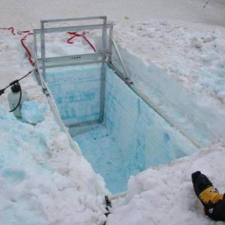
A good way to see these patterns is to apply dyed water to the land or snow surface and then dig a soil or snow pit to examine where the dye ends up. Now Williams et al. (2010) have devised a really cool device for taking sequential, thin, uniform slices of snow off the wall of a snow pit, so that they can see and measure the 3-D structure of preferential flow within the snow profile. They call their device a snow guillotine, because it is basically a sharp blade mounted on a frame that sits on top of the snow surface. A camera is also attached to the frame, at fixed distance from the blade. The blade and camera are mounted on a slider, so after taking a slice and an image of the snow and dye, the scientists can slide it a specified distance and take another slice exposing a new snow surface. (Of course, being good field scientists, all of this can be packed into a remote site, as shown below.)

Figure 4 from Williams et al (2010)

Image from Williams et al (2010) showing the snow guillotine in operation in a dyed snowpack in Colorado. Ski boot for scale.

After the scientists have taken all the slices and photos they want, they can go back to their warm, cozy offices and apply digital image processing techniques to the photos to quantify the 3-D patterns of preferential flow. The vertical images are rectified and can be stacked together into data cubes, allowing the researchers to examine the horizontal centimeter-meter scale patterns as well. You can see this in animated movie of one of their snowpacks in the supplemental materials (no paywall!).

This paper details the results of two dye experiments conducted in Colorado in May and June 2003. Both experiments occurred in isothermal (0 C) snowpacks, but in the second experiment the snow had been isothermal for a longer period of time and had ablated (melted + sublimated) more extensively than in the first dye application. The first experiment showed significant vertical and horizontal heterogeneity, particularly in the upper 20-55 cm of the snowpack, where there were up to 300 distinct vertical preferential flowpaths per square meter. At interfaces between snow layers (i.e., snow that fell at different times) there was significant lateral flow, probably as a result of permeability changes at those boundaries. In lower parts of the snowpack, downward flow was somewhat more evenly distributed and the preferential flowpaths tended to be larger. In the second experiment, more snow metamorphism had occurred, resulting in larger grain sizes and open spaces. In this snowpack, there was still some preferential flow, but, in general, flow was much more evenly distributed throughout the matrix. This finding brings into focus how the snow’s thermal history controls meltwater pathways.

All together then, the dye experiments, cut and photographed by the guillotine setup, and digitally processed in the lab emphasize the importance the small scale (cm to m) heterogeneity on flow through porous media. This isn’t super surprising to people who have spent time studying water flow through soils, but when you are dealing with snow, you add thermodynamics and a matrix that can dramatically metamorphose over time scales of hours to days to weeks to the mix. That adds a level of complexity that makes my mind boggle a little bit, yet Williams et al. have found a simple method to collect to field measurements and process the images in a way that lets them quantitatively describe these flowpaths and will hopefully contribute to a better understanding of the processes and interactions between snowpacks and snowmelt.

Williams, M., Erickson, T., & Petrzelka, J. (2010). Visualizing meltwater flow through snow at the centimetre-to-metre scale using a snow guillotine Hydrological Processes, 24` (15), 2098-2110 DOI: 10.1002/hyp.7630

Categories: by Anne, hydrology, paper reviews