New at Erratics – Biofuels: state of the science and industry

Will Dalen Rice becomes our fourth contributor to Earth Science Erratics with the first of three posts on The Advanced Biofuels Leadership Conference, held in Washington, DC in April. Will offers the newbie’s perspective on the state of the biofuels science and industry. He writes:

When looking at ways to reduce our energy dependence on foreign countries, biofuels are one solution. In an attempt to learn more about biofuels, I subscribe to and receive a daily newsletter about the biofuels industry. In early 2011, I found out about the Advanced Biofuels Leadership Conference in April. I figured I would go to this conference and learn about what biofuels were. The scope of this conference ended up being way beyond the basics, spending most of its time over my head. So, hopefully I can condense and recount what was presented, despite a much less “advanced” understanding of the products and practices of the biofuels industry.


Read the rest of his post on Erratics.

Will previously blogged at Highly Allochthonous on the topic of carbon capture and storage and urban streams with green walls.

Remember: Earth Science Erratics welcomes contributions from anyone who is tempted to dip their toes into the geoblogging waters, for one post or several, or from new bloggers who want to promote their work through cross-posting. If you’re interested, please contact us.

Categories: conferences, environment, links

Natural disasters may not always hit hardest where you’d expect

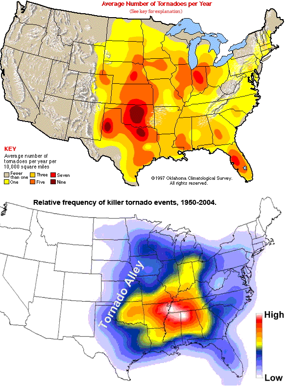
A post by Chris RowanThe week before last, the southeastern US was pummelled by a swarm of tornadoes that killed more than 300 people in 6 states, including Alabama (which appears to have borne the brunt of the damage) and Mississippi. Although tornadoes are hardly an uncommon occurrence in these states, if you were simply assessing the hazard based on the frequency of tornadoes, you might expect to be in more danger in states like Kansas and Oklahoma to the west. However, a recent study has shown that this is not the case: the most fatalities caused by tornadoes do not occur in the regions with the highest frequency of tornados, but in the states further to the east – like Alabama and Mississippi.

A comparison of the frequency of tornados in the USA (top) with the frequency of tornadoes that have caused fatalities (bottom). Note that the two peaks do not coincide.


(For another way of looking at the dataset plotted above, the New York Times has a nice interactive map/timeline of deadly tornados since 1950)

There are several reasons for this mismatch, the most important of which seem to be the higher density of mobile homes, which are much more susceptible to tornado damage, in the more easterly states; and less appreciation of tornado risks because of the lack of a focussed tornado season, and the perception of safety due to ‘Tornado Alley’ being further to the west. Sadly, the reduced risk of tornadoes occurring is more than matched by the lower resilience and preparedness of communities, which magnifies tornadoes’ impact when they do occur.

I’ve been wondering if similar factors are also an issue when considering the risk from earthquakes. Not unreasonably, a lot of attention is focussed on the seismic hazard in places which are located on plate boundaries, and where damaging earthquakes strike fairly regularly: places like California, or New Zealand, or Japan. However, while most large earthquakes do occur at the edges of plates, earthquakes large enough to do significant damage can and do occur in the interior of plates, the most famous example in the mainland US being the three magnitude 7.5-7.7 earthquakes that struck the New Madrid region between December 1811 and February 1812. In general, the risks from ‘intraplate’ earthquakes within plates are much more poorly known than the risks from ‘interplate’ earthquakes between plates: they follow less regular patterns in time and space, and because strain build up is much, much slower away from plate boundaries, there are much longer periods between one big earthquake and the next in any one area. If an active fault capable of producing large earthquakes only ruptures every few centuries or millennia rather than every few decades, they may not have left their mark in our historical records, and we may be almost completely ignorant of the danger they pose.

In the absence of this knowledge, similar factors to those that increase fatalities from tornadoes in less active areas may be important. The damage and potential casualties from even a moderate intraplate earthquake will be amplified because it will be striking an area with many, many more buildings that are not designed to withstand seismic shaking. Second, away from the regular, low level seismic activity near plate boundaries, people will not only not realise that large earthquakes are a possibility, they will we far less aware of how to respond if one does strike. Events like the recent Central US Shakeout, timed to coincide with the 200-year anniversary of the New Madrid earthquakes, are attempting to at least partially address the public awareness problem. But the fact remains that for many natural hazards, the actual risk is not purely a function of frequency and magnitude: politics, regulation and psychology are also a large influence on the potential human impact.

Categories: earthquakes, geohazards, society

Flooding along the Mississippi River

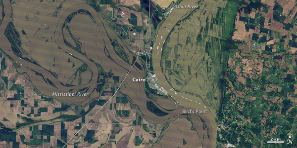
A post by Anne JeffersonIn case other events have crowded it out of your news feed, there’s record-breaking flooding going on in the Mississippi River basin. Snowmelt in the headwaters, combined with weeks of heavy rains in the middle reaches of the river basin, have pushed the system to its engineered limits. The Mississippi River basin is home to more than 100 million people, and when the water flows past Natchez, it’s carrying flow from 41% of the contiguous United States, making it the third largest river basin in the world. The volume of water carried by the Mississippi River in flood can be measured in the same unit as ocean currents — within the next few days, the Mississippi River at Natchez will be flowing more than 2 Million cubic feet per second.

Flooding at the junction of the Mississippi and Ohio Rivers, 3 May 2011, NASA image

Flooding at the junction of the Mississippi and Ohio Rivers, 3 May 2011, NASA image

Start here

For hands-down the best analysis on the flooding, the engineering, the politics, and the media coverage of the flooding, you need to turn to Steve Gough’s Riparian Rap blog. Go there now to get caught up. Then when you want some other perspective, check out the links and resources below.

General information on the flooding

Floodways doing what they were designed to do

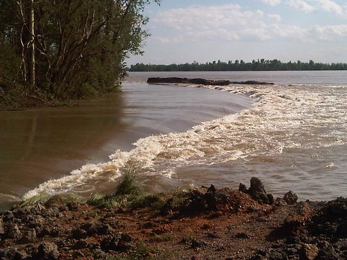
Edge of the inflow section, Bird's Point floodway. image by the US Army Corps of Engineers

Edge of the inflow section, Bird's Point floodway. image by the US Army Corps of Engineers


Early in the week the big Mississippi news story was on the opening of the Bird’s Point Floodway in Missouri. Media reports tended to focus on the sensationalist “us vs. them” people stories, with most of the stories completely missing the fact that the floodway was designed for this purposes and residents in it had known about and been compensated for its existence. Steve Gough had great coverage, including this piece.

The next big to-do will be over opening the Morganza floodway in Louisiana, expected to happen on Thursday 12 May. So far, the news media seems to be taking a bit more reasonable perspective here, but I expect there will be hysterical stories as well. My two cents: Based on experience with devastating past Mississippi River floods, our national policy has been to design and designate floodways to relieve pressure on levees on the mainstem of the Mississippi River. This means that some people miles from the main river will lose homes and property (and have been compensated for that risk), but it is for the benefit of much larger populations. Further, the areas that lie in floodways are part of the natural floodplain of the Mississippi River, and they would flood much more frequently without the levees.

More information on Bird’s Point and Morganza floodways can be found below.

Background Reading

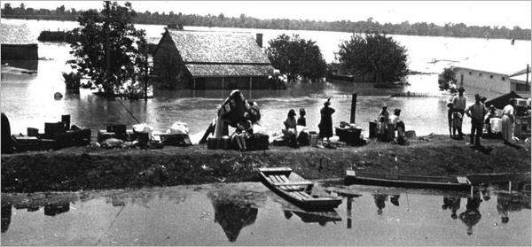
1927 Mississippi River flooding, image from the Library of Congress

1927 Mississippi River flooding, image from the Library of Congress


The best general background information on floods and flood control on the Mississippi River can be found in John M. Barry’s book “Rising Tide: The Great Mississippi River Flood of 1927 and how it Changed America” and John McPhee’s essay on the Old River Control Structure in The Control of Nature, available on-line through The New Yorker.

Categories:
by Anne, geohazards, hydrology, Uncategorized

Stuff we linked to on Twitter last week

A post by Chris RowanA post by Anne Jefferson

Things we’ve written elsewhere

  • In an invited commentary for Earth magazine (solicited in the aftermath of the arsenic life controversy), Chris discusses the impact of social media like blogs and Twitter on peer review and the discussion of published science (spoiler: they’re neither a threat nor a replacement, but could be a useful addition).
    http://www.earthmagazine.org/earth/article/43a-7db-4-1c

Water

Note: Anne will have a separate post up later today with selected links on the on-going flooding on the Mississippi River.

Environmental

Earthquakes & Tectonics

Volcanoes

Planets

(Paleo)climate

General Geology

Interesting Miscellaney

Categories: links

The many faces of earthquake triggering

A post by Chris RowanResearchBlogging.orgCan large earthquakes beget more large earthquakes? It’s an easy question to ask, but much more difficult to answer. Depending on the distance from, and time since, the initial earthquake, the processes that may result in ‘seismic triggering’ are very different – and the evidence of there actually being any effect to explain at all varies from fairly solid to rather tenuous.

The basic concept of seismic triggering is that if a particular fault is already stressed close to the point of failure, seismic energy produced by an earthquake elsewhere may, by slightly increasing the stress across the fault still further, provide the extra nudge necessary to cause a rupture. The triggering event doesn’t so much cause the earthquake as change its timing; the resultant earthquake would have happened eventually anyway, because the overall cycle of stress build-up and release on any fault is ultimately driven by regional tectonic forces that continue to operate in the background regardless.

There are two ways that a large earthquake can change the state of stress on surrounding faults: deformation of the crust around the rupture produces permanent stress changes, and seismic waves radiating away from the rupture point (which, like more standard sound waves, jostle around the material they are travelling through) produced short-lived transient or dynamic stress changes. The figure below shows how permanent and temporary stress increases on a fault, due to seismic activity elsewhere, can push it over the threshold where it will be likely to rupture. It also illustrates one of the key differences between these two modes of triggering: permanent stress changes due to deformation can not only push a fault over its rupture threshold, but keep it there, months or even years later, until the fault finally fails in an earthquake. In contrast, the stress changes due to the passage of seismic waves can only temporarily push a fault over the threshold, before the stress settles back down to its initial level. The time window in which an earthquake can be triggered by seismic waves is therefore much shorter: probably days at most.
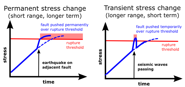
A comparison of seismic triggering due to permanent and transient stress changes. The stress across a fault gradually increases over time due to regional tectonic forces, but additional stresses from an earthquake elsewhere can push the fault over its rupture threshold earlier than expected.

These mechanisms also differ in the range over which they operate. Unlike seismic waves, which can propagate all the way around to the other side of the globe, permanent stress changes are restricted to a fairly localised area of crust around a fault rupture; deformation dissipates the forces generated by the fault’s movement before they can be transmitted large distances*. Even in the case of the very large earthquakes like March’s magnitude 9.0 Tohuku earthquake, significant static stress changes only occurred out to a couple of hundred kilometres from the rupture.
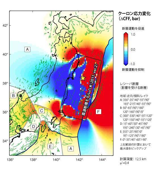
Permanent stress changes in the crust in Japan due to the March 11 Tohuku earthquake. Source: Shinji Toda, Kyoto University

Despite these differences in range and timescale, there is ample evidence that both of these mechanisms cause large earthquakes to trigger other quakes. Calculations of permanent stress changes in the wake of the magnitude 9.1 subduction megathrust earthquake that occurred off the coast of Indonesia in December 2004 indicated increases in stress on the subduction zone to the south-east: this segment then ruptured in a magnitude 8.7 earthquake in March 2005, less than a month after the stress calculations were published. A global spike in background seismic activity also tracked the passage of seismic waves from the 2004 Sumatran earthquake around the world, and the Tokohu earthquake appears to have produced the same effect. Events dynamically triggered by seismic waves from distant earthquakes tend to be small, detectable only by seismometers. A recently published study indicates that dynamically triggered earthquakes of greater than magnitude 5 – the potentially damaging ones – only occur within 1000 km** (and 20-30 hours) of the initial rupture.
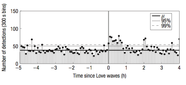
Increase in seismic activity following passage of surface waves produced by the M 9.1 2004 Sumatran earthquake. Source: Velasco et al. 2008, Fig 2.

So, earthquakes can trigger other earthquakes by inducing permanent stress changes on nearby faults: the effects are local, but the resulting triggered earthquakes can be large, and there is a long term increase in the seismic hazard on the faults affected. Earthquakes can also trigger other earthquakes due to temporary stress changes from passing seismic waves: these effects can work at great distances from the initial rupture, but are short-lived and do not appear to trigger large earthquakes at such distances. But the outstanding question is whether there is potentially a third domain of seismic triggering: a mechanism that acts at long ranges, but can trigger earthquakes sooner than they would occur otherwise, but months or years after the initial triggering event.
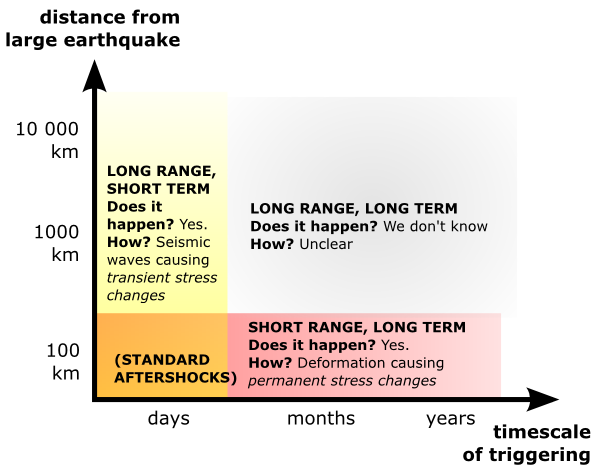
The three domains of seismic triggering. Two are proven, and understood. The third is neither, even though it probably excites the most speculation.

(Note: as Eric Fielding points out in the comments below, I neglected to mention – and show in the now amended original figure – that standard aftershocks plot in the bottom left.)

If this sounds a little bit familiar, this is exactly the sort of effect that Simon Winchester was rather recklessly speculating about a few weeks back. Unfortunately, our records of seismic activity are not long enough to tell if such a mechanism does exist, and our understanding of how faults rupture does not provide many clues as to why faults would react in such a way to a transient stress change. This doesn’t mean that they don’t, and the possibility that large earthquakes can trigger further seismic disasters at a distance clearly needs to be rigorously investigated, even if it’s only to definitively rule it out. In the meantime, however, if you’re hearing talk about seismic triggering, make sure you’re clear on which of the very different kinds of triggering is being discussed.

*Tectonic plates are often described as rigid, because they mostly move as if they are – most of the action takes place at their edges. But they’re not truly, totally rigid in the mechanical sense, as is attested by the presence of faults and earthquakes in plate interiors, and even the distribution of aftershocks following a large earthquake at a plate boundary. If you want to get technical, its probably more accurate to say that a plate is in a state of dynamic equilibrium – the driving forces on the edges and base of the plate all combine to produce coherent motion.

**Interestingly, this is the same sort of distance over which seismic waves from large earthquakes are able to trigger volcanic eruptions.

References

McCloskey, J., Nalbant, S., & Steacy, S. (2005). Indonesian earthquake: Earthquake risk from co-seismic stress Nature, 434 (7031), 291-291 DOI: 10.1038/434291a

Velasco, A., Hernandez, S., Parsons, T., & Pankow, K. (2008). Global ubiquity of dynamic earthquake triggering Nature Geoscience, 1 (6), 375-379 DOI: 10.1038/ngeo204

Parsons, T., & Velasco, A. (2011). Absence of remotely triggered large earthquakes beyond the mainshock region Nature Geoscience DOI: 10.1038/ngeo1110

Categories: earthquakes, geohazards, tectonics