 The waning days of the academic year seem like an apt time to recognize the mentors who have had an important influences on my careers. I could wax lyrical about my Ph.D. advisor, but he reads the blog and I’ll save him the embarrassment (for now). And I’ve already written about some of my memories of Reds Wolman, who was a huge influence on my and the whole field of geomorphology. Today, I’d like to introduce another key figure in my education. Even better, you’ll get to meet her in her own words.

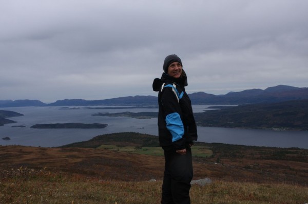
Hope Jahren near Andalsnes, Norway, one of her favorite places.
Hope Jahren is a Professor in the School of Ocean and Earth Science and Technology at the University of Hawaii at Manoa. She uses stable isotopes to understand how organisms are linked to their environment, both in modern times and in the fossil record. Her work has taken her all over the world, from the fossil forests of the High Arctic to the fast food restaurants of the American midwest. Like me, Hope is a native Minnesotan. She earned a PhD in Soil Science at Berkeley, and then held positions at Georgia Tech and Johns Hopkins (where I met her), before moving to Hawaii in 2008. Along the way she has held several Fulbrights, earned both the GSA and AGU young scientist medals and been named one of Popular Science’s “Brilliant 10.” She’s also currently the editor of GSA Bulletin, a recent Leopold fellow, and a fun voice on Twitter. I had the privilege to work with hope on my undergraduate thesis on soil water isotopes and again as an MS student, when she sent me to the fossil forests of Ellesmere Island. Recently, I emailed her to pick her brain on research, teaching, and how she got to be the fantastic scientist I know and love. Here’s our exchange:
Anne: You were the person who introduced me to the amazing world of stable isotopes, when I worked on my senior thesis with you. That thesis was on soil water isotopes in the western US. I went on use stable isotopes of water in my MS and PhD research, and now they are a core analytical technique for me. Thanks for that! So I’m wondering, what got you into isotopes?
Hope: My Ph.D. thesis explored the use of terrestrial plant carbonate — a biomineralized seed — to reconstruct paleoclimate. Some of the fundamental studies on past climate (e.g., reconstruction of the ice ages) had relied upon stable isotope measurements of marine fossil carbonates — we were hoping to do something similar with terrestrial fossils. However, as I got deeper into the project, we realized that plant physiology was exerting a great deal of control over the system … in this way, I got interested in studying how plants work, and how photosynthesis may have worked in the past.
I’ve got a new-fangled cavity ringdown spectrometer (CRDS) for analyzing water isotopes, and it is so much cheaper and easier to use than a traditional mass spectrometer. But I’m also limited to a just hydrogen and oxygen in water, unlike the versatility of a mass spec, so that’s a big downside. Do you care to say what you think the future of stable isotope spectrometry will be? Will the CRDS systems displace the old-school mass spec or am I buying into a passing fad?
I’ve never been much of a hipster instrumentalist, I’m much more interested in talking about data. I think that any method that yields quality measurements is a bonus to the field. Since I started in isotopes, many measurements that we used to do one by one “offline” are now run using automated online accessory instrumentation. This has resulted in many more data points being produced each year, but still fundamentally relies on smart people to generate and test hypotheses.
I also owe you a huge heap of thanks for sending me to Ellesmere Island for my MS research on spectacularly preserved Paleocene-Eocene fossilized forests. You went to the High Arctic for several field seasons, and I know you’ve also done field work in China. Has your science taken you to other exotic locales? Any particular favorites?
I have had the fortune to visit many places in the course of my research, including Japan, Colombia, Brazil and Ireland … as well as many places in the US. My favorite place to work is in Norway, where I spent 2010-2011. There I had the fortune to work with foresters, who are doing fascinating experiments looking at the effects of climate change on the ways in which spruce trees integrate developmental stimuli.
Your “geobiology” class also introduced me to nutrient cycles, soils, and the unforgettable concept of soil forming factors and sequences. I still have my copy of Jenny’s 1944 “Factors of Soil Formation” and I use the concept of chrono- and climo-sequences to understand the evolution of volcanic landscapes. Do you have a favorite soil somewhere in the world?
There’s an ultisol in Coweta county, south of Atlanta that is just stunning. I saw it from the car window in 1996 and have exposed it several times since then. I used to take my courses there several times a year when I was a professor at Georgia Tech.
You said on Twitter that you don’t really consider yourself a teacher, but you definitely had a lasting influence on me, both through your classroom teaching and your research mentorship. I’m sure I’m not the only student you’ve reached. What do you think makes someone a good teacher or mentor?
I don’t think of myself as a teacher in the traditional sense, because I am suspicious of the idea that research (my main interest) can be taught. What I try to do is provide an opportunity, and try to pull a student towards success. However, the student has to decide how much they push themselves in order to make something of that opportunity. I have provided a huge number of opportunities to do research over the years, to undergraduates, to grad students and to post-docs. Occasionally someone really special makes great use of the possibilities offered and succeeds, and I feel lucky to be able to facilitate that success.
When I was an undergraduate, you were early in your career. Now you’re mid-career, are spectacularly successful at research, and have been on the faculty at three universities. Now I’m an early career professor, but I’m starting to move into that mid-career phase too. Yet there’s still so much I feel like I need to learn! Any advice on successfully navigating the real and psychological transition from early career to mid-career faculty?
I think that tenure comes with new obligations, namely to push yourself harder and into riskier areas. I often want to say to newly-tenured faculty, ok, now you’ve got tenure, what are you going to use it *for*? As in, you’ve got 30-odd years of guaranteed job security and very few concrete tasks will be required of you. The concept of tenure doesn’t really exist outside of academia, and it was intended to protect academics from the standard societal pressures toward conformity. So, how will you take advantage of that protection, by putting yourself out there, and what risks will you take? The sabbatical that often follows tenure is the perfect time to reflect, switch gears, and begin taking risks.
I love seeing you pop-up on Twitter, running across your name in various journals, and having a strong female role model in my professional life. Thanks very much for your help with this interview and for being such an influential figure in my career.


Nice plan for content warnings on Mastodon and the Fediverse. Now you need a Mastodon/Fediverse button on this blog.