Storm Comin’

A post by Anne Jefferson If you live in the eastern 1/3 of the US and you haven’t started paying attention to Hurricane Sandy, today is THE day. This odd late-season storm is going to hit the northeastern and mid-Atlantic coast hard, having already stormed across the Caribbean, killing at least 48 people.
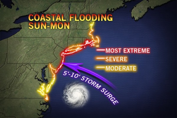
5-10 storm surge predicted by Accuweather

Accuweather map of predicted storm surges along the east coast. Click image for source. Note: I had a hard time finding both a detailed and quantitative map of predicted surges. If anyone knows of a better map, please let me know in the comments.

Much like we saw with Isaac earlier this year, the damage in slow-moving and relatively weak hurricanes (Sandy is a Category 1 currently) comes from all of the water in inland flooding and from the storm surge along the coast. When Sandy hits shore someplace between Delaware and New York City on Monday night, the storm surge is expected to be especially fearsome. As Ben Strauss at Climate Central explains:

  1. Sandy is projected to create tall storm surges, due to an enormous wind field influencing wide areas of ocean.
  2. The surge may be prolonged, due to the storm’s large size and slow movement. This means many areas will experience surge combined with at least one high tide.
  3. With a full moon near, tides are running high to begin with.
  4. Rivers swollen by significant rainfall may compound tides and surge locally.
  5. Sea level rise over the past century has raised the launch pad for storms and tides to begin with, by more than a foot across most of the Mid-Atlantic. Sinking land has driven part of this rise, but global warming, which melts glaciers and expands ocean water by heating it, appears to be the dominant factor across much of the region.

In Sandy’s path, as with Irene last year, lies the densely populated east coast. Which is why knowledgeable people are now talking about Sandy as likely to be a multi-billion dollar disaster. Jeff Masters of Weather Underground estimates that there could be as much as a billion dollars of wind damages and associated power losses, with flooding costing another billion in losses, and if the New York City transit system floods losses could run into the tens of billions.

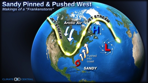
Deeply dipping jet stream, high pressure off of NE Canada and Hurricane Sandy

Credit: Remik Ziemlinski, Climate Central. Click image for source.

And all of that is just the hurricane. Added on top of that is the potential convergence of the hurricane with a very deep upper-level trough over the central U.S. and unusually strong high-latitude blocking. Blocking occurs when a high pressure dome stays in the same place for several days or longer, blocking eastern flow of the polar jet stream, producing “seemingly endless stretches” of the same weather, and pushing storms far off their usual tracks. As explained by Will Komaromi of the Rosenstiel School of Marine and Atmospheric Science at the University of Miami:

“Normally a hurricane weakens as it moves northward, as it encounters an increasingly unfavorable environment. This means greater wind shear, drier air, and lower sea surface temperatures. However, with phasing [convergence] events, the tropical system merges with the mid-latitude system in such a way that baroclinic instability (arising from sharp air temperature/density gradients) and extremely divergent air at the upper-levels more than compensates for a decreasingly favorable environment for tropical systems.”

Komaromi goes on to explain that the Atlantic Gulf Stream is unusually warm for this time of year, allowing Sandy to remain stronger than it might have while out to see. Also, the extra strong blocking over the North Atlantic will mean that the hurricane moves very slowly and the storm will track farther west over the US rather than curving out to the mid-ocean. Komaromi shows that this is extremely similar to the 1991 “Perfect Storm”, subject of the book and movie of the same name.

The fallout of all this meteorological fury is likely to be felt both at the coast and far inland. The quantitative precipitation forecast for NOAA for the next five days shows eight states with areas expected to receive more than 4 inches (101 mm) of precipitation. Far more unusual than lots of rain is the possibility that Sandy will be a “snow-i-cane” dumping up to 12 inches (304 mm) of snow in the mountains of Virginia and West Virginia, and possibly into Tennessee and North Carolina. With leaves still on the trees in southern and coastal regions, the wind, rain, and snow will play havoc with above ground power lines. Widespread power outages are considered likely all the way into western Pennsylvania, New York, and West Virginia. Even in Ohio, my area is considered in the “possible” zone for power failures.
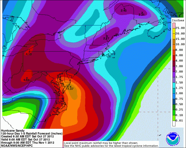
highest precip in the Delmarva Peninsula and whole map covered with ~2 inches or more

NOAA’s Hydrometeorological Prediction Service quantitative precipitation forecast for the next 5 days. Click image for more information.

In addition to watching the weather and taking the necessary steps to prepare ourselves for whatever blows our way, a small group of scientists will be collecting precipitation samples for isotopic analyses by Gabe Bowen’s group at the University of Utah. If you live in the area affected by Sandy and want to help collect precipitation, look for more information here. I’ve already gotten 1.2 inches (30 mm) of rain since yesterday afternoon, and we’re not even seeing the storm effects yet. I’m likely to get another 4 inches (100 mm) by Thursday.

A somewhat larger group of geoscientists will be working on their posters and talks while hoping to avoid power outages and travel delays that could scuttle plans to attend the Geological Society of America meeting in Charlotte, North Carolina. Charlotte is not at all in the storm’s path, so if we can get there, everything should be fine.* I’m hopeful that the freeways will be open through West Virginia by Friday night, when I’ll drive south to convene two sessions, lead a field trip, and present a poster. But I worry for colleagues in the full brunt of the storm and hope that they have both adequate time to prepare for and attend the meeting. I’m also crossing my fingers that virtually all infrastructure is functioning again by Tuesday, November 6th, and that everyone affected by the storm will be able to cast their votes in a very important election.

As I contemplate coming events, I find the song “Storm Comin'” by The Wailing Jennys has been playing in my head almost constantly. I love how it captures the tension and anticipation of a storm rolling towards you across the plains or ocean.** Unfortunately, I wouldn’t recommend following this advice for emergency preparedness, instead you should take a make an emergency kit along the lines of this one and pay attention to watches, warnings, and evacuations in your area. Be safe everyone.


The Wailing Jennys perform their song "Storm Comin'"

*Disclaimer here about being neither a meteorologist nor a disaster recovery expert, so don’t take my word as a guarantee. Also I’m glad I’m not in Italy.

**For me, music is poetry, so consider this my entry from the upcoming Accretionary Wedge carnvial on geo-poetry.

Categories: by Anne, conferences, geohazards, hydrology

On the L’Aquila trial verdict: earthquake safety is about door locks, not fire alarms

A post by Chris RowanImagine that one day, an apartment block in a major city catches fire. The fire brigade arrive too late, and the whole block burns down with people still trapped inside. An investigation reveals that the building’s fire alarm system was faulty and did not send out any warning to the residents, or the fire service. The survivors of this disaster seek legal redress against the owners of the building for failing to protect them. ‘The alarms should have sounded and warned us,’ they say. Would you agree with them? Most people probably would.

Now imagine that instead of burning down, the apartment block is burgled, and a resident who walks in on the thieves ends up being shot. Just before this, a spate of armed robberies in the local area got some press attention, and in an interview the chief of police says something along the lines of ‘we’re investigating, but crime rates are not significantly higher than usual, so please stay calm.’ An investigation in this case shows that security in the building was somewhat lacking: doors were often left unlocked. The residents again seek legal redress – against the chief of police. ‘You shouldn’t have played down the obvious danger to our building,’ they say, ‘if only you’d said we were going to be burgled, we would have made sure the doors were locked.’ Would you agree with them now?

In the L’Aquila earthquake trial, which has just concluded with the conviction of six scientists and one official for multiple counts of manslaughter, the prosecution made (and the court apparently accepted) an argument akin to the first scenario: the scientists failed to sound a proper warning (or, as the prosecution put it, they provided ‘false reassurance’ by saying there was no increased risk) before the magnitude 6.3 earthquake struck in April 2009, and they are therefore culpable for the 309 deaths that resulted. However people try to spin it into being about poor risk communication rather than a failure to predict the unpredictable, the basic underlying argument remains that there should have been a warning, but there was not, and therefore people died.

However, as I argued back when the trial first kicked off, there was no scientifically justifiable reason to think there was an elevated risk of a large earthquake, beyond the background risk of living in a seismically active region with a history of large earthquakes. The regional swarm of smaller earthquakes that prompted the fateful meeting between the scientists and the Italian Civil Protection Agency said nothing about the chances of an earthquake within the next week, within the next month, or the next 5 years – except in hindsight.

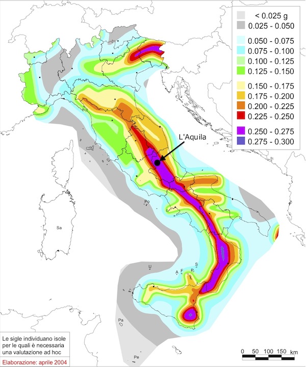
Seismic hazard map of Italy

Seismic hazard map for Italy, showing the peak ground accelerations that have a 10% chance of being exceeded in 50 years. There is always a high earthquake risk near L’Aquila. Source: INGV.

In fact, I’d argue that this situation was a lot more like the second scenario I described above; that earthquake hazard is much more akin to crime rates than fire risk. Crime is a fact of life in a big city, and if you’re sensible you don’t wait for specific warnings to take precautions. Every day, regardless of any specific crime wave going on at the time, you lock your doors; you secure your valuables; you take care where you walk at night. These everyday, habitual actions minimise the risk, but everyone is aware that despite these precautions, you might still get burgled. The police chief’s comments were not intended to imply there was no risk of crime at all, and in an ideal world should probably have ended with an admonition to take the normal precautions of locking your doors. However, if the residents of the burgled flats were unaware that cities have higher crime rates, and certain actions make you safer, and suffered as a result of this lack of knowledge, I’m not sure you can assign blame to one man speaking in one interview: it points to a much deeper communication issue.

In a similar fashion, there is never a time when the people of L’Aquila are not at risk of a large earthquake – it’s a fact of where they live, irrespective of what background seismic activity is occurring at any particular time. The downfall of the prosecuted scientists appears to be that they made their assessment of no elevated risk in this context, not realising that most people (including, perhaps, Bernardo De Bernardinis, the convicted Civil Protection Agency official) did not understand that “no elevated risk” did not mean “no risk”. This points to a communication failure, but a long-lived, systemic one, not specific to these scientists and one press conference.

In earthquakes, lives are almost never saved by evacuations before the fact, because specific, timely warnings are currently scientifically impossible. They are saved by rigorous and well-enforced building codes, and a populace that knows to drop, cover and hold on. This is why the L’Aquila verdict is so damaging: not only will it have a chilling effect on what scientists are willing to say in public about the geological risks an area or population face, but it reinforces the all-too-common idea that earthquake safety is like a fire alarm; you only need to take action when there is a specific short-term warning. It’s like expecting the police to show up at your door to warn you that your house is probably going to be robbed tomorrow – and only then locking your doors. We need to get people focussed on the door locks – basic, everyday actions that improve their safety – instead.

Categories: earthquakes, geohazards, public science, society

Stuff we linked to on Twitter last week

A post by Chris RowanA post by Anne JeffersonWe interrupt our regularly scheduled link-fest for a brief celebration of how much the geoblogosphere – and our readers – rock.

At the end of Earth Science week, we can only look in awe at the generosity and commitment of our colleagues and readers to funding earth science education through DonorsChoose. As a glance to our sidebar shows, donations to our own giving page have exceeded $800, and have already helped to fund 6 projects, giving students in cash-strapped schools the chance to build quake-proof models, measure water quality, and much more.

In addition to our own challenge, the Ocean & Geobloggers collective also includes:

Collectively we’ve raised almost $3000 since Monday. We basically rule the Science Bloggers for Students leaderboard right now, demonstrating – as if it needed proving – how much more awesome we are than any other science. To those who have already donated – thank you so much.

We now return to our regularly scheduled highlighting of things worth reading on the internet this week.

Other posts on All-geo

Earthquakes

Volcanoes

Fossils

Planets

(Paleo)climate

Water

Environment

General Geology

Interesting Miscellaney

Categories: links

Scenic Saturday: a good place to map

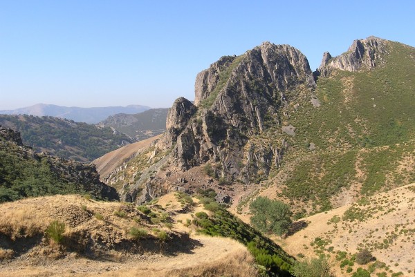
A post by Chris RowanAs part of Earth Science Week, yesterday was geologic map day – a celebration of the importance of maps in geology. This had me waxing nostalgic about the weeks I spent teaching mapping in the Cantabrians of northwest Spain, before I set off on my multi-continental postdoc odyssey. It was a beautiful area:

Cantabrians south of Villamanin, NW Spain. Photo: Chris Rowan, 2005.

What made it such a good place to teach mapping? There was good exposure – there were very few places where there was no outcrop at all. There were a number of distinct rock types – limestones, sandstones, and shales of Paleozoic age – that were relatively easy to distinguish from field observation. And the distribution of these rock types was interesting: if you look at the ridge of limestone in the picture above, you can see that the beds have been tilted from their original horizontal orientation to an almost vertical one – a result of this area being caught up in the in the Variscan orogeny. As well as the regional structure there was lots of interesting stuff at the hillside scale to encourage copious use of the compass clinometer.

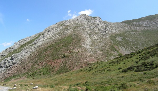
Plunging antiform in the hillside, Cantabrians south of Villamanin, NW Spain. Photo: Chris Rowan, 2006.

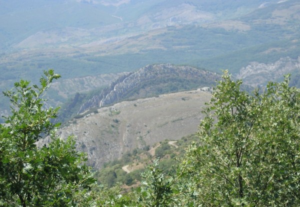
The whole region was also a beautiful example of the landscape being controlled by lithology, with high ridges of hard limestone and quartzite separated by valleys of more easily erodible shales. One distinctive unit had two narrowly separated limestone beds with shale units above, below and between, forming what we colloquially referred to as ‘stegosaurus ridges.’

‘Stegosaurus Ridge’ of vertical limestone beds in shale, Cantabrians south of Villamanin, NW Spain. Photo: Chris Rowan, 2006.

So, plenty to stimulate the mind of budding geologists. Feel free to reminisce about your favourite mapping areas and what made them special in the comments. And, while you’re at it, consider giving a few dollars to help support teaching the next generation of mappers.

Categories: fieldwork, geology, photos

Where tsunamis and nuclear power could meet

A post by Chris RowanOut of all the devastation wrought by the Tohuku earthquake and tsunami in March 2011, the escalating disaster at the Fukushima nuclear plant has ended up having the biggest global impact. A catastrophic loss of cooling led to meltdowns, explosions and a release of radioactive material into the atmosphere – and seems to have slammed the brakes on a nuclear industry that had been pretty bullish about its role in weaning us off of our fossil fuel addiction, as safety concerns have once more come to the fore.

Japan, which prior to Fukushima generated almost a third of its electricity at nuclear power stations, is reconsidering its generation mix: the government recently announced that it plans to shut down all 50 of its presently operating reactors (many of which have already been shut down in the months following Fukushima for safety checks), although this commitment seems to be somewhat at odds with a commitment to go ahead with constructing new, already-approved nuclear plants. In the wake of an incident which elevates safety concerns above the perceived benefits of greater energy independence and lower carbon emissions that nuclear power promises, it’s easy to grasp the reasoning behind this; especially in the light of the parliamentary investigation that uncovered a disturbing degree of collusion between the TEPCO power company and the Japanese government to water down or circumvent earthquake safety measures.

It has been more puzzling to see the responses from Germany, who last summer decided to phase out all of it’s nuclear power plants by 2022, and France, who this summer elected a new government that has promised to slash the proportion of nuclear in their generation mix by a third, from 75% to 50%. Although some public concern is unsurprising, the fact remains that a Fukushima-type incident requires a nuclear plant built on the coast near a subduction zone capable of generating a major earthquake and subsequent tsunami. Unlike Japan, Germany and France are not high up on my list of possible places where these criteria are met. However, it is also unlikely that Japan is the only place on earth which faces these risks – a possibility that is the subject of a recent short paper in the Journal Natural Hazards, which adds up all the nuclear plants built or in the process of being built in coastal areas that could get in the way of a tsunami generated by a great subduction zone earthquake. Although the vast length of coastline at risk from large tsunamis includes much of the Pacific Rim, it is only in South-East Asia that these danger areas host nuclear power plants. The Natural Hazards study identifies 17 separate sites hosting a total of 49 reactors that are potentially at risk, distributed between Japan, China, South Korea, Taiwan, India and Pakistan. Four of these sites are in the process of being expanded, adding 9 reactors to the total; and a further 16 reactors are being built at 7 entirely new at-risk sites, 5 of which are in China.

It is unclear – and this paper does not address – what, if any, impact the Fukushima disaster has had on the safety measures in place at the at-risk nuclear plants outside of Japan, and the worst-case scenarios being designed into the plants under construction. It seems unlikely that the seismic risks have been completely ignored, but one of the lessons of the Tohuku earthquake is that our understanding of the long-term tsunami hazard is still extremely tenuous, and our assumed worst-case scenarios may be nowhere near the actual worst.

On the flip side, it is easy to be critical of decisions to locate a nuclear plant in areas with high tsunami hazard, but that ignores the fact that many other factors, such as population distribution,access to cooling water, and the viability of other generation sources, are also important constraints. Nonetheless, it seems clear that the nuclear backlash from Fukushima has perhaps not been focussed where the geological facts suggest it should be.

Discussions like this emphasise how important it is to teach think properly about geological hazards: our DonorsChoose Giving Page includes several projects that get students thinking about how earthquakes work. Please think about donating a few dollars to the cause!

Categories: geohazards, society