Earthquake hazard mitigation the Iranian way

A post by Chris RowanThe Guardian reports that the Iranian government has approved plans for a new capital city. It seems this decision was at least partially driven by fears that the present capital, Tehran, is facing some serious earthquake hazard in the future:

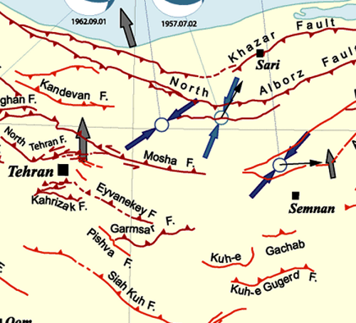
Plans for a new capital were first drawn up 20 years ago, but officials only gave them serious consideration after the 2003 earthquake that devastated the south-eastern city of Bam and killed an estimated 40,000 people. Experts warn that Tehran sits on at least 100 faultlines – including one nearly 60 miles long – and that many of its buildings would not survive a major quake.

Iran is part of the Alpine-Himalyan Belt, formed as the African, Arabian and Indo-Australian plates all push northwards into Eurasia. In Iran, seismicity is concentrated in the Zagros mountains in the south and the Alborz mountains in the North, with both of these mountain belts apparently being actively uplifted as they accommodate plate convergence.

iran_sesimicity.png

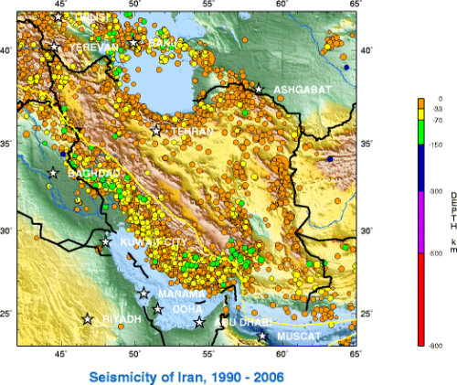
Tehran, with a population of about 12 million people, is located just on the southern edge of the Alborz mountains, and a map of the major faults in the area shows that it is surrounded on all sides by sizeable thrust faults.

Tehran_Faults.png

So, at first glance a relocation seems like a fairly foresighted strategy, even if a cynic (who, me?) might wonder if the move encompasses more than the political elite and their associated minions. But population centres do not generally spring up at random; there are usually strategic and/or economic reasons that people have settled in a particular location, and once established they tend to suck in ever more people and investment as time goes on. Add to that our general inertia in the face of abstract future risk (just look at the response to climate change) and you have to wonder if people will be all that willing to move. There’s also the question of how the cost of abandoning all the infrastructure incorporated into a large city like Tehran, and building a whole new infrastructure in your new city, compares to the cost of increasing peoples’ safety by enforcing robust building codes: after all, earthquakes don’t kill people, collapsing buildings do*.
In the long term, of course, it makes sense to move as much of your population as possible from areas of high seismic risk to low risk areas, by encouraging investment in geologically safer areas and letting economic migration rebalance the population over a generation or three. Sadly, I suspect urban planning is generally driven by somewhat narrower, short-term factors; if building houses on flood plains is waved through without blinking, I can’t see nearby faults giving people much pause.
*and tsunamis. But not in Tehran.

Categories: earthquakes, geohazards, tectonics

Advice and Advocacy

A post by Chris RowanGetting involved in science policy is a tricky business. For the most part, a statement made by a scientific expert is taken as more authoritative than a statement by a government minister, even when the expert strays away from talking about data and evidence and probabilities – the input into a policy decision – and starts talking about translating those data into action – the decision itself. I don’t think scientists shouldn’t suggest courses of action, but they shouldn’t do it in a unilateral way. It’s the difference between ‘studies show x, and y appears to be a promising approach to dealing with this’ (ok) and ‘studies show x, so we must do y’ (not so ok). A fine distinction, perhaps, but one worth trying to make as hard as possible.
Of course, in the case of David Nutt’s forced resignation from the Advisory Council on the Misuse of Drugs (ACMD – see also here and here), it appears to be more a case of ‘studies show x, it would be sensible to do y, but government has not only done z, which is silly/unworkable, but claims its policy is evidence-based.’ Untangle that, if you dare.
It’s obvious that scientific evidence is just one of the things that ministers take into account when making policy decisions. When it comes to drug regulation, for example, beyond issues of harm there are questions of social impact on particularly at-risk groups, and (when it comes to alcohol and tobacco) long-standing societal mores, which also have to be considered when formulating policy, and perhaps might justify going against the recommendations of a body like the ACMD. As a scientist, I have no problem with that – as long as the decision to go against such advice is justified in those terms. Where it does become a problem is when, for whatever reason, a recommendation based on the best available science is ignored, yet the government continues to assert that it is following an ‘evidence-based’ policy, rather than acknowledging that its decisions are clearly being driven by other concerns.
It is this lack of transparency that worries me; and a scientist who actually faces the paradox of being consulted by the government to provide a veneer of scientific authority, whilst having their actual opinion on the issue at hand ignored, is perhaps justified in getting a little annoyed .
I once described Tony Blair’s attitude to science thusly:

…he does not seem to want a electorate that is truly scientifically literate, but one that will accept scientific authorities as expert witnesses in support of government policy.

It seems that this attitude is still prevalent amongst politicians here in the UK; and if David Nutt did sail over (or very close to) the line between advice and outright advocacy, I think it’s at least partly because we have a government which refuses to discuss complex and controversial issues in a grown-up manner.

Categories: public science

To our amazing readers, we are humbled. Post requests are now open.

A post by Anne JeffersonGeoblog readers are truly amazing. Between you, you gave $8660, making earth science a hands-on reality for 1270 students. Forty-three of you, with a little help from HP, gave more than readers of any other ScienceBlog. Thank you. Your generosity humbles me.
A few weeks ago, during Earth Science Week, I offered up posts by Chris and I on topics of our readers’ choice. Then Kim willingly jumped in to help. We promised to write one post for each project completely funded during the week with help from geoblogs readers. By the end of the week, you all had funded five amazing projects:

Check out the links above to see thank you notes from the teachers and photos of the projects in action. Seeing the students excitedly looking at rocks is the biggest reward I can imagine. But, if you want us to reward you by producing posts on topics that get you excited, here’s your chance to nominate the topic.

In the comment thread below, make your requests, and Chris, Kim, and I will look through them and select five topics that we feel most able to answer. Then we’ll get to work fulfilling them as we can manage in our busy schedules. Maybe we’ll get inspired and pick up even more of your ideas for future posts.

Categories: bloggery, science education

ScienceOnline 2010: geobloggers required

A post by Chris RowanRegistration is now open for ScienceOnline2010, the fourth annual science communicators conference, being held January 14-17 next year in the Research Triangle Park area of North Carolina.

Please join us for this free (but donations are accepted) three-day event to explore science on the Web. Our goal is to bring together scientists, physicians, patients, educators, students, publishers, editors, bloggers, journalists, writers, web developers, programmers and others to discuss, demonstrate and debate online strategies and tools for doing science, publishing science, teaching science, and promoting the public understanding of science.

I’ll be there, but that’s probably a rather dubious temptation; however, if you check out the numerous interesting discussion topics enshrined in the semi-finalised programme you’ll see that there is a session entitled ‘Earth Science, Web 2.0+, and Geospatial Applications’, being run by Jacqueline Floyd with back-up from yours truly. That’s right, a specialised session which doesn’t involve biology.
Hopefully this might tempt some of the rest of the geoblog/tweetosphere to attend as well. Even if you can’t attend, Jacqueline and I are keen to get as much participation from all of you as possible. Feel free to get in touch with any ideas you might have, but in a perfect world we’d have you all there participating – and if you’re physically there, I can buy you a beer. Places are vanishing fast, so don’t ponder too much: Register today!

Categories: bloggery, public science

Hydrogeology and geomorphology: Notes from GSA Monday and Tuesday

A post by Anne JeffersonLast week was the Geological Society of America meeting in Portland, Oregon. Just below t is a view of Mt. Hood looking from the north, which I might have seen if I were not busy in and around the convention center the entire time. What follows are some brief notes from my activities on Monday and Tuesday of the conference. Mt Hood from the North
Monday
On Monday morning, I attended a couple of talks and browsed the deserted poster aisles, since I knew I would be in a session all afternoon and unable to attend the designated poster time. Of the talks I attended, the one that sticks most in my mind was one by Karen Gran, who opened with an eloquent argument for why geomorphologists should care about the landscape evolution of very flat places, in her case, the Le Sueur River in southern Minnesota. Here the sudden base level drop triggered by the draining of Lake Agassiz down the Minnesota-Mississippi River system has triggered 11,000 years of knickpoint retreat and bank erosion that has been exacerbated by modern agricultural practices, such as tile drainage.
Monday afternoon I helped convene a session on “Stream-Groundwater Interaction: New Understanding, Innovations, and Applications at Bedform, Reach, and River Network Scales” sponsored by the Hydrogeology division. We had a great line-up of speakers, from undergraduate to professor, that are actively pushing our understanding of how streams and groundwater interact in environments from the hydropower-generating diurnally-fluctuating Colorado River in Austin, Texas (Bayani Cardenas, Katelyn Gerecht) to the possibility of modern recharge to the Great Artesian Basin in the center of Australia (Brad Wolaver working on the Finke River). We heard about a new smart tracer for quantifying the metabolically active transient storage (Roy Haggerty), radium as a tracer of groundwater inputs to the Sea of Galillee and North Carolina’s Neuse River (Hadas Ranan), electrical resistivity for mapping saline upwelling in Nebraska wetlands (Ed Harvey), and lots about using temperature as a tracer of groundwater-stream interactions (John Selker, Christine Hatch, Laura Lautz, Jeannie Barlow). We contemplate the effects of our common simplifying steady-state assumptions (Jesus Gomez) and marveled over a flume and numerical investigation of hyporheic exchange caused by a simple log (Audrey Sawyer). The questions from the audience were provocative and the conversations during our breaks were enjoyable and stimulating. It was my first time chairing a session, and I couldn’t have been more pleased with the day it turned out.
Monday evening brought the usual round of alumni receptions and the geoblogger/tweeter meet-up. Much has been said about that elsewhere, but I’ll add that I greatly enjoyed making the acquaintance of so many interesting people and renewing my friendship with others. There were definitely a couple of small-world moments over the course of the evening, and I’ll hazard that it was the largest geoblogger/tweeter meetup on record. Shall we aim to break the record next year?
Tuesday
On Tuesday, I did not go to a single talk. There are no geomorphology sessions on Tuesday because of the Kirk Bryan field trip, and the hydrogeologists have no oral sessions because of their afternoon banquet. So I spent the morning over a wonderful breakfast with wonderful friends and attended the hydrogeology banquet almost immediately thereafter. In the late afternoon, I presented my poster and missed Kim’s talk and then meandered my way over to the Quaternary Geology and Geomorphology (QG&G) award ceremony and mixer.
Please don’t ask me to say who knows how to have more fun: the hydrogeologists or geomorphologists. All I’ll say is that singing was involved at one event and very clever photoshopping at another. At least one set of geologists believe it is perfect acceptable to receive a major professional award while wearing jeans and holding a beer.
For me, the single best highlight of the entire week was talking to Reds Wolman, my academic grandfather and undergraduate geomorphology professor. Reds is an amazing teacher, magnificent scientific mind, and a caring person who mentored many of the leading geomorphologists of the last half century. Though he’s gotten to be quite elderly, he attended much of the meeting and I got the chance to chat with him and hear his stories several times. I’ll also got to hear a very nice, if cheeky, tribute to him by Reds’ former student, John Costa, who was awarded the QG&G distinguished career award.
In my next post, I’ll finish out the meeting by talking about what happens when it rains a lot about this time of year and the mountains fall down. Plus, I’ll show some pictures of really big rocks.

Categories: by Anne, conferences, geomorphology, hydrology