Haiti: what next for the Enriquillo Fault?

A post by Chris Rowan I’ve been invited to contribute to Haiti Rewired, Wired’s collaborative conversation about rebuilding post-earthquake Haiti. Obviously, geology – in particular, future seismic hazard – is an important consideration when making decisions about rebuilding Haiti, and ensuring that the inevitable future earthquakes are better prepared for. Anything I post there will get cross-posted (with a delay) here, but I encourage you all to go and have a look at Haiti Rewired, and see whether you can make any contributions to the discussion yourself.

The earthquake that rocked Haiti two months ago was produced by the rupture of a roughly 50 kilometre section of the Enriquillo Fault that runs through southern Haiti. The total length of this fault system, which accommodates about half of the westward motion of the North American plate relative to the Carribean plate that occurs in this region, is several hundred kilometres. This means that on the sections of the fault adjacent to January’s rupture, the strain built up by several hundred years’ of plate motions is still there, waiting to be released. The only question is when, and how.

In fact, the recent seismic activity may have actually increased the risk of one of these neighbouring segments failing in another large earthquake. When a fault ruptures, the sudden motion stresses the surrounding crust. The aftershocks that followed the January 12th earthquake were one result of this. But the ‘surrounding crust’ includes the adjacent, unruptured segements of the Enriquillo Fault, and placing more stress on them can potentially bring these sections closer to the point where they too will fail. Modelling of the deformation resulting from January’s rupture (shown in green on the figure below) indicates that the largest stress increase (red) has been on the 50 km section immediately to the east, with a significant but smaller increase on a 20 km section just to the west.

Haiti_rupture2.png

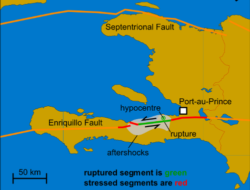
The increased stress on these parts of the fault potentially mean that they will rupture sooner rather than later. This is of particular concern for the eastern fault section, which runs only a few kilometres to the south of Port-au-Prince. This is so close that even a moderately large earthquake could do a lot of damage (the actual shaking intensity due to an earthquake is strongly dependent on the distance from the rupture point, as well as the total energy released).

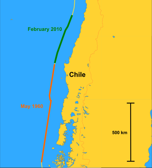
Of course, in geological terms, ‘soon’ does not necessarily mean next month, or even next year. To take a topical example, in May 1960 the largest earthquake ever recorded, with a magnitude of 9.5, was the result of a rupture almost 1000 km long on the subduction thrust off the west coast of Chile. This placed more stress on the fault segment immediately to the north, which eventually ruptured. Fifty years later.

Chileruptures.png

In contrast, stresses induced by the magnitude 9.1 earthquake that occurred off the coast of Indonesia in December 2004 probably contributed to the rupture of a neighbouring section of the Sunda Trench in a magnitude 8.7 earthquake a mere 4 months later. The problem is that the effect of these additional stresses depends on how close a particular part of the fault is to failing already. If it is already quite close to the point of failure, adding a bar or two of additional stress may push it right to the brink of rupturing or beyond; if not, then the additional loading will not have such an immediate effect. How do you tell the difference? Not very easily, although hopefully collecting data on current and recent deformation around the Enriquillo Fault, through close study of comparative radar imagery (several examples are available here) and new GPS data might provide some clues. More detailed study of the historical activity of the Enriquillo Fault – how large past ruptures were, and how activity on adjacent sections was correlated – might also provide some insight into the possible seismic future.

Categories: earthquakes, geohazards, tectonics

Highlights of the Geological Society of America NE/SE Section Meeting

A post by Anne JeffersonI’ve just returned to Charlotte after spending a few days in Baltimore, Maryland attending the combined Northeastern and Southeastern Section Meetings of the Geological Society of America. It was a really good conference, with lots of cool science, good people, and a fun setting.
I tried to tweet some highlights of the conference as I went, but for those of you not following me (@highlyanne) on Twitter, I’ve attempted to reassemble the conference based on my 140 character soundbites. Note that the unofficial conference hashtag (a way of following topics on Twitter) was #geoBAL, so I incorporated that into most of my messages. There wasn’t a lot of users of the hashtag, but I did get sneak peeks into some of the other sessions. Below the fold, you can get a sneak peek into my conference experiences, both scientific and touristy.

Continue reading

Categories: by Anne, conferences

Lecture notes

A post by Chris Rowan Some wag in the comments to my last post not-so-subtly noted the slight lack of blogging activity from yours truly in the last few weeks. There are actually three inter-related reasons for this impromptu break. Firstly, I’ve been lecturing three times a week for most of the last month, so quite a few of my evenings have been spent preparing for them. Secondly, I had to fight off a bout of stomach flu, which meant that the times when I wasn’t preparing for lectures I didn’t really feel like doing anything. Thirdly, my days at work have been spent in the lab trying to get our new magnetometer working properly. All this has meant that my blogging muse has had to get used to being crowded out.
Lecturing has, as usual, left me feeling rather ambivalent. Standing up in front of an entire class is where I suffer the most from imposter syndrome. I’ve never received any formal education training, after all, and the lecture theatre is when I feel that lack the most. When demonstrating in labs and on field trips, and supervising students on projects, there is at least the prospect of being able to assess your own effectiveness, by talking with the students, and checking their work, and asking them questions. Through these constant interactions, I’ve managed (hopefully) to become a better teacher – I can see which approaches work, which don’t, and, more importantly, identify problems in understanding as they come up and deal with them accordingly. Standing up at the front of a lecture theatre, it’s much more difficult: you do most of the talking, they do most of the listening. Even if you encourage the students to ask questions, it’s not exactly common, so you find yourself wondering whether they’re not asking questions because they’ve understood what you’ve been talking about, or because they don’t want to admit that you lost them within the first five minutes. Of course, given how tentative most post-grads/docs are in asking questions during and after talks, you can hardly blame first years for being a little cautious about speaking up.
So although I’ve done a fair amount of lecturing now, it worries me that I really can’t say with any confidence if I’m actually any good at it or not. I think I’ve gotten much better at pacing myself, and not trying to cram too much information into too short a time – lectures are sort of like anti-conference talks, which is a bit of a problem when that’s your only real experience when you first start lecturing. I’ve also begun to appreciate that a pen and whiteboard can be much more effective than a powerpoint slide and laser pointer, especially when you’re talking about basic concepts. But still, I fret. Perhaps my readers have some suggestions for how you can objectively assess your effectiveness in the lecture theatre beyond the quality of answers in the exam. Just remember – I’m not a member of the teaching staff; I was covering part of a course for a member of staff who was on sabbatical. So it’s hardly my place to completely retool the teaching model.

Categories: academic life, ranting, science education

Earth’s forgotten youth – and beyond

A post by Chris RowanResearchBlogging.orgThe further back in time we go, the more and more fragmented the Earth’s geological record becomes. Whilst not exactly common, rocks with ages up to about 3.5 billion years old are found at multiple points on the Earth’s surface. However, rocks older than this are much less common. Extensive outcrops older than about 3.8 billion years are exceptionally rare, possibly because a series of very large meteorite impacts prior to this time – the Late Heavy Bombardment – largely destroyed any older bits of crust. The Acasta Gneiss in northern Canada, dated at around 4.03 billion (4030 million) years, is generally regarded as the oldest known outcrop of crust, although a recent study has claimed that the Nuvvuagittuq greenstone belt, also in northern Canada, may be as old as 4280 million years. The only known bits of the Earth that are older are 4.2-4.4 billion year-old zircon crystals found in the Jack Hills Conglomerate in Australia; the conglomerate itself was deposited about 3 billion years ago, but it contains debris eroded from much older, and now long-vanished, bits of crust.
Two or three data points is not a hell of a lot to go on when trying to reconstruct the evolution of the early Earth, especially when the material involved is far from pristine (the Acasta Gneiss, being a gneiss. has been partially remelted, for example). It is therefore no surprise that the geological timescale for the period between the Earth’s formation, about 4.56 billion years ago, and the start of the Archean Eon, usually pegged at about 3.8 billion years ago, is rather lacking in detail. This period is usually referred to as the ‘Hadean’, which is more of a reference to the presumed conditions on the Earth’s surface than a subtle pointer to the fact that we don’t know what the hell was really going on.
However, this has not stopped Colin Goldblatt and his co-authors having a go at adding a bit more structure to the Earth’s earliest days – and beyond. The ‘Chaotian’ eon at the start of their proposed new timescale is a common framework for the entire solar system, beginning with the gravitational collapse of the gas cloud that it would eventually form from. Key events – such as the initiation of solar fusion, or the first interactions between sizeable protoplanets that condensed from the protoplanetary disk – mark the boundaries between different eras and periods within the Chaotian. The start of the Hadean is marked by the collision of the proto-Earth, which the authors call Tellus, with another Mars-sized protoplanet, forming the Earth-Moon system.

Hadean.png
Proposed new timescale for the formation of the solar system (Chaotian) and the evolution of the early Earth (Hadean). Click for a larger image

Thus, the Chaotian marks the time when solar system first became a distinct entity from the galactic neighbourhood; the beginning of the Hadean is when the Earth’s geological history begins to be shaped as much by internal processes, such as mantle convection, as by external events such as collisions with other protoplanets, Similarly, from beginning of the Archean, at the end of the Late Heavy Bombardment, internal processes start to completely dominate the Earth’s geological evolution; extraterrestrial collisions can still have significant geochemical and biological impacts, but they no longer melt the entire crust. Conceptually, I find this quite a nice way of looking at it.
The authors also attempt to subdivide the Hadean, but because we still don’t understand the key events in the Earth’s geological development over this period, it’s not quite as successful. The Hephaestean period probably covers the recovery from the Moon-forming impact. The Jacobian, Canadian and Acastan periods refer to the Jack Hills zircons, Nuvvuagittuq greenstone belt and Acasta Gneiss, respectively, but although these outcrops can give us clues about what the Earth was like when they first formed, it is a bit risky to try to characterise an entire planetary system from one sampling point. For example, the Jack Hills zircons tell us that granite – in other words, continental crust – was forming 4.4 billion years ago, but this is only a minimum age; we have no evidence that it wasn’t forming before that. Also, for all we know greenstone belts were also forming at exactly the same time, and have just not been preserved. The small amount of data we have available means that a single new outcrop might force the entire timescale to be redrafted.
It’s difficult to know if we’re ever going to be able to construct a truly robust, process based timescale for the first 700 million years of Earth’s history, because it’s unclear how much we’ll ever truly know about the Hadean. Still, this is an interesting attempt to set the story of our planet’s birth into a slightly more structured framework.
Goldblatt, C., Zahnle, K. J., Sleep, N. H., & Nisbet, E. G (2010). The Eons of Chaos and Hades Solid Earth, 1, 1-3

Categories: deep time, geology, paper reviews, past worlds

Carbon capture and storage: where should it go?

Will Dalen Rice and a friendNote: This is a guest blog post from Will Dalen Rice, a graduate student in the Department of Geography and Earth Sciences at UNC Charlotte. He has the misfortune of taking a couple of courses from Anne this semester, and he’ll be contributing a few more blog posts here over the next few months.
Carbon capture and storage gets media attention along with global warming, but few media outlets have attempted to describe what it actually is. The importance of this technology lies in the truth that the largest chunk of our greenhouse emission are a result of creating power. One-third (1/3) of emissions in the world come from power plants producing 10 billion metric tons of CO2. So, the logical step in reducing CO2 levels (putting aside the obvious of “needing” less power) is to intercept them as they leave the power plant, preventing them from going up into the clouds. Once you have a cup full of liquid CO2 though, where do you put it? Hint: Where have we always put things we didn’t want to have around anymore?
As it turns out, the process of natural gas extraction already requires CO2 to be separated and dealt with. A Norwegian oil company has been running an experiment to figure out if we can indeed “bury” this CO2. The more technical term is injection, and it involves putting the carbon inside of an aquifer. Aquifers are geologic sandwiches that are usually of interest since they hold water or gas, which we want to remove. The test aquifer (a sandstone) is located in the North Sea, and has been receiving injected CO2 since 1996. In addition to serving as a viable source for the waste CO2 removed from the natural gas, it also is giving us information about what happens when you put this kind of carbon into the ground and it allows further extraction of gas, as long as you keep “refilling” the aquifer and keeping the sandwich intact (like swapping the meat with, well, carbon).
The only requirements are that the aquifer be very porous and permeable (can you pour water though it like water through sand?) and that the confining units be very thick and impermeable (can you pour water through asphalt?). The test site for this oil company is in deep marine deposits (bottom of the North Sea). On the other side of the spectrum, most efforts in the US have focused on saltwater aquifers located on land. Both types of sites will need to be used to accommodate all the carbon we make.
For now though, the deep geological marine injection seems to be the better option. This is for two reasons. First, at extreme depths and pressures, the CO2 becomes denser than saltwater. This means that any leaked carbon will stay at the bottom of the ocean, as the ocean water “floats” on top of it. The second bonus is that the capping material (“bread”) for deep marine aquifers is unconsolidated clay, which means it cannot form a crack and hold it, giving an easy escape path for CO2.
Deep marine environments offer other advantages as well. Keeping the CO2 in liquid form requires pressure regulation, a more difficult process in land-based aquifers. Proposed land-based aquifers also have chemically complex and toxic saline (salty) solutions that would need to be removed to make room for the CO2. Drilling extra wells to release fluid and pressure in deep marine aquifers just lets out salt water into the ocean, not a problem at all. Lastly, marine land is not disputed, whereas ownership of space at depth on regular land is a more sticky issue. For these reasons, the deep marine CCS systems are likely going to be the first attempt at lowering our CO2 levels in the air.
For more information, you could start here: Schrag, D. 2009. Storage of Carbon Dioxide in Offshore Sediments. Science. 325 (5948): 1658-1659. doi: 10.1126/science.1175750

Categories: climate science, hydrology