Legendary fluvial geomorphologist Reds Wolman once said “Floods come from too much water,” and that’s the phenomenon distilled to its core essence. But this bit of wisdom doesn’t give us much to go on if we want to understand what creates floods or why some areas are more flood-prone than others. It’s the cooking equivalent to “Bread comes from flour.” How do we turn the flour into bread? How do we turn too much water into a flood?
In this blog post, I’ll create a cookbook for riverine floods, explaining the different phenomenon that generate floods and linking to examples that I or others have written about. I’ll be drawing heavily from the framework of a 2002 book chapter by O’Connor, Grant, and Costa called “The Geology and Geography of Floods” and as such I won’t be focused on the particulars of flood hydraulics or routing as the meteorologic, hydrologic, and geologic factors that are preconditions for floods. In a sense then, I guess I’m writing ingredients lists, not the full cookbook.
The first and most obvious ingredient you need for a flood is water. A lot of water. But if you have a lot of water draining slowly over time, that’s not a flood. It’s a river. So we need to have a lot of water, stored somewhere, and then release it quickly. Since the ways water can be released quickly are closely tied to where the water is stored, let’s start with storage.
Water can be stored as vapor in the atmosphere, liquid at the earth surface (in some sort of reservoir), or solid at the earth surface (i.e., ice or snow). That gives us a universe of three main types of floods: meteorological floods, dam break floods, and snow or ice melt floods. But those types are not absolute and bounded. You can have cross-overs. It can rain so hard as to burst a dam or rain on top of snow, melting the snow. But some floods are caused simply by too much rain, and these meteorological floods are the most common. That’s what I’ll cover in this blog post. (Look for volume 2 of the cookbook to cover how terrestrial water storage can lead to floods at some point after the semester is over.)
Meteorologial floods
Meteorological floods are closely tied to the four mechanisms of atmospheric lifting (convection, frontal systems, convergence, and orographic) that produce cooling, saturation, and precipitation. As climate change warms the atmosphere, enabling it to hold more water, and shifts atmospheric circulation patterns, there is the potential for more severe flooding and flooding in new places to result from any of these lifting mechanisms.
Convective rainfall + steep topography +/- human land use change = localized flash flooding
Convective lifting is associated with localized thunderstorms. These storms affect small areas (25 km2) over short time scales (a few minutes to a few hours). In these short periods, convective thunderstorms can produce staggeringly high rainfall intensities. (50 to >100 mm/hr) that generate localized flooding. For example, in July 2016, a convective storm dumped ~114 mm (4.5″) in an hour and 150 mm total on Ellicott City, near Baltimore, Maryland. This intense rainfall produced flash flooding that caused millions of dollars in damage and several deaths. Unbelievably, less than 2 years later, another convective storm dumped 220 mm of rain on the same area and the town flooded again.
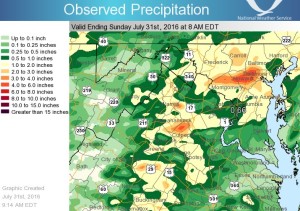
Precipitation that generated the 2016 Ellicott City flood. Ellicott City is in the reddest area, just to the west of Baltimore. (Image from the NWS.)
Clearly, convective storms can produce floods, and Ellicott City has terrible luck. But is it all bad luck? While the rainfall amounts from these storms are really big, if they’d happened in flat, sandy, forested areas, the resulting floods would have been much smaller. Unfortunately, historic downtown Ellicott City sits at the bottom on a locally steep valley that gathers runoff from three little tributary streams. And upstream, there is a lot of urban development. Ellicott City’s floods illustrate that the topography matters – the faster water runs down slope and gets collected into channels, the worse the flood will be, because more water will be entering the stream at once. Land use also matters, but for really extreme events, its signal is a little harder to parse, because if it rains hard enough or long enough, few landscapes will be able to infiltrate all of the water. Land use matters more for small floods.
Mesoscale convective complexes = flash flooding in multiple streams + downstream floods
Some convective storms are much larger than normal, and we call these “mesoscale convective systems” or “mesoscale convective complexes.” Mesoscale systems can have diameters of 10s to 100s of kilometers, and they can be major flood generators with impacts over much larger area than the isolated convective storms. The worst floods occur when large-scale atmospheric circulation patterns cause a mesoscale convective systems to stall out over a particular area, with thunderstorms popping up over and over again for hours or days. Isolated convective storms generally only cause floods for small streams, but an important feature of floods caused by mesoscale convective systems is that they affect more than one localized area, so they can create floods on larger river systems within or downstream of the area where rainfall occur.
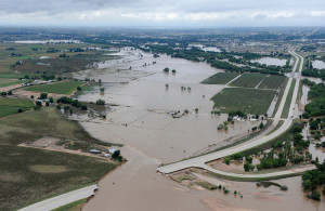
A stalled out mesoscale convective system over Colorado’s Front Range in September 2013 caused over 450 mm of rainfall in one week, resulting in over $2 billion dollars in flood damage and hundreds of landslides. Flooding started in mountain canyons where over 300 mm of rain fell in one 24 hour period alone. As all of that water drained onto the flat-lying plains, flooding continued for days in the South Platte River and its tributaries. Flooding occurred because of infiltration-excess and saturation-excess overland flow. Rainfall probabilities for this event are estimated to be >1/1000 years (though that’s extrapolating well beyond the data), but flooding probabilities are not quite that extreme, with most of the places where gages exist or estimates made having floods with a 1/50 to 1/500 year probability.
As with isolated convective systems, mesoscale systems can create bigger floods where topography is steep and there are lots of channels to quickly move precipitation falling on land into a stream network, resulting in more water arriving in the same part of a river at the same time.
Tropical and extra-tropical cyclones = flooding for miles and days
Tropical cyclone is the general term for hurricanes (wind speeds >74 mph), tropical storms (wind speeds 39-73 mph), and tropical depressions (wind speeds
Tropical cyclones are notorious flood generators, and inland flooding is the leading cause of death from these storms in the US. Hurricane categories only consider wind speed, not rainfall, so people may under-estimate the hazard associated with lower category storms. Immense rainfall totals can result as moisture is supplied to the storm by nearby ocean waters or by flooded and saturated soils on land. This makes slow moving hurricanes particularly dangerous flood generators, and it’s a reason that people are very concerned with the possibility that climate change could be contributing to slower hurricane movement after landfall. The most sobering example of slow-moving hurricane flooding in the recent past is Hurricane Harvey and its impacts on Houston in 2017. I wrote about the climate change connection and the land use connection at the time. Many fingers were pointed as Houston’s urban sprawl for worsening the disaster, and in some ways that’s fair (houses in floodplains are bad), but in other ways it’s not (almost nowhere can receive 1270 mm of rainfall in a few days without experiencing saturation and flooding).
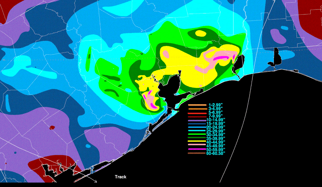
Rainfall from Hurricane Harvey in the Houston area. By David M. Roth; NOAA WPC – http://www.wpc.ncep.noaa.gov/tropical/rain/harvey2017.html, Public Domain.
When tropical cyclones produce flooding in flat areas, like coastal plains along the East Coast and Gulf of Mexico, the floods can last for weeks. We’ve seen this repeatedly in the US, including prominently in North Carolina in 2016, following Hurricane Matthew.
Where tropical cyclones meet steep topography, spectacular flood destruction can result, such as when Hurricane Irene hit Vermont in 2011. Even though Irene dumped less rain on Vermont than where it first made landfall in North Carolina, the flood effects were much worse. A similar phenomenon happened just a week later in the Susquehanna River watershed, as a result of Tropical Storm Lee. In fact, those two storms prompted my first “recipe” for flooding: Take a tropical cyclone and add steep topography.
Atmospheric rivers + orographic lifting = a major source of floods for California and the Pacific Northwest
Atmospheric rivers are narrow bands of concentrated moisture coming off the ocean and onto land. They are an area of active research as we increasingly recognize how important they are for generating floods and building snowpacks in the Western US. Here’s a great explainer video:
A key thing about atmospheric rivers as flood generators is not just how much water they carry, it’s what happens as they are orographically lifted over steep terrain like the Coast Range, Cascades, and Sierra Nevadas. That lifting and cooling causes the moisture to come out of the sky and fall as rain and snow. If conditions are cold enough to form snow, skiers rejoice and hydrologists and emergency managers let out a sigh of relief. But often, the atmospheric rivers are coming from the tropical ocean, in what we call a “pineapple express”, so the moisture is not just abundant, it’s warm. Then, the precipitation falls as rain, even at high elevations, and we get floods. If an atmospheric river happens after snow accumulates in the mountains, it will melt some or all of the snow and we get even bigger floods.
I’ve written about the effects of atmospheric rivers on Oregon’s Mt. Hood on more than one occasion. Flooding in 2011, was relatively minor as far as these things go. In 2006, a similar storm caused more extensive flooding and landslides on Mt. Hood, affecting my own research. The same storm, caused problems from Central Oregon all the way up to Mt. Rainier, south of Seattle. That gives you some idea of the scale of these systems and their effects.
Californians care a lot about atmospheric rivers, because they depend on mountain snowpacks and reservoirs to provide water for farms and people living in lower, warmer, and drier locations. But too much of a good thing is a flood. And climate change is projected to increase the intensity of atmospheric rivers affecting California and could even set up a scenario called the ARkstorm (for 1/1000 probability, atmospheric river storm). Watch the video below, because the consequences of this possible event are too big just to put into words, and yet, what could happen is based on state-of-the-art science and historical records of the 1861-1862 flood that inundated nearly the entire Central Valley.
Monsoons = Weeks-long rains and sometimes floods
As the Intertropical Convergence Zone (ITCZ) shifts north and south across the Equator, the direction of air flow towards it changes too. Whichever way the wind is blowing, where the warm moist air from over the oceans blows onto even hotter land, it rapidly rises, cools, and begins to rain. The seasonally shifting wind direction and associated wet-dry periods is called a monsoon climate, and monsoon climates are particularly pronounced around the Indian Ocean. In the northern hemisphere winter, the ITCZ causes monsoon rains in northern Australia, while in northern hemisphere summer, the rains are affecting south Asia. During the Asian monsoon, orographic effects as air lifts over the Himalayas increase the intensity of the rainfall. If you’ve spent time in the southwestern United States, you may also be familiar with monsoon rains in that region.
Monsoon rains bring an average of 900 mm of rain to India each year. Spread out over the months of June to September, the rains are an important water source for crops, livestock, and humans, and helps offset the opposite season, when hardly any rain falls.
But when monsoon rains come in intense downpours, flooding can result. Some years, more rain falls or a lot of rain falls in the space of a few weeks, rather than more evenly spread out over months. In ways that we don’t completely understand, climate change seems to be making the monsoon rainfall less moderate and more sporadic. Dry periods interspersed with extreme precipitation periods are becoming more likely and that means that floods are becoming a more frequent part of the monsoon climate.
Monsoon flooding was a major problem in India in 2019, and this article (not by me) does an amazing job of linking monsoon dynamics to climate change and increasing risks experienced by growing urban populations.
In 2010, monsoon flooding hit Pakistan hard. Monsoon rains poured over one mountain region for weeks, causing flooding and landslides, followed by slow downstream flood wave propagation along the Indus River for weeks longer. More than 18 million people were affected by this flood alone, and it appears that the location of the flood-producing rains was shifted relative to historic patterns, yet another flood-related consequence of climate change.
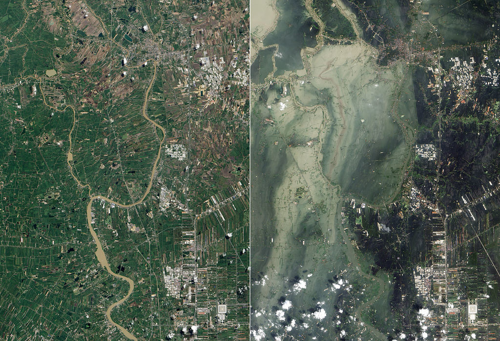
Monsoon flooding along the Chao Phraya River in Thailand, with July 2011 (left) and October 2011 (right) compared. Images are from NASA, via Wikipedia.
Important notes and take away points
These aren’t the only ways to cook up floods. First, I’ve only covered meteorological floods on rivers in this post, and then, I haven’t even covered all of those. Frontal systems can produce floods too, particularly if the ground is wet to begin with or if infiltration capacity is low. And rain-on-snow is a significant flood generator (even without the concentrated fire power of an atmospheric river) because the heat from the rain can melt large amounts of snow, dramatically increasing the volume of water contributing to a flood.
Climate oscillations like the El Niño-Southern Oscillation and Pacific Decadal Oscillation will exacerbate these flood generation recipes in some years and some regions, and mute them in other places. The climate oscillations don’t create flooding in-and-of themselves, but they can make things better or worse.
The recipes above will generate floods that vary in space and time scale of impact – from affecting headwater streams for a few hours to affecting huge river basins for months. In general, the highest intensities of rainfall will only affect a fairly small area for a fairly short amount of time, but mechanisms that produce more prolonged rainfall can cause widespread flooding, even if the intensity is lower.
Topography matters. Steep slopes route water quickly into streams producing high peak flows, while flat areas drain slowly resulting in floods that last much longer.
Land use matters – to some extent. In really extreme rainfall, it may make little difference in the peak flow and total flood volume, because the landscape would have been overwhelmed regardless of landcover. For smaller floods, land use, including deforestation and urbanization, definitely matters, and land use also matters quite a bit for things like landslides which often accompany floods. Regardless of size, a flood is a disaster when people are in the way, and land use is one rough proxy for how many lives and how much property is likely to be affected.
Climate change is affecting the frequency and/or severity of floods across all of these recipes, even if we can’t always detect the signal of climate change in a particular event. In general, we are seeing – and expect to continue to see – increases in extreme rainfall, the key ingredient in all of these recipes. And extreme rainfall intensity is increasing much faster than the overall increase in atmospheric moisture and mean precipitation. We are also seeing shifts in timing and location of flood-generating storms.



Nice plan for content warnings on Mastodon and the Fediverse. Now you need a Mastodon/Fediverse button on this blog.