
![]() There’s been a lot of speculation and discussion about the role of urbanization in contributing to the flooding from Hurricane Harvey in Houston. Fortunately, urban hydrology is my specialty, so even though I’ve never been to Houston, I feel like I can offer some insights. (Also, read part 1 on the climate change aspects of this disaster.)
There’s been a lot of speculation and discussion about the role of urbanization in contributing to the flooding from Hurricane Harvey in Houston. Fortunately, urban hydrology is my specialty, so even though I’ve never been to Houston, I feel like I can offer some insights. (Also, read part 1 on the climate change aspects of this disaster.)
Many of the damaged buildings were outside designated “100-year” floodplains. Why is that?
First, given that Harvey produced more rainfall than the contiguous US had ever before recorded from a single storm (51.88″ in one location), I think it’s safe to say that this storm has historically had a <<1% chance of occurring. In other words, based on historical data, we wouldn’t expect this storm to occur 1 time in 100 years in Houston, because nothing anywhere near has been has ever occurred before. But, history of course, is not a very good guide to a climate-changed present and future (see below).
Second, the FEMA maps are out of date in many areas. Not only do they not consider climate change, but they only account for the level of urbanization that has occurred at the time the map is made. They don’t take into account planned or projected future urbanization, levee building, etc.*
Yet, these maps aren’t updated very regularly and can be a decade or more out of date in some areas (mostly rural). Plus, local politicians don’t want to show that a large part of their community is in a floodplain (and require more expensive buildings and flood insurance), so there’s local pressure to keep delineated floodplains as small as possible. Finally, it doesn’t help, that the flood mapping program has always been under-funded and is a popular target for funding cuts.
We need to wrap our head around the scale of the damage. There are at least 90,000 residential structures damaged in 3 Texas counties, based on an early FEMA estimate. Harris County (where Houston is) officials are estimating up to 136,000 homes destroyed. I’ve seen one estimate that 40-50% of the damaged homes are located outside the mapped floodplain.
Did urbanization and impervious surface make flooding worse?
No. Impervious surface (pavement and rooftops) prevents infiltration. But there isn’t a landscape in the world that can take 50” of rain and infiltrate it without flooding (or landslides). Even if your landscape can infiltrate whatever rainfall is landing on the surface, the soil will wet up from the bottom as water tables rise toward the surface. And when the water table is at the surface, it doesn’t matter what your infiltration capacity is, water can’t move down.
Furthermore, Houston is in the Coastal Plain, which is made up of lots of fine-grained sediments, notoriously poor for infiltration. Southern Harris County’s soils are classified as group D, meaning that they are the worse of four classes of soil for infiltrating water.
Yes. Urban development that encroaches on natural water storage areas – floodplains and wetlands – makes flooding worse elsewhere. (And more to the point, it puts people and property in harm’s way.) If you fill in the low areas, install drainage pipes to shunt water elsewhere, or build levees to keep water off the floodplain, then that water has to go somewhere, and in fairly flat areas like Houston, that somewhere will become everywhere. Houston and its suburbs have faced criticism for rampant wetland destruction and for building whole neighborhoods in designated floodplains. The New York Times has a fantastic set of animated graphics that show how development overlays with floodplains in the Houston area (and how flood damages from Harvey aren’t restricted to mapped floodplains. I’m taking the risk of reproducing two screenshots below that I think are particularly good example of this phenomenon.
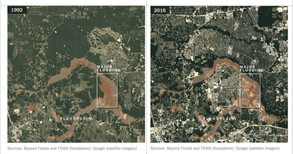
Development on a Houston area floodplain. via New York Times (click the link above and read their article too)
Won’t insurance pay for the damage to people’s houses?
Only if you have flood insurance, because standard homeowners and renters policies don’t cover flood damage. If you live in the 100-year floodplain and have a mortgage on your house, you are required to buy flood insurance, which can run $1000s per year. If you don’t live in a designated 100-year floodplain, flood insurance is totally optional. It’s also less expensive, since your risk of flooding is lower, but who among us says “Sure, I’ll buy totally optional insurance at a cost of several hundred dollars per year for something the government says isn’t going to happen at my house?” In all likelihood, the majority of Houston-area flood victims will not have any flood insurance to pay for their lost possessions and houses.
For those who do have flood insurance, the National Flood Insurance Program (NFIP) will help pay for them to repair and rebuild – in the same risky location. One percent of properties insured by the NFIP take up 25-30% of its payouts. The program loses money every year, and US taxpayers foot the bill.
Can we engineer our way out of disasters like this?
Stormwater management is not designed for extreme events. Most stormwater control measures are designed for the type of storm that happens a few times per year. In Harris County, stormwater controls have what’s called a “water quality volume” that is designed to treat 1.5″ of rain in 24 hours. Anything above that does not have to be detained or infiltrated by the stormwater control. Remember, the whole Houston metro area got >30″ of rain over 5 straight days and a new contiguous US record of 51.88″ was set in one location. Why aren’t stormwater controls designed for bigger storms? It would cost more and they would take up more valuable real estate. And most of the time, that extra storage wouldn’t be put to use. (Of course, it doesn’t help if a large number of your stormwater controls aren’t performing up to design standards.)
Flood control reservoirs work, to a point, but then they run out of storage volume and might even make things worse. Flood control reservoirs might be designed to reduce the effects of the 100-year flood, which has a 1% chance of occuring in any given year. For the Houston area, the 1% rainfall is 13” of rain in 24 hours. But that’s happened >8 times in last 27 years, so clearly the math is a bit off (likely out of date, thanks in part to climate change). Houston has two flood control reservoirs, Addicks and Barker, built in the 1930s, that sit dry until a flood comes along. Of their 10 highest levels, 9 have happened since 1990 and 6 have happened since 2000 (and that was before Harvey). When Harvey roared in, the reservoirs filled up completely and over topped for the first time in their history.
After flood control reservoirs are full, they can’t help store any additional rainfall and runoff. Plus, management operations will swiftly turn from storing the flood to protecting the structural integrity of the reservoirs. Meaning that the dam operators will start to release extra water downstream – even though that makes downstream flooding worse – because they don’t want the dam to fail. You don’t want a 100-foot high wall of water rushing towards downtown Houston either. The Houston reservoirs were forced to release water during the height of the flooding, making things worse in downstream neighborhoods. But dam failure is a risk that no engineer or hydrologist is willing to take.
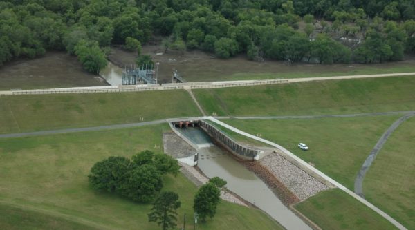
What Barker Reservoir looks like empty. (US Army Corps of Engineers photo, public domain.)
Just like with stormwater controls, we don’t build flood control reservoirs for the most extreme events, because designing bigger capacities to accommodate a rare storm increases costs dramatically. This is particularly true in a flat area like Houston, where every additional foot of height on a dam means a much larger footprint for the reservoir, locking that area away from development.
Levees – walls built between the river and neighborhoods – might work locally, but they make flooding worse elsewhere. And like every other form of engineering, they can be under-designed for extreme events. And they can fail.
So what can be do to avoid a disaster like this in the future?
- Stop filling wetlands. Support wetland restoration and mitigation efforts.
- Don’t (re)build in floodplains. (Even beyond the official 100-year floodplain.)
- Consider the likelihood of enhanced flooding from increased precipitation intensity and sea level rise when making rebuilding and future development decisions.
- Develop smart, staged evacuation plans for the most flood-risky areas and for vulnerable populations.
- Advocate for enhanced funding for FEMA’s flood mapping program.
- Revamp the National Flood Insurance Program.
- Take immediate action (individually and collectively) to reduce the greenhouse gas emissions that are causing climate change.
*A reader alerted me to this 2001 FEMA rule on “Future Conditions Hydrology” which says that at the request of a community, for information purposes only, the maps can reflect future conditions data, as generated by the community, in addition to the current 100-year (1%) “base flood elevation.” Areas outside the current 1% floodplain, but inside the future 1% floodplain are designated as area X. In those areas, homeowners are not required to buy flood insurance by federal rules, though a private lender could make that requirement. Similarly, under federal rules, structures would not have to be elevated, though local laws might require flood production in these areas. “Future conditions hydrology means the flood discharges associated with projected land-use conditions based on a community’s zoning maps and/or comprehensive land-use plans and without consideration of projected future construction of flood detention structures or projected future hydraulic modifications within a stream or other waterway, such as bridge and culvert construction, fill, and excavation.” Note that “public works in progress including channel modifications, hydraulic control structures, storm drainage systems and various other flood protection projects” had been considered in the FEMA maps since 1995. The TL;DR of all of this is that IF a community requests future conditions be displayed, and does the legwork of figuring out what those future conditions are, they do appear on maps generated since 2001, but they are not federally enforceable.
Comments (1)
Links (1)-
Pingback: Hurricane Harvey and the Houston flood: Did Humans Make it Worse? (Part 1: Climate Change) | Highly Allochthonous