
NASA’s Earth Observatory put out this great image last week, which shows the ground displacement in Nepal resulting from last month’s devastating magnitude 7.8 earthquake, which has claimed at least 8,500 lives. The vertical displacements have been calculated by comparing radar altimeter data from satellite passes before and after the earthquake happened.
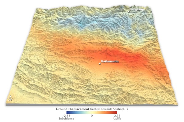
Displacements in land surface due to the M7.8 Gorkha earthquake, measured by satellite radar altimetry. Source: NASA
One of the striking things about this image is how, even if this was the only information you had about the earthquake – no geological cross-sections, no focal mechanism – you could still tell that you are looking at the results of a large rupture of a thrust fault that shallowly dips to the north. The broad zone of uplift in front, with an equally broad zone of subsidence behind, is a clear signature of this kind of structure. To understand why, you first have to think about what is happening in the build up to this earthquake. Plate tectonic forces are constantly driving India northwards, thrusting it under the Eurasian plate. The contact is a gently northward dipping fault zone that is usually locked by friction down to depths of 15–20 km or so; this means that the motion of the underlying Indian plate will also drag crust on the overriding Eurasian plate down and to the north with it, causing subsidence above the locked portion of the fault. This effect dies off further north as the fault gets deeper and weaker – higher temperatures mean ductile rather than brittle deformation dominates, so the fault is no longer ‘strong’. In this region, land squashed between India-driven motion to the south, and strong Eurasian crust to the north, is squeezed pushed upwards.
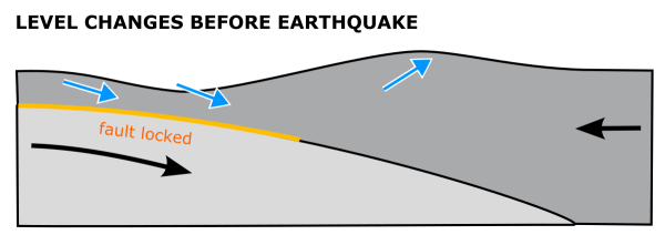
Deformation of the land surface above a frictionally locked, shallowly dipping thrust fault. Subsidence above the shallow part of the fault is balanced out by uplift down-dip of the locked zone.
However, this is (mostly) elastic strain – remove the forces causing this change of shape, and it will bounce back to its original shape. This is exactly what happens when the accumulated strain across the fault becomes large enough to overcome its friction, and it ruptures in an earthquake. The region above the previously locked thrust pops back up as it catches up with decades or centuries of plate motion; and the uplifted crust to the north drops back down as the tectonic vice it was caught in relaxes.
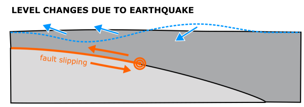
Deformation of the land surface associated with a large earthquake on a shallow thrust fault. Release of accumulated strain causes uplift above the shallow part of the fault and subsidence further down-dip.
To make things even clearer, you can quite nicely project my schematic cross-section above onto the broad patterns of uplift and subsidence seen in the radar data.
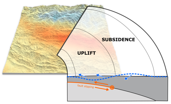
How the pattern of land displacement measured by radar altimetry matches up well to the pattern expected from an earthquake on a shallowly dipping thrust fault.
What makes this even more impressive is how quickly we have this picture – a few decades ago, you’d need months – or years – of levelling surveys to work out how the land surface had changed elevation after a major earthquake. Now we’re only limited by how soon an orbiting radar satellite is going to pass overhead.