
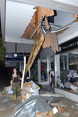
When I was out in New Zealand doing fieldwork for my PhD, I spent most of my time based in Gisborne, a sleepy little town on the east coast of the North Island. Over Christmas, it seems that Gisborne was shaken by a strong (magnitude 6.6) earthquake. It’s quite weird seeing pictures of damage to buildings I recognise – for example, I’ve bought stuff from this store:
Seismic activity in this region is not really too much of a surprise, though. The boundary between the Pacific and Australian plates runs right through New Zealand, with the North Island being parked right on top of a subduction zone which begins at a trench about 50-100 km offshore from the east coast (Gisborne is marked by the circle; the epicentre of the December earthquake is located about 50 kilometres southeast of this, between the coast and the trench:
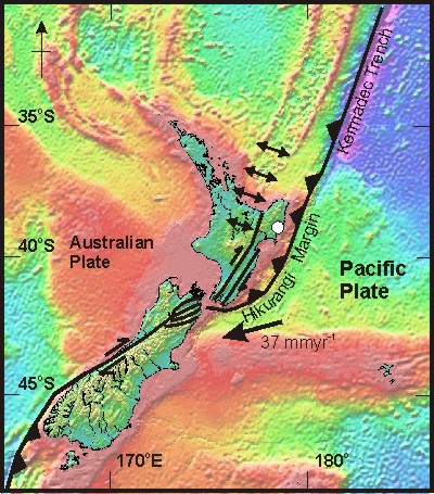
The moment tensor solution indicates an extensional earthquake at a depth of about 30 km, quite a lot deeper than the subduction thrust at this location, so it looks a lot like this tremor is related to bending of the Pacific plate as it is subducted beneath the North Island.
What’s really interesting about this region is that a large proportion of the relative plate motion between the Pacific and Australian plates is not actually accommodated by slip at the subduction zone, but by deformation of the forearc region behind it. You can see a hint on this in the figure above, which shows some large strike-slip faults on the southern North Island – one of which runs right through the capital, Wellington. My PhD was spent investigating some aspects of this more distributed deformation; in the run up to the (hopefully) imminent publication of a paper which discusses my findings, I’ll be returning to the tectonics of New Zealand again in the next few weeks.
Comments (2)