![]()
![]() Interpreting the record of the Earth’s magnetic field preserved in rocks – palaeomagnetism – is a complicated business, but at the heart of it is one very simple assumption: except when it is reversing, if you average over a few thousand years or so, the geomagnetic field resembles a dipole aligned with the Earth’s geographic poles.
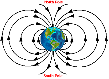
Interpreting the record of the Earth’s magnetic field preserved in rocks – palaeomagnetism – is a complicated business, but at the heart of it is one very simple assumption: except when it is reversing, if you average over a few thousand years or so, the geomagnetic field resembles a dipole aligned with the Earth’s geographic poles.
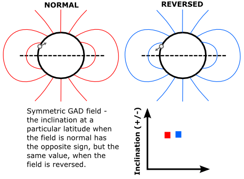
This relatively uncomplicated shape means that there is a very simple relationship between latitude and the magnetic inclination (the angle magnetic field lines make with the horizontal); it is zero at the equator, and gradually increases to 90 degrees at the poles. If you measure the direction of the fossil field direction carried by rocks at a particular site, a simple formula converts the inclination of this ancient magnetisation into the palaeolatitude of that particular chunk of crust at the time the rocks formed. Because the field is symmetric, a reversal changes the polarity, but not the shape, of the field; for example, an inclination value of 50 and -50 degrees both always correspond to a latitude of 30 degrees.

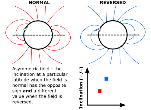
But what if our simple assumption is wrong, and the Earth’s magnetic field has not always been a dipole? There are more complicated quadropole and octopole components in the present geomagnetic field, but they are fairly minor and, except during a magnetic reversal, seem to average out to zero over a few thousand years. But what if at some point in the geological past these components were not only a more significant part of the geomagnetic field, but also did not average to zero over geological time? This would produce an asymmetric long-term field geometry, as in the figure below, where 15% of the earth’s magnetic field energy is in the quadropole component. For a point at mid-to low northern latitudes, rocks forming in a normal polarity field would have a shallow magnetic inclination, whilst rocks forming in a reversed polarity field would have a much steeper inclination. The warped field geometry means that there is no longer a one-to-one relationship between inclination and latitude, which makes working out the plate motions recorded by all of those ancient magnetic directions much more difficult.

For the last 200 million years or so, we know that our uniformitarian assumption that the Earth’s magnetic field has always been a geoaxially-centred dipole holds true; we have lots of good palaeomagnetic data from every continent, and we can check palaeomagnetically determined palaeolatitudes against the continental positions estimated from undoing sea floor spreading. Further back in time, however, data are more sparse, and independent checks are much harder. Amongst these older data one study stood out: within the 1.1 billion year-old Keweenawan lavas, which outcrop on the shores of Lake Superior, flows with both normal and reversed polarity magnetisations were found, indicating that the Earth’s magnetic field reversed during the 11 million years of rifting that produced them. However, the directions were clearly asymmetric; the reversed polarity direction was more than 20 degrees steeper than the normal polarity one. Was this evidence of a not-so-dipolar magnetic field in the late Proterozoic?
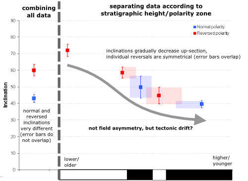
In the 30 years since these data were published, the period between about 1200 and 600 million years ago has emerged as a rather interesting time in Earth history, covering the amalgamation and breakup of the supercontinent Rodinia and the onset of at least two severe, possibly global, glaciations (the ‘Snowball Earth’). An asymmetric magnetic field at this time would introduce a great deal of uncertainty into palaeogeographic reconstructions, making it much harder to work out what was going on; so finding out if the Keweenawan lavas actually do record an asymmetric field, by subjecting them to closer palaeomagnetic scrutiny, has suddenly become much more important. In a study recently published in Nature Geoscience, Nicholas Swanson-Hysell and his colleagues present the results of some much more detailed sampling of the lavas. They found that the Keweenawan section records not one, but three magnetic field reversals. As in the earlier study, they found that when all the results were combined, the mean of the reversed polarity magnetisations had a much steeper inclination than the mean of the normal polarity ones. However, when directions from each sampling site are considered separately, another pattern emerges: inclination values steadily decrease as you move from older rocks to younger ones. This is true even for rocks of the same polarity; older lava flows with a normal polarity magnetisation have steeper inclinations than younger normal polarity flows, and the same is true for reversed polarity flows. Most important, however, is what you see when you compare the directions recorded by lavas erupted just before and after a polarity reversal: for all three reversals, the normal and reversed polarity directions have the same inclination, within error.

In other words, each individual reversal is symmetric, and the previously reported magnetic field asymmetry is actually a result of a kind of sampling bias. During the eruption of the Keweenawan lavas, the field mostly had a reversed polarity during the earlier stages and a normal polarity in the later stages. The gradual decrease in inclination values also indicates that North America was gradually moving south, from higher to lower latitudes, as the eruption progressed. The combination of these two factors mean that most of the older lavas have steep reversed magnetisations and most of the younger lavas have shallow normal magnetisations – and hence their mean values are very different.
So it seems, as is often the case in palaeomagnetism, the devil is in the detail: what initially looked like proof of weird Proterozoic magnetic field geometries turned out on closer examination to show fairly convincingly that a billion years ago the geomagnetic field was just as dipolar as it is today. However, before the hardcore uniformitarians start their victory dances, they might want to look more closely at the palaeomagnetic data in the figure above. The change in inclinations through the section indicates that North America moved almost 30 degrees – around 3000 kilometres – southward in just 11 million years of volcanic activity. This means that the plate that it was located on was travelling at a speed somewhere between 20 and 40 centimetres a year, which is significantly faster even than India prior to its collision with Asia. Rather intriguingly, we may have replaced one geological mystery with another.

Geotagging (View all geotagged posts)
Swanson-Hysell, N., Maloof, A., Weiss, B., & Evans, D. (2009). No asymmetry in geomagnetic reversals recorded by 1.1-billion-year-old Keweenawan basalts Nature Geoscience, 2 (10), 713-717 DOI: 10.1038/ngeo622


Comments (9)