Friday(ish) Focal Mechanisms

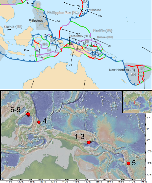
A post by Chris Rowan Yes, yes, I know it’s Saturday. I was running a bit late this week anyway, and then there were 3 magnitude 7s beneath the Philippines to have a look at. Indeed, there has been lots of seismic action in the Papua New Guinea region this week. The area is very complicated tectonically: it’s a collisional belt involving a number of small microplates interacting with each other.

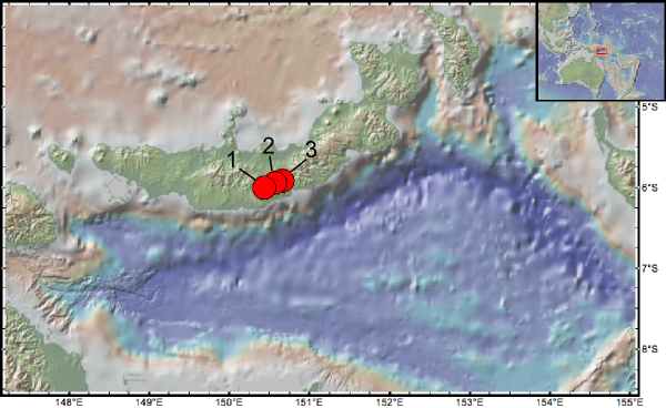
At the beginning of the week, there were three large shocks beneath New Britain, where the Solomon Sea plate is subducting northward beneath the Bismarck Sea plate.


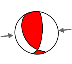
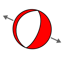
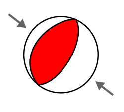
1. 18th July, Magnitude 6.9; Depth 42 km
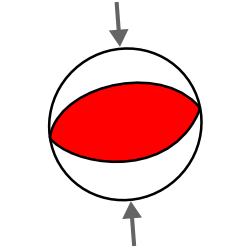
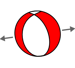
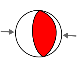
Focal mechanism indicates E-W compression.
USGS Page

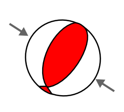
2. 18th July, Magnitude 7.3; Depth 35 km
Half-hour after the M6.9. Focal mechanism indicates N-S compression.
USGS Page

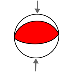
3. 20th July, Magnitude 6.3; Depth 54 km
Focal mechanism indicates N-S convergence
USGS Page
Given the extremely close proximity of these 3 earthquakes, they could be regarded as a foreshock-main shock-aftershock sequence (although obviously, there are many smaller aftershocks associated with the sequence as well). The latter two earthquakes are consistent with shortening at or near the subduction interface; the first earthquake, though, indicates convergence perpendicular to this. This seems a little odd; the rupture may be deep enough to be in the subducting plate, and appears to show some kind of lateral squashing. However, I actually blogged last September about a similar earthquake beneath Indonesia, so perhaps it’s not so unusual in this region after all.

Later in the week, there were also large shocks a few 100km to the east and west of the New Britain sequence. I note these with the usual caveat that while nearby large earthquakes might have given a little nudge to areas that were already on the verge of rupturing, proving any direct connection is exceedingly difficult.


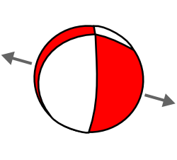
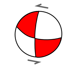
4. 21 July, Magnitude 6.1, N of Halmahera, Indonesia; Depth 102 km
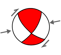
E-W compression, but with a large strike-slip component. The latter might be related to the fact that this earthquake is associated with a subduction zone (the Philippine plate moving westward beneath the Sunda plate) that appears to be offset by a transform fault just to the south of the rupture.
USGS Page

5. 22 July, Magnitude 6.2, Vanuatu; Depth 35 km
Focal mechanism indicates E-W compression, so is clearly associated with eastward subduction of the Australian plate beneath the arc.
USGS Page
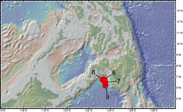
Then, last night, seismometers witnessed 3 large >M 7 earthquakes, very deep in the mantle, below the Moro Gulf near the Philippines, with a smaller 6.5 in the early hours of this morning:


6. 23 July, Magnitude 7.3; Depth 605 km

7. 23 July, Magnitude 7.6 Depth 576 km
50 minutes after M7.3

8. 23 July, Magnitude 7.4; Depth 616 km
25 minutes after M7.6.

9. 24 July, Magnitude 6.5; Depth 564 km
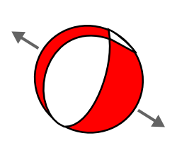
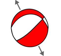
All four focal mechanisms indicate NW-SE extension. Like the Halmera earthquake, this sequence appears to be linked to the westward subduction of the Philippine plate beneath the Sunda plate, with the earthquakes taking place in a deeply subducted part of the Philippine slab. The extension is probably the result of down dip tension as the slab sinks into the mantle, with the first shock apparently triggering similar events above and below it.

Notes:

Categories: earthquakes, focal mechanisms, tectonics

Geology on an epic scale: the Yellowstone caldera

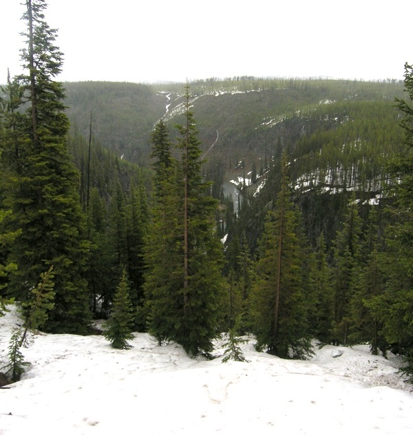
To those with even a little geological knowledge, the view that presents itself as you drive into Yellowstone National Park through the South Entrance may not be quite what you expect. The park encompasses the giant caldera of a hotspot-fuelled ‘supervolcano’ that last exploded 630,000 years ago, and is famous as the place to see geysers, hot springs and other hydrothermal activity, all powered by that same hotspot. So it is perhaps a little disappointing that all that initially presents itself is a sea of lodgepole pine (and, when I visited, snow on the ground). Pretty, but not exactly…dramatic.

South Yellowstone, near Lewis River

South Yellowstone, near Lewis River. Photo: Chris Rowan, 2010

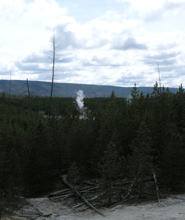
It does not take long, however, for signs of Yellowstone’s unique volcanic nature to make themselves apparent. In places, the pine-filled horizon is broken by rising plumes of steam from geysers and hot springs.

Geyser, Norris Basin. Photo: Chris Rowan, 2010

In some regions, the forest gives way completely to a bubbling, steaming hydrothermal wasteland.

Firehole River, near Upper Geyser Basin (click for larger version). Photo: Chris Rowan, 2010

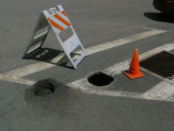
Indeed, the whole area is dynamic and ever-changing: new hot springs and fumaroles can pop up almost anywhere.

A new vent burns through a parking lot. Photo: Chris Rowan, 2010

However, despite the ample evidence of the large amounts of thermal energy just beneath your feet, the fact that you are effectively standing in the crater of a giant volcano remains a bit abstract and difficult to grasp, mainly because you can’t easily see that crater. The big hole in the ground left by the last explosive eruption 630,000 years ago has been largely filled in by later eruptions of rhyolite lava; the topography has been smoothed by the waxing and waning of ice sheets during recent glaciations. During my visit, I was on the lookout for a large cliffs that might mark the caldera rim, but although there were cliffs aplenty, they generally turned out to be formed of (relatively) young rhyolite.

Rhyolite cliffs overlooking Madison River, W Yellowstone (click for larger version). Photo: Chris Rowan 2010

This does give an inkling of the scale of the geological forces at work in this region: the cliff photographed above represents a ‘minor’ flow that followed the last big explosive eruption, yet it is still getting on for 100 m high. But to really get to grips with the scale of the geological processes operating in Yellowstone, actually standing in it is perhaps not the best vantage point. You really need to take a much wider view:

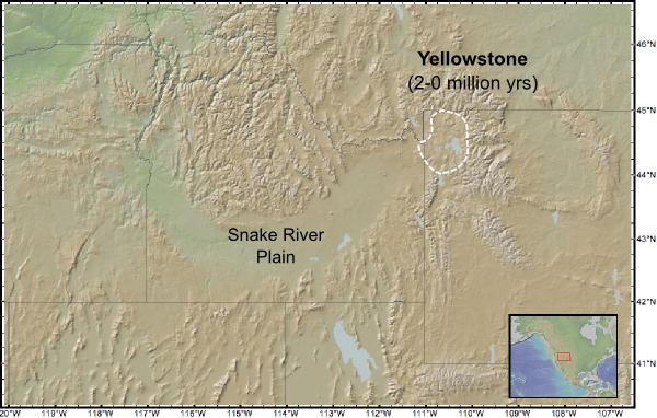
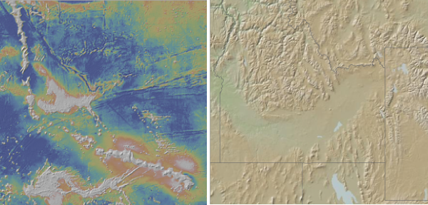
Topography of the area around Yellowstone, including the Snake River plain

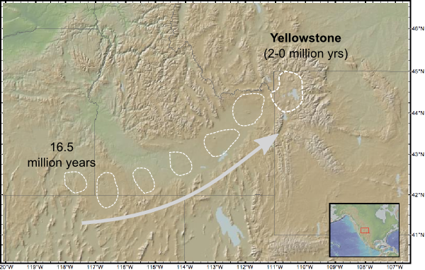
If you look at the topography of the northwestern US, the Snake River Plain rather noticeably stands out as a wide channel cutting right through the Rocky Mountains. But this feature was not carved by any river. It is underlain by a line of now-extinct calderas: the oldest, to the west, was active more than 16 million years ago, and they get progressively younger to the east before the line intersects the active Yellowstone caldera.

Path of the Yellowstone hotspot

The chain of calderas left in the wake of the Yellowstone hotspot.

This line of ancient supervolcanoes records the passage of the Yellowstone hotspot – or, more accurately, the movement of North America over the Yellowstone hotspot – in the last 15 million years or so. Prior to this, the trough that holds the Snake River Plain was not there – the Rocky Mountains formed a continuous chain running from northwest to southeast. That trough has been excavated; the mountains literally blown into dust by massive supervolcano eruptions gradually eating eastward into the Rockies, with the debris spread far and wide across the continental US. This makes the Yellowstone hotspot the evil twin of the one beneath the Hawaiian Islands: above Hawaii, basaltic volcanism builds up mountains from the sea floor; above Yellowstone, explosive rhyolitic eruptions through continental crust destroys them.

Hawaiian and Yellowstone Hotspots

Hawaii and Yellowstone: the Yin and Yang of hotspot volcanism

Fifty years ago, people considered using nuclear bombs to blast through mountain ranges: little did they know that the planet had thought of it first, and on a scale orders of magnitude greater.

Categories: outcrops, photos, volcanoes

Stuff we linked to on Twitter last week

A post by Chris RowanA post by Anne JeffersonBut first, we have some non Twitter links to share.

Blogs in Motion

We haven’t been the only people to change their blog addresses in the past couple of weeks. In fact, there’s a whole feed to keep track of most of them, courtesy of Chris Clarke at Coyote Crossing. We would particularly recommend keeping track of:

We now resume our usual link-sharing service.

Earthquakes

Very interesting article about low-frequency tremor at subduction zones, particularly focussing on an ‘annual’ swarm on the Cascadia subduction boundary.
http://www.nature.com/news/2010/100714/full/466312a.html

1/2 a year after the Haiti quake, only 28k of 1.5 million displaced people have new homes. Real life, real problems.
http://www.nytimes.com/2010/07/11/world/americas/11haiti.html
(via @Revkin)

A Sierra Nevada fault running beneath a dam has been active in last few thousand years, and could produce a M 6.5-7.5 quake
http://www.sfgate.com/cgi-bin/article.cgi?f=/c/a/2010/07/10/BAG51EBH9B.DTL
(via @tpenews)

Volcanoes

Interesting: linking volcanism & deformation away from plate boundaries to mantle flow. Although it seems that ultimately the mantle flow is linked to turbulence caused by subducting lithosphere…
http://www.geolsoc.org.uk/gsl/geoscientist/geonews/page8051.html
(by @geoscientistmag)

Eruptions Word of the Day: Tuya [Sub-glacial volcanism. Sexy.]
http://scienceblogs.com/eruptions/2010/07/eruptions_word_of_the_day_tuya.php
(via @Geoblogfeed)

A volcanic cruise through the Mariana Islands: Pt 1. An Excellent tectonic & volcanic overview of the region.
http://scienceblogs.com/eruptions/2010/07/a_volcanic_cruise_through_the.php
(via @Geoblogfeed)

Fossils

Chris Nedin expands some more on why he thinks the 2.1 Ga fossils from Gabon are not multicellular, but microbial mats.
http://ediacaran.blogspot.com/2010/07/21-ga-multicellular-colonial-organisms_13.html
(via @Geoblogfeed)

Planets

A thing of beauty: compare Lutetia’s size to all the other asteroids (& comets) visited by spacecraft
http://www.planetary.org/blog/article/00002585/
(via @elakdawalla)

Cassini sees Lakes in Titan’s southern hemisphere shrink as its summer progresses.
http://www.physorg.com/news198386810.html
(via @physorg_com)

(Paleo)climate

Coastal cities attract hurricanes? Technically, rough small-scale topography, which can deflect storm paths by ~30km.
http://blog.agu.org/geospace/2010/07/14/cities-magnets-for-disaster/
(via @theAGU)

Correlating 2000 years of Chinese history & climate shows war & unrest driven by temp changes.
http://www.physorg.com/news198301240.html
(via @physorg_com)

Environmental

Can the Amazon Thrive in the 21st Century? Surprisingly, some optimism. Justified? Who knows?
http://dotearth.blogs.nytimes.com/2010/07/15/can-the-amazon-thrive-in-the-21st-century/
(via @nytimesscience)

Ixtoc I spill nr Mexico 30yrs ago; study of impacts stopped too soon, but some clues for the future in the wake of the Deepwater Horizon spill.
http://www.nature.com/news/2010/100714/full/466304a.html

More than 4 years after Lusi mud volcano began to erupt, mud still flowing, exploration company still trying to escape blame.
http://www.latimes.com/news/nationworld/world/la-fg-indonesia-mudslide-20100710,0,6418019,full.story

Fallout from Hurricane Alex continues, as these @NASA_EO images of flooding in northern Mexico show:
http://earthobservatory.nasa.gov/NaturalHazards/view.php?id=44649

Clear Waters, Cloudy Future For California Wetlands, as sea levels rise and the Gold Rush sediment pulse in San Francisco bay wanes
http://www.npr.org/templates/story/story.php?storyId=128113664&f=1007

General Geology

New geological study has set a more accurate age for planet Earth: down from 4.537 to 4.467 billion (this article explains the science very well).
http://www.bbc.co.uk/news/10577055
(via @bbcscitech)

If the earth stood still: the result of stopping Earth’s rotation is an eye-popping redistribution of the oceans.
http://www.esri.com/news/arcuser/0610/nospin.html
(via @drjerque)

Incredible post from @WanderingGaia on the centuries of horrors of silver mining in Bolivia. Geology meets human tragedy
http://wanderinggaia.com/2010/07/11/an-encounter-with-the-devil/

Interesting Miscellaney

Two recent studies show that being an academic mom can be a lot harder than being an academic dad:
http://chronicle.com/blogPost/The-Search-for-Sanity-in-a/25539/
(via @KateClancy)

Tricky ethical choices ahead: whither welfare in the post-peak world?
http://resourceinsights.blogspot.com/2010/07/whither-weak-in-post-peak-oil-world.html
(via @geotripper)

Great post by @morphosaurus: Science education is “helping children realise that science is something that people like them do.”
http://www.ethicalpalaeontologist.com/2010/07/dinosaurs-in-space-how-not-to-get-kids.html

How does a magnet work? With added vuvuzela analogy! Nice analogy, shame about the instrument…
http://somebeans.blogspot.com/2010/07/how-does-magnet-work.html
(via @SmallCasserole)

Fascinating post by @drskyskull: “Freaks & geeks: optical freak waves in the laboratory” with bonus discussion and video of rogue ocean waves
http://skullsinthestars.com/2010/07/13/freaks-geeks-optical-freak-waves-in-the-laboratory/

This article on confirmation bias has great explanation of science as process of idea destruction testing.
http://arstechnica.com/science/news/2010/07/confirmation-bias-how-to-avoid-it.ars
(via @edyong209)

Musings over at RealClimate about different levels of sci communication – should articles be differentiated based on the required level of expertise?
http://www.realclimate.org/index.php/archives/2010/07/information-levels/

South Africans ponder life after the World Cup. SA, as ever, flickers between inspiring highs and depressing lows.
http://www.guardian.co.uk/football/2010/jul/11/south-africa-world-cup

Once more, because it’s important: Drowning Doesn’t Look Like Drowning –
http://mariovittone.com/2010/05/154/
(via @writingasjoe)

Categories: links

Friday focal mechanisms

A post by Chris RowanSince I missed last Friday, this week features the significant earthquakes from the past two weeks. Hopefully the maps help in understanding what’s going on; I’ll be continuing to develop this format in the coming weeks.

Sunday 4th July: Magnitude 6.2, E Coast of Honshu, Japan, Depth 25 km

The focal mechanism indicates NW-SE compression. The rupture is located behind a trench where the Pacific plate is being subducted west beneath the Eurasian plate, and is at approximately the depth of the subduction interface.
USGS Page

Wednesday 7th July: Magnitude 5.5, S California, Depth 16 km

The focal mechanism indicates a strike-slip earthquake, and it’s probable association with the San Andreas Fault system suggests that is is the result of dextral strike slip along a NW-SE trending fault (identified in reports as the San Jacinto Fault). This earthquake is of interest due to a proposed correlation to April’s magnitude 7.2 earthquake further south in Baja California. This placed additional stress on faults in southern California, possibly making them more likely to rupture.
USGS Page

Saturday 10th July: Magnitude 6.3, S of Mariana Islands, Depth 10 km

This focal mechanism indicates strike-slip motion. The rupture is located in the Pacific plate, at a point before it is subducted beneath the Philippine plate at the Marianas trench. If you look at the bathymetry on Google Earth, a NW-SE trending linear feature can be traced through the rupture point; this is possibly an old fracture zone that has been reactivated by compression of the Pacific plate as it approaches the trench.
USGS Page

Monday 12th July: Magnitude 6.2, Antofagasta, Chile, Depth 114 km

The focal mechanism indicates E-W extension, which is somewhat surprising given that this rupture is located inland from the Chilean subduction zone. This could either represent bending of the subducting plate as it is thrust underneath South America, or gravitational collapse in the forearc. The focal depth of 114 km suggests the latter is probably more likely.
USGS Page

Wednesday 14th July: Magnitude 6.5, Bio Bio, Chile, Depth 29 km

The focal mechanism indicates E-W compression. Its location just inland from the Chilean trench, and the relatively shallow rupture depth, clearly associates this earthquake with subduction on the Chilean margin.
USGS Page

Categories: earthquakes, geophysics

Standing up for serpentinite

A post by Chris Rowan Serpentinite is a very striking rock. olive green and glossy, even rather soapy to the touch when fresh, and a vibrant red when weathered, it’s easy to spot when you’re out in the field.
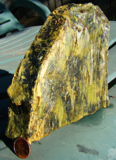
Source: Garry Hayes

Serpentinite is striking visually because it also has quite striking mineralogy. It has a very different composition from most rocks you find at the Earth’s surface: it is far richer in magnesium and poorer in silica. That’s because it wasn’t actually formed at the Earth’s surface, not really: it’s a piece of the Earth’s mantle, originally from 10 kilometres or more beneath the surface. The mantle is mainly composed of a rock called peridotite: if you bring some peridotite up from the mantle and add a bit of water you get the mineral serpentine, which is the principal constituent of the rock serpentinite.

As you might imagine, it takes some pretty extreme geological activity to bring material up from below the base of the crust to the surface. The presence of serpentinite is a badge of tectonic honour, a testament to the extreme deformation suffered by the places it is found. In Oman, it is found where a whole section of oceanic crust has been thrust up onto the continental margin, rather than being subducted under it as it usually is.
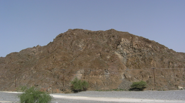
Weathered part of the lower crustal sequence, Oman ophiolite. Photo by C.J. Rowan, 2009

In the Alps and Himalayas, it is found even in the highest peaks, the merest trace of the once vast Tethys ocean that once separated Africa and India from Eurasia before being swallowed up by a vast and ongoing continental collision.
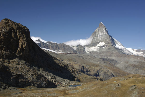
Serpentinite in Alps

Serpentinite body (foreground) near the Matterhorn. Source: UW-Madison Dept. of Geoscience

And you also find serpentinite in California – lots of it. It is the legacy of a time 30 million years ago when, instead of the western part of the state grinding northwards against the eastern side along the San Andreas Fault system, there was instead a subduction zone, where two plates pushed together. In the process, fragments of microcontinents, seamounts and other tectonic detritus was mashed into the eastern coast of California, creating a confusing collage of exotic terranes, and in some cases bringing deeply buried things – like serpentinite – to the surface. It’s presence is one of the major clues that California’s deformational past was very different from what is seen today.

Essentially, serpentinite is like a big red flag telling geologists, “interesting tectonic stuff here!” But in California, that might not be the only red flag that you will be seeing in the future, if the state government have their way. It turns out that serpentinite is California’s state rock (although they actually specify the mineral, serpentine, rather than the rock). As a Brit, I’m not entirely sure what that means, but it certainly hasn’t resulted in any general awareness of what serpentine is, what it represents, and – most importantly in this instance – what it isn’t. California Senate Bill SB 624 is intended to strike off serpentine as the state rock, claiming.

Serpentine contains the deadly mineral chrysotile asbestos, a known carcinogen, exposure to which increases the risk of the cancer mesothelioma.

This assertion is, to say the least, not quite accurate. Chrysotile is one of 20 serpentine group minerals. This variety means that chrysotile is not necessarily a significant constituent of every chunk of serpentinite. Furthermore, ‘asbestos’ is a descriptive term applied to a mineral’s habit, or physical shape – it means that the crystals are long and fibrous. Chrysotile is not the only asbestiform mineral, and whilst prolonged exposure to amphibole asbestos minerals such as tremolite and actinolite have been shown to be strongly linked to mesothelioma, no such link has been proven for chrysotile.

Of course, we can’t expect everyone to be up-to-date on their mineralogy (indeed, I had to look some of this up), and whilst it would have been nice if someone in the State Senate had bothered to check with some geologists before voting the bill through, it doesn’t really matter that much, right? Well, it would seem not: enshrining such erroneous information in law could have considerable legal consequences, given the common occurrence of serpentinite in California. Andrew Alden explains:

SB624’s sponsors are mesothelioma lawyers setting a trap by having the state declare that serpentine, in and of itself, is a carcinogen. This will allow them to rack up billable hours in court whenever anyone—a landowner who wants to shut down a noisy historic railroad line, the owner of a rural hilltop palace who wants developers out of his viewshed, opponents of a new highway—is willing to invoke the “A-word” asbestos on their behalf.

Something fishy is certainly going on with this bill, because as it turns out we shouldn’t be so quick to decry the California Senate’s geological ignorance. The bill they voted through was about composting; it was only after the vote that the bill’s sponsor, Senator Gloria Romero, inserted the anti-serpentine text. You can actually see it for yourself in the online records: compare the description for the bill between April 13 2009, and the description for May 19 2010. Again, as a Brit, I don’t really understand how that’s at all consitutionally valid, but whatever the legalities it certainly smells a little funny.

I’m a little late to this cause, and regular geoblog readers are no doubt aware of how, thanks largely to the efforts of the tireless Garry Hayes of Geotripper, the fuss about this bill has grown on Twitter and is now gracing the pages of the New York Times (if you do need to get up to speed, Silver Fox has a comprehensive collection of links). I can only agree with Garry that education is much better than litigation: actually teaching people about serpentinite will not only prepare them to use caution if they do come across any veins of chrystolite (although they’d have to be returning again and again to pound it up and inhale it to be at any real risk), but will also teach them about all the fascinating geological stories that the presence of serpentinite signposts.

So beware, Californians: if you’re not careful, Texas – blessed, lest we forget, with the stupidest school board this side of the Dark Ages – will be laughing at you. Laughing at you for wasting your time on a non-existent health threat from your state rock, when you have a few slightly bigger problems that need dealing with. But it’s not too late to save yourself from this ignominious fate. The bill has yet to come up to a vote in the California assembly, and there’s always the Governator to lobby – Garry Hayes’ excellent open letter would be a good place to start.

Categories: antiscience, geology, public science, rocks & minerals, science education