
 In July, four geomorphology papers particularly piqued my interest, and, as I started to summarize them, I realized they were loosely connected by a common theme. These four papers all attempt to understand what controls the sediments that make up the streambed and floodplain and that get preserved in the geologic record. White et al. look at how riffle positions are governed by valley width variations, while Jerolmack and Brzinski find striking similarities in grain size transitions observed in rivers and dune fields. Hart et al. examine the relationship between glacial advances and downstream sediment deposition, while Sambrook Smith et al. investigate the sedimentological record of floods.
White, J., Pasternack, G., & Moir, H. (2010). Valley width variation influences riffle–pool location and persistence on a rapidly incising gravel-bed river Geomorphology, 121 (3-4), 206-221 DOI: 10.1016/j.geomorph.2010.04.012
In gravel-bed rivers, channels commonly take the form of alternating pools and riffles. During low flows, pools have deep, slow flow, while riffles are shallow and fast. During floods, pools scour deeper, while riffles may get sediment deposited. This counter-intuitive behavior is explained by channel width variations during high flow – riffles tend to be wider than pools. As the water level rises, valley width may come into play. If the river is confined by valley walls, it will be deeper and faster and able to carry more sediment than where the river is unconfined by the valley walls. By what is known as flow convergence routing, deposition occurs where the river is least width-confined and has the lowest transport capacity. In this paper, White et al. examine the location and persistence of riffles in relation to oscillations in valley width for one reach of California’s Yuba River. Using repeat aerial photography, they show that many riffle crests are located in the widest portions of the valley, and that these riffle crests were persistent for decades. Despite being downstream of several dams, the study reach was geomorphically active – with frequent overbank flows, planform change, and rapid incision (0.16 m/yr), and yet riffles located in the widest parts of the valley remained stationary. Conversely, where riffles were created by large mid-channel gravel bars, and were not in sync with valley width oscillations, they tended to be destroyed by large floods. These results support the idea that flow convergence routing is an important control on pool-riffle channel form and stability and that the common assumption of uniform flow is invalid. Many river restoration practices are based on uniform flow assumptions, and the authors assert that without considering the implications of flow convergence routing, restoration practices are fundamentally misguided.
Jerolmack, D., & Brzinski, T. (2010). Equivalence of abrupt grain-size transitions in alluvial rivers and eolian sand seas: A hypothesis Geology, 38 (8), 719-722 DOI: 10.1130/G30922.1
Rivers generally exhibit downstream fining of sediments – in which the coarsest sediments are found near the headwaters and the finest sediments are found near the mouth. This fining trend occurs exponentially downstream – rapidly in steep rivers as boulders and cobbles give way to gravel-bed streams and much more slowly in low-relief settings where sand and silt can form the streambed for hundreds of kilometers. One interesting phenomenon is that the transition from gravel-beds to sand-beds occurs much more abruptly than might be expected, and many rivers have a deficit of sediment in the coarse sand/fine gravel size ranges (1-10 mm). Downstream fining in rivers has been attributed both to abrasion and to selective deposition of the coarse particles, but laboratory abrasion studies often show much lower rates of downstream fining than are observed in real rivers. Like rivers, wind-blown eolian sediments also exhibit an abrupt grain size transition – between sand and silty loess. Jerolmack and Brzinski (2010) examine the transport and abrasion dynamics of dunes and gravel-bed rivers to understand what mechanisms might be creating the abrupt grain size transition in both systems. Maximum geomorphic work (sediment transport times frequency of the event) in both gravel-bed streams and sand dune fields occurs when Shields’ shear stress is only less than two times greater than the stress required to mobilize the sediment. Similarly, the two systems are comparable in terms of abrasion collision dynamics, as estimated by the collision Stokes number. Abrasion produces smaller particles as big ones collide into each other and chip small pieces off. Abrasion efficiency decreases rapidly as grain size decreases, resulting in a minimum sediment size, which for rivers is in the range of ~10 mm gravel. Meanwhile, the small chipped-off pieces are sand-size (less than 2 mm) and continue to be transported downstream in suspension when the gravel settles out. As Jerolmack and Brzinski conclude “abrasion produces a bimodal grain-size distribution while sorting acts to segregate these grains to produce an abrupt transition.” While the authors acknowledge that the sediment transport in rivers and air are each subject to different constraints, they maintain that their abrasion/sorting hypothesis may explain the longitudinal sediment distribution in both environments. They also propose several additional areas where work is needed to test their hypothesis – including studies of gravel and sand source regions in multiple river systems.
Hart, S., Clague, J., & Smith, D. (2010). Dendrogeomorphic reconstruction of Little Ice Age paraglacial activity in the vicinity of the Homathko Icefield, British Columbia Coast Mountains, Canada Geomorphology, 121 (3-4), 197-205 DOI: 10.1016/j.geomorph.2010.04.011
Paraglacial geomorphology refers to landscape forms and processes that occur in areas adjacent to glaciers and the movement of large amounts of sediment from valley slopes to river systems that accompanies glacial advances and retreats. How rapidly this sediment is transferred from glacial areas to paraglacial areas is of interest to geomorphologists working in alpine and polar landscapes. This paper uses dendrochronology and geomorphic mapping to investigate paraglacial geomorphology and the time lags between glacier activity and downstream sediment deposition in the southern British Columbia coastal mountains. In 1997, a moraine dam overtopped and breached, draining a proglacial lake, and flooding the rivers downstream. The floodwaters eroded through 4 m of paraglacial valley-fill units with in-situ tree stumps and woody detritus. Tree rings from the stumps indicate that they died because of rapid burial by overlying sediment (i.e., from flood deposits). Multiple valley-fill deposits indicate and provide dates for six aggradation events between 718 and 1794, and correlation of these dates with independent regional glacial chronologies suggest that all of the aggradation events occurring during periods of glacier advance. This suggests that river valleys downstream of glacier limits were affected by synchronous redistribution of sand and silt from glacial forefields, moraines, and valley slopes when climates were cold and wet and glaciers were active, and that there was little lag between glacial erosion and advance and sediment delivery to downstream areas. This is paper is cool because it provides data that speak to the rapid delivery of sediment from glacial to paraglacial areas and because it uses trees in the paraglacial deposits themselves to give a much longer dendrochronology than can usually be obtained in glaciated areas.
Sambrook Smith, G., Best, J., Ashworth, P., Lane, S., Parker, N., Lunt, I., Thomas, R., & Simpson, C. (2010). Can we distinguish flood frequency and magnitude in the sedimentological record of rivers? Geology, 38 (7), 579-582 DOI: 10.1130/G30861.1
Over time, the flows that commit the most geomorphic work are those moderately high flows that occur moderately frequently – generally every 1-2 years. But large floods – like those that occur every 50 to 500 years on average – can dramatically reshape the form of the river and floodplain. These generalizations are based on observations of modern river systems, but how do they apply to the sedimentological record that will preserve the river’s legacy for future eons? Using detailed digital elevation models (DEMs) and ground penetrating radar (GPR) surveys of the South Saskatchewan River, Sambrook Smith et al. investigated the legacy of a flood with a 1 in 40 year recurrence interval (i.e., 0.31% probability). What they found is that while there were significant erosion and deposition across the braided river, the depth of sediment scoured or deposited was not substantially greater than that observed following much smaller floods. The larger high bars steered flow around them, even during the flood, forcing channel erosion, but only facilitating less than 0.5 m of deposition on bar surfaces. While erosion and deposition was spatially extensive in the large flood, the style and scale of the deposits was similar to small floods. Thus, there was no distinct legacy of this flood event that would differentiate it from smaller events in the geologic record. More generally, the authors conclude that in rivers which can widen during floods (i.e.,are not valley confined), there may be little preserved evidence in the sedimentological record to identify low-frequency high magnitude events from run-of-the-mill annual floods. The present is the key to the past, but the past that is preserved in the geologic record loses some of the sweet details of the dynamic events that act on the earth’s surface.
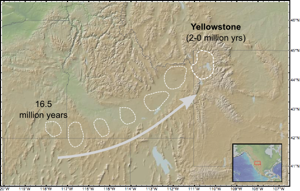
![]() A couple of weeks ago, I showed the trough excavated through the mountains of the western US by explosive caldera eruptions above the migrating Yellowstone hotspot.
A couple of weeks ago, I showed the trough excavated through the mountains of the western US by explosive caldera eruptions above the migrating Yellowstone hotspot.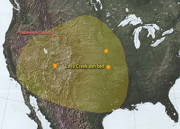



Nice plan for content warnings on Mastodon and the Fediverse. Now you need a Mastodon/Fediverse button on this blog.