What do you mean by “hydrogeomorphic processes”? (Some thoughts following my GSA session on the topic.)

A post by Anne JeffersonGeomorphologists increasingly recognize that the way water is delivered to and moves through a hillslope, river, or landscape affects surficial processes and geomorphic form. Hydrogeologists recognize that geomorphology drives the spatial and temporal distribution of shallow groundwater. But both groups have sometimes seemed to lack the vocabulary and interdisciplinary tools to facilitate making advances truly at the intersection of geomorphology and hydrogeomorphology. The goal of the session I convened yesterday at the Geological Society of America meeting was to highlight studies of hydrologic-geomorphic linkages relevant to a variety of surface processes at timescales ranging from instantaneous (e.g., landslide initiation) to millions of years (e.g., fluvial landscape dissection).

Hydrogeomorphology has been defined as “an interdisciplinary science that focuses on the interaction and linkage of hydrologic processes with landforms or earth materials and the interaction of geomorphic processes with surface and subsurface water in temporal and spatial dimensions (Sidle and Onda, 2004).” The term hydrogeomorphology has not been widely adopted by American geoscientists, although work at the intersection of hydrology and geomorphology is increasingly common and useful for identifying hazards and understanding the impacts of land use and climatic change. Japanese geologists have published a number of outstanding works examining the role of surface and subsurface flow regimes and flowpaths on fluvial erosion and mass wasting, and ecologists have found the concept of hydrogeomorphology useful to describe the linked water and geomorphic conditions that define habitats in wetlands, rivers, and other environments. My co-conveners and I wanted to bring the concept of hydrogeomorphology to the forefront of the American geological community, or at least to fill a day or two with fascinating talks and see who identified their research as fitting within the scope of hydrogeomorphologic processes.

In the paragraphs that follow, I’ve attempted to give you a snapshot of the talks in our session so that you can have a taste of the scope of research that was covered in our session and some of the key themes that emerged in multiple talks.

We started our session on the steep mountainsides of Japan, with an invited talk by Roy Sidle who has worked on landslides and debris flows around the world and collaborated extensively with Japanese researchers who have contributed so much to hydrogeomorphology. Roy did a fantastic job of setting up the idea of connectivity between processes and events, a theme which we heard repeatedly over the afternoon. In Roy’s case, he was looking at whether landslides stopped on the hillslope, reached the channel, or continued downstream as debris flows and whether debris flows occurred during the same hydrologic event that triggered the landslides which supplied the sediment.

Alan Mayo gave us a tour of two intriguing sandstone landscapes where fractures have englarged into ravines deep and wide enough to carry a river, but in which no surface water occurs and whose drainage areas are too small to support one. He previewed the work that he and collaborators are doing to examine the chemical weathering processes (driven by subsurface flow) that may explain these unique landscapes and give us insight into the inception of fracture-controlled river drainages.

Eleanor Griffin of the USGS showed us how the position of an arroyo channel within the valley bottom and the orientation of the thalweg relative to valley gradient (e.g., in meanders) controlled the dynamics of erosion during an extreme flood.

Tom Lisle of the USFS showed lovely field and flume results from a pair of California rivers that have gone through multiple cycles of aggradation and incision. With these rivers he showed us that the relationship between sediment transport capacity and sediment storage was full of hysteresis loops, whose intensity are controlled by channel morphology and armoring.

Mark Lord brought us explicitly back to theme of connectivity by showcasing work in the Great Basin and South Africa and how discontinuities (like wetlands) or artificial connections (like drainage ditches) can alter the hydrology and geomorphology downstream. For example, he showed how the temporal and spatial variability of stream channel connections throughout the watershed affect downstream channel morphology and sediment flux.

Our next invited speaker was Robb Jacobson of the USGS who did a really great job integrating hydrological time series with geomorphic processes and how analysis of those together can be used to determine habitat availability and ecological success. He showed examples from the Missouri River and gravel bed streams in the Ozarks.

After a break, we switched time scales to thinking about the role of hydrology in driving landscape evolution. Our third invited speaker was Jeff Niemann who showed us some really clever results from landscape evolution modeling on how the popular “geomorphically effective event” was no substitute for a whole range of storm sizes, in part because this event was different for hillslopes and river channels. He also showed us how limited storm sizes can drive local incision in otherwise depositional parts of the landscape.

Stephanie Day showed us preliminary results of her master’s research using a laboratory flume to look at the influence of hydrograph shape on the evolution of a channel network subjected to a single base level drop. The natural analogue for her research are tributaries to the Minnesota River basin, in which the mainstem was significantly incised by glacial melt floodwaters from Lake Agassiz, leaving the tributaries hanging.

Miguel Castillo took us to the Scottish Hebrides island of Jura where isostatic rebound since the last glacial maximum has resulted in retreating knickpoints and where he is using cosmogenic isotopes to look at the erosion rates of bedrock rivers above and below the knicks.

Philip Prince told an engaging tale of stream capture on the Blue Ridge plateau – a place not normally thought of as a dynamic, transient landscape – but where stream profiles, the provenance of relict gravels, and fish assemblages suggest that the Roanoke River which drains to the Atlantic Coast has been busy (over millions of years) stealing watershed area from the New River, which drains into the Ohio-Mississippi system.

Robin Mattheus
kept us on the Atlantic coast but told us about three very different modes of formation for estuaries in North Carolina. His question was “How do you get an estuary (drowned river valley), if there’s no watershed area upstream?” It turns out that you can get one by headwater gullying or knickpoint retreat from a confluence during sea level lowstands.

Christopher Esposito kept us on the coast, but brought our time scale back to the short-term present, by chronicling the deposition on a distributary mouth bar on the Mississippi River delta over the course of a single flood in April of this year. In some places he measured more than 3 cm of accumulation from suspended sediment deposition associated with a single event.

Finally, we had the privilige of hosting the award lecture by Vic Baker, the Quaternary Geology and Geomorphology Distinguished Career Award winner for 2010. Vic began his career with the Missoula Floods and has only gone on to bigger and better things since then, shaping the field of paleohydrology and giving rise to the terms “paleofloods” and “megafloods.” Vic truly embodies one aspect of hydrogeomorphology as much of his research has been about the causes and consequences of monster floods that dramatically shape their landscapes. Rather than try to recount the lecture, I think I’ll just repeat one of his many quotable moments of the lecture: “From the flood’s point of view, [it is]…getting a bad rap, because people are doing all the stupid stuff.”

And that, my friends, is the nutshell version of what hydrogeomorphology is all about. Pretty cool, eh?

Categories: by Anne, conferences, geomorphology, hydrology

Stuff we linked to on Twitter last week

A post by Chris RowanA post by Anne Jefferson

DonorsChoose Update – now with a Prize!

It’s been a quiet week for our Earth Science Challenge through DonorsChoose, but as we head into the final stretch of this year’s Science Bloggers for Students event, it’s
time to rally for the cause….and that means it’s time to roll out the prize.

Brian Switek has kindly allowed Anne to donate her review copy of “Written in Stone,” his forthcoming and praise-garnering book on “Evolution, the Fossil Record, and Our Place in Nature.” Look for our review of the book here later this week, as well as an interview with Brian, but let us just say in advance that it is excellent in every respect – lots of cool science and very, very well written. Anyone who donates through our challenge page by November 9th will be automatically entered to win the book, and I’ll notify you by email if you are the winner of the random drawing. So if you’ve been putting off contributing to earth science education, do so no longer. And if you’ve already given, you are already entered, but please give more as you are so moved.

As many geologists gather in Colorado for the Geological Society of America meeting, it seems fitting to highlight the Colorado projects in our challenge. First-graders in Denver need rocks and minerals to touch, sort, classify, and help them get excited about geology. Middle school students in Falcon would love to have a GPS unit to support their school’s geologic mapping project.

Blogs in motion

Volcanoes

Earthquakes

Fossils

Water

Environmental

General Geology

Interesting Miscellaney

Categories: links

Using rock cubes to learn about hydrogeology

A post by Anne JeffersonWhen I teach hydrogeology, one of my labs early in the semester focuses on giving students a hands-on feel for one of the essential hydrogeologic properties of earth materials- porosity.

Porosity is the ratio of voids to solids in the material, and tells us the maximum amount of water a rock or sediment can hold. Porosity is a function of the original grain size and shape (what we call primary porosity), and any cementing, fracturing, or dissolution since emplacement (secondary porosity). Sometimes, not all the void spaces can actually be reached by water, meaning that the effective porosity can be lower than the total porosity. It’s also important to note that porosity can be quite different than permeability, which is the ease with which a fluid moves through a porous material. The next lab the students do focuses on that concept, but first they get to use rock cubes to learn about porosity.

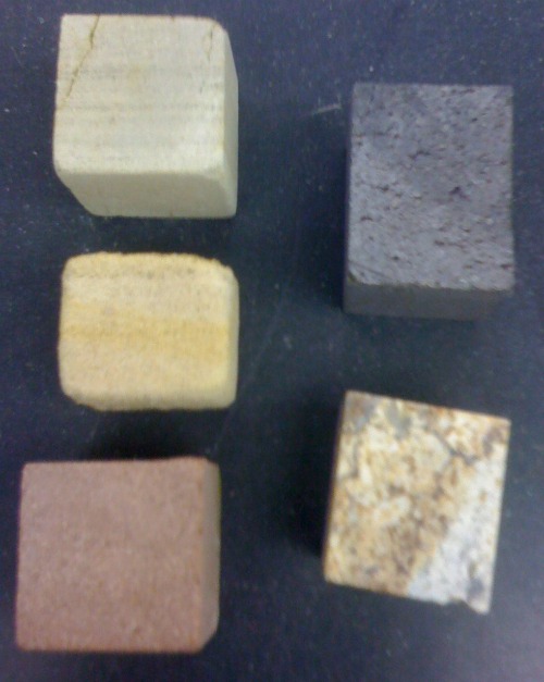
Cubes for measuring porosity

Cubes for measuring porosity. Left column (from top): Eau Claire Formation, Mt. Simon Sandstone, and Chequamegon Sandstone. Right column: basalt and metagranite.

Students are given the five cubes pictured above and asked first to identify their rock types (hope they don’t read the blog!) and they hypothesize about the relative porosity of the samples. Then they measure porosity by two methods: gravimetric (comparing bulk to grain density) and volumetric (submersing the samples in water for 24 hours in a graduated cylinder). I ask them to discuss potential sources of error or uncertainty in their methods and to think about whether they are measuring total or effective porosity. The basalt and metagranite samples are handy for getting them to think about how porosity of a small sample may not be representative of a whole formation. In the North Carolina Piedmont and mountains, rocks like that metagranite are our aquifers, but the flow is entirely through interconnected fracture systems.

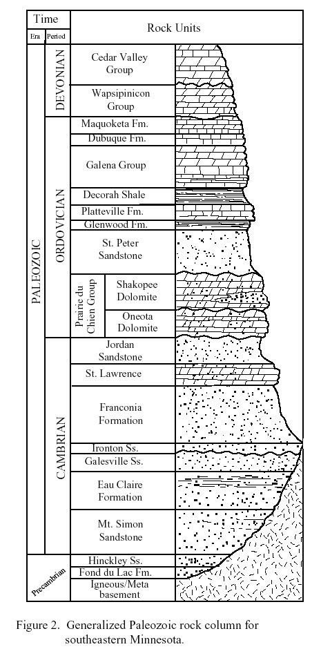
The three sedimentary rocks pictured above are in the lower part of the stratigraphic sequence of southeastern Minnesota, as shown below (source here).

Stratigraphic column of southeastern Minnesota

Stratigraphic column of southeastern Minnesota. The Hinckley Sandstone is equivalent to Wisconsin's Chequamegon Sandstone.

Using some standard relationships, I ask the students to calculate the hydraulic conductivity of the formations and suggest which of them would make good aquifers. One of those rocks is a principal aquifer in much of the northern Midwest. Another is variously considered either an aquifer and a confining layer depending on its local properties. One of my goals for next summer is to collect samples higher in that stratigraphic sequence, in order to get students thinking about porosity and permeability in carbonate rocks.

Want kids get their hands on rocks before they get to college? How about helping Denver first graders get a “rock solid” education? Or New York City 6th graders examine rocks and minerals?

Categories: by Anne, hydrology, rocks & minerals, science education

Stuff we linked to on Twitter last week

A post by Chris RowanA post by Anne Jefferson

DonorsChoose Update

We’re wrapping up another spectacular week for supporting Earth Science in the schools.. The Highly Allochthonous drive has now raised over $1000 from 14 donors and touched the lives of 589 students. Among the projects you helped complete this week were both of the “water warriors” projects I featured on Thursday. If you are looking for another project in need of help, how about giving sets of minerals and rocks to a 6th grade classroom in New York City? Or supporting a classroom that wants to buy some books of beautiful landscape photography by Michael Collier? Huge thanks to all who have given and spread the word.

General Geology

Water

Volcanoes

Earthquakes

Fossils

Planets

(Paleo)climate

Environmental

Interesting Miscellaney

Categories: links

From Weather Detectives to Water Warriors

A post by Anne JeffersonEarlier this week, I was incredibly humbled by the outpouring of geoblogospheric support for a DonorsChoose project to help South Carolina elementary school students become weather detectives. With only minutes to spare before the project lost its chance, with help from 13 donors, the last dollars were raised to get those students a thermometer, wind vane, rain gauge, weather maps, and weather related books and craft supplies that will really enrich their educational experience. The thank-you letter from the teacher brought tears to my eyes. Here it is:

Thank you so much for generous gift. Without your donation, this unit would not be possible. My students will now have a chance to measure with these weather tools just like meteorologist do. The alternative would be to visit local websites and write the temperature, wind speed and direction, and rain fall amounts. Because of your generosity, my students are fortunate to now have a weather vane, anemometer, rain gauge, and thermometer. Now they can measure weather conditions, write the data in a table, and then interpret the data.

The craft materials allow my students to create models of the weather cycle and clouds. They can create booklets on severe weather, clouds, and weather tools, too.

I am also very excited about the new books about weather we will receive. Some of these books are just not available in the library. Now that we have the books for our class, I can read the books to the class, and the students can read them as individuals and take Accelerated Reader tests.

So much good will come from this project. Students will work with every modality, visual, kinesthetic, and auditory.

Again, thank you for your generous gift. Now my students can be true weather detectives!

With gratitude,
Mrs. P.

We did a good thing. Thanks to those who donated and those who spread the word. But there’s so much more to be done.

Weather is just one small part of the Earth system…maybe it’s time to turn our focus to another vital component…water.* There are two fantastic projects in our challenge that only have a few days left to meet their funding goals. Appropriately, one has to do with groundwater and the other has to do with surface water.

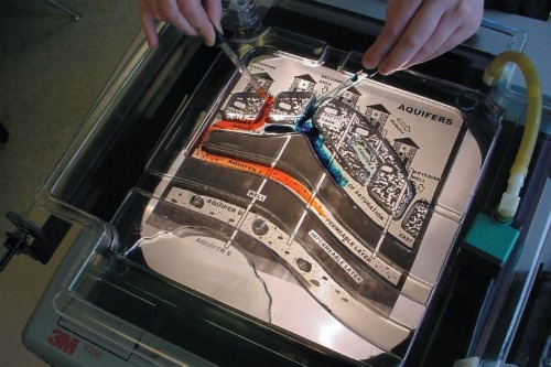
Where does that water go?” needs just $50 to bring a groundwater flow table to students at a magnet school in Charlotte, North Carolina. The model would allow the teacher to “simulate many real-world groundwater concepts involving aquifers, sinkholes, caverns, geysers and hot springs” and offer “hands-on demonstrations allow the user to trace underground water patterns using colored dye.” Here’s what it looks like:

Groundwater flow table from Frey Scientific

Groundwater flow table from Frey Scientific, as requested in the DonorsChoose project Where does that water go?


It’s a pretty cool little model that looks like it will do a great job of helping the students visualize where water goes when it sinks into the ground. Let’s help them get it with just $50 more in donations in the next 10 days. This is definitely a case where every $5 will make a big difference.

The surface water project that I’m championing is called “Clean It Up!” and involves high school students in Chicago. It’s a bit more of a challenge financially – needing $385 of our dollars in the next 10 days. But the note from the teacher is inspirational:

Think about the first time you learned of an issue you care passionately about. Perhaps it was climate change, the achievement gap, poverty, or war. These resources will allow my students to become captivated and inspired by the current situation of water pollution in Chicago. They will bring a real-world issue into the classroom, and allow them to discover a passion for solving the issues of waste-water in Chicago rivers.

Not only will they learn about what should and should not be in our rivers, lakes and ponds, but they will be able to test for it and analyze the political and social motivations that keep our waterways polluted.

Our project will include research on the history and current issues in Chicago, and require students to discover methods for cleaning up Chicago rivers. They will be required to present those findings to our local officials, moving from scientific investigation to civic engagement.

My 5th grade teacher once told me that you only get a few opportunities to become environmentally passionate. I am not simply requesting resources for a unit on water and soil, I am requesting an opportunity to inspire my students. An opportunity to allow them to fulfill their potential of being stewards for the environment.

What a great integrative experience for high school seniors. Let’s help them Clean it Up!

*Don’t worry, rocks are coming. And you all have been doing a great job of funding rock projects without too much need for cheer-leading on my part.

Categories: by Anne, science education