Flooding around the world

Based on information from The Flood Observatory and other news sources, here are some tidbits about on-going and recent flood events around the world. Every one of these floods is having significant local and regional impacts, even if they don’t make the international news circuit. Common threads amongst these floods are the impact of the La Nina climate pattern and the unequal distribution of flood risks across the economic spectrum.

New Zealand

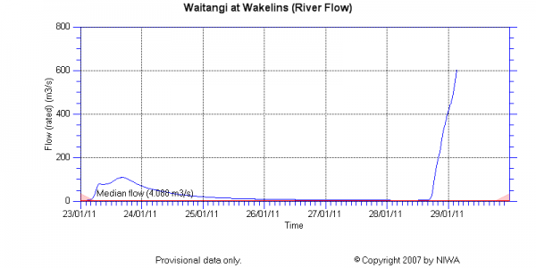
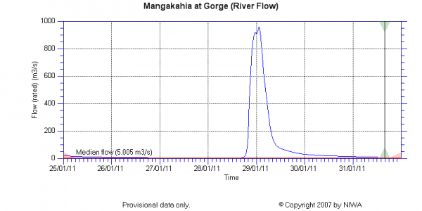
Cyclone Wilma hit the northern end of New Zealand’s North Island on Friday and Saturday 28-29 January, bringing with it intense rains, flooding, and landslides. Wilma unleashed about 28 cm of precipitation in just 12-14 hours, resulting in damage to homes, roads, and water and sewer treatment infrastructure. This was the fourth tropical low to impact New Zealand in just three weeks. The New Zealand Herald has a nice collection of reader-submitted images showing flooding and damage in various areas. My particular favorites are this flooded river valley and this road closed by a landslide. The New Zealand National Institute of Water and Atmospheric Research (NIWA) provides near real-time hydrologic, sea level, and climatic data through their Environmental Data Explorer, so I can show you quantitatively what this cyclone meant for a couple of rivers.

Mangakahi River at Gorge stream discharge data from NIWA

Mangakahi River at Gorge stream discharge data from NIWA

Waitangi River at Wakelins stream discharge data from NIWA

Waitangi River at Wakelins stream discharge data from NIWA

While the graphs above show discharge (flow volume per time), which is the unit of currency for hydrologists who want to compare multiple rivers to each other, local flooding impacts depend also on the depth(or stage) of the water. For reference, the Waitangi River goes from ~0.4 m before the storm to 6.2 m at the end of the record shown above. If you click through to this image on the New Zealand Herald website, you’ll see why the record for the Waitangi River ends when it does. That gaging station wasn’t meant for those flow conditions.

Australia

While Queensland begins to tally its losses and recover from massive flooding earlier this month, tropical cyclones aren’t about to make the job any easier. Cyclone Anthony brought mostly heavy winds to the Queensland coast south of Townsville Sunday night, and damage is reported to be minimal. But much bigger and much stronger Cyclone Yasi is expected to make landfall in the same area as a Category 4 storm later this week. This cyclone is expected to produce widespread, heavy rain, a strong storm surge along the coast, and winds up to 260 km per hour.

Meanwhile, in the southeastern state of Victoria, tributaries to the Murray River are also flooding. These floodwaters are still rising and are expected to take weeks to months to recede. Increasing my sympathy for the Australians, Victoria and South Australia are also experiencing a ridiculous heat wave, with temperatures reaching or exceeding 40 C for several days in a row.

Saudia Arabia

Flooding occurred around the city of Jeddah over the weekend, killing at least 10 people. Three hours of rain produced 11 cm of precipitation, cars were washed away, and the video below shows the failure of a dam, which the videographer says contained a lake used for dumping untreated sewage.

South Africa

Flooding in South Africa has gotten almost no international attention, despite the fact that floods have killed 120 people there and have caused disaster declarations in 8 of 9 provinces. Flooding has also affected Mozambique, where 13 people have died, and forecasts for continued heavy rains over the next several months have much of the southern part of the continent on alert. In some areas, up to 10 times as much rain as normal has fallen in the month of January. Tens of thousands of homes have been destroyed. Many of the lost homes are shacks belonging to poor Africans, because informal settlements are often located in low lying areas.

Brazil

The clouds have cleared over the area around Rio that was hard-hit by floods and landsliding earlier this month. The death toll now exceeds 840 people, and the Brazilian federal and state governments have promised to provide up to 8000 homes for people that lost theirs in the disaster. The government also plans to immediately begin increasing its disaster preparedness, including mapping of high risk areas and better weather data collection. Dave Petley did a great analysis using before and after aerial imagery in one of the slide-affected area.

Categories: by Anne, geohazards, geomorphology, hydrology

Stuff we linked to on Twitter last week

A post by Chris RowanA post by Anne Jefferson

Blogs in motion

The Scienceseeker Geosciences category is now nicely populated with many more geoblogs, but it turns out the list I submitted is already out of date, as a couple more blogs have already popped into existence:

Volcanoes

Earthquakes

Landslides

Fossils

(Paleo)climate

Water

Environmental

Planets

General Geology

Interesting Miscellaney

Categories: links

New at Erratics: Bubbling up

Your friendly Highly Allochthonous bloggers have already treated you to unconformicakes and edible debris flows today; now, if you head over to Earth Science Erratics, new contributors Kathy Cashman and Alison Rust present a fascinating discussion of the role of gas bubbles in volcanism and…bread!

Understanding bubble formation and migration is particularly critical for understanding volcano behavior, where gas expansion provides the primary driving force for volcanic eruptions. However, bubble behavior also affects magma chamber processes and ore deposit formation. The physical properties of bubbles that make them such effective drivers of magma motion are their buoyancy, their volume sensitivity to pressure and temperature, and their deformability, properties that are easily explored in the kitchen. Here we start our exploration of cooking analogies with bread, where the revival of artisan breads provides a wide array of bread textures and techniques.

Go and read, and if you’re anything like me, you’ll learn as much about the science of breadmaking as you do about volcanic bombs.

Categories: links, volcanoes

Edible debris flow

Steep hillslopes with loose sediment are at risk from debris flows triggered by heavy rain or rapid snowmelt. As water is added to the hillslope, surface runoff or positive pore water pressure catastrophically destabilizes a portion of the slope. Pulled by gravity, the water and sediment mixture moves downslope – picking up trees, boulders, gravel, and more mud and water along the way. Usually nothing stops these flowing masses of debris until they reach a relatively flat surface.

Debris flows have the power to reshape mountainsides and valley bottoms, and they can cause tragic devastation to people and property in their way. From North Carolina and California to Japan and Brazil, debris flows are a significant natural hazard and an area of active research by geoscientists and engineers.

In the spirit of the Accretionary Wedge, I decided to undertake my own research and investigate the possibilities for an edible analog for debris flows. First, I assembled sediments of a range of sizes, shapes, and natural cohesions.

Ingredients of my debris flow pilaf

Loose sediments (clockwise from top right) of the onion, rice, lentil, potato, portabella, garlic, pepper, salt, coriander, ginger, and barley varieties.

Then I added water to saturate the mixture, and placed it on a slope. Voila, debris flow pilaf! From the view below, you can see a bunch of features of debris flows.

Debris flow pilaf

Debris flow pilaf

  • At the top, there is the area of initial failure. In this case, it appears to be in the midst of a broccoli clear cut, where root strength had been weakened, reducing cohesion in the soils.
  • The debris flow then moved downslope in a somewhat confined manner. Usually the flow will move down an existing channel on the slope, but sometimes debris flows have to start from scratch and may not leave much of an erosional impression.
  • There is some evidence that the debris flow bulked up by lateral accumulation of material on its downslope track (i.e., places where sediment appears to accrete along the sides of the flow).
  • At least one large boulder has been rafted along the top of the flow, thanks to the quirks of fluid mechanics in very viscous fluids.
  • When the flow moved off the hillslope and onto the valley floor, the potential energy disappeared and the flow quickly stopped moving. Sometimes, debris flows will form a fan shape deposit at their front. But in our case, while there was some lateral spreading, it just stopped moving a short distance out onto the flat.
  • At the flow front, there is a significant accumulation of woody debris. (Amazing that it has kept its leaves on!) This debris has either been rafted on the top of the flow or been pushed along ahead of it.
  • There is a higher concentration of the coarsest grain sizes at the flow front. This sort of bouldery front is typical of debris flows where coarse material is available. You can see this better in the image below.
Overhead view of the debris flow runout.

Overhead view of the debris flow runout.

Of course, there are some limitations to using kitchen ingredients as analogs for debris flows. I highly encourage you to watch this classic USGS video on debris flows for its incredible footage of a whole range of debris flow materials and behaviors, all set to the most wonderful classical music. (Seriously, try the first 40 seconds of part 1 and see if you are not hooked.) Then, after you’ve watched the videos, I encourage you to use the comment section to make suggestions for improvements to the physical realism of future experiments with edible debris flows.


If that’s not enough debris flow video goodness to satisfy your appetite, check out these USGS videos of debris flows at their experimental flume in the Oregon Cascades. The recipe for barley pilaf with lentil confetti (or as it shall always be known in my mind: “debris flow pilaf”) came from Didi Evans’ Vegetarian Planet.

Categories: by Anne, geohazards, geomorphology

The baking of an angular unconformity: Hutton’s Unconformicake

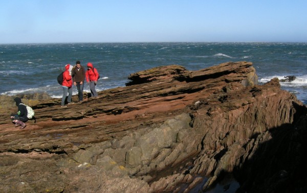
A post by Chris RowanHopefully, now that you’ve gotten a good look at the real Hutton’s Unconformity in all its geological splendour, you won’t think too badly of my attempt to recreate it in cake form for the Accretionary Wedge Bake Sale.

Angular Unconformity at Siccar Point

Hutton's Unconformity

Hutton's Unconformicake.

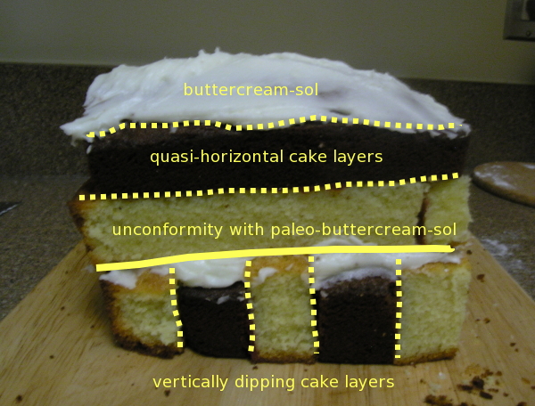
Some annotations show that the “Unconformicake” recreates at least the basic features of the outcrop at Siccar Point, even if I’ve yet to find a rock that weathers to buttercream.

The annotated unconformicake

The annotated unconformicake

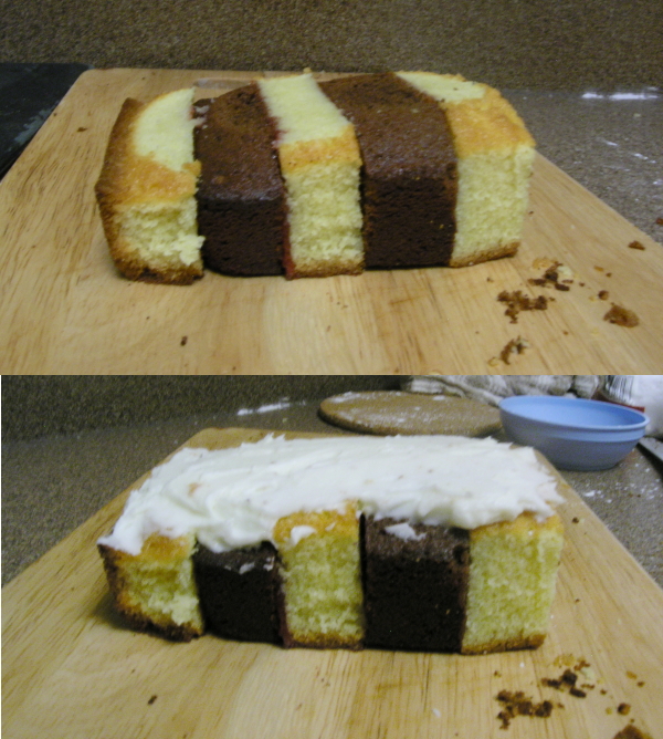
However, one of the reasons that I chose to make this particular cake was that the process of making it mirrors the events that produced the outcrop at Siccar Point. For reference, my raw materials were two loaf cakes, one vanilla, one chocolate. First, I stacked alternating vertical slices of vanilla and chocolate cake on top of each other, using liberal quantities of raspberry jam as a lithifying agent.

Banded chocolate and vanilla cake layers being deposited in an initially horizontal orientation

I then rotated this stack onto its side, and used a knife to level off the top – creating lots of clastic crumbs in the process – before covering it with buttercream icing.

The lower banded cake unit is tilted and eroded.

Next, horizontal slices through the vanilla and chocolate loaves were laid down above the buttercream layer.

The upper banded cake unit is laid down.

More buttercream was added to finish, to represent a modern erosion surface.

The finished unconformicake.

Of course, since culinary erosion rates are much higher than geological ones, it did not take long for this outcrop to be significantly cut down to size, it’s profound structural and temporal secrets lost to would-be Huttons of the cake-baking world.

Rapid erosion of the unconformicake in the 4 days after baking.

Those of you who are good with geometry may have worked out that I didn’t quite use all of my two starting loaves to create the unconformicake: in fact, enough remained to create a bonus allochthonous thrust sheet. Appropriately, chocolate was acting as the exotic terrane.

Should this be our new banner, do you think?

Unsurprisingly for a recreation of a structure produced in zones of significant mountain-building, uplift and erosion, this particular specimen was reduced to nothing in no time at all – although oddly enough, just as with the unconformicake the major forces at work were anthropogenic weathering agents. Maybe there’s a Nature publication in this…

Categories: bloggery, structures