![]()
![]() As you probably know. I’m interested in tectonics: how the relatively rigid top 100 km or so of the Earth deforms over time. I also study paleomagnetism, or the record of the Earth’s magnetic field. This field, generated by convection in the outer core 3000 km below our feet, is imprinted on rocks as they form, and allows us to reconstruct the drift of the continents over time. Given these interests, I’m hardly going to let a paper entitled ‘Plate tectonics may control geomagnetic reversal frequency’ just slide past, am I?
As you probably know. I’m interested in tectonics: how the relatively rigid top 100 km or so of the Earth deforms over time. I also study paleomagnetism, or the record of the Earth’s magnetic field. This field, generated by convection in the outer core 3000 km below our feet, is imprinted on rocks as they form, and allows us to reconstruct the drift of the continents over time. Given these interests, I’m hardly going to let a paper entitled ‘Plate tectonics may control geomagnetic reversal frequency’ just slide past, am I?
Francois Pétrélis and his co-authors are attempting to solve a puzzle about the behaviour Earth’s magnetic field over geological time. From what we understand about how the geomagnetic field is generated, we would not expect reversals of the field to be amazingly regular; but even taking this expected randomness into account, we can see surprisingly large changes in the frequency of reversals in the geological record. In the last 10 million years, the geomagnetic field has flipped more than 40 times, about once every quarter of a million years on average. In huge contrast, in the Late Cretaceous, between about 120 and 80 million years ago, the field did not reverse a single time. It spent 40 million years stuck in the same polarity, when based on more recent records we would have expected it to reverse more than a hundred times.

The Geomagnetic polarity timescale. Black bars are 'normal' (like modern day) polarity periods, white bars are reversed periods.
The mystery of the ‘Cretaceous Normal Superchron’ lies in the fact that in geological terms, convection in the outer core is extremely rapid. Internally-driven variations in the pattern of convection might cause changes in the behaviour of the magnetic field over tens or hundreds of thousands of years, but it is difficult to explain changes over tens or hundreds of million years in the same way. It seems that something external, something more sedate, must be influencing the outer core.
Pétrélis et al. argue that the primary control over reversal frequency is how evenly distributed the flow of heat out of the core and into the mantle is. If the heat flow is roughly the same everywhere, then the primary control on the shape of convection in the outer core, and hence the shape of the geomagnetic field, is the Earth’s rotation; this will tend to produce a strong dipole. But if the heat flow is uneven – if it is leaving the core faster in some places than in others – then then the large-scale convective flow in the outer core will be disrupted, weaken the dipole, and increase the likelihood of reversals. The most important factor seems to be latitudinal asymmetry in the heat flow: if the amount of heat escaping the core in the northern hemisphere is too different from the heat going into the mantle in the southern hemisphere, then the dipole field is particularly prone to becoming unstable.
This is where plate tectonics comes in – and more particularly, subduction zones, which in the right circumstances can move material from the surface all the way to the lower reaches of the mantle. This material includes things like ecologite – highly altered oceanic crust – that are very different in composition and physical properties to the lower mantle. If this deeply subducted material accumulates unevenly at the core-mantle boundary, then it could disrupt the heat flow across it and reduce the stability of the magnetic field.
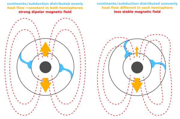
How the distribution of subducted slabs (blue) in the mantle might affect heat flow across the core-mantle boundary (yellow arrows), which might in turn affect the stability of the Earth's magnetic field. Click to enlarge.
The authors propose that because subduction zones usually occur around the edges of continents, if the continents are asymmetrically distributed, then the subduction zones will be too, and so might any subducted slabs piling up at the core-mantle boundary. Using paleographic reconstructions, they have calculated how the latitudinal distribution of the continents on the Earth’s surface has changed over time. If a large proportion of the continental crust finds itself in one hemisphere, this asymmetry factor is high: if it is more evenly distributed, it is low. The figure below, from their paper, plots the variation in this asymmetry parameter over the last few hundred million years in blue, together with the rate of geomagnetic reversals in black.
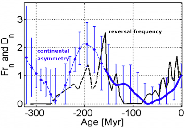
A comparison of reversal frequency over geologic time, with the degree of asymmetry of the continents, as calculated by Petrelis <i>et al.</i>. Click to enlarge.
In the very broadest sense, there are the hints of a correlation here: periods with higher rates of magnetic reversals seem to also be periods when the continents are unevenly distributed, and the Cretaceous normal superchron seems to be a period of more even continental distribution. But as far as I can see, the correlation between continental distribution and reversal frequency really isn’t what you’d expect if this mechanism was in effect. It would take time – 10s of millions of years -for what was happening on the surface to propogate 3000 km downwards to the core-mantle boundary. Which means that you would expect a lag between what the plates are doing, and what the magnetic field is doing: first the continents become unevenly distributed, then the reversal frequency goes up; first the continents balance out around the equator, then you get a superchron. It’s true that when continental asymmetry peaks about 200 million years ago, the reversal frequency peaks around 30 million years later. But the behaviour in both the Cretaceous Normal Superchron, and an earlier Superchron that occurred between 310 and 260 million years ago, is the opposite of what we’d expect: in both cases, continental distribution appears quite asymmetric at the start of the superchron, decreases during it and then only starts to increase after the superchron ends and reversal frequency is already picking up.
So, the lag is inconsistent, and often the opposite of what we’d expect if plate tectonics were indeed reaching down into the planet and affecting processes in the core. One problem might be that looking at the distribution of continentals might not be a very good way of determining the distribution of what we’re actually interested in – the subduction zones. If we compare paleogeographic reconstructions for the Late Cretaceous to today, the loss of the subduction zones in the equatorial Tethys Ocean (now squashed up between India and Tibet) stands out far more than changes in the latitudinal distribution of the continents in general.
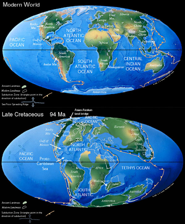
The modern distribution of continents compared to the paleogeography of the Late Cretaceous. Source: the PALEOMAP project
Perhaps, then, the somewhat fuzzy relationship might be firmed up with a better proxy. Until then, I remain intrigued, but unconvinced.
Pétrélis, F., Besse, J., & Valet, J. (2011). Plate tectonics may control geomagnetic reversal frequency Geophysical Research Letters, 38 (19) DOI: 10.1029/2011GL048784



Nice plan for content warnings on Mastodon and the Fediverse. Now you need a Mastodon/Fediverse button on this blog.