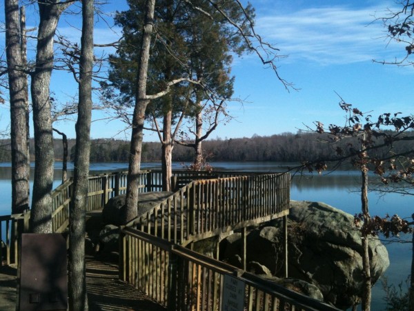
Scenic Saturday: The Temple

A post by Anne JeffersonRight now I have a graduate student working on a project to understand the effects of stream restoration in altering patterns of groundwater-stream exchange. She’s working in four stream reaches with varying restoration patterns and watershed land uses. In one of her streams, there is a restoration structure she calls “the temple.” I’d walked the lower bit of stream and the upper bit of stream, but somehow I’d managed to miss this feature that is having remarkable effects on the transient storage dynamics of the stream. This week, I rectified my omission and visited the temple.
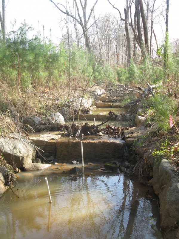
Stream restoration in BD3

The stream restoration feature known as "the temple". The white pipes are our piezometers for measuring exchange between stream and subsurface water. Photo by A. Jefferson, March 2012.

What the photo above doesn’t fully capture is how large a volume of water is stored behind each of the rock step structures. This picture was taken as water was receding after a pretty high flow event (notice all the debris trapped at the top of one step), but at lower flows there is little or no water going over the top of the steps. Instead, all of the water goes under or around the rock structures and pools of water more than 1 m deep occur between each of the structures. Such big pools at such low flow volumes could have a dramatic effect on things like stream temperature and nutrient dynamics.

This structure is all the more remarkable because it occurs at an interesting geomorphic transition in the stream. Upstream of the temple, the stream is restored using typical features like cross-vanes and riffle/pool features. It is low gradient and not confined in a valley.
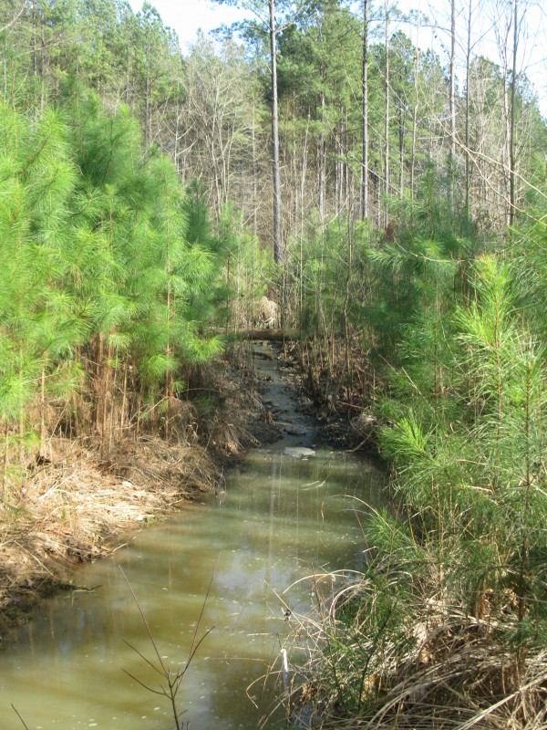
A large pool and riffle

Upstream of the temple, restoration structures include a riffle (in the background) and cross vanes (foreground, here submerged by high water). Photo by A. Jefferson, March 2012.

Immediately downstream of the temple, there is a big pool and then a long reach floored with bedrock (obviously not restored). Downstream of the bedrock reach, the stream crosses into the floodplain of a larger watershed and has lots of fine grained alluvium to contend with.

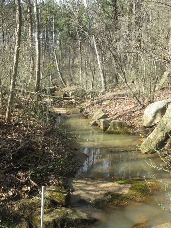
Stream with pools and exposed bedrock in a forest

Downstream of the temple, the bedrock-rich stream reach. Photo by A Jefferson, March 2012.

Thus, it appears that “the temple” restoration feature is placed at an important geomorphic transition in this stream. It’s in the place where the stream briefly enters a more confined valley and it’s the steepest part of the stream. In other Piedmont streams, I’ve seen bedrock cascades in some places like this, but the stream restoration designers wouldn’t have covered over a feature like that. Instead, maybe there was a knickpoint retreating through soil, saprolite or colluvium that could cause a lot of potential instability in the reach above. The “temple” feature then would be a way of preventing further knickpoint retreat by creating a short high-gradient section. I really wish I’d seen this area before the stream was restored. Instead, I marvel at the highly engineered form of the stream as it passes through the temple, and look forward to seeing what my grad student finds out about the effects of this structure on the transient storage and water quality in the stream.

Categories: by Anne, fieldwork, geomorphology, hydrology, photos

Now that’s what I call a geomagnetic storm!

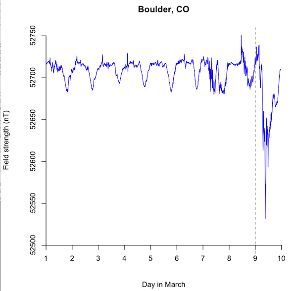
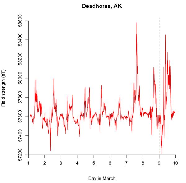
A post by Chris RowanIt appears that I was a litte premature with yesterday’s post. Look at what happened to the ambient magnetic field at the two observatories at Boulder and Deadhorse today (the dotted line represents about where the plots I put up yesterday ended):

Magnetic field strength variations at Boulder, CO, 1-9th March

Data from the USGS

Magnetic field strength at Deadhorse, AK, 1st-9th March

Data from USGS

This latest fluctuation is especially prominent in the data from Boulder, although this is because the background variability is so much smaller here – the actual change in the field (150-200 nT) is actually smaller than the change observed at Deadhorse (approximately 1000 nT). Nonetheless, the fact that this fluctuation is so prominent so far from the pole shows that the magnetosphere is getting a bit of a battering.

So what’s changed? According to NASA:

As of March 8, the storm was fairly mild since the magnetic fields from the CMEs were partially aligned with Earth’s own and thus slid around the magnetosphere. However, the geomagnetic storm has increased because the magnetic fields of the CMEs have now changed direction such that they can more easily deposit magnetic energy and radiation into Earth’s environment.

So it seems the magnetic field of the coronal mass ejection was originally aligned so that the Earth’s magnetic field mostly pushed it away, in the same way that the north (or south) poles of two bar magnets repel each other if you try to put them together. But now the field has changed its alignment, making it more like what happens when you put the opposite poles of two bar magnets close to each other: they don’t take much encouragement to bang together. Still, it seems that the real-world effects are limited for now – unless you’re a field geophysicist planning to do some magnetic surveying. Rapid changes in the background field like this will drown out any changes due to changes in the subsurface, so they’ll be a few days of waiting for things to die down before any useful measurements can be made.

Categories: geohazards, geophysics, palaeomagic, planets

The Earth weathers another geomagnetic storm

A post by Chris RowanA couple of days ago, the sun got a bit excitable:

This large flare produced what is known as a Coronal Mass Ejection (CME), a blob of gas and radiation hurled at high velocities from the surface of the sun out into space, and which forecasts last night suggested was heading our way. This was potentially worrying, because when material from a CME impacts with the Earth’s magnetosphere it can cause a geomagnetic storm – powerful fluctuations in the local magnetic field that can not only damage orbiting satellites, but potentially induce crippling voltage fluctuations in our power grids.

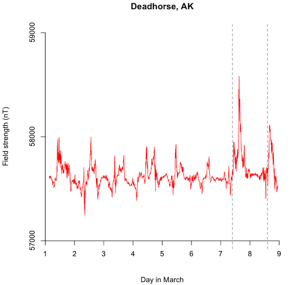
The CME was forecast to pass through our planetary neighbourhood early this morning, so I was happy to wake to working electricity and internet. Still, I was curious about what effect the CME was having on the Earth’s magnetosphere, so I looked up some measurements from a couple of the USGS’s magnetic observatories. The figure below shows how the magnetic field strength in Deadhorse, Alaska – within the Arctic Circle – has varied since the beginning of March.

Geomagnetic field strength measured in Deadhorse, Alaska, in the first week of March. Data from the USGS.

Most of the magnetic field measured in Deadhorse or anywhere else on the Earth’s surface is being generated by convection in the Earth’s outer core. But this internal field will not vary too much over periods of days and weeks, so the fluctuations that we’re seeing on this plot must have an external cause. Mostly, they’re due to interactions of the magnetosphere – the part of the Earth’s magnetic field that extends beyond the atmosphere – with the solar wind. Bigger fluctuations correspond to a stronger, more energetic solar wind. The field before the 6th March appears has its fair share of jerks and fluctuations; Deadhorse is at a high latitude close to the north magnetic pole, where field lines run straight down from the magnetosphere into the inner core, so the solar wind has an especially strong influence here. However, there are two especially large jumps in the field on Wednesday and Thursday, marked roughly by the dotted vertical lines, which might be to the CME.

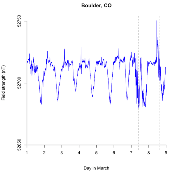
I also looked at data from the geomagnetic observatory in Boulder, Colorado.

Geomagnetic field strength measured in Boulder, Colorado, in the first week of March. Data from the USGS

We’re further from the pole, so the overall field in Boulder is a bit weaker. The external contribution to the ambient magnetic field still varies over the whole period I downloaded data for, but these fluctuations are both smaller than those observed at Deadhorse (20 or 30 nanoTeslas as opposed to more than 500 nT) and also more regular; there’s a definite day-night cycle caused by the the Earth’s rotation. This regular cycle is clearly interrupted on the 7th and 8th (yesterday and today), and the dotted lines show that these fluctuations at Boulder occurred at pretty much the same time as the largest jerks at Deadhorse do. This synchronous timing, seen in two places thousands of miles apart, tells us that this is a large-scale fluctuation of the magnetosphere, caused by it interacting with a large packet of unusually energetic solar wind.

So this latest CME did not pass our orbit completely quietly, even if it didn’t melt our power lines as it sped past. We can breathe a sigh of relief, and use our still functioning internets to go ‘ooh’ at the supercharged aurora.

Categories: geophysics, palaeomagic, planets

Scenic Saturday: a special place

A post by Chris RowanA purely scenic one this week, but this is a place that is very special to both Anne and myself.

Buzzard Rock

Buzzard Rock, Latta Plantation, North Carolina. Photo: Chris Rowan 2012.

It’s not surprising that we can both find things to appreciate about this overlook: after all, as the cliche goes, I like rocks and Anne likes water. But here, as is often the case – as is the case on this blog, in fact – it is the combination of the two that has the most pleasing results.

Categories: photos

New at Erratics: the challenges of teaching geology in high school

Our newest Earth Science Erratics blogger, Erin Parker, is a teacher at an urban public high school in Wisconsin, who every semester is presented with the task of teaching “150 boisterous students” about earth science. In her first post, she describes an exercise aimed at teaching them about the sequence and tempo of geological history:

Today, I’ve handed out props with rough dates attached, and asked the class to physically arrange themselves in order of appearance in the fossil record- a stuffed black plague microbe stands in for the first life-forms; a plastic Buzz Lightyear represents modern humans…

Head over to find out how they do, and read Erin’s thoughts on the particular challenges of making geology interesting and relevant to students who may only be taking it as a science credit of last resort; something that is going to be a major theme of her posting.

I don’t know the answers, but I am certainly trying to make geology and oceanography come alive for my kids. My contributions to Earth Science Erratics will focus on my challenges and successes connecting students to earth science, and my own occasional sojourns into the realm of field geology.

School is where the vast majority of people get most of all the science education we’re ever going to get, but with the occasional awesome exception, blogging about teaching at this level is far less common than blogging about teaching at Universities. So we’re delighted to welcome Erin to Erratics, and the geoblogosphere, where we can all hear about, and learn from, her experiences. Please go and say hello!

Categories: links, teaching