Stuff we linked to on Twitter last week

A post by Chris RowanA post by Anne Jefferson

Volcanoes

Earthquakes

Planets

Fossils

(Paleo)climate

Water

Environmental

General Geology

Interesting Miscellaney

Categories: links

Scenic Saturday: White Island before the spiny lava invasion

A post by Chris RowanLast week, Erik drew my attention to this odd spiny lava dome spotted on New Zealand’s White Island. It is rather strikingly weird, like the country that brought us the Lord of the Rings had decided to now bring us The Thing – Volcano Edition.
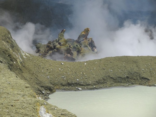
Lava dome on White Island

Shapeshifting alien invader, or very viscous lava dome? You decide. Source: GNS

What makes this especially interesting for me is that I’ve visited White Island: during my PhD, I spent several months doing field work on the North Island, and on one of my days off in 2003 I drove up to Whakatane* in the Bay of Plenty and took one of the boat tours out to the island.
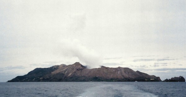
White Island, New Zealand

A boat’s-eye view of White Island, a volcanic island in the Bay of Plenty, northern North Island, New Zealand. Photo: Chris Rowan, 2003.

Given this is an active volcanic island, you might expect actually landing on it to be a rather intrepid affair. However, things are made considerably easier by the fact that one side of the caldera has been breached (either inward by the sea, or outward by an eruption; I don’t actually know).
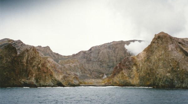
White Island, New Zealand, caldera wall breach

A breach in the caldera wall that allows intrepid tourists access to the inside of White Island. Photo: Chris Rowan, 2003.

Once inside, you are treated to a barren landscape of greys, dusky reds and sulphurous yellows. When we were there, the most active part of the caldera was at the far end from where we landed, where a large, continuous plume of steam was rising from a crater lake. From the wider shot included with Geonet’s bulletin about the lava dome, it looks like this is still the most active area, although it seems to have grown slightly from when I was there.
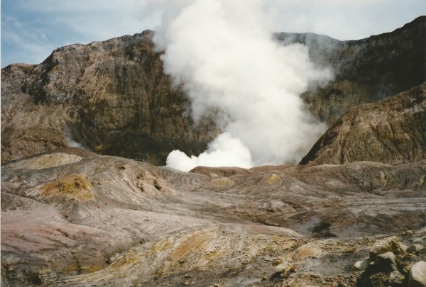
Inner Caldera, White Island, New Zealand

The most active part of White Island’s caldera on my 2003 visit. The steam is coming from a crater lake. Photo: Chris Rowan, 2003.

We were able to get close enough to peek at the lake. At the time, our guides said we were quite lucky to see the level of activity we did, with a lot of bubbling, and churning, and muddy water being hurled tens of feet into the air. This would probably be considered a quiet day nowadays.
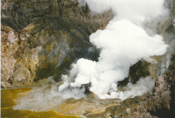
Crater lake, White Island, New Zealand.

Mud bubbling and boiling in White Island’s crater lake. Photo: Chris Rowan, 2003.

A closer look at the caldera floor allows a small glimpse into the history of White Island: there are clearly differentiated layers of volcanic ash that represent different eruptions (or pulses of the same eruption). They are also some much coarser layers which were probably deposited by pyroclastic debris flows.
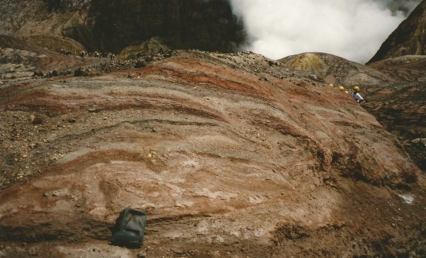
Ash and pyroclastic flows, White Island, New Zealand.

Some White Island stratigraphy: fine ash and coarser debris flows. Photo: Chris Rowan, 2003.

The caldera floor is also dotted with fumaroles emitting volcanic gases. They are easily spotted by the deposits of vivid yellow sulphur precipitated around them.
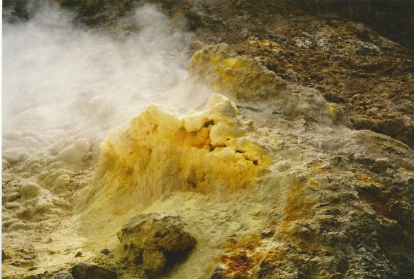
Volcanic sulphur deposits, White Island, New Zealand.

Yellow sulphur deposited around a fumarole (gas vent) in the caldera. Photo: Chris Rowan, 2003.

There were various attempts to mine this sulphur in the 19th and early 20th centuries. Needless to say, this was a dangerous job: in 1914, ten men operating the latest mining operation were killed when their encampment was engulfed by a lahar that accompanied an eruption. The remains of the last sulphur processing plant are close to where the boat tours land: it’s quite an eerie juxtaposition to see the tour parties poking around a place occupied by people who probably would have thought that anyone visiting this place for pleasure was mad.
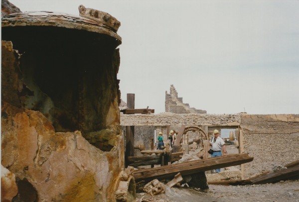
Mine Ruins, White Island, New Zealand

The corroded, skeletal remains of the sulphur mine that operated in the late 19th and early 20th centuries. Photo: Chris Rowan, 2003.

As I stared out of the volcanic caldera of an active, explosive subduction zone volcano into the ocean beyond, I couldn’t help but feel that perhaps they wouldn’t be entirely wrong. Not that I regret going at all, but it was one of those times when perhaps even I, with more grasp than most of the nature of the risk at places like this than many visitors probably do, let my desire to see for myself over-ride my common sense.
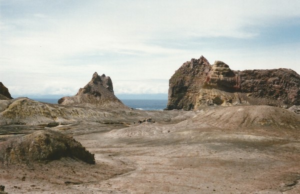
White Island caldera, New Zealand

Looking out to sea from inside the caldera. Photo: Chris Rowan, 2003.

* a name made even more awesome when you remember that in Maori, ‘wh’ makes an ‘f’ sound.

Categories: geohazards, photos, volcanoes

Earthly and Unearthly Beauty

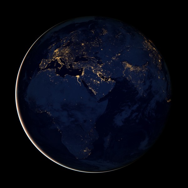
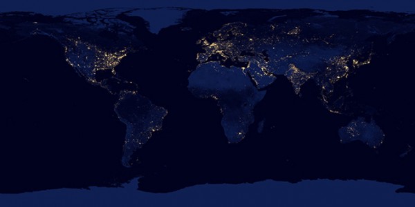
A post by Chris RowanNASA unveiled a couple of rather beautiful things at AGU last week – and despite actually being at the conference, I haven’t really had the time to sit back and appreciate them until now. The first was the ‘Black Marble’, a composite image of the Earth at night courtesy of Suomi satellite that is both starkly beautiful, and sobering.

Black Marble: Africa and Europe at night, as viewed by NASA’s Suomi Satellite. Source: NASA Earth Observatory.

The name is presumably intended to place this new image as a counterpoint to the Blue Marble, and it is, on a number of levels beyond the obvious night/day distinction. The original Blue Marble, with its subsidiary greens and browns, has always been held up as an exemplar of the beauty of our life-bearing planetary ark, sailing through the black vastness of space. The Black Marble, dominated as it is by the lights of our cities and roads, provides stark visual proof of how our species is driving a grand alteration of our ‘pale blue dot’. Carbon dioxide might be invisible, but street lights are not.

Black Marble: the whole Earth view. Source: NASA.

Sadly, whilst the multiplying and increasingly serious consequences of our grand experiment in inadvertent geo-engineering experiment were also spelled out in San Francisco last week, politicians in Doha who managed but a few faltering steps towards actually addressing the looming climate crisis. It’s pretty astounding to think that when it comes to climate change, the political process is actually moving more slowly than some geological ones.

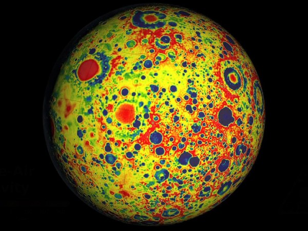
Moving to impacts of a different kind, the other images that made me go ‘ooh’ when I saw them last week were the lunar gravity maps generated by the GRAIL satellites. The initial product is rather handsome, with most craters still appearing as negative gravity bullseyes, indicating excavated or vaporised crust

The Moon as seen by the GRAIL gravity satellites. Source: NASA.

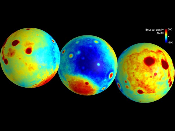
But I think that the Bouger gravity maps – which, more or less, filter out the effect of the surface variations in mass caused by topography to reveal subsurface structure – are even better. Especially since that these data are in many ways transforming our understanding of the structure and geological history of the Moon, and at worst giving us the story in far more detail than we’ve ever had before. Impacts that blew a hole through the entire lunar crust! Most of the crust is formed of low density impact breccia! Giant, super-ancient dykes formed by expansion!

If you want the full story on the GRAIL data, you should sit down to read this truly wonderful explainer by Emily Lakdawalla. Fabulous imagery and cool science – what more could you ask for?

Categories: climate science, geology, geophysics, photos, planets

AGU Dispatches: Final Day and Final Thoughts

A post by Chris RowanUnless you are presenting, the final day of a 5 day-conference can be a test of your intellectual fortitude: it can be tough to force your tired and stuffed-with-cool-new-science brain to take an interest in any more talks or posters. Still, it behooves us all to try, if only because you never know when it might be you who is giving one of the presentations in the Friday afternoon slot (as yours truly did last year), so the Golden Rule applies.

And thus it was that not too long after the 8am start, your intrepid blogger was installed in a session on continental rifting, with a focus on the Midcontinental Rift, a 1.1 billion year-old lava-filled hole in the ground which appropriately, if rather generically, dominates the geology (and gravity signature) of the US Midwest. It’s such a huge amount of lava, that it’s hard to understand why it ‘failed’ (in the sense that it didn’t transition to full oceanic spreading). But it does drive home the fact that the contribution of rifting processes to the growth of continental crust is somewhat under-appreciated, as Margaret Benoit rather astutely pointed out in the session. Her talk – which demonstrated how large amounts of basalt added to the continental crust in the Neoproterozoic was a major influence on the shape of the Appalachian mountain belt hundreds of millions of years later – was extremely interesting, as was Nick Swanson-Hyell’s contribution, which was an update of his paleomagnetic analysis of the lavas where they are exposed around Lake Superior, which I’ve written about before. It still seems that during eruption of the rift basalts Laurentia was moving rather faster than anyone is comfortable with, which also probably rules out the idea that the rift magmatism was fuelled by a mantle plume.

I then nipped across the way to a more seismology-focused session, where Nicholas van der Elst was the latest person to grapple with the question of whether great earthquakes can trigger other great earthquakes elsewhere in the world. As he pointed out, the recent cluster of extremely damaging earthquakes starting in 2004 is of more than academic interest: most of the people who have died due to earthquakes in living memory have died in the last seven years. Van der Elst’s analysis suggests that despite the recent carnage, there is no evidence for the earlier quakes such as the 2004 Sumatra quake triggering later ones, such as last year’s Tohuku quake (take that, Simon Winchester), although it should be noted that he was only examining one possible triggering mechanism, where the earlier great earthquake induced an increase in the rate of background seismicity in the area around the later great earthquake, leading to a “triggering cascade”.

After that I spent the time between lunch and shopping excursions mainly wandering the poster hall. As is often the case, if you wander with an open mind you can come across some real scientific gems in unexpected places, such as some nice constraints on the tectonic history of the Caribbean from basalt geochemistry, or a cool new type of model for continental deformation that gets around the trade-offs between viscous sheet and block models by kind of doing both.

But eventually, it was time to bid farewell to the Moscone Centre and head back to the real world, where there is a lot of work and cogitation between you and the cool new science, and other rather more urgent demands on your time (like undergrads wanting lectures and grades) to boot. Still, I’ve had a great week, and hopefully some of the thoughts and ideas that have been planted in my brain will bear enough fruit to bring me back next year to be inspired anew. And who knows, maybe the 2013 AGU meeting app will also not force you to navigate between multiple screens to find the time, author and location of a talk, and will recognise that you can attend more than one poster session at a time.

I hope that these dispatches have at least given you a flavour of the size and the excitement, and the concentrated cool new science, that is on offer at a big scientific conference at AGU. Now, sleep…

Categories: academic life, conferences, earthquakes, geohazards, geology, geophysics, tectonics

AGU Dispatches: Earthquakes, Education and Edification

A post by Chris RowanAnother packed day, although for me, today was less about consuming science and more about both disseminating it, and learning how to teach about it. Nonetheless, I kicked off my morning in an interesting session on the links between short-term and long-term deformation. Two talks addressed one of the more urgent questions in seismic hazard research: what, if anything, controls where destructive, tsunami-generating great earthquakes occur at subduction zones. Sara Carena and Dietmar Muller gave back-to-back presentations that implicated places where old oceanic fracture zones where being subducted as places where great earthquakes were likely to nucleate. Muller’s global analysis – using an algorithm related to the one that powers Amazon’s recommendation system, believe it or not – placed 90% of recorded great earthquakes within 150 km of a subducted fracture zone. Carena suggested that fracture zones, once subducted, act as lateral ramps on the megathrust, and their high mechanical strength makes them likely nucleation points for larger earthquakes, accommodating a lot of elastic strain build up before they fail. The only caveat to this is that these analyses are based on our limited record of great earthquakes; and these sort of relationships have been found in the past, only to break down with the addition of more data.

Just before lunch, I also made a rare excursion to Moscone West (which, back when I first attended AGU, was conference hall enough for all of us, which shows how much things have grown in the last decade) to hear Tim Wright discuss the strength of the continental crust. A debate over exactly where the strength in the crust lies has kicked off a bit in recent years, mainly based on earthquake data, but Tim added geodetic constraints into the mix. From his analysis, it seems that those who have pushed the ‘creme brulee’ model (where the upper crust forms a strong rind on a weaker lower crust) at the expense of the venerable ‘jelly sandwich’ model (where a strong upper and lower crust bracket a weak layer in the middle) might be on to something.

In between, I was in the poster hall vortex, exploring the aisles assigned to the Education section. My change of job naturally makes this a subject of much more urgent interest to me: in other words, I was trawling for ideas to make my lessons more relevant, interesting and understandable. One fairly pervasive theme which I liked very much (and was also highlighted in some talks I went to right after lunch) was the clear push to utilise all of the wonderful geological and geophysical datasets – seismic, GPS, LIDAR, and many more – becoming available online as teaching resources, with time also being devoted to developing clear lesson plans and practical exercises. I think some of them will be very useful in my classes next year.

I also browsed the paleomagnetism posters, and had the agreeably bizarre experience of stopping by a poster because it was on a subject I’d published on in the past, only to find that it extensively cited and was building on my work. I guess this means I’m a grown up scientist now? I had a nice chat with the author, Alejandra Dominguez, who is working on her undergraduate thesis and handled the ‘Aarggh! The person I’ve cited is standing in front of my poster!’ moment with good grace.

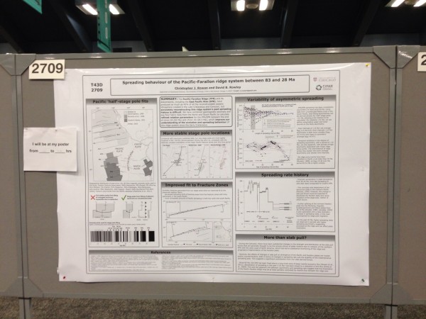
Most of my afternoon was, of course, devoted to manning my poster on the spreading history of the Pacific and Farallon plates (for those who are interested, the ePoster is currently available on the AGU Meeting site)

My poster in all its glory.

I’ve come to the conclusion that whilst talks at large meetings like AGU are generally thought to be more prestigious, they are more for when you want to advertise your work; if you actually want to discuss it, then in front of a poster is in many ways a better venue. I certainly got a lot of discussion, to the extent that my voice was feeling a little hoarse at the end of my stint. Not only did I get mostly positive comments and some good ideas for further work, but I also met a few online pals in the flesh for the first time, including Alex Witze (the Carl Zimmer of Earth Science reporting) and Rob Simmon, who is responsible for all the wonderful imagery produced by NASA’s Earth Observatory.

A good but tiring day, then. Only one more to go!

Categories: academic life, conferences, earthquakes, geohazards, teaching