
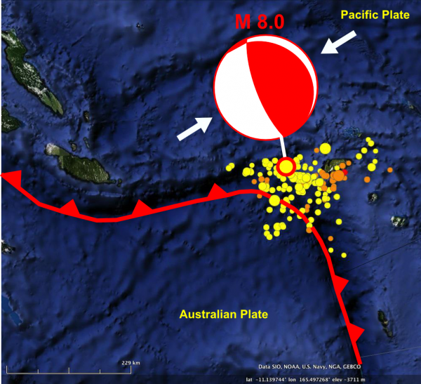
![]() On Tuesday night American time (Wednesday lunchtime local time), a magnitude 8 earthquake occurred near the Santa Cruz Islands, a set of small islands east of the Solomon Islands. In this region, the Australian plate is subducting to the north-east beneath the Pacific plate. The geometry of the plate boundary is quite interesting: this earthquake is located at the apex of a major curve in the trench, from roughly east in the direction of the Solomon Islands to south-west in the direction of Vanuatu and New Caledonia. The focal mechanism* for the event itself shows northeast-southwest compression, which is consistent with a rupture of the subduction thrust. At almost 30 km deep, the rupture did not produce displace the seafloor enough to produce a major tsunami, but it did produce a local tsunami that caused a fair amount of carnage on Lata, the principal island in the Santa Cruz group.
On Tuesday night American time (Wednesday lunchtime local time), a magnitude 8 earthquake occurred near the Santa Cruz Islands, a set of small islands east of the Solomon Islands. In this region, the Australian plate is subducting to the north-east beneath the Pacific plate. The geometry of the plate boundary is quite interesting: this earthquake is located at the apex of a major curve in the trench, from roughly east in the direction of the Solomon Islands to south-west in the direction of Vanuatu and New Caledonia. The focal mechanism* for the event itself shows northeast-southwest compression, which is consistent with a rupture of the subduction thrust. At almost 30 km deep, the rupture did not produce displace the seafloor enough to produce a major tsunami, but it did produce a local tsunami that caused a fair amount of carnage on Lata, the principal island in the Santa Cruz group.
Earthquakes in the Santa Cruz Islands region, SW Pacific, Feb 2-8th 2013. The NE-SW thrust focal mechanism of the M8 mainshock on 6th February is also shown.
One interesting thing about this event is that it appears to have had a well-defined foreshock sequence, with around a dozen earthquakes in the magnitude 5-6 range recorded in the 5 days before the main shock, close to its eventual location. I haven’t plotted them, but the focal mechanisms for the magnitude 6 events show thrust mechanisms very similar to the eventual main shock. In hindsight, we can interpret this as preliminary slip on the subduction thrust, prior to the main event. As ever, you should be aware that there was nothing about these earthquakes that told us this beforehand.
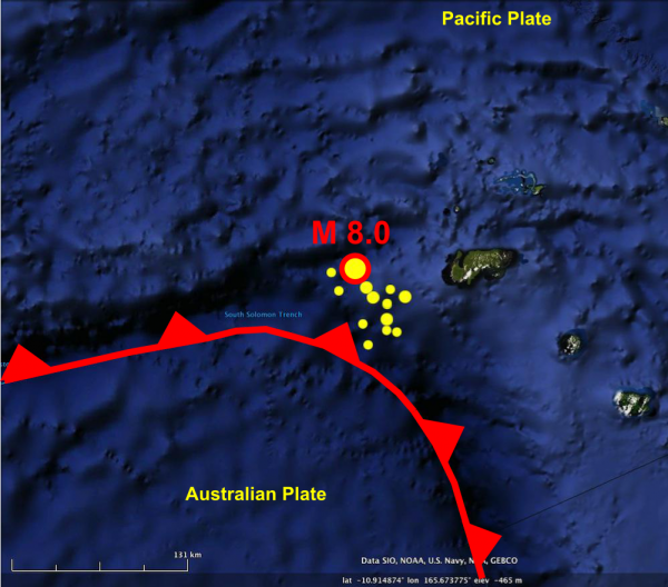
Magnitude 5+ earthquakes near the Feb 6th main shock on Feb 1st-5th (foreshocks).
The aftershocks are turning out to be a bit of a surprise. Of the nine aftershocks stronger than magnitude 6 recorded so far, not one of them is compressional: instead we’re seeing a mixture of extensional and strike-slip faulting.
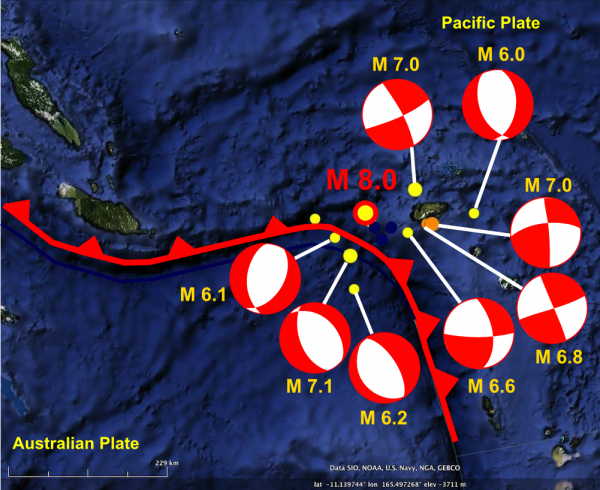
Location and focal mechanisms of magnitude 6+ aftershocks between Feb 6th and Feb 8th in the Santa Cruz Islands region.
Easiest to explain are the three large extensional events on the Australian plate just south of the trench, which are probably related to bending of the plate as it enters the subduction zone. North of the trench, there have been four Magnitude 6.6-7 strike slip earthquakes in the vicinity of Lata, and a magnitude 6 extensional event caused by east-west stretching further east, on the very edge of the aftershock zone. This makes it likely (but not certain) that the east-west striking focal planes for the strike-slip earthquakes to the west are the fault planes: east-west extension is more consistent with east-west shear.
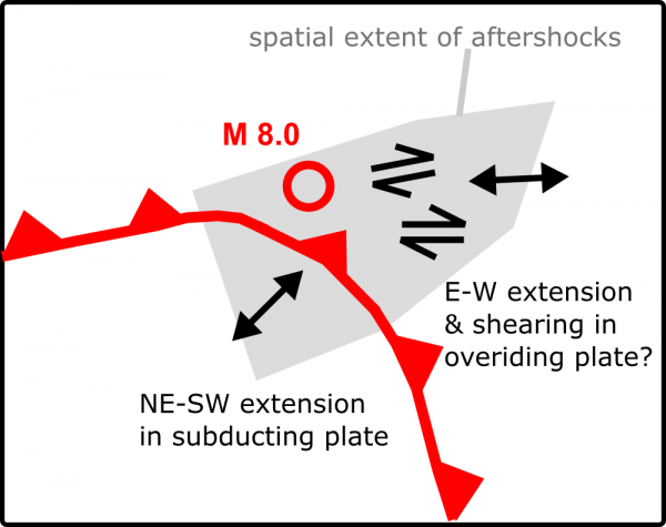
Tentative interpretation of the stress field associated with the aftershocks.
All the aftershocks north of the trench were located at 10-20 kilometres depth, which is at least 10 kilometres shallower than the main shock, suggesting that they are caused by deformation of the overriding Pacific plate. As to the cause, I can only speculate that it is something to do with the shape of the subducting plate in this region. The bending of the trench in this region suggests that as well as curving down into the mantle as it is being subducted, the Australian plate is also folded along a perpendicular axis, creating a kind of conically folded slab at the corner occupied by the Santa Cruz Islands. If this conical fold is widest at the surface where it enters the trench, then thrusting it forward and beneath the Pacific plate will cause some warping of the overlying crust to accommodate a suddenly more broadly arched Australian plate, leading to the extension and shearing we are seeing.
But as I said, that’s a highly speculative explanation, which may or may not make any sense to anyone but me. I’d attempt to sketch it but my ability to visualise three-dimensional structures far exceeds my ability to draw them, especially on a Friday night…


