Festering Questions from the West Virginia Chemical Spill

A post by Anne Jefferson
The massive impact of last week’s chemical spill into the Elk River in West Virginia continues to cause hardship for the up to 300,000 people affected by the water ban and to pose tough questions for scientists and authorities involved with assessing and mitigating the spill’s effects on central West Virginia’s water supply.

Before Thursday morning, West Virginia’s Elk River was a well-known river for fishing and the sole water supply for the city of Charleston and populations in parts of nine counties. On Thursday morning, West Virginia Department of Environmental Quality Division of Air Quality was alerted to licorice or anise odor and traced the source to a leaking tank at a Freedom Industries facility located on the bank of the Elk River. The leaking tank contained 4-methylcyclohexane methanol, a chemical used in frothing during the coal washing process. The tank has been described as “antique” and was made of riveted stainless steel, which is an old construction technique. Unfortunately, the leaking tank was located near the river bank, and up to 7500 gallons of the chemical made it into the river. (Here’s what the site looks like from the river) Even more unfortunately, the water intake for West Virginia American Water was located only one mile downstream. West Virginia American Water is the major water supplier for 9 counties in central and southwestern Virginia, including the state’s capital, Charleston. Water treatment plants typically aren’t designed to remove industrial chemicals, and West Virginia America Water wouldn’t even have known to test for this one. At some point Thursday afternoon, the dots were connected and a water ban was put in place for anyone served by the water supply. Residents, businesses, and institutional facilities were told not to use the water for drinking, cooking, bathing, or washing clothes or dishes. The only allowed uses are toilet flushing and fire fighting. As of Sunday afternoon, three days after the spill occurred, the water use ban is still in place, state and federal emergencies have been declared, and FEMA and the National Guard are distributing bottled water and water from tanker trucks.

Google Maps view of white industrial tanks adjacent to a river.

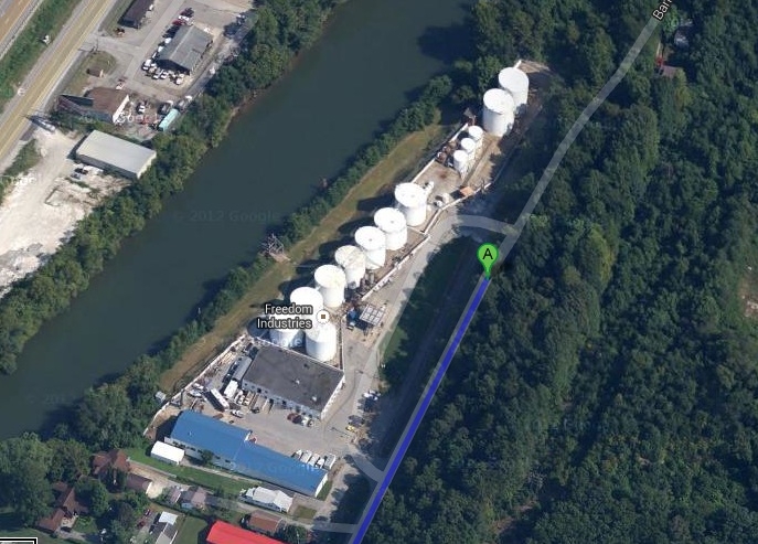
Freedom Industries site adjacent to the Elk River, upstream of Charleston, West Virginia. Image from Google Maps.

Google Maps of Elk River and surroundings.

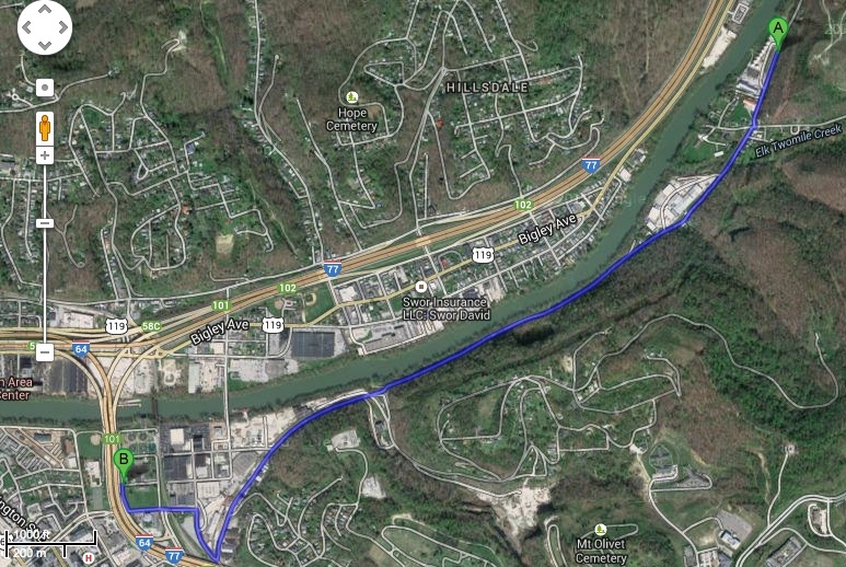
Point A indicates the Freedom Industries site and Point B indicates the water treatment plan. Image from Google Maps.

There aren’t a lot of data on the toxicology or safe levels of 4-methylcyclohexane methanol (MCMH) in water. We know that it is an organic solvent and a light non-aqueous phase liquid, which might be why there have been no reports of fish kills, since fish are hanging out in warmer, deeper pools at this time of year. Deborah Blum did some sleuthing and surmising from related chemicals, and so far the health effects appear to consist of a lot of people worried about symptoms but few people having problems clearly related to the spill. But the axiom of not ingesting industrial chemicals still stands. Officials are scrambling to find out what they can from the chemical’s manufacturer and to test samples to determine what level of contaminant is actually in the water supply. At some point, the state decided that a level of less than 1 part per million (1 ppm) of the contaminant was safe, and now the goal seems to be to have the water treatment plant consistently producing water at with contaminant levels lower than 1 ppm. There will also be some delay between samples being collected and the test results coming in, though it sounds like they may be making rapid on-the-ground strides in the rate at which they can test samples in four labs that have been set up for this task. Some reports say the state reported river water concentrations of MCMH had declined to 1.7 ppm on Friday, from 3 ppm. No numbers seem to have been released Saturday or Sunday, though NBC News is reporting on a news conference indicating 0 ppm going into and out the water treatment plant on Sunday morning. This article from the Bluefield Gazette gives some idea of the plan to flush parts of the massive water distribution system, which goes over mountains. All indications are that it will be days more before the water ban is lifted for everyone.

As an outside observer to this disaster, gleaning what I can from the media reports, here are my questions about the past, present, and future of the central West Virginia water supply.

  • Why was a tank farm allowed to locate on the river bank only a mile upstream of a major municipal water supply intake? And if the tank farm was upriver before the water treatment plant was built, what safety concerns were raised in selecting that site?
  • Were any special emergency procedures in place at either the industrial facility or the water treatment plant given this proximity? (I can find a risk management plan for the water treatment plant to deal with its risk of spilling chloride, but I can’t find anything similar for Freedom Industries or how the water treatment plant planned for risks of spills upstream from its facility. These plans may exist off-line.)
  • How was an acceptable maximum contaminant level of 1 part per million decided upon?
  • When the water treatment plant is producing less than 1 part per million of MCMH in the water supply, how will they test and ensure that all parts of the water distribution network are at that level?
  • What will the flushing recommendations be for water users? How will the recommended flushing times be determined?
  • Will there be longer term monitoring of MCMH levels at various points in the distribution network to ensure that levels remain below the acceptable maximum contaminant level?
  • Will there be long term studies of the environmental and human health effects of the exposure, particularly on vulnerable populations like children?
  • Most importantly, how will this incident change policy and procedures in this region, in West Virginia, in the coal processing industry, and in the nation?

Based on what I’ve learned, the risks of this human-caused disaster could potentially have been substantially mitigated by more stringent watershed planning that prevented the tank farm from operating so close to the river bank so close upstream of the water treatment plant and tighter regulation and routine inspection of the tank farm and its safety procedures. If the spill had still occurred even with those risk reductions, it would have been useful to have more information on the toxicology of the chemical that spilled (and all industrial chemicals) to provide better guidance on what maximum contaminant level is acceptable. As Deborah Blum points out, “Our Toxic Substances Control Act is more than 35 years old and we (by which I mean Congress) haven’t conjured up the backbone to update and strengthen it as of this date.”

This spill and its disruption of West Virginians lives shows what can happen when environmental regulations are not stringent, rigorous, and routinely enforced.  The spectre of 300,000 US residents unable to drink or bathe in their tap water for days on end should stick in our collective consciousness for a long time. We don’t need to invoke the threat of terrorists or climate extremes to disrupt our water lifelines; West Virginia reminds us that business as usual can do that too.

Categories: by Anne, hydrology, public science, society

The Spirit of Mawson expedition – harried by ice and media

A post by Chris RowanThe Highly Allochthonous family got pretty lucky on our trip to Antarctica: we enjoyed calm seas, including both ways across the infamously stomach-churning Drake Passage, and fairly clement weather every day of our trip.

Vessel amidst sea ice, Neko Harbour

Our Antarctic vessel, surrounded but not hemmed in by sea-ice, Neko Harbour. Photo: Chris Rowan, Dec 2013.

Meanwhile, on the other side of the continent, the MV Akademik Shokalskiy, on a cruise designed to follow in the footsteps of early 20th century explorer Douglas Mawson, found itself trapped in thick sea-ice by unfavourable winds.

Akademik Shokalskiy

The Akademik Shokalskiy has got a bit more up close and personal with the ice. Source: BBC

Fortunately, neither the ship nor its crew and passengers were in real peril, and the passengers have now been rescued. But their misadventures have not gone without criticism, most prominently highlighted by Andy Revkin at the New York Times. These criticisms basically boil down to two main points of contention:

  • the rescue efforts, which have diverted icebreakers from several nations from their scheduled duties, have heavily disrupted other Antarctic research: Revkin highlights how the speedy dispatch of the Australian icebreaker from their station in East Antarctica has delayed the offloading of supplies and research equipment.
  • the spectacle of climate scientists getting trapped in ice on an Antarctic research cruise has “energized climate change contrarians”, who have been loudly chortling about it online.

The first accusation can’t be dismissed out of hand, although the language in which it is expressed – describing it as an ‘unessential’ ‘bungled’ ‘misadventure’ that has badly disrupted ‘serious science’ (all words used in Revkin’s piece, and mirrored by his continued highlighting of criticism on his Twitter account, where ‘fiasco’ is a commonly used adjective) seems rather judgemental. You can’t question the disruption, but some of that appears to be just the nature of working in Antarctica. It’s a big, harsh, environment with long supply lines and only a limited pool of local resources, which means that any unscheduled events, such as your icebreaker getting stuck in ice itself, or your government taking a while to decide if it wants to fund itself or not, can have serious and long-lasting knock-on effects on everyone working down there. In an already disrupted season, seeing your supply ship sail off to rescue someone else is no doubt an additional frustration. But while it is pertinent to question whether, by trying to stick to a fixed itinerary rather than adapting to the prevailing conditions, the expedition took unnecessary risks, a strong apparent undercurrent of much of the criticism is that the cruise was not ‘real science’ and should never have been dispatched to Antarctica in the first place. Expedition leader Chris Turney has written a strong defence of its scientific merit, but personally, the implicit comparison to cruises like ours, which didn’t pretend to be anything more than tourism*, seems unfair.

As for the assertion that this has provided succour to the climate denial industry, colour me unconvinced. Long-term observation of the corner of the internet occupied by the self-proclaimed ‘sceptics’ indicates that you hardly need to throw them bones; they’ll seize onto any happening, anywhere, that they can trumpet as part of their narrative (regardless of the actual facts of the matter). In fact, from where I’m sitting in Ohio, it’s easy to predict what their fixation will be this week:

It's a bit chilly in these here parts right now. Forecast map from Weather Underground.

It’s a bit chilly in these here parts right now. Forecast map from Weather Underground.

Yes, the old ‘cold spell, therefore no climate change’ canard. Of course, there’s also a record heatwave in Argentina right now (something I personally experienced whilst dashing around Buenos Aires airport, on our somewhat less-than-smooth return journey to the northern hemisphere), and Australia has just had the warmest year on record, but we all know that warm-weather anecdata don’t count, right? Sadly, whilst managing to grasp that no one individual event can be definitively be used as evidence of anthropogenic climate change, there is a mysterious failure on the part of some to realise that the converse is also true.

*Antarctic cruise operators take seriously minimising damage to the unique and fragile environment we were privileged to see close-up, and we are hoping to share some of our experiences in future posts; but the only data we brought back was in our digital cameras.

Categories: Antarctica, climate science, public science

Highly Allochthonous’s 2013 adventures

A post by Anne JeffersonA post by Chris Rowan With a few hours of the year to spare in our current time zone, here’s a quick look back at some of the places your Highly Allochthonous bloggers have found themselves in the last 12 months.

We started the year in England, visiting Chris’s family and friends. Anne shared a picture of the Thames at London, and here’s a picture of the River Welland and an old mill race at the market town of Stamford.

Two streams joining with a grassy area in the middle.

The River Welland at Stamford. The mill race to the right was cut by 1640, but a mill is recorded here in the Domesday Book of 1086.

Later in January, Anne participated in Science Online 2013. While the sessions were invigorating as always, the major highlight for Anne was a tour of the partially buried urban stream Pigeon House Creek, lead by Scott Huler. Sadly, Anne never managed to blog about the experience, though she has had a partial draft post written for months, and she used the experience during a lecture in her urban hydrology course.

A typical view inside the buried streams. Except, most of the time we didn't have any view of daylight, but the picture comes out better if I give you a glimpse of the light at the end of the tunnel.

A typical view inside the buried streams. Except, most of the time we didn’t have any view of daylight, but the picture comes out better if I give you a glimpse of the light at the end of the tunnel.

February and March saw Anne traveling a lot – to Wisconsin for a stream restoration conference, to an acid mine drainage site in Ohio, and to the flat and snowy Fargo, North Dakota. We also did some local explorations, introduced the third and youngest member of our blogging team, and added the high albedo geodog to the family. In April and May, we stayed close to home. GeoKid’s class toured the Kent State Geology Department, and we appreciated the beauty of spring in northeastern Ohio.

bookshelf made of rocks with reading nook. Purple flowers bloom above.

Fabulous sculpture on the Kent State campus, set off perfectly by the spring flowers. Photo by A. Jefferson, May 2013.

At the end of June, we set off on a megaventure that took us all of July and into early August. Over the course of 35 days, we went from Ohio-Minnesota-Oregon-Minnesota-UK-Minnesota-Ohio. We blogged about various bits of the trip, such as our drive across the flat midwestern US, appreciation of volcanoes and their water in Oregon (Mt. Hood and the Three Sisters area), historical beauty of Colchester, UK, and the amazing geologic features of Northern Island (Giants Causeway FTW!). We also had a brief foray into the Republic of Ireland to see the Brú na Bóinne world heritage site, and the spectacular passage tomb and stone art at Newgrange.

Triangles and spirals carved into a huge rock at the base of a wall with smaller rocks piled on top.

5000 year old art decorating the outside of the Newgrange passage tomb in Ireland. The inside, where no photos are allowed, is even more spectacular. Photo by A. Jefferson, July 2013.

By August, we were mostly just glad to be home. Anne reveled in watching two dams come down on the Cuyahoga River, and Chris took an exploratory trip to Shenandoah National Park and environs. Anne feels bad she never properly blogged the dam removals, and Chris waves a fist in frustration at the government shutdown that scuttled his class field trip to the sites he had scoped out.

In September, October and November, we enjoyed exploring autumn in northeastern Ohio, as Anne led her fluvial class on 5 field trips and we spent four consecutive weekends in and around Cuyahoga Valley National Park. This was a nice calm (travel-wise at least) period before a flurry of travel to wrap up the year.

fall colors and students in and around a gravel bed stream

Students survey the West Branch of the Mahoning River during a (luckily) warm early November afternoon. Photo by A. Jefferson.

In December, we were gone pretty much all month. We started with slightly overlapping trips to San Francisco to participate in AGU, while simultaneously giving and grading final exams. Then, a mere 48 hours after Chris got back from AGU, we left on our most far-flung adventure of the year. The Highly Allochthonous blogging team spent December 16-30th in Tierra del Fuego and Antarctica. If we have but one blogging resolution for the next year, it is to do a reasonable job sharing the spectacular landscapes we were so privileged to experience. But it’s going to take us some time to sort through the 30 GB of photos and video we collected on our trip. So for starters, here is a small teaser.

Glacier spilling into a fiord. Glimpses of steep bare rock in foreground and background.

Glacier at Neko Harbor on the Antarctic Peninsula. Photo by A. Jefferson, December 2013.

Adelie penguins on a bit of pack ice in the Antarctic Sound. Photo by A. Jefferson, December 2013.

Adelie penguins on a bit of pack ice in the Antarctic Sound. Photo by A. Jefferson, December 2013.

We’ve certainly had an amazing adventure-filled year, and we look forward to seeing what 2014 brings. To our readers, we wish you the happiest of new years.

Categories: Antarctica, geology, photos

Highly Allochthonous at AGU

A post by Anne JeffersonA post by Chris RowanIt’s that time of year again! The AGU Fall Meeting: where downtown San Francisco suddenly becomes infested with tens of people carrying poster tubes enthusiastically muttering such incomprehensible terms as ‘kinematic’ and ‘hyporheic’ (image below courtesy of the AGU).

http://instagram.com/p/htNqS4NBQ2/

Both of us are going to be wandering around the Moscone Centre for some part of the week, although not, for the most part, at the same time.

Anne is attending from Monday until Thursday morning. She is giving a talk on Wednesday morning:

  • H31L-08. Transient Storage versus Hyporheic Exchange in Low-gradient Headwater Streams.
  • Time: Wednesday 9:45-10:00 AM
  • Place: Room 3018, Moscone West
  • Session: Groundwater-Surface Water Interactions: Physical, Biological, and Chemical Relevance.

And co-chairing a session on Thursday morning:

  • H41N – Groundwater-Surface Water Interactions: Physical, Biological, and Chemical Relevance.
  • Time: Thursday 8:00-10:00 AM
  • Place: Room 3018, Moscone West

And although she is not there, she is a coauthor (with colleagues back at UNC in North Carolina) on a student poster.

  • H51C-1198: Water and Nutrient Export Patterns of Urban Watersheds with Stormwater Control Measures.
  • Time: Friday, 8:00-12:20 pm
  • Place: Hall A-C, Moscone South
  • Session: Chemical, Isotopic, and Chronologic Tracers to Understand the Fate and Transport of Nutrients in Watersheds.

Chris is arriving late Wednesday afternoon and will be at the conference Thursday and Friday. Unfortunately, this means he will miss his grad student Matt Harding’s poster session on Wednesday morning:

  • T31C-2521: The influence of pre-existing basement structures on salt tectonics in the Upper Silurian Salina Group, Appalachian Basin, NE Pennsylvania: results from 3D seismic analysis and analogue modelling.
  • Time: Wednesday, 8-12:20 pm
  • Place: Hall A-C, Moscone South
  • Session: Geodynamic Modeling of Lithosphere Deformation: Advances and Challenges.

Matt is investigating the effect of pre-existing basement topography on salt tectonics during the Appalachian orogeny, and Chris encourages you swung by to ask him some (friendly!) questions.

Chris is also giving a talk late on Thursday afternoon:

  • T44C-08: Signals of dynamic coupling between mantle and lithosphere beneath the axis of the East Pacific Rise.
  • Time: Thursday, 5:45-6:00 pm
  • Place: Room 302, Moscone South
  • Session: Linking Earth Surface Dynamics and Deep Tectonic Processes.

Of course, AGU is as much about bumping into people in the corridors and poster halls as formal presentations. Hopefully, we’ll see some of you around the place.

Chris enjoying AGU. Beer optional. Image: American Geophysical Union (but obviously fair use, I'd say).

Chris enjoying AGU. Beer optional. Image: American Geophysical Union (but obviously fair use, I’d say).

Categories: academic life, conferences

Scenic Saturday: snow over Thanksgiving

A post by Anne JeffersonA post by Chris RowanIt’s been a busy semester for us here in Ohio, and whilst Thanksgiving has been more of an opportunity to try and catch up than a true holiday, we did take some time out for the traditional Thanksgiving Dinner. Traditional for Anne, anyway, and it’s a tradition Chris can get behind, with a few modifications (such as preventing sugar and marshmallows being added to perfectly good sweet potatoes).

As a consequence, we’ve also been making sure to take enough exercise to work off the less welcome consequences of a large roast dinner and copious leftovers. Our location on the edge of the snowstorm that made its way up the Eastern US earlier this week has made these excursions cold, but pretty darned scenic.

The low sun shining through trees the makes a lovely pattern on the snow. Photo: Chris Rowan, 2013.

The low sun shining through trees the makes a lovely pattern on the snow. Photo: Chris Rowan, 2013.

Bare trees against a grey winter's day. Photo: Chris Rowan, 2013.

Bare trees against a grey winter’s day. Photo: Chris Rowan, 2013.

Snow melti-forms - probably not a proper word, but it should be. Photo: Chris Rowan, 2013.

Snow melti-forms – probably not a proper word, but it should be. Photo: Chris Rowan, 2013.

Stream in snow.

You’d never know that this little stream wandering into a wetland had emerged from being buried in a storm drain just a few hundred meters upstream. Photo: Anne Jefferson, 2013.

view from edge of ice covered pond

A lovely pond for observing, but not testing, the ice. Photo: Anne Jefferson, 2013.

I love spotting needle ice in the exposed soil. Needle ice forms when the soil is above freezing, the air is below freezing, and capillary action brings water towards the surface where it freezes. Photo: Anne Jefferson, 2013.

I love spotting needle ice in the exposed soil. Needle ice forms when the soil is above freezing, the air is below freezing, and capillary action brings water towards the surface where it freezes. Photo: Anne Jefferson, 2013.

We’re both very thankful to live in a place with lots of nice, accessible walking paths.

Categories: bloggery, by Anne, photos