Neoproterozoic signs of life

A post by Chris RowanResearchBlogging.orgFossils older than the base of the Cambrian – 542 million years ago – are not exactly abundant, so it was interesting to see not one, but two interesting papers in the latest issue of Geology that describe fossils from the Neoproterozoic period, from 1000 to 542 million years ago.
The first paper reports the discovery of 565 Ma trace fossils found at Mistaken Point in Newfoundland. Mistaken Point is the location of a nice section across the Cambrian boundary, and hosts the oldest known fossilised Ediacaran macrofauna (at least 10 million years older than the ones I’ve seen in Namibia).

mistaken4.jpg
Ediacaran fossil, Mistaken Point. Source

Ediacarans have generally been interpreted as immobile, bottom-dwelling filter feeders, but Liu et al. have discovered a horizon in the sequence that appears to show that something was moving around:

Mistaken_Point_Trace.jpg
Source: Liu et al., Figure 2

These trail-like features are found on the top of a fine green mudstone unit, laid down in deep water, that is capped by a volcanic tuff (which probably helped in their preservation). Liu et al. found 70 tracks about 1cm wide and up to 17 cm long. The crescent shaped ridges within the grooves, and their marginal ridges indicate that they have been formed by sediment being pushed aside and piled up by something moving through it. The lack of any consistent orientation, and the fact that a fair number are curved, indicating a change in the direction of motion, makes it unlikely that they are formed by something being passively dragged along by a current.
It is not known what manner of creature might have made the trails, as none are preserved at the same stratigraphic level; the only possible clue is that the tracks sometimes end in circular impressions which might mark where the creature that made the trails was resting before or after moving. Whilst the authors say that the possibility of them being made by giant single-celled protists cannot be discounted, they remark that modern sea anenomes can leave similar trails..

anenome_trail.jpg

It seems, then, that an anenome-like creature (in terms of body form and/or mode of life, at least, if not direct descent) is their favoured culprit.
The second paper concerns these unusual microfossils from the Tindir group of northwestern Canada:

Tindir_microfossil.jpg
Scale bar is 15 μm. Source: Macdonald et al., Figure 1

The little mineralised scales are quite interesting; the appearance of mineralised body parts is also associated with the Cambrian diversification, although the whys and wherefores are still disputed. Modern scale-forming groups of micro-organisms are also all eukaryotes, which suggests (although does not prove) that these critters were too. So from an evolutionary perspective, they’re quite interesting; unfortunately the sequence they were found in was not particularly well-dated, so based mainly on fossils like this they were placed close to the Cambrian boundary. With some more thorough mapping and geochemical correlations, however, Macdonald et al. have shown that the fossil-bearing formations were deposited prior to glacial deposits linked to the period of extreme “Snowball Earth” glaciations between about 750 and 635 million years ago. This means that the microfossils pictured above must be at least 750 million years old. Since the Snowball Earth theory proposes an extreme winnowing of most life due to the whole Earth being frozen over, this is a valuable glimpse at what might have occupied the pre-Snowball world, and tests the biological part of the hypothesis.
Taking a wider perspective, what both of these papers demonstrate is that whilst the the dawn of the Cambrian clearly marked the diversification of mobile, active animals and biomineralisers, the story of their first origins appear to have begun earlier, possibly much earlier; something to bear in mind when we are trying to link biological changes on the ancient Earth to wider geological events.
Liu, A., Mcllroy, D., & Brasier, M. (2010). First evidence for locomotion in the Ediacara biota from the 565 Ma Mistaken Point Formation, Newfoundland Geology, 38 (2), 123-126 DOI: 10.1130/G30368.1
Macdonald, F., Cohen, P., Dudas, F., & Schrag, D. (2010). Early Neoproterozoic scale microfossils in the Lower Tindir Group of Alaska and the Yukon Territory Geology, 38 (2), 143-146 DOI: 10.1130/G25637.1

Neoprotfoss_timescale.png

Categories: fossils, geology, paper reviews, past worlds, Proterozoic

Is tweeting bad for blogging?

A post by Chris RowanIt’s been pretty much a year since I first climbed aboard the Twitter bandwagon, and I’ve been musing of late of how it has gone from being something I didn’t really get at all, to becoming a fairly central part of how I interact with the Internet. It’s usually where I first get wind of big events (the Haiti earthquake, for example), it guides me to interesting news both within and without the world of science; and it keeps me up to date with the doings and thoughts of a lot of my online friends. But, I realise, not all of them, and I am starting to wonder if a problem is brewing – a disconnect between those who choose to tweet, and those who do not. Thus I’ve been thinking fairly seriously about what effect my changed online habits have had in my interactions with the world of blogs, particularly the geology-centric part of it. There have certainly been changes that may potentially have had a negative impact: whereas before I used to check my aggregated geoblogging feed over breakfast, now I’m much more likely to check my Twitter feed. Time I might have spent writing a comment on somebody’s post might now be spent writing a tweet (or retweet) about it instead – which might drive some traffic to said post, but does potentially divorce some of the conversation about a post from the post itself (and by extension, the author).

Continue reading

Categories: bloggery

Stuff I linked to on Twitter last week

A post by Chris RowanGoogle Maps alphabets
http://www.telegraph.co.uk/technology/picture-galleries/5757548/The-Google-Maps-alphabet-UK-an-A-to-Z-of-the-British-Isles.html
http://www.telegraph.co.uk/news/picturegalleries/howaboutthat/5214494/Rhett-Dashwoods-Google-Maps-alphabet.html
NOVA Geoblog reviews "Reading the Rocks" by Marcia Bjornerud [adding to Amazon wish list in 3..2..]
http://nvcc.edu/home/cbentley/geoblog/2010/02/reading-rocks-by-marcia-bjornerud.html
(via @Geoblogfeed)
More geotagging propaganda:
http://geofroth.org/?p=475
[You can do things like this
(via @drjerque)
The Other California: Be a Geotripper Geoblogger for a Day! Crowd-sourced geoblogging!
http://geotripper.blogspot.com/2010/02/other-california-be-geotripper.html
(via @Geoblogfeed)
Shell’s David Hone on iPad vs CRU pseudoscandal: We love tech, but science not so much…
http://tinyurl.com/ydssrnh
(via @mtobis, @EnergyCollectiv)
Icy volcanic breccia [as in, ice clasts WITHIN volcanic breccia…]
http://nvcc.edu/home/cbentley/geoblog/2010/02/icy-volcanic-breccia.html
(via @Geoblogfeed)
Renaissance of Technicolor dinosaurs continues. Last week’s researchers were "in the Stone Age".
http://scienceblogs.com/notrocketscience/2010/02/the_renaissance_of_technicolour_dinosaurs_continues_and_the.php
(via @edyong209)
New maps of Pluto! Best until New Horizons within 6 months of 2015 flyby
http://www.nasa.gov/mission_pages/hubble/science/pluto-20100204.html
(via @elakdawalla, @plutokiller)
How can we bridge between geologic and human timescales to help avert disaster? Read AGU’s Haiti blog:
http://www.agu.org/blog/Haiti/?p=48
(via @theAGU)
Free access to AGU papers on Caribbean plate for a limited time.
http://www.agu.org/news/archives/2010-02-02_CarribeanPlatePapers.shtml
(via @theAGU)
OK, that’s pretty darn cool : Termite Mounds from Space: Myrmecos Blog.
http://myrmecos.wordpress.com/2010/02/04/finding-termites-on-google-earth/
Must-red Eureka column on science and journalistic balance by @markgfh.
http://www.timesonline.co.uk/tol/news/science/eureka/article7011355.ece
Why the denial camp is winning (and we’re all losing) the climate wars.
http://scienceblogs.com/islandofdoubt/2010/02/why_the_denial_camp_is_winning.php?utm_source=selectfeed&utm_medium=rss
(via @ScienceBlogs)
Searching for Africa’s Last Glaciers in the Mountains of the Moon, Uganda.
http://www.e360.yale.edu/content/feature.msp?id=2237
(via @highlyanne, @YaleE360)
Cool, if small, picture: Fukutokuoka no Ba Undersea Volcano Erupts.
http://mdn.mainichi.jp/mdnnews/news/20100204p2a00m0na017000c.html
(via @GeologyDotCom)
Some nice photos of dikes that fed Deccan flood basalts, India.
http://suvratk.blogspot.com/2010/02/plumbing-beneath-deccan-volcanic.html
Excellent post at Eruptions setting recent Yellowstone eq swarm in context. All structure, no magma.
http://scienceblogs.com/eruptions/2010/02/the_structure_of_calderas.php
To end this week’s space budget discussions on a cheerier note: Cassini Mission extended until 2017. Huzzah!
http://www.nasa.gov/mission_pages/cassini/whycassini/cassini-20100203.html
Ediacaran animal trails? Evidence of ‘anemone-like’ movement in 565 Myr rocks from Newfoundland
http://www.sciencedaily.com/releases/2010/02/100203085914.htm
(via @geosociety)
Single-celled organism grows into ‘monstrous beach ball’ 20 cm diameter. A single cell!
http://www.newscientist.com/article/dn18468-zoologger-living-beach-ball-is-worlds-largest-cell.html
(via @rowanNS)
Wind abraded ventifacts on Mars and Earth: IAG Planetary Geomorph image of the month.
http://www.psi.edu/pgwg/images/feb10image.html
(via @highlyanne)
Wow. Another incredible Hubble image… of an asteroid collision in space!
http://blogs.discovermagazine.com/badastronomy/2010/02/02/hubble-captures-picture-of-asteroid-collision/
(via @DiscoverMag, @BadAstronomer)
Airborne Radar Image of Post-Quake Haiti . Some interesting background: 40km fault rupture, propogating W from epicentre.
http://www.jpl.nasa.gov/news/news.cfm?release=2010-037
If civilisation collapses, how much of our knowledge would future humans be able to retrieve? Not much…
http://www.newscientist.com/article/mg20527451.300-digital-doomsday-the-end-of-knowledge.html
(via @rowanNS)
Such an important point: Writers are Made not Born
http://serc.carleton.edu/earthandmind/posts/born.html
Simulations suggest rocky Earth-mass worlds could have formed in Alpha Centauri binary system. But in what orbits?
http://www.newscientist.com/article/dn18451-what-alien-worlds-orbit-our-nearest-star.html
Chemistry Creates Self-Stirring Liquids (w/video). Wonder if this relevant for core/mantle?
http://www.wired.com/wiredscience/2010/01/self-stirring-liquids/
(via @ScienceSoWhat)
Something rotten in the state of palaeontology. Decay removes acquired characters first. Interesting!
http://www.nature.com/news/2010/100131/full/news.2010.45.html/ [subscription only]
(via @NatureNews)
Online gallery for geology & art exhibit. Interesting, wish was more description of pieces.
http://www.twowallgallery.com/geosapiens.html
(via @clasticdetritus)

Categories: links

Man-made mud volcano starting to look like a real volcano

A post by Chris RowanIt’s been a while since my last update on Lusi, the allegedly/probably drilling-triggered mud volcano near Sidoarjo, Indonesia. But the NASA Earth Observatory has just released this image, taken last autumn:

Lusi_Oct08.jpg
Lusi,October 2009. Source: NASA Earth Observatory

My first thought on seeing this was, “Woah, where’d that mountain come from?” In the last images I had seen, Lusi had from above was effectively a big muddy pool, contained within man-made earthworks, with a steaming vent in the middle. This had been pretty much the case for the previous couple of years.

lusi_Oct08.jpg
Lusi, October 2008. Source: CRISP

Now, it’s a big muddy pool with a big steaming hill in the middle. By looking through the satellite snapshots put out every couple of months by the Centre for Remote Imaging, Sensing and Processing at the University of Singapore (of which the October 2008 image above is one), you can see that over the last 12 months or so Lusi appears to have started building up instead of out, with the causeways and dams around the vent being gradually swallowed up by the grey ooze.

Lusi_May09.jpg
Lusi, May 2009. Source: CRISP

Lusi_Sep09.jpg
Lusi, September 2009. Source: CRISP

Lusi_Dec09.jpg
Lusi, December 2009. Source: CRISP

It seems, then, that Lusi has entered a new phase of its life. I wonder if this growth has anything to do with subsidence in the area?

Categories: geohazards, Lusi

Haiti’s seismic future

A post by Chris RowanIt’s now been just over 3 weeks since a magnitude 7.0 earthquake hit Haiti, devastating the capital Port-au-Prince and many other surrounding towns and villages. The sheer scale of the disaster – the tens, even hundreds of thousands who have lost their lives, or their homes and families – has been quite overwhelming. As the country struggles to recover and rebuild, and with aftershocks still occasionally shaking things up, one question that people want answered is, are we safe yet? When is the continued seismic activity going to stop? Will there be another devastating earthquake in the future – and if so, when? And what about the rest of the northern Caribbean?
Let’s start with the aftershocks. When a fault ruptures, the surrounding crust will be deformed by the motion. The upper crust is brittle, so will accommodate this deformation by rupturing at further points of weakness like minor faults and fractures, causing aftershocks. As of February 2nd, there have been 62 significant aftershocks powerful enough to be picked up by the global seismograph network. The USGS provide a handy map (which is being updated over time; this is a static snapshot):
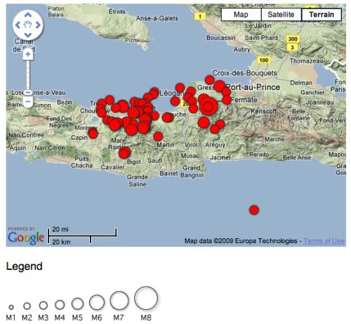
Haiti_Aftershocks.jpg
Source: USGS

If we plot the frequency of aftershocks over time, we see that the vast majority occurred in the 24 to 36 hours following the main shock (which occurred quite late on the 12th January). This period also included about 15 aftershocks with a magnitude greater than 5, whilst there has only been one (a magnitude 5.9) since.

HaitiAFS.png

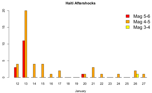
This makes sense: most of the response to the local redistribution of stress in the crust following a large earthquake will occur almost immediately, as weak points are pushed beyond their point of failure. But there will be some places where stress was increased almost to the point of failure, but not quite over it, and will finally fail a bit later. This means that although there doesn’t seem to have been a significant aftershock for a week (although there were probably smaller ones that weren’t properly picked up by distant seismometers), there’s still the risk of a strained part of the crust finally giving, producing a sizeable aftershock, for some time yet. Which is why this USGS assessment predicted, based on statistical modelling of the aftershocks in the week or so following the mainshock, 2 or 3 aftershocks of magnitude 5 or greater would occur in the 30 day period after 21st January, with a 25% chance of a magnitude 6 or greater aftershock.
However, focussing on just the aftershocks ignores what seems to be the real concern about future seismic risk in Haiti: namely, that only an approximately 40 km long segment of the Enriquillo Fault ruptured on January 12th, and in the same way that stress redistribution around the ruptured section causes aftershocks, stress transferred onto adjacent, and as yet unruptured, sections of the Enriquillo Fault might well trigger large earthquakes on them. This worry has a precedent. In the aftermath of the magnitude 9.0 Boxing Day 2004 Sumatra earthquake, John McCloskey and his colleagues at the University of Ulster calculated that this rupture had placed more stress on the subduction megathrust further to the southeast. Less than a month after publishing a warning of the increased seismic hazard, there was a magnitude 8.7 earthquake in the area in question. It seems that a similar process may possibly be at work in Haiti; here’s a map of the stress changes resulting from the January 12th earthquake, as modelled by Eric Calais (I originally found this on a brilliant collection of scientific imagery for the Haiti earthquake being collated by the Group on Earth Observations). Note that the aftershocks (circles) are clustered in the red areas indicating the largest stress increases, but also note the stress increases in the region surrounding the Enriquillo fault both to the east and the west.

coulomb_ec.jpg
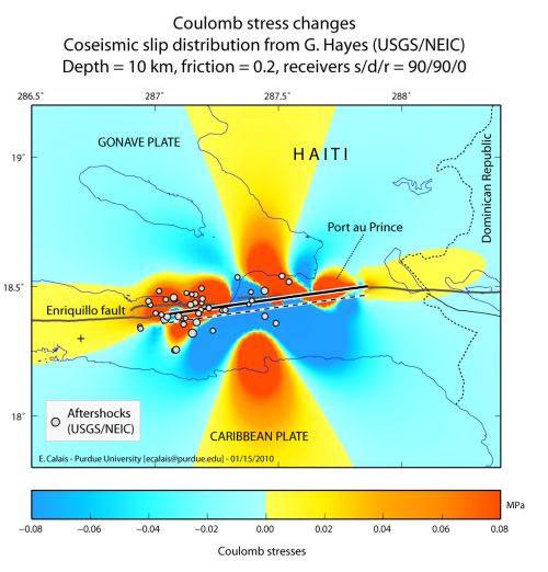
Modelled stress changes for the Jan 12 earthquake: thick line marks the modelled rupture length.

As always when talking about triggering earthquakes, it is important to emphasise that this is just giving already strained bits of crust an extra nudge that might cause them to rupture a bit earlier than they otherwise would. The worry comes from the fact that these fault segments might just have enough strain stored up on them to be primed for such triggering. The historical map below shows that a large section of the Enriquillo-Plantain Garden Fault system running through southern Haiti and the neighbouring Dominican Republic last ruptured in a sequence of earthquakes concentrated in a 20 year period between 1750 and 1770, meaning that prior to January 12th, more than 250 years’ worth of tectonic movement between the North American and Carribean plates (or, more precisely, the fraction of that tectonic motion that is accommodated by this fault) was being stored as elastic strain across the Enriquillo fault.

N_Caribbean_paleoseismicity.jpg
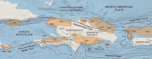
Source: New York Times

Eric Calais was co-author of a 2008 paper (pdf) that used GPS measurements to estimate the rate that strain was building up on the Enriquillo fault, extrapolated from that the total elastic strain accumulated on the Haitian part of the fault zone since the last big earthquake, and calculated that if it was all released in a single earthquake, it would have had a magnitude of approximately 7.2. Some of that strain has now been released by the magnitude 7.0 three weeks ago, but it might be less than you instinctively think: the earthquake magnitude scale is logarithmic, so a magnitude 7.2 earthquake represents about 1.6 times more energy than is released by a magnitude 7.0 earthquake. This leads to the conclusion that the unruptured parts of the Enriquillo fault, particularly the part to the east of January’s rupture (which is still very close to Port-au-Prince), still represent a significant seismic hazard.
Another look at the earthquake history of Haiti and the Dominican Republic also reveals a second potential earthquake hazard. The northern Septentrional Fault System seems (from current, GPS-derived, deformation patterns), to accommodate just as much tectonic motion as the Enriquillo system. The part of the Septentrional Fault that runs through Haiti last ruptured in 1842, and has built up enough strain to potentially cause a magnitude 6.9 earthquake if it all ruptured in one go. But there are no historically recorded earthquakes on the part that runs through the Dominican Republic, and paleoseismic studies (which look for disruption of datable horizons in trenches dug along the fault) indicate it probably last ruptured almost 1000 years ago. If that’s right, there’s enough strain stored up on this section to cause up to a magntiude 7.5 earthquake.
To sum, up then, despite January’s quake releasing a fair amount of the strain built up at the plate boundary, there’s still plenty more yet to be released in this part of the Caribbean. Seismologists can’t really predict if the recent earthquakes have increased the chances of this remainder being released sooner rather than later; more data is definitely required about how the crust has responded to the last month of shaking and stress changes, both through close study of comparative radar imagery (several examples are up at the Group on Earth Observations site), and getting on the ground to make more GPS measurements. However, what should not be ignored is that regardless of the details, this region is always going to be at risk from these sorts of earthquakes. The strain still being stored on the Enriquillo and Septentrional faults is going be released at some point in the decades to come, and it’s just a question of when, and how (multiple ruptures, or one big one?). But even then, the danger will not disappear – the slow yet inexorable motion of the North American and Carribean plates will place strain across these faults again – including the segment that caused so much carnage three weeks ago – and eventually they will rupture again. After that, the earthquake cycle will restart once more until they rupture again, and again, and again. The tectonic rhythms of our planet are slow, and a few hundred years of inactivity on a fault is a mere eyeblink when its lifetime can be measured in hundreds of thousands, even millions, of years.
Whilst geologists can not – and may not ever – be able to predict exactly when an earthquake will hit, we are getting to the stage where we know where they are most likely to strike, and roughly how big and how frequent they are likely to be. The northern Carribean is seismically active, and will remain so until what is, for us, an unimaginably distant point in the future. Making the people who live there aware of the seismic risks is important: even after 50 years pass and last month’s tragedy fades from the Haitians’ memories, geologists need to press home the fact that it will happen again, and people should plan and build – and live – accordingly.

Categories: earthquakes, geohazards, geology