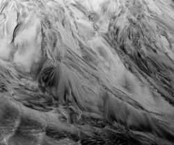
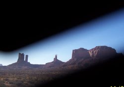
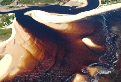
My regular readers are probably quite used to my occasional bouts of silence on this blog, but my low internet profile in the past fortnight has been for the quite justifiable reason that I was away on holiday. I had a blast, and unsurprisingly I quite blatantly indulged my inner geo-nerd when selecting my destination, which means several cool blog posts are in the pipeline. As a teaser, I give you the following two photos, and invite you to guess their geographical and geological provenance.
No prize in on offer save kudos for your geo-sleuthing skills, which will hopefully discourage those of you who communicate with me via other channels, and therefore already know where I’ve been hiding, from cheating. Guess away!
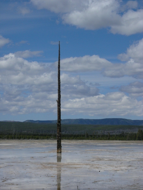
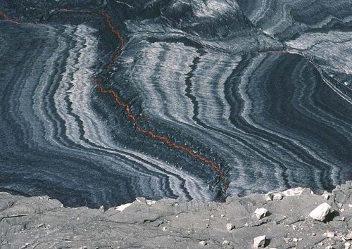
~1500 year old basaltic lava landscape with no surface drainage
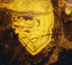
to looking like this?
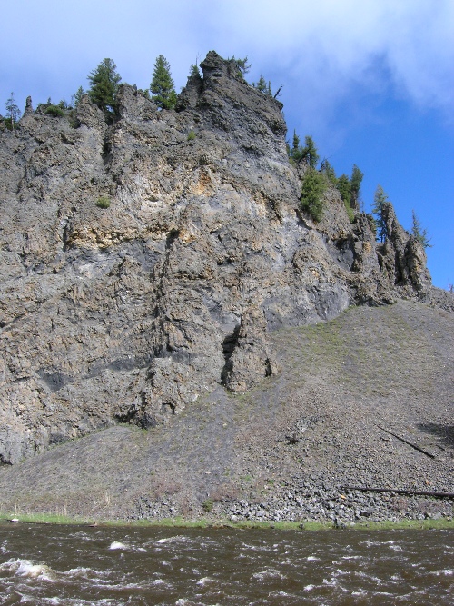
2 Million year old landscape on basaltic lava. Note steep slopes and incised valleys
Find out in my new paper in Earth Surface Processes and Landforms.
Hint: Using a chronosequence of watersheds in the Oregon Cascades, we argue that the rates and processes of landscape evolution are driven by whether the water sinks into the lava flows and moves slowly toward springs with steady hydrographs or whether the water moves quickly through the shallow subsurface and creates streams with flashy hydrographs. Further, we suggest that this water routing is controlled by an elusive landscape-scale permeability which decreases over time as processes like chemical weathering create soil and clog up pores in the rock. And as a bonus, because of the high initial permeability of basaltic landscapes, the formation of stream networks and the dissection of the landscape appears to take far longer than in places with less permeable lithologies. Jefferson, A., Grant, G., Lewis, S., & Lancaster, S. (2010). Coevolution of hydrology and topography on a basalt landscape in the Oregon Cascade Range, USA Earth Surface Processes and Landforms, 35 (7), 803-816 DOI: 10.1002/esp.1976
Note: This post is a collaborative effort by Anne and guest blogger Will Dalen Rice, a graduate student in the Department of Geography and Earth Sciences at UNC Charlotte. He had the misfortune of taking a couple of courses from Anne this semester and has become a certified stream junkie, going out on rainy nights to see how high Charlotte’s urban streams are running.
Most cities were started around the idea of available surface water resources. Development and misuse of our streams (ex: “dilution is the solution to pollution”) has resulted in the modern urban stream. These streams are straight and good at carrying storm water, full of sediment and pollutants, and they lack good habitat for plants and animals. Now that we are beginning to notice how degraded and trashed these city waterways are though, scientists and engineers are beginning to attempt to address the form and function of these waterways to hopefully return them to a more “natural” (or at least aesthetically pleasing) state. While there are many stream restoration techniques, they often involve mechanical manipulation of the stream channel and banks and the planting of riparian plants along the stream corridor. As the streamside ecosystem redevelops, the idea is that health of the stream will also improve (leave it to nature to clean up our messes, given the chance).
For large urban streams, the standard practices in stream and habitat restoration are sometimes not possible, often because decades of infrastructure development have pinned the stream into a narrow corridor. So other approaches need to be considered, and Robert Francis and Simon Hoggart of King’s College London discuss ways that existing artificial structures can be put to work to mitigate some of the ecological impacts of urbanization. In the specific case of the River Thames in England, habitat development has been observed on man-made structures, and furthermore, certain types of man-made structures grow life better than others. Francis and Hoggart show that indeed plants (and therefore animals) can develop in a riparian zone better when brick and wood and rougher materials are used over concrete and steel. If concrete and steel already exist, adding brick and wood can further trap sediment for habitat growth (like gluing a cup of dirt to a steel wall). They suggest that this should become standard practice when thinking of restoration efforts in large, urban waterways.
The NOAA’s Northwest Fisheries Science Center says Thornton Creek in downtown Seattle exemplifies “the challenges facing rehabilitating urban streams.” But a look at the NOAA picture below shows that this stream is also emblematic of a riparian ecosystem that has developed within the constraints of the existing structures and maybe even a spontaneous model for the sort of restoration that Francis and Hoggart envision. Francis, R., & Hoggart, S. (2008). Waste Not, Want Not: The Need to Utilize Existing Artificial Structures for Habitat Improvement Along Urban Rivers Restoration Ecology, 16 (3), 373-381 DOI: 10.1111/j.1526-100X.2008.00434.x
Welcome to the latest edition of the Accretionary Wedge geoblogging carnival. We’ve been delighted by the response to our call for your favourite geological imagery, and the number of nominations we’ve received has been matched by their diversity – images have ranged from the microscopic to continental scales, from the depths of geological time to the present day, from the igneous to the sedimentary. The only way we could think of to do this smorgasboard of earth science justice was in the form of a visual dictionary, matching the images you’ve provided to the feature or process that they exemplify. Clicking on each image will allow you to see it in all its full-resolution glory at the original post, which in many cases also provides some more background on the geological feature or process depicted. Fun, pretty and at least a little bit educational – we hope you’ll have as much fun looking through our little glossary as we had putting it together.
A
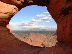
Arch, natural – Formed by differential erosion at the base of a narrow ridge.
Coastal zone – region where interaction of terrestrial and marine processes occurs. Morphology can take the form of a beach, barrier island, delta, cliff, or wave-cut platform.
Conglomerate – coarse sedimentary rock with rounded clasts.
Photo: Ogallala/Arikaree formation near the Pawnee Buttes in north eastern Colorado (conglomerate butte landscape) from Russ Dale
D
Debris flow – type of mass wasting where large clasts are carried in a mud-water mixture.
Photo: Debris flows, Pacific NW. From Anne Jefferson
Dessication cracks – fractures formed by the shrinkage of clay, silt, or mud as it dries out from subaerial exposure.
Photo: Riviere de Terre – natural ‘artwork’ featuring dried, cracked clay. From Pools and Riffles.
Diagenesis – post-depositional alteration of sediments at low temperatures and pressures, often leading to the growth of new minerals in response to changing geochemical conditions.
Photo: pendant calcite crystals precipitated within meteoric aquifers during late Ordovician sea-level fall, Appalachians. From Suvrat.
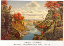
Differential weathering – divergence in the degree of weathering and erosion of different lithologies exposed to the same environment. Differential weathering is a factor in the formation of arches, buttes, and mesas, as well as steep slopes where some layers form vertical cliffs and other rock layers have subvertical exposures.
Picture: Letchworth State Park in Castille, NY, painted by Levi Wells. From John van Hoesen.
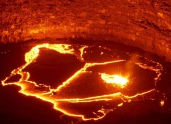
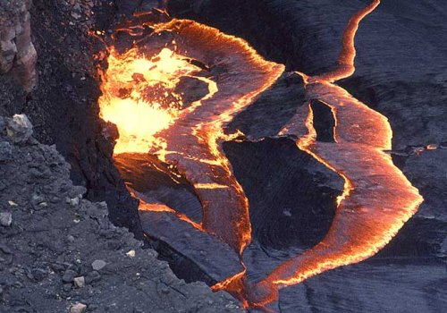
As cool geo-imagery has poured in for the upcoming Accretionary Wedge*, I have been pondering what I should throw into the collective album. Eventually, I decided that when it comes to dramatic imagery that ties into my geological interests (albeit somewhat obliquely), you can’t beat a lava lake.
A vat of bubbling molten lava seems more like something from a bad disaster movie than real life, but sometimes there is the right balance between vent shape and eruption rate for a lava lake to form. The one shown above is found in the crater of Erta Ale, a basaltic shield volcano found in the Afar rift region of Ethiopia. What is really cool about this picture is what is going on at the lake surface. The uppermost layer of lava has cooled and solidified, forming a thin crust on top of the molten lava beneath. This surface rind has the same composition, but different mechanical properties, than the fluid it covers, much like ice on a winter lake. The churning of the convecting lava beneath has broken apart this crust into a number of different slabs; in the picture above, the boundaries are marked by the lines of bright molten lava, creating a dramatic natural jigsaw puzzle. The same convection currents jostle the slabs against each other, moving them apart in some places, with new upwelling lava cooling and solidifying in the gap, and in other places pushing them back into the depths of the lake to be remelted.
Although you should all know by now that the Earth’s mantle is not molten, it is divided mechanically in the same way as the Erte Ale lava lake. The upper mantle forms the colder, stronger, lithosphere, rigid enough to hold its shape; the lower mantle forms the warmer, weaker, asthenosphere. Convection currents in the asthenosphere move heat from the Earth’s interior towards the surface, and in the process also drive the motion of the overlying lithospheric plates. So the Erta Ale lava lake is in fact a fabulous natural analogue for plate tectonics, and because in this case the convecting medium is molten, moving at centimetres per second rather than centimeters per year, we can see processes that take tens of miliions of years on a global scale happening in just a few hours. It’s quite compelling to watch.
*it’s my carnival and I’ll submit after the deadline if I want to.
Nice plan for content warnings on Mastodon and the Fediverse. Now you need a Mastodon/Fediverse button on this blog.
For lot's more videos on soil moisture topics, see Drs Selker and Or's text-book support videos https://www.youtube.com/channel/UCoMb5YOZuaGtn8pZyQMSLuQ/playlists
[…] Announcing STORMS | Highly Allochthonous on Recent News […]


 Note: This post is a collaborative effort by Anne and guest blogger Will Dalen Rice, a graduate student in the


Nice plan for content warnings on Mastodon and the Fediverse. Now you need a Mastodon/Fediverse button on this blog.