![]() The last few weeks have seen me overwhelmingly busy with #sciwrite, #gradingjail, #proposalpurgatory, and #deathbydataanalysis, and it doesn’t look like I’ll come up for air for a little while longer. But to give the blog a little freshening, and help me avoid grading early on a Saturday morning, I thought I’d show a picture of my homeland, the Driftless area of southeastern Minnesota and western Wisconsin.
The last few weeks have seen me overwhelmingly busy with #sciwrite, #gradingjail, #proposalpurgatory, and #deathbydataanalysis, and it doesn’t look like I’ll come up for air for a little while longer. But to give the blog a little freshening, and help me avoid grading early on a Saturday morning, I thought I’d show a picture of my homeland, the Driftless area of southeastern Minnesota and western Wisconsin.
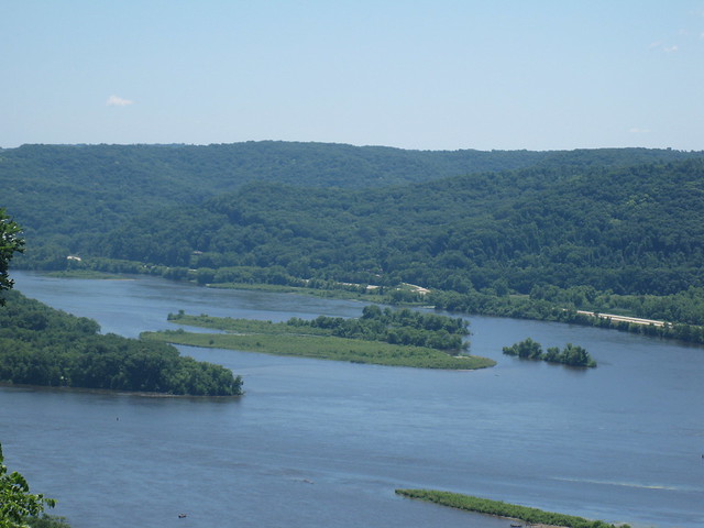
This is a view from the top of Brady’s Bluff in Perrot State Park near Trempealeau, Wisconsin. I am looking south towards Minnesota, across the Upper Mississippi River. The river here is not the classic, loopy meanders of the lower Mississippi. Instead, it is termed “island braided.” The channel is wide and subdivided by multiple, somewhat stable islands. Some of these islands have been around since the first mapping of the river in the 1870s. Other islands appear after each large flood, but then seem to persist. Still others have their whole existence occur within a few decades.
Looking from the left of the picture, the first treed island is mapped as Island 81 by the Mississippi River Commission in the 1890s. Parts of the island have upland oak forest vegetation with huge old trees, and lots of poison ivy. The next low island with shorter trees is one my family calls Gull Island, because it first appeared as the waters receded after the flood of 1993. At first, it was an emergent sandbar that had accumulated around a piece of large wood on which gulls liked to rest. Now it is completely covered by 4 m or higher willows. Behind Gull Island is Lower Mobile Island. This island first appeared in the aftermath of the 1965 flood, and was the subject of study by Winona State University biology professors for several decades. Upstream of Lower Mobile Island is Upper Mobile Island. This island was created when water levels in the river were raised in 1935 by the construction of the Lock and Dam System. It has mostly been eroding ever since. Behind Lower Mobile Island, you might be able to identify another discrete line of trees before your eye reaches the Minnesota shore. That line of trees is all that remains of Lower LaMoille Island, another created by raised water levels in 1936. Upper LaMoille Island disappeared from the surface in the 1990s. Finally, there’s the river bank on the Minnesota side and the classic bluffland topography for which the Driftless Area is famous.
These islands are special to me because their dynamism is really what got me hooked on the field of fluvial geomorphology. I did a science fair project on the geomorphology and history of the islands when I was 16, and I have an MS student who worked on them before being lured to the wilds of Alaska. I’m not sure he’ll ever finish his thesis or that I’ll ever get a paper out of it, but if you want to learn more about the dynamic Upper Mississippi, you should learn from Cal Fremling, the man who wrote the book: “Immortal River: The Upper Mississippi in Ancient and Modern Times.” He’s the biology professor that started studying the Mobile Islands back in 1965.


Nice plan for content warnings on Mastodon and the Fediverse. Now you need a Mastodon/Fediverse button on this blog.