It has been 60 years since a magnitude 9.5 earthquake struck the Chilean coast near Valdivia. The stats for this earthquake remain pretty mind-blowing even today. It is still the largest earthquake ever recorded – over 20% of the Earth’s seismic energy output over the last 120 years was released by this one earthquake. The rupture was around 1000 km long, and there was possibly as much as 40m of fault motion in some places!
The Valdivia earthquake and plate tectonics
One important thing to remember about this earthquake is that it happened in the era before we’d fully worked out plate tectonics. We were close, but there was still so much we didn’t quite understand.
- Now we know that the deep trenches found off the coast of places like Chile are just the surface manifestations of giant thrust faults that dip very shallowly into the Earth – the subduction zones where the oceanic crust created at the mid-ocean ridges tens of millions of years before is returned to the mantle from whence it came. We didn’t know that then.
- Now we know the recipe for giant earthquakes: you need fast plate motions and a long, shallowly dipping fault, which results in a huge surface area where the rocks stay shallow and cold enough to fracture, rather than flow, when stressed. Subduction zones are where these ingredients are present, so are where the Earth cooks almost all of the largest earthquakes. We didn’t know that then, either.
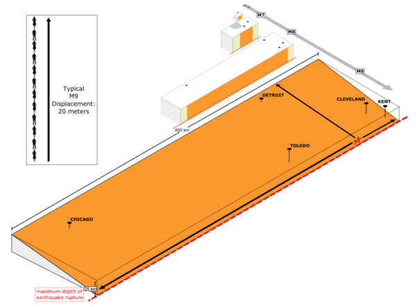
- We also didn’t know that because the trenches are where these massive faults reach the seafloor, a large rupture pushes up a massive bulge of water that then rapidly collapses outwards – a tsunami. This amplifies and extends the deadly reach of the giant earthquakes. We – tragically – didn’t understand which earthquakes generate the large tsunami, and why.
This earthquake, and another large subduction earthquake in Alaska 4 years later, provided the key evidence for large horizontal motions on large thrust faults at subduction zones: a building block of what became plate tectonics. But these events also helped us to understand earthquake hazards much more clearly. We still can’t predict when big earthquakes will happen, but now we can understand where they happen, and what they do. This means we can save lives – through informed preparation before, warning of imminent tsunami during, and disaster response after. Today, an event like the Valdivia earthquake would be shocking, and devastating. But, at some level, we can at least comprehend that is it something the planet can do, in places like this.
We’ve come a long way since 1960.
The Earth’s long and drawn out response to a giant earthquake
Did you know that even after 60 years, the Earth is still ‘feeling’ the effects of this massive earthquake? Plate motions are slow and continuous, but the faults are not perfectly smooth. There is a stop-start cycle of slowly building up elastic strain that is suddenly released in abrupt, energetic earthquakes once enough strain has built up to overcome friction on the fault surface
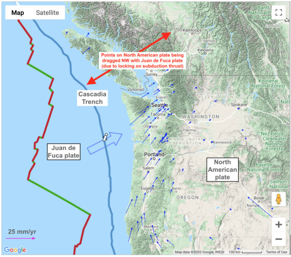
It’s been 320 years since the last big Cascadia quake, and GPS data shows it building up for the next one. The subduction thrust is locked by friction, so the coast on the overriding North American plate is being pushed inland as it moves with the subducting Juan de Fuca plate.
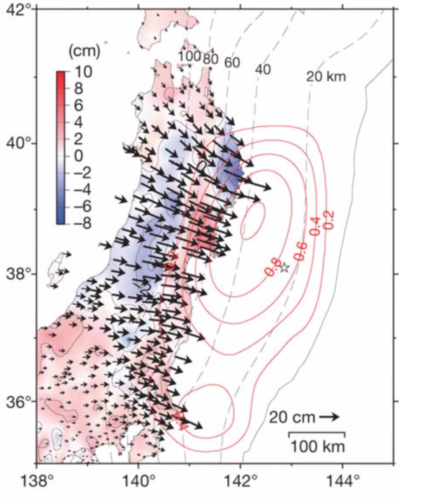
When a giant earthquake earthquake finally happens, the accumulated strain is released and the deformed part of the overriding plate rapidly heads back seawards, as we see here for the M9 Tohoku earthquake in 2011.
But here’s where it gets interesting: that seaward motion doesn’t stop when the earthquake does. Here’s GPS motions for the three months following the 2011 magnitude 9 Tohoku earthquake. The motions are much slower – centimetres in months rather than metres in minutes – but they are still in the same direction, suggesting they are a continuation of the process set in motion by the rupture.
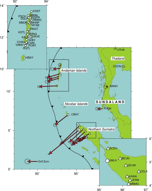
This is not an isolated observation: here’s data for a year after the 2004 magnitude 9.2 Sumatran earthquake which shows similar seaward motion.
Some of this motion is due to afterslip: further motion on the fault surface itself. Many aftershocks are a response to this, but some weaker – or weakened – parts of the ruptured surface will creep aseismically as well. But the massive stresses imparted by these earthquakes also affect the deeper warmer parts of the Earth that flow – rather than fracture – in response to this change. Afterslip effects die away quickly with time, so after a few years this ‘visco-elastic’ response dominates. Furthermore, this flow can continue for a very long time from a human’s (or an earthquake’s!) perspective. Which is where the 1960 Chilean quake comes in. GPS data show that the inner coastal region is still moving seaward rather than landward.
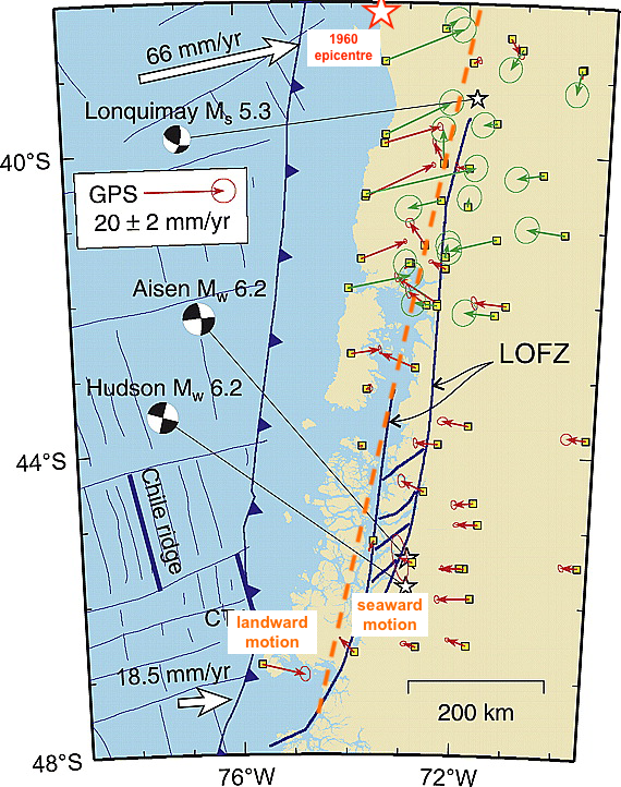
Eventually, the arrows further inland will change direction too, and the whole region will start moving landward, as it is in Cascadia. But it hasn’t got there yet. The Earth has a long memory, a fact reiterated by the canonical example of this kind of response: the isostatic rebound still affecting the bits of the Northern hemisphere which were under thick ice sheets until about 10,000 years ago.
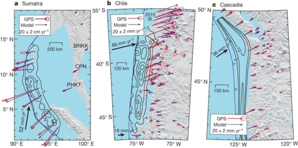
This figure from an excellent overview of the “Subduction Earthquake Cycle” allows GPS data from Cascadia, Sumatra, and Chile at different points in their earthquake cycle to be directly compared. The only thing to be careful about is that there are two sets of arrows on these figures: the red arrows show the actual observed motion, and the blue arrows show the results of modelling that includes a visco-elastic component due to flow of the mantle.


Nice plan for content warnings on Mastodon and the Fediverse. Now you need a Mastodon/Fediverse button on this blog.