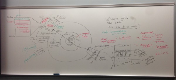
![]() One of the first things I do in my introductory geology class is talk about the structure of the Earth. Knowing the names, composition and physical properties of the different layers is an important foundation for the rest of the course, which means I fret about presenting the information in a clear and memorable manner*. This year, I decided to try a slightly different approach to in the past: I started my lecture by drilling an imaginary borehole down into the Earth from our lecture room. We discussed how what we were drilling through changed as we crossed the Moho, the lithosphere-asthenosphere boundary and the core-mantle boundary, and then crossed them again as we came up at the antipode of NE Ohio, which lies in the Indian ocean off Australia. Rather conveniently, this meant I had a good opportunity to discuss the differences between oceanic and continental lithosphere. It seemed to work pretty well. This is what the board looked like at the end of my lecture:
One of the first things I do in my introductory geology class is talk about the structure of the Earth. Knowing the names, composition and physical properties of the different layers is an important foundation for the rest of the course, which means I fret about presenting the information in a clear and memorable manner*. This year, I decided to try a slightly different approach to in the past: I started my lecture by drilling an imaginary borehole down into the Earth from our lecture room. We discussed how what we were drilling through changed as we crossed the Moho, the lithosphere-asthenosphere boundary and the core-mantle boundary, and then crossed them again as we came up at the antipode of NE Ohio, which lies in the Indian ocean off Australia. Rather conveniently, this meant I had a good opportunity to discuss the differences between oceanic and continental lithosphere. It seemed to work pretty well. This is what the board looked like at the end of my lecture:

The whiteboard following my Earth Structure lecture. I ended up having to move a table which restricted my access to the right hand side of the board in the middle of the lecture. I’m sure my class thought this was very amusing.
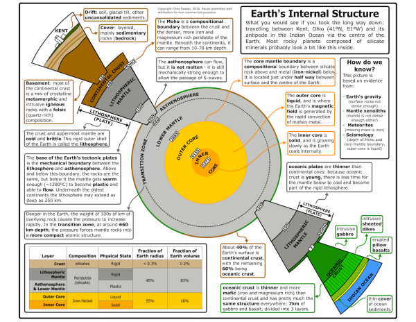
I gave the students blank cross-sections to fill in with all the information as we went, but then I thought that maybe I could give my students an even better study resource. I took the rough figure I had created in Inkscape to work out how to arrange all the information in the cross-section, spruced it up and added text boxes explaining all the most important information, and voilà:

The Earth, Down From Kent, Ohio. Click here for a large version.
I think it turned out pretty well. Anyone who finds this useful is welcome to use it with attribution; if you want the .svg file so you can modify it to fit your location, get in touch.
*a constant worry for most of the course, to be honest.


Comments (1)