![]() Four years ago on Sunday, Haiti, and particularly its capital, Port-au-Prince, was devastated by a shallow magnitude 7.0 earthquake, which killed many tens, and possibly hundreds of thousands of people*, and left more than a million people homeless. Even today, the effects of the earthquake linger: rebuilding is still a work in progress, and 150,000 people are still living in temporary accommodation.
Four years ago on Sunday, Haiti, and particularly its capital, Port-au-Prince, was devastated by a shallow magnitude 7.0 earthquake, which killed many tens, and possibly hundreds of thousands of people*, and left more than a million people homeless. Even today, the effects of the earthquake linger: rebuilding is still a work in progress, and 150,000 people are still living in temporary accommodation.
As a geologist, I am also watching with concern as one of the poorer countries in the world struggles to increase its resilience to future earthquakes. For this was not a one-off event: located close to the active plate boundary between the North American and Carribean plates, and with many large, seismically active onland faults throughout the region, Haiti and neighbouring countries like the Dominican Republic will certainly experience more large earthquakes in future years, decades, and centuries; how devastating they might be to these countries’ inhabitants depends not just on the size and location of the quake, but also on the strength of buildings and infrastructure, and the preparedness of the population.

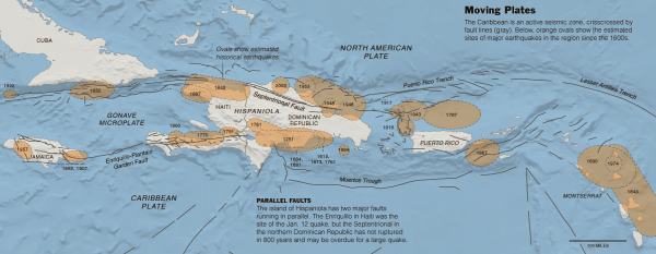
Major earthquakes in the Northern Caribbean since the 1600s. Source: The New York Times
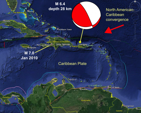
On the anniversary of the Haiti earthquake, we have been reminded of that underlying fact, with a magnitude 6.4 earthquake shaking Puerto Rico in the late evening local time, on the very day of Haiti’s sober anniversary. The focal mechanism is transpressional, indicating either left-lateral strike-slip with a bit of thrusting along a east-west oriented fault shallowly dipping to the south, or thrusting with a bit of right-lateral strike-slip along a steep northwest-southeast oriented fault. Both of these are consistent with the overall northeast-southwest convergence between the North American and Caribbean plates**

Map of the Caribbean, showing the location and focal mechanism for the 12th Jan 2014 earthquake off the coast of Puerto Rico, and the location of the 12th Jan 2010 Haiti Earthquake
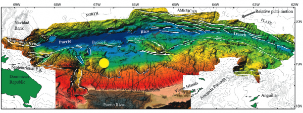
It’s actually quite difficult to work out which of the possible fault planes is the real one. The plate boundary in this region is associated with the Puerto Rico Trench. On Twitter, Jascha Polet (@CPPGeophysics) pointed to this nice, recent bathymetric map of the region, to which I’ve added the location of the recent earthquake. The major fault in the area seems to be the E-W trending Bunce Fault, which is interpreted as a strike-slip fault – it is also described as being steeply dipping in seismic data, so seems unlikely to be the fault that ruptured here. There is also a recent extensional graben with NW-SE trending faults a little to the east. I’ve suggested that the emerging pattern of aftershocks could indicate a rupture on a south-dipping fault propagating north towards the surface, which is not unreasonable but hardly definitive.

Bathymetry of the Puerto Rico Trench. Location of the Jan 12 2014 earthquake is marked by a yellow dot. Source: USGS
Fortunately in terms of human impact, compared to the Haiti earthquake this earthquake was smaller in magnitude and also located both off the coast and deeper underground (28 km rather than 13 km). These factors all reduced the surface shaking to the extent that damage and casualties seem to be minimal. Nonetheless, this was a strikingly timed reminder that even when attention is rightly focussed on recovering from the last natural disaster, we still need to pay some attention to the risk from future ones, lest the next big rupture also repeat the human misery.
*it’s not easy to estimate the death toll from a massive natural disaster when you don’t have good ‘before’ records, but even the lowest estimates are still pretty devastating
**if you want to get technical, there’s probably a microplate or two involved in the deformation across this plate boundary, but the big picture is sufficient in this case.


Comments (1)