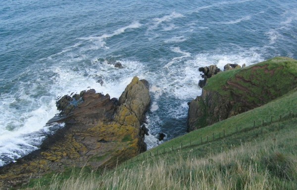
![]() I’m a strong advocate of geoheritage – the idea that there are places in the world worthy of protection because of their geological importance. They can either be places that vividly illustrate a geological process, or clearly record an important event in Earth history; or they have historical importance as a place where such processes or events were first recognised by our scientific forefathers. Siccar Point, on the east coast of Scotland, is a place where both apply (as they often do): it is not only a place to take students to show them a textbook angular unconformity, and allow them to trace their eyes and fingers across the vast gulfs of Deep Time, but it’s also the place where James Hutton first saw his ideas about vast stretches of time occupied by endless cycles of rock formation and uplift in the flesh (or, if you’re being pedantic, in the rock). If any place is worthy of preservation for future geologists, it’s here.
I’m a strong advocate of geoheritage – the idea that there are places in the world worthy of protection because of their geological importance. They can either be places that vividly illustrate a geological process, or clearly record an important event in Earth history; or they have historical importance as a place where such processes or events were first recognised by our scientific forefathers. Siccar Point, on the east coast of Scotland, is a place where both apply (as they often do): it is not only a place to take students to show them a textbook angular unconformity, and allow them to trace their eyes and fingers across the vast gulfs of Deep Time, but it’s also the place where James Hutton first saw his ideas about vast stretches of time occupied by endless cycles of rock formation and uplift in the flesh (or, if you’re being pedantic, in the rock). If any place is worthy of preservation for future geologists, it’s here.
So I was understandably concerned when I picked up some worrying chatter that suggested that Siccar Point was threatened by a new pipeline being built by vegetable growers R&K Drysdales to discharge waste water from vegetable washing into the sea. The “Save Siccar Point” website claims:
…a company is planning to ruin the location by digging a trench just a few meters east of this iconic location, lay a pipeline, and then fill that trench with concrete. This will cause permanent damage to the rock-bed and leave a visible scar at this important location forever.
Their plan is to dig a trench across a scientifically sensitive and important area, fill it with concrete, and dump their waste straight into the sea…
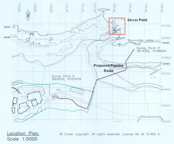
However, I was also a bit perplexed, since I know that Siccar Point is designated as a Site of Special Scientific Interest (SSSI), which means that it is protected from development; any planning application that truly threatened the site’s geological integrity would not be approved – or at least, should not be approved. It seemed rather unlikely that Drysdales would submit an application that didn’t at least attempt to minimise the impact on the SSSI. To their credit, Save Siccar Point do link to the planning application so we can examine what is actually being proposed. Here’s a map of the proposed pipeline:

Route of the proposed waste water pipeline near Siccar Point.
This shows that the planned outflow is at least 100 m down the coast from Siccar Point itself. You might be able to see something from the top of the cliffs if you were actually searching for it (it will be buried until it is below the waterline); but as far as I can tell you wouldn’t be able to see it at all from the locality itself. It certainly wouldn’t appear on any of the photos or video in my detailed post on Hutton’s unconformity. More importantly, they have clearly added a dogleg to the route, lengthening the pipeline and moving it away from Siccar Point itself. This suggests that Drysdales are at least aware of the potential impact on the SSSI and are attempting to minimise it – as they would have to, to get approval. You can argue over whether what they are proposing is sufficient, of course; but personally, I can’t see this really impeding or degrading the experience for future visiting geologists. An opinion I share with Scottish National Heritage, who have added a submission that specifically states:
“We do not consider that the proposed development will impact on the geological interest of Siccar Point Site of Special Scientific Interest (SSSI) due to its location outwith the boundaries of this site.”
Is it worth keeping an eye on this? Yes. Would I prefer, in an ideal world, for this pipeline to be further away from Siccar Point? Probably. But if it goes in as planned, will it destroy some irreplaceable geo-heritage? Not as far as I can see. Don’t panic!
See also: a statement from the Geological Society of London (which also boils down to, “Don’t panic!”), and Drysdale’s response to Save Siccar Point Campaign’s concerns, and the many submitted objections that it has inspired.


Comments (10)