![]() The Great Rift Valley marks where East Africa is slowly attempting to break away from the rest of the African continent, at a rate of less than a centimetre a year. At the north-eastern end of the rift, where it links to the oceanic spreading centres in the Red Sea and the Gulf of Aden, it has come very close to succeeding, producing the Afar triangle. Low, hot and arid, and home to numerous volcanoes and ultra-saline lakes, it’s the closest thing we have to an onland oceanic spreading centre – a structure that is normally found beneath 4 kilometres of water.
The Great Rift Valley marks where East Africa is slowly attempting to break away from the rest of the African continent, at a rate of less than a centimetre a year. At the north-eastern end of the rift, where it links to the oceanic spreading centres in the Red Sea and the Gulf of Aden, it has come very close to succeeding, producing the Afar triangle. Low, hot and arid, and home to numerous volcanoes and ultra-saline lakes, it’s the closest thing we have to an onland oceanic spreading centre – a structure that is normally found beneath 4 kilometres of water.
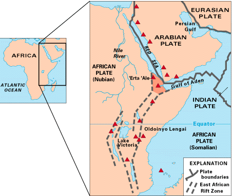
The Afar triangle is located at the junction between the East African continental rift, the Red Sea and Gulf of Aden oceanic rifts. Source: USGS
At the beginning of last week, Nabro, a volcano that has not been previously active in historical times, began to erupt, with ash clouds and a new lava flow spotted in satellite imagery. The Volcanism Blog and Eruptions are doing their usual excellent job of covering the eruption, but this event was also accompanied by some interesting seismic activity, which I thought was worth looking at in a bit more detail.
The global seismometer network detected 13 magnitude 4 or greater earthquakes near the border between Ethiopia and Eritrea on Sunday 12th June, all within a 20 km radius of the main caldera. The two largest quakes in this sequence had a magnitude of 5.7, occurred within 30 minutes of each other, and both had extensional focal mechanisms that indicated that the crust was being stretched – or pushed apart – in a northeast-southwest direction (the USGS information pages for these earthquakes are here and here).
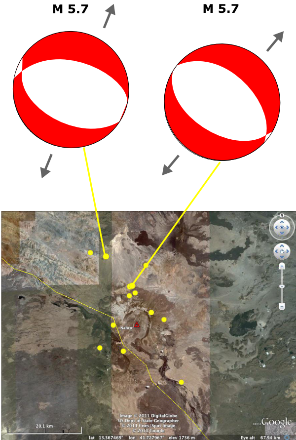
Earthquakes around Nabro on the 12th June, showing the extensional focal mechanisms for the two largest events in the sequence.
The reason I found this interesting was that it reminded me of a paper published a couple of years ago describing a massive dike injection event in the Afar triangle in 2005. Magma rising through the crust opened a 60 kilometre long, linear fracture beneath the surface and forced itself in, pushing the crust apart by up to eight metres; a process very reminiscent of what goes on at true oceanic spreading centres. One notable feature of the accompanying seismic activity was that most of the larger earthquakes had focal mechanisms showing northeast-southwest extension. There was also an associated volcanic eruption: at Da’Ure, a fissure vent of Dabbahu.
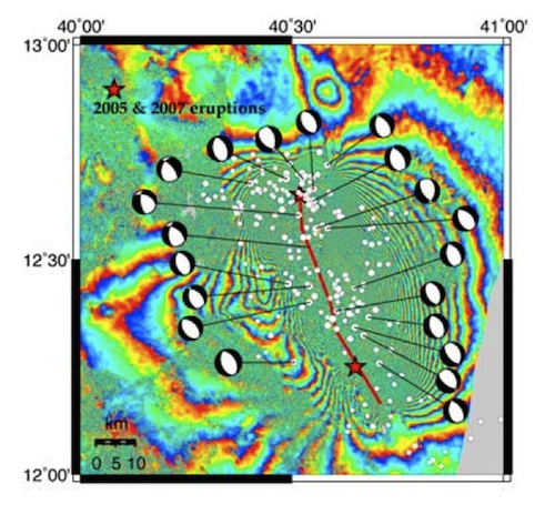
Focal mechanisms for the major earthquakes in the 2005 Dyke injection sequence. From Ayele et al., 2009 (see text for link).
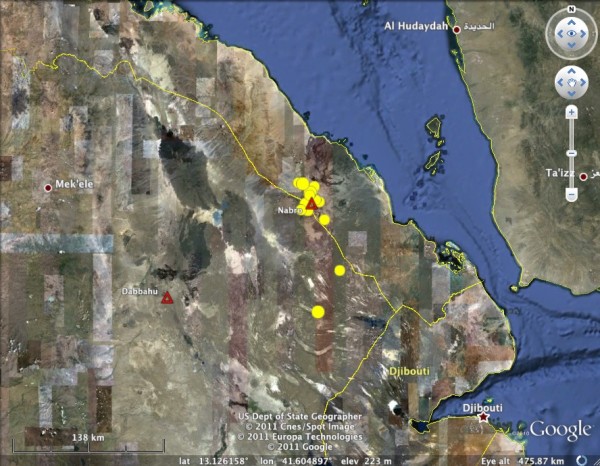
Location of the recent activity compared to the 2005 diking event centred on Dabbahu.
The 2005 diking event occured about 150 kilometres to the southwest of the current activity. Both are obviously linked to the regional extension associated with rifting. What is less clear is if the recent seisimicity – and the eruption of Nabro – can also be linked to dike injection at depth. In 2005, the seismic activity went on for a couple of weeks, and the migration of earthquake locations from northwest to southeast over time clearly showed the movement of injected magma along the dike away from the initial injection point. In contrast, the recent bout of seismic activity appears to have been much more short-lived, and although the earthquakes are (very roughly) distributed along a northwest-southeast trending line, there is no obvious migration of the epicentres over the course of the sequence. This may just be an issue of scale: last week may have seen a much smaller-scale injection of magma than in 2005, but in both cases the earthquake focal mechanisms were controlled by the regional extension, which will produce many more such events as Afar continues its slow transformation into a small ocean basin
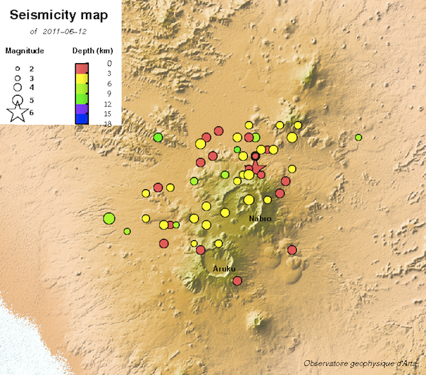
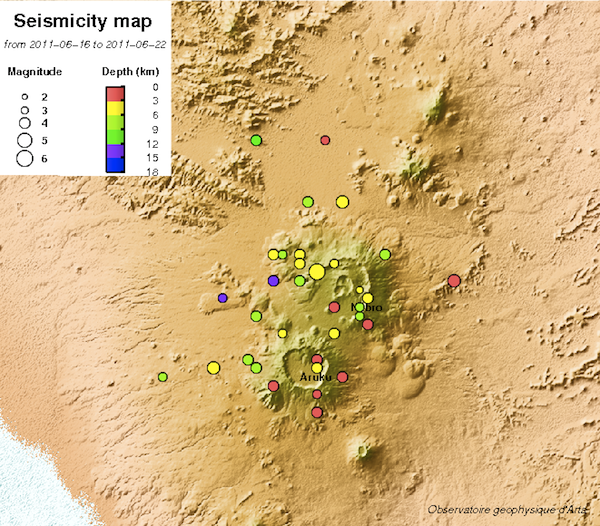
Update: via the Earthquake Report, I’ve found a local seismometer network in Djibouti, the country south of Eritrea, which has the ability to pick up smaller earthquakes associated with the Nabro eruption. According to their page commenting on the eruption, although activity really kicked off on the 12th June, there was some seismic activity in the area in May – around half a dozen approximately magnitude 2.5 earthquakes, mainly to the northwest of the Nabro caldera. They also have a more detailed map of the seismicity for the 12th June (with almost 50 events) and also a map of the last 7 days of activity. Despite the addition of many more lower magnitude earthquakes to this sequence, there doesn’t seem to be any particular trend in the location of the seismic activity.
Also, if you’re interested in the tectonic forces driving the earthquakes and volcanism in the Afar triangle, and want to learn about the latest (pre Nabro) research on the activity in this area, check out this superb article by Alex Witze.



Comments (4)
Links (3)-
-
-
Pingback: Eritrea Nabro volcano – First pictures and video from the eruption at the Eritrean side of the border
Pingback: Gdyby nie internauci nie wiedzieliby?my.Erytrea erupcja wulkanu Nabro: nowe zdj?cie satelitarne pokazuj? siln? aktywno?? + video « Zenobiusz's Blog
Pingback: Humanitarian crisis in Eritrea? The volcano no-one expected. « geologygeek