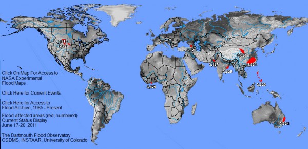
![]() Since the last edition of flooding around the world, flooding along the Mississippi River has mostly subsided, but flooding continues along the Missouri River and in China. Several new flood wetspots have also popped up, as the image below from The Flood Observatory (at the University of Colorado) depicts.
Since the last edition of flooding around the world, flooding along the Mississippi River has mostly subsided, but flooding continues along the Missouri River and in China. Several new flood wetspots have also popped up, as the image below from The Flood Observatory (at the University of Colorado) depicts.
The big stories are flooding in China, along the Missouri River, and on the Souris River in Saskatchewan and North Dakota. The best summary I’ve seen is by Jeff Masters of Weather Underground, who gets straight to the story in his headline: “Floods overwhelm North Dakota levees; floods kill 175 in China”. The Flood Observatory also has a handy table that includes flood cause, duration, and a snippet of recent news for each of the flood events pictured on the image above.
China
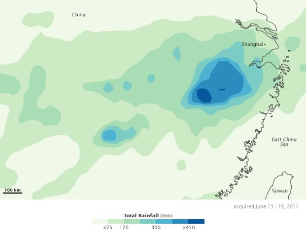
Flooding continues in central and southern China’s Zhejiang, Jiangsu, Anhui, Jiangxi, Hubei, Hunan and Guangdong provinces, and in parts of the northwest Gansu Province (though drought is still the more dominant threat there).
- What’s happened?: As of June 20 (the last time there were major overview news articles on the situation): More than 170 people dead, 5 million affected, $4.9 billion in damages, dikes barely holding, and more rain on the way (Al Jazeera, CNN)
- What’s happening right now? China prepares for more flooding: rainy season has already brought misery, but new problems are expected, including typhoons and further inundation (22 June) from Al Jazeera English; Tropical Storm Meari drenches east China (including Shangai), while drought plagues northwest (People’s Daily, 26 June) and a similar story from Bloomberg (26 June)
- Dramatic photos:In Focus at The Atlantic, the Sacramento Bee’s “The Frame”, and the International Business Times’ “Picture This.”
- The view from space: NASA’s Earth Observatory has a couple of images from flood-stricken areas in China. They’ve been plagued by cloudy weather for much of the last couple of weeks (very much related to the cause of the flooding!), but they have created an event page where you can look for updates.
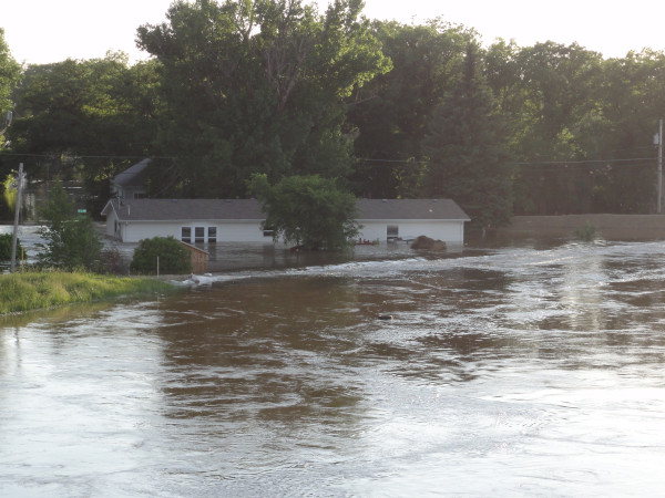
NOAA Hydrologist Steve Buan took this photo on 25 June from Broadway Bridge looking upstream in Minot, ND, via Justin Kenney on Twitpic
The Souris River and Minot, North Dakota
More than 11,000 people have been evacuated and more than 4000 homes inundated in record-breaking flooding in Minot, North Dakota and surrounding communities. Levees in Minot were over-topped, even after emergency preparations by the Corps of Engineers. The river crested yesterday about 2 m above major flood stage, but will remain extremely high for a few more days.
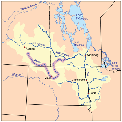
- Where is the Souris River? It is not part of the Missouri basin. No, as the map below shows, the Souris is part of the Assiniboine River River watershed. The Red River, which flooded earlier this year also drains to the Assiniboine, but the currently flooding Souris doesn’t have the same lake bottom geologic history as the Red.
- Why is there flooding?The seeds of the record floods along the Souris and Missouri Rivers were sown beginning last summer, with persistent heavy rains (that lead to flooding), a wet fall, a snowy winter, and then another very wet spring.
- What’s it like in Minot right now?The city is effectually split in half by the flooding, with 1 in 3 residents is evacuated. It is unclear whether the municipal water supply of Minot and a nearby Air Force base has been contaminated, so the city is under a boil water order. (CNN wire report, 26 June). Residents in unflooded portions of town and surrounding areas are doing what they can to shelter the evacuees and take care of the belongings they got out before the flood arrived. (AP, 26 June)
- Are there problems anywhere else on the river?Yes, the flood has displaced hundreds in southeastern Saskatchewan, upstream of North Dakota (CBC, 20 June). Floodwaters in that area are now receding (Montreal Gazette, 25 June). Downstream of North Dakota, residents along the Souris River in Manitoba are working to build up their defenses, because the flood will be there in less than two weeks. (Toronto Sun, 25 June). This new flooding arrives on top of already a record-breaking year for floods for the province, with $1 billion in damages already and 3 million acres of farmland still soaked and unplantable (UPI, 22 June).
- Are there any good pictures of the flooding?The Sacramento Bee had a striking collection of photos on Friday, 24 June. A lot of the news stories linked to above have photos, NASA’s Earth Observatory has an event page with four sets of images so far, and I’d be really surprised if the other big photo news blogs didn’t have a set of images at some point in the next few days.
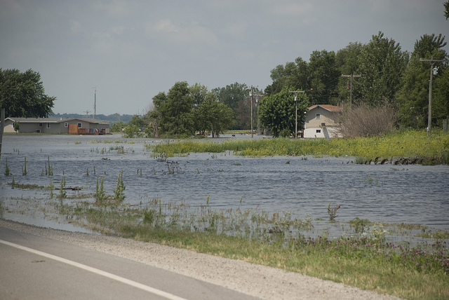
Flooding from the breach of a non-federal levee near Rulo, Nebraska on 19 June. The levee overtopped and breached on 18 June 2011, flooding U.S. Route 159 and the surrounding area. Photo by Diana Fredlund, US Army Corps of Engineers. Image from Flickr.
Missouri River
Record flooding continues to move downstream in the Missouri River system. Heavy snowpacks and a lot of rain in the Upper Missouri have forced unprecedented releases of water from the dams along the river in the Dakotas. Right now, the biggest flood problems seem to be in Missouri and Iowa, but high water and evacuated areas are stretched all along the river, and the flood won’t fully recede for months. The National Weather Service has a flooding information page set up, with regular updates.
- How has the flood been affected by the dams along the Missouri River? There’s a lot of public debate over whether the Corps of Engineers management plan for the river favors upper basin states’ desires to keep their reservoirs full over the flood-control needs of downstream states. (KC Monitor, 25 June) People are asking why the Corps didn’t release more water earlier this year, in order to prevent such massive releases now. But, flood prediction models couldn’t have forecast the week after week of heavy rain that fell this spring. Still, I expect people and politicians (especially in the lower basin) to keep talking about this as long as the flood and its cleanup lasts. Here’s an editorial from the Des Moines Register (25 June) that tries to put things in perspective.
- How are the levees? “A total of four levees in Missouri have been breached along the Missouri River, according to officials with the U.S. Army Corps of Engineers in Kansas City. The epicenter of the flooding in Missouri is located in Holt County, where two levees have been overtopped and two levees have been breached by raging water flowing down from a reservoir in South Dakota. ” (KC Monitor, 25 June) There have also been levee breaches in multiple places on the Iowa side of the river (Reuters, 25 June).
- What about the nuclear plants? Two Nebraska nuclear plants are in the path of Missouri flood waters, but emergency levees are 0.6 m higher than the expected crest at the Fort Calhoun plant (Omaha World-Herald, 17 June) and 2 m higher than the expected crest at the Cooper station (Chicago Tribune, 25 June). [Update: 6:30 pm 26 June: While I was writing this post, news wires reported than a temporary berm around the Fort Calhoun plant breached last night. Two feet of water now surround reactor buildings, but the reactor systems were unaffected and inside water-tight buildings. (Reuters)] Charmingly, residents near the plants are unconcerned, according to the Chicago Tribune story.
- What does the flood look like from above? NASA’s Earth Observatory has 9 satellite images of the flood, so far. There’s also a nice video taken on 9 June from a low-altitude airplane, by KETV news.
Open Thread
Please use the comment thread below to add links to updated news stories, videos, or imagery about any floods that are occurring in the next few weeks. I’ll write another flood update in mid-July. If there are particular floods you are interested in, or if you’d like me to delve more into the hydrological details, please let me know.



Comments (7)
Links (2)
-
-
Pingback: Flooding around the world (3 July edition) | Highly Allochthonous
Pingback: Flooding around the world (26 June edition) « Watershed Hydrogeology Blog