![]() In case other events have crowded it out of your news feed, there’s record-breaking flooding going on in the Mississippi River basin. Snowmelt in the headwaters, combined with weeks of heavy rains in the middle reaches of the river basin, have pushed the system to its engineered limits. The Mississippi River basin is home to more than 100 million people, and when the water flows past Natchez, it’s carrying flow from 41% of the contiguous United States, making it the third largest river basin in the world. The volume of water carried by the Mississippi River in flood can be measured in the same unit as ocean currents — within the next few days, the Mississippi River at Natchez will be flowing more than 2 Million cubic feet per second.
In case other events have crowded it out of your news feed, there’s record-breaking flooding going on in the Mississippi River basin. Snowmelt in the headwaters, combined with weeks of heavy rains in the middle reaches of the river basin, have pushed the system to its engineered limits. The Mississippi River basin is home to more than 100 million people, and when the water flows past Natchez, it’s carrying flow from 41% of the contiguous United States, making it the third largest river basin in the world. The volume of water carried by the Mississippi River in flood can be measured in the same unit as ocean currents — within the next few days, the Mississippi River at Natchez will be flowing more than 2 Million cubic feet per second.
Start here
For hands-down the best analysis on the flooding, the engineering, the politics, and the media coverage of the flooding, you need to turn to Steve Gough’s Riparian Rap blog. Go there now to get caught up. Then when you want some other perspective, check out the links and resources below.
General information on the flooding
- Nice zoomable map of flooding in Mississippi basin
http://online.wsj.com/article/SB10001424052748703922804576300840515646976.html#project=MIDWESTFLOODS1104&articleTabs=interactive
(via @NEMWIUpperMiss) - “Project Flood’ is upon us,” said by a Corps of Engineers hydrologist. These are words to strike fear in hearts of Mississippi River hydrologists and engineers.
http://www.nytimes.com/2011/05/02/us/02levee.html?ref=science
(via @clasticdetritus) - AP news story from Friday (6 May) on how Mississippi flooding is moving downstream
http://www.huffingtonpost.com/2011/05/06/mississippi-delta-flood-2011_n_858553.html - Current information on conditions in the New Orleans district of the Mississippi River, including information on Monday’s opening of the Bonnet Carre Spillway
http://www.mvn.usace.army.mil/bcarre/missriver.asp - This information-dense graphic shows current flows in the Lower Mississippi, relative to the "Project Flood" (max engineered)
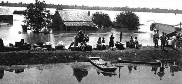
http://www.mvn.usace.army.mil/bcarre/Project-Design-Flood-Flood-Fight-08may11.pdf - National Weather Service senior hydrologist: "Compared to the Great Mississippi Flood of 1927 this flood is going to be a lot nastier," Oof.
http://www.reuters.com/article/2011/05/06/us-flooding-idUSTRE74462I20110506 - NASA Earth Observatory has been running an incredible series of images of flooding along the Mississippi and Ohio Rivers:
http://earthobservatory.nasa.gov/NaturalHazards/view.php?id=50475
http://earthobservatory.nasa.gov/NaturalHazards/view.php?id=50470
http://earthobservatory.nasa.gov/IOTD/view.php?id=50504
Floodways doing what they were designed to do
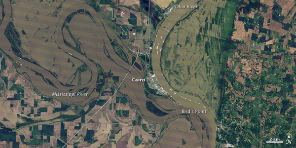
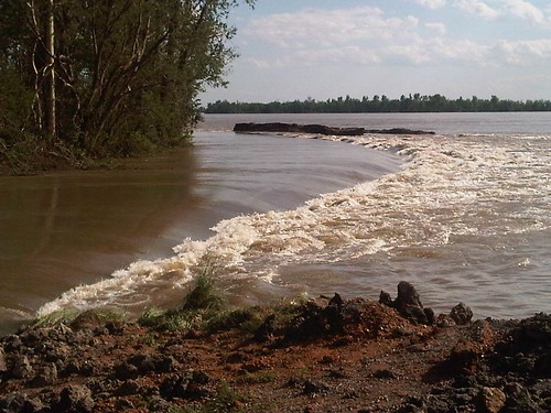
Early in the week the big Mississippi news story was on the opening of the Bird’s Point Floodway in Missouri. Media reports tended to focus on the sensationalist “us vs. them” people stories, with most of the stories completely missing the fact that the floodway was designed for this purposes and residents in it had known about and been compensated for its existence. Steve Gough had great coverage, including this piece.
The next big to-do will be over opening the Morganza floodway in Louisiana, expected to happen on Thursday 12 May. So far, the news media seems to be taking a bit more reasonable perspective here, but I expect there will be hysterical stories as well. My two cents: Based on experience with devastating past Mississippi River floods, our national policy has been to design and designate floodways to relieve pressure on levees on the mainstem of the Mississippi River. This means that some people miles from the main river will lose homes and property (and have been compensated for that risk), but it is for the benefit of much larger populations. Further, the areas that lie in floodways are part of the natural floodplain of the Mississippi River, and they would flood much more frequently without the levees.
More information on Bird’s Point and Morganza floodways can be found below.
- The science behind blowing up the Missouri levee
http://blog.nature.org/2011/04/rising-floodwaters-compel-hard-decisions/
(via @jjopperman, @Etheostomatt) - Information on USGS activities measuring flow and velocity in and around the Bird’s Point floodway
http://water.usgs.gov/osw/floods/today/BPNM_measurement.html - Brian Romans wrote a nice post on how flooding creates floodplains. Bird’s Pt Floodway in Missouri is great farmland because it floods!
http://www.wired.com/wiredscience/2011/05/flooding-creates-floodplains/ - Morganza Spillway in Louisiana may open next week to divert Mississippi River flood flows
http://www.nola.com/weather/index.ssf/2011/05/morganza_spillway_may_be_opene.html
(via @MGhydro, @americanrivers) - If Morganza Floodway on Lower Mississippi opens this week, some areas could see 5 to 25 feet of water. Here’s an inundation map:
http://www.mvn.usace.army.mil/news/view.asp?ID=461
Background Reading
The best general background information on floods and flood control on the Mississippi River can be found in John M. Barry’s book “Rising Tide: The Great Mississippi River Flood of 1927 and how it Changed America” and John McPhee’s essay on the Old River Control Structure in The Control of Nature, available on-line through The New Yorker.


Comments (5)
Links (1)-
Pingback: Flooding along the Mississippi River | Highly Allochthonous « My Blog