Based on information from The Flood Observatory and other news sources, here are some tidbits about on-going and recent flood events around the world. Every one of these floods is having significant local and regional impacts, even if they don’t make the international news circuit. Common threads amongst these floods are the impact of the La Nina climate pattern and the unequal distribution of flood risks across the economic spectrum.
New Zealand
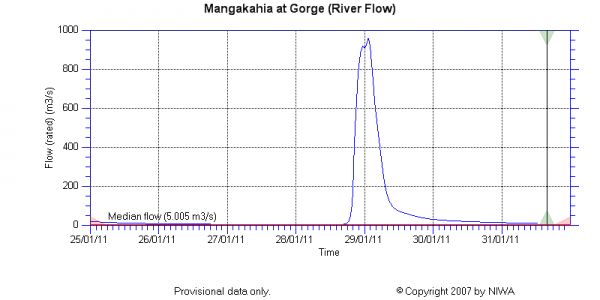
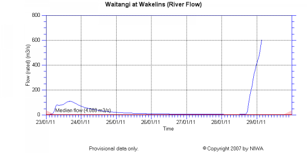
Cyclone Wilma hit the northern end of New Zealand’s North Island on Friday and Saturday 28-29 January, bringing with it intense rains, flooding, and landslides. Wilma unleashed about 28 cm of precipitation in just 12-14 hours, resulting in damage to homes, roads, and water and sewer treatment infrastructure. This was the fourth tropical low to impact New Zealand in just three weeks. The New Zealand Herald has a nice collection of reader-submitted images showing flooding and damage in various areas. My particular favorites are this flooded river valley and this road closed by a landslide. The New Zealand National Institute of Water and Atmospheric Research (NIWA) provides near real-time hydrologic, sea level, and climatic data through their Environmental Data Explorer, so I can show you quantitatively what this cyclone meant for a couple of rivers.
While the graphs above show discharge (flow volume per time), which is the unit of currency for hydrologists who want to compare multiple rivers to each other, local flooding impacts depend also on the depth(or stage) of the water. For reference, the Waitangi River goes from ~0.4 m before the storm to 6.2 m at the end of the record shown above. If you click through to this image on the New Zealand Herald website, you’ll see why the record for the Waitangi River ends when it does. That gaging station wasn’t meant for those flow conditions.
Australia
While Queensland begins to tally its losses and recover from massive flooding earlier this month, tropical cyclones aren’t about to make the job any easier. Cyclone Anthony brought mostly heavy winds to the Queensland coast south of Townsville Sunday night, and damage is reported to be minimal. But much bigger and much stronger Cyclone Yasi is expected to make landfall in the same area as a Category 4 storm later this week. This cyclone is expected to produce widespread, heavy rain, a strong storm surge along the coast, and winds up to 260 km per hour.
Meanwhile, in the southeastern state of Victoria, tributaries to the Murray River are also flooding. These floodwaters are still rising and are expected to take weeks to months to recede. Increasing my sympathy for the Australians, Victoria and South Australia are also experiencing a ridiculous heat wave, with temperatures reaching or exceeding 40 C for several days in a row.
Saudia Arabia
Flooding occurred around the city of Jeddah over the weekend, killing at least 10 people. Three hours of rain produced 11 cm of precipitation, cars were washed away, and the video below shows the failure of a dam, which the videographer says contained a lake used for dumping untreated sewage.
South Africa
Flooding in South Africa has gotten almost no international attention, despite the fact that floods have killed 120 people there and have caused disaster declarations in 8 of 9 provinces. Flooding has also affected Mozambique, where 13 people have died, and forecasts for continued heavy rains over the next several months have much of the southern part of the continent on alert. In some areas, up to 10 times as much rain as normal has fallen in the month of January. Tens of thousands of homes have been destroyed. Many of the lost homes are shacks belonging to poor Africans, because informal settlements are often located in low lying areas.
Brazil
The clouds have cleared over the area around Rio that was hard-hit by floods and landsliding earlier this month. The death toll now exceeds 840 people, and the Brazilian federal and state governments have promised to provide up to 8000 homes for people that lost theirs in the disaster. The government also plans to immediately begin increasing its disaster preparedness, including mapping of high risk areas and better weather data collection. Dave Petley did a great analysis using before and after aerial imagery in one of the slide-affected area.


Comments (2)
Links (2)-
-
Pingback: In natural disasters, it’s the poor who suffer : jfleck at inkstain
Pingback: Flooding around the world « Watershed Hydrogeology Blog