![]()
![]() The question of whether the Darfield earthquake was a ‘surprise’ depends greatly on how you look at it. The fact that Christchurch was shaken up by an earthquake was not a surprise at all, given that New Zealand is neatly bisected by a plate boundary.
The question of whether the Darfield earthquake was a ‘surprise’ depends greatly on how you look at it. The fact that Christchurch was shaken up by an earthquake was not a surprise at all, given that New Zealand is neatly bisected by a plate boundary.
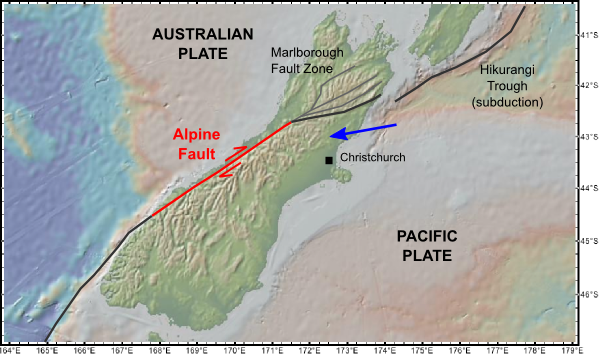
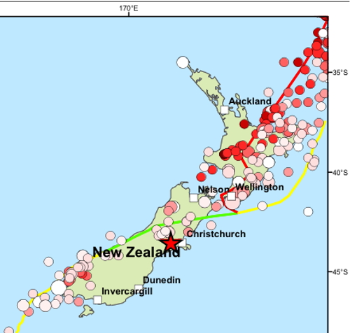
The Pacific-Australian plate boundary on the South Island of New Zealand.
However, the precise location of the earthquake on 3rd September was perhaps a bit more surprising, given that the most obvious manifestation of the plate boundary on the South Island is not on the Canterbury Plains, but in the western foothills of the Southern Alps. Just like the Tetons, the steep western face of this range is effectively the scarp formed by several million years’ worth of motion on the Alpine Fault, and the 20 km or so of vertical motion pales in comparison to the several hundred kilometres of lateral motion between the Australian and Pacific plates that has been accommodated on this structure in the last 30 million years or so.
Despite its obvious tectonic significance, the Alpine fault has not ruptured since European settlement in the 1840s. In fact, it’s quite the opposite: a map of all significant earthquakes in the past couple of centuries reveals a notable lack of seismic activity compared to the rest of the plate boundary region.
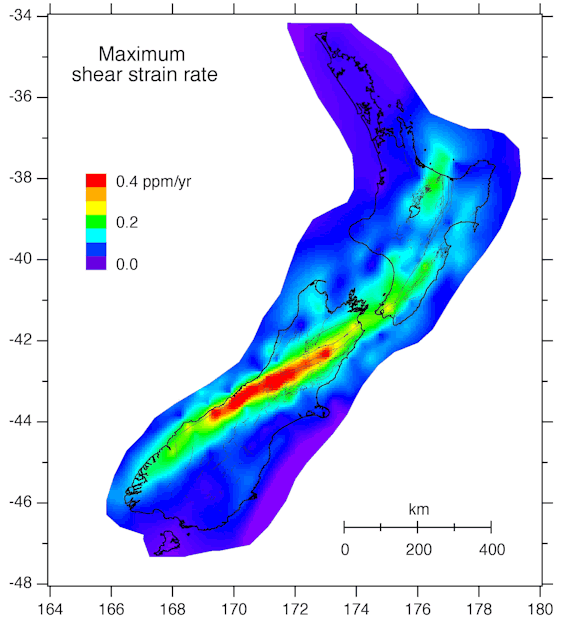
However, GPS measurements of present day deformation show that a large amount of elastic strain is constantly building up on the eastern side of the Alpine Fault, which will eventually have to be released by a rupture of the fault. The only question is, when?
The lack of a historical record for the Alpine Fault means that we must instead examine the geological record left by past ruptures. The most direct way to do this is by digging a trench across the fault zone itself, and carbon dating organic rich sediment layers that have been disrupted as the fault breaks through to the surface – a displaced layer provides a maximum age for the earthquake (it must have occurred after the sediment was deposited); an undisturbed layer draping across a scarp provides a minimum age. However, this is not the only effect of a large earthquake in a steep, mountainous region like the Southern Alps. It will also trigger landslides, which not only reshape the landscape in their own right, but dump huge amounts of sediment into the rivers running down from the mountains. As soon as the rivers reach level ground and slow, much of this sediment will be deposited, causing the river to build upwards – a process known as aggradation. But some of the excess sediment does make it all the way to the coast, causing the shoreline to prograde – grow outwards – around the river mouth.
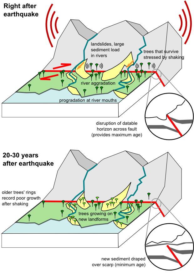
How past earthquakes leave their mark on the landscape and vegetation.
The important thing is that all of these new landforms can be dated. Ages can not only be estimated from carbon dating of the sediments directly beneath aggradation and progradation surfaces, but also by dating the trees growing on top of them. An earthquake on the Alpine Fault sweeps away old forest and creates large tracts of clear ground for new vegetation to spring up upon. Tree ages in this entire region are therefore clustered around the times of major earthquakes. Even the trees that have survived an earthquake will bear the scars of the shaking, in the form of periods of poor growth recorded in their rings.
By combining all of these sources, New Zealand geologists have been able to piece together the timing of earthquakes on the Alpine Fault. A 2007 paper by Andrew Wells and James Goff further refined previous studies by looking in detail at the ages of coastal landforms, and provides the most up to date summary of the paleoseismic record. There appear to have been six distinct episodes of shaking in the last 1000 years, with estimated dates of 1230, 1410 and 1500 (older studies appear to have combined these two into one episode with an estimated date of 1460), 1615, 1717 and 1826. Four of these episodes – 1230, 1410, 1615 and 1717 – have been identified in trenching studies, so are definitely due to ruptures of the Alpine Fault. Furthermore, trench ruptures, landslides, and new fluvial and coastal landforms associated with these earthquakes are found all along the Alpine fault, suggesting that a substantial length – 3 or 4 hundred kilometres – of the whole active structure ruptured in one go, generating a magnitude 8+ earthquake. The other two shaking episodes in 1500 and 1826 only seem to have affected the southern part of the Southern Alps, and no evidence of a rupture has yet been found in trenching studies; this suggests that they may be due to earthquakes on the adjacent Puysegur subduction zone on the Fjordland coast. From these data, the average repeat time of the four confirmed ruptures of the Alpine Fault is around 160 years, and the maximum gap between ruptures is about 200 years. The last confirmed rupture, in 1717, was almost 290 years ago. The math is hardly reassuring, is it?
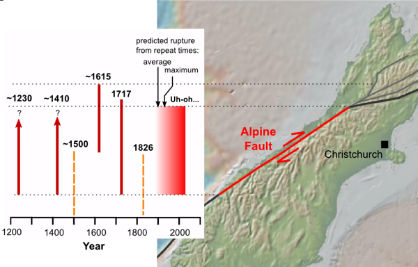
Past ruptures on the Alpine Fault (red lines) as estimated from paleoseismological studies. Both the average and maximum known recurrence interval were passed in the first half of the 19th century. The orange dashed lines denote events that probably occurred on the subduction zone to the south.
Note that I have refrained from using words like ‘overdue’. Whilst it’s certainly true that we are currently at the wrong end of the longest known period between ruptures on the Alpine Fault, we need to bear in mind that from a geological perspective, our record is still woefully short – there is no way of knowing if the last millennium accurately reflects the long-term seismic behaviour of the fault. There could be periods of activity separated by longer periods of relative quiescence, for example. That said, from what we do know, there will be a large earthquake on the Alpine fault in the not-too-distant geological future, and it would be no surprise if it happened tomorrow. It would also be no particular surprise if it didn’t happen for another 50 years; unlike we impatient humans, a fault would hardly know the difference.
As for the impact of such an event on New Zealand: well, Christchurch would certainly get shaken up, but perhaps not much more than it was a couple of weeks ago, due to the greater distance from the Alpine Fault. Settlements on the west coast like Greymouth and Hokitika would be far more severely affected; roads and railways across and along the Southern Alps could be destroyed; and there must be some risk of damage to some of New Zealand’s many hydroelectric dams, which are a significant contributor to the country’s overall generation capacity. Fortunately, as the past couple of weeks have shown us, the Kiwis are neither ignorant of these risks, nor unprepared for them.
Wells, A., & Goff, J. (2007). Coastal dunes in Westland, New Zealand, provide a record of paleoseismic activity on the Alpine fault Geology, 35 (8) DOI: 10.1130/G23554A.1



Comments (21)
Links (7)
-
-
-
-
-
-
-
Pingback: Open Laboratory 2010 – submissions so far | A Blog Around The Clock
Pingback: Open Laboratory 2010 – three weeks to go! | A Blog Around The Clock
Pingback: Open Laboratory 2010 – two weeks to go! | A Blog Around The Clock
Pingback: Open Laboratory 2010 – only eight days till the deadline! | A Blog Around The Clock
Pingback: Open Laboratory 2010 – the final stretch! | A Blog Around The Clock
Pingback: Open Laboratory 2010 – submissions now closed – see all the entries | A Blog Around The Clock
Pingback: After the (blog)storm: following up on the big geological stories of 2010 | Highly Allochthonous