One of the more interesting announcements to come out of the AGU Meeting of the Americas this week requires us to take another look at the magnitude 7 earthquake that devastated Haiti 8 months ago, because it appears the tectonic picture might be a little more complicated than we originally thought.

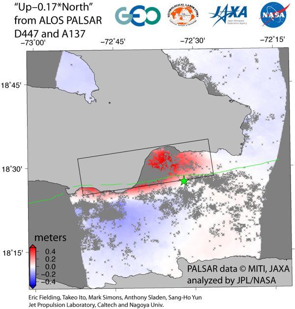
As I stated at the time, this focal mechanism shows mainly strike-slip deformation, which is exactly what you would predict from Haiti’s position right on top of a transform plate boundary. However, we are not seeming pure strike-slip here: the way that the nodal planes (the lines separating the red and white bits of the beachball) are tilted away from the vertical (they are curved, rather than straight) tells us that there is also some convergence being accommodated by this earthquake. In tectonic parlance, this is known as transpression, and means that while the crust is mostly sliding past each other as the fault ruptures, there is also some uplift of one side of the fault relative to the other. Such vertical motions can be quite easily measured using radar interferometry: the plot below, courtesy of Eric Fielding, shows the change in ground height, as measured by satellite radar altimetry, caused by the January 12 rupture.

Uplift (red) and subsidence (blue) due to the magnitude 7 12th January 2010 earthquake in Haiti (star=epicentre). The green line marks the location of the Eniquillo Fault. Image: Eric Fielding
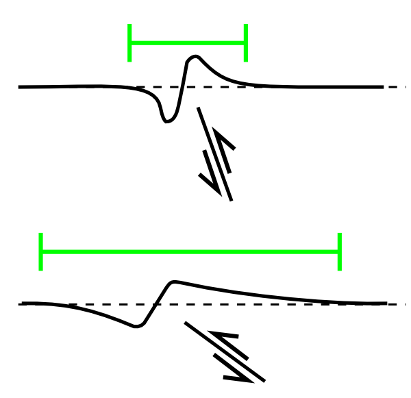
There are two important things to notice about this figure. First, there is a sharply defined pattern of uplift to the north, and subsidence to the south, with very little grading between them. This is just what you would expect from thrust deformation on a roughly E-W oriented fault; however, the transition from uplift to subsidence does not follow the trace of the Enriquillo Fault, which until now was thought to be the fault that ruptured during January’s earthquake. The figure shows that the earthquake caused uplift some distance south of the Enriquillo fault, as well as to the north of it, which suggests that displacement did not occur across it. The other thing to notice is that the region affected by uplift or subsidence extends some distance to the north and south of the epicentre. A broad area of uplift or deformation is caused by motion on a fault that has a relatively shallow dip; for deeply dipping faults, the uplift and subsidence is confined to a much narrower region close to where the fault breaks the surface. Rather damningly, it turns out that the Enriquillo Fault is quite steeply dipping.

Comparison of area affected by vertical displacement for a steeply dipping fault (top) and a more shallowly dipping fault (bottom)
In short, the deformation pattern caused by the January 12 earthquake is not consistent with it occurring on the Enriquillo Fault. If you try to model the type of fault that best reproduces the observed vertical deformation (the black rectangle in the second figure above), you get a rupture surface that dips to the north, and possibly cuts through the Enriquillo Fault at some point beneath the surface. As Eric Calais explains in a video up at the AGU Meetings blog, this new fault has provisionally been named the Leogane fault, after the town found in the middle of the uplifted region.
And it might be even more complicated still: the strike slip motion indicated in the focal mechanism above might have mainly occurred on another fault, also distinct from the Enriquillo Fault, in the same area, that ruptured at the same time. This complexity might partially explain why it was not immediately obvious that the Enriquillo Fault was not the prime mover in January’s earthquake; if the earthquake waves being received at distant seismic stations were produced by more than one rupture, the calculated focal mechanism would be a composite, mixing up the information from two separate events and thus describing neither accurately.
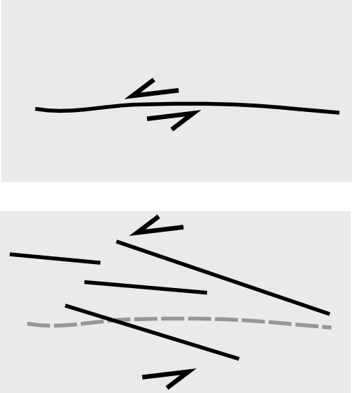
What these new observations appear to be telling us is that we are looking at another case of distributed deformation across a plate boundary. Rather than one or two big structures such as the Enriquillo Fault accommodating the motion between the North American and Caribbean plates, this motion is being absorbed by a whole group of faults, which may have even ‘taken over’ from the larger structures.

Rather than all the inter-plate motion being accommodated on one large structure such as the Enriquillo Fault (top), several faults, distributed over a much wider area (bottom), might be involved.
On a regional level, this has no particular significance; the same amount of strain will build across the plate boundary region as a result of plate motions; the same 40 km section of the plate boundary west of the epicentre released a large amount of its accumulated strain in January’s earthquake; the same 20 km section to the east has still not ruptured in more than 250 years, which is of significant concern due to its proximity to Port-au-Prince. However, because a number of faults seem to be involved in accommodating plate motions, the seismic hazard can no longer be localized to one big structure, making it much more difficult to work out which areas are relatively safe and which are not. Complex interactions between all the different faults as they rupture and cause local stress changes also make it difficult to estimate how much additional loading might have been placed on faults in the unruptured region to the east, making the likelihood of a rupture there in the not-to-distant future much harder to calculate. In other words, the sort of information that Haitians need as they start to rebuild their countries infrastructure – how much shaking they need to proof their buildings against when building in a particular location, and how frequently it will occur – is going to require a lot more detailed work than we thought it would.
(Thanks to Eric Fielding for providing a great deal of useful background on these new findings via e-mail.)


Comments (3)
Links (3)-
-
-
Pingback: Friday(ish) Focal Mechanisms: Samoa’s hidden rupture | Highly Allochthonous
Pingback: Another point source in the geoblogosphere | Point Source
Pingback: Il terremoto di Haiti innescato dalla deforestazione e dagli uragani? | Climate Monitor