![]() For the past two weeks, unusually heavy monsoon rains have deluged Pakistan, resulting in flooding and landslides. Pakistan is heavily populated all along the Indus River valley, so this is a slow-moving disaster of epic proportions. The latest news reports estimate that flooding has displaced 14 million people – more than the number of people affected by the 2010 Haiti earthquake, 2005 Kashmir earthquake, and 2004 Indian Ocean tsunami combined.
For the past two weeks, unusually heavy monsoon rains have deluged Pakistan, resulting in flooding and landslides. Pakistan is heavily populated all along the Indus River valley, so this is a slow-moving disaster of epic proportions. The latest news reports estimate that flooding has displaced 14 million people – more than the number of people affected by the 2010 Haiti earthquake, 2005 Kashmir earthquake, and 2004 Indian Ocean tsunami combined.
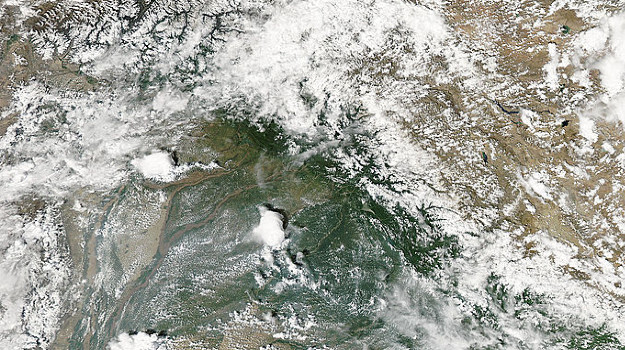
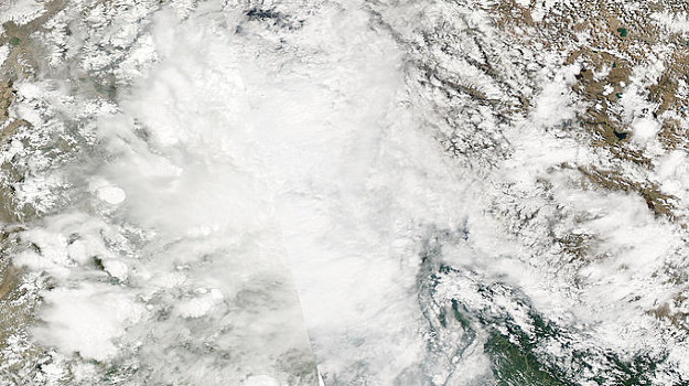
In the first 10 days of August, parts of Pakistan received almost 24 mm per day more rainfall than usual – during what is usually the wettest part of the year, when the monsoon rains fall. During June-September, the relatively cool Indian Ocean has high atmospheric pressure system, while the intense summer sun heats up the Indian subcontinent and forms a low pressure system. Much like a river flows downhill, air in the atmosphere flows from high pressure to low pressure areas. So moisture rich air from the ocean flows toward India and Pakistan – bringing months of cloudy weather and intense rain. The images below are from true color images from NASA’s MODIS satellite showing the Indus and Chenab rivers in the area around Islamabad. The top image shows the clearest day from recent weeks (9 August), while the bottom image shows a more typical day (6 August).
This year, the monsoon precipitation has been especially intense in Pakistan, because the jet stream is experiencing a blocking event – when the normal eastward progression of weather patterns in the midlatitudes gets stalled out and you get the same weather for weeks on end. This created an additional low pressure zone over Pakistan’s northern mountains, bringing even more moisture to the headwaters of the Indus River. The rain also seems to be exacerbating the landslide and landslide dam problems in the region of the Hunza River, a tributary to the Indus in the northern mountains. (Update: Jeff Masters has a nice explanation of this jet stream blocking event and how it links the Russian heat wave and Pakistan floods.)
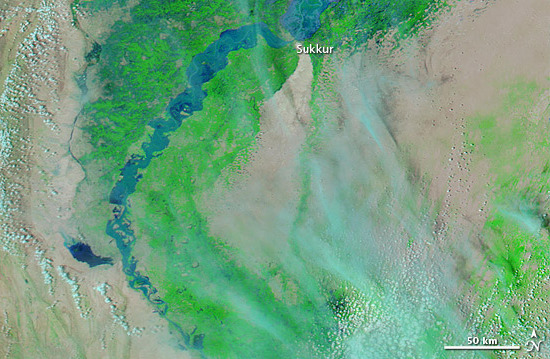
Flooding on the Indus is not an instantaneous disaster – it is one that will continue to occur for weeks, with consequences that last years. Because the flooding is being caused by prolonged intense precipitation, there can be multiple flood peaks – where the water level crests, starts to fall, and then rises again. There are already two flood peaks moving downstream, and if further rain falls, there may be three peaks to the flooding, and it could last through the end of August. Also, since much of the rain has fallen in the north, closer to the headwaters of the Indus, the flooding began in the north, and the flood waves are transmitted downstream over a matter of days to weeks. While river levels are now slowly declining in the north, the first flood peak is just reaching Hyderabad – the largest city along the river, with a population of 1.5 million. How fast the flood moves downstream depends on the storage properties of the channel and floodplain. There is some possibility that if the first flood peak stalls out in an area with lots of floodplain storage or obstruction of flow by debris-choked bridges, the second flood peak could catch up, creating an even larger disaster. NASA has a series of wonderful images showing the flood progressing downstream from Sukkur, north of Hyderabad, from 8 -12 August. The latest image is shown below.

Flooding on lower Indus River, 12 August 2010 (NASA MODIS image, combination of infrared and visible light)
Even when the final flood peak reaches the ocean and the Indus River returns to its banks all along its course, the human disaster will continue to unfold. 14 million people have been displaced by this flood – and those people may have lost everything they own. Beyond the personal losses, there has been devastation to infrastructure such as roads and bridges, complicating relief efforts and even making access to some areas nearly impossible. The Indus is the source of water for irrigation canals throughout Pakistan and damage to them is likely to be intense, especially near the river, so agricultural productivity will suffer even in areas that escaped inundation. Village wells will have been contaminated by floodwaters, so access to safe drinking water will be an issue for months.
That’s a lot for any nation to handle – 1 in 12 residents directly affected by the flood – but for Pakistan’s already fragile national government it will be an especially difficult challenge. As the flooding has unfolded, Pakistan’s government has appeared less equipped to provide immediate relief to flood victims than Islamist charities, which will probably increase their support as they fill empty stomachs and provide shelter. There are other aid groups working to ameliorate the suffering. Two of my favorites are MercyCorps, providing clean water, food, and clean up tools in the Swat Valley, and Medecins Sans Frontiers/Doctors Without Borders, which is providing sanitation kits and basic supplies in Kyber Pakhtunkhwa and Baluchistan. Dave Petley, who has worked in Pakistan, recommends FOCUS Humanitarian Assistance.


Comments (2)
Links (6)-
-
-
-
-
-
Pingback: Stuff we linked to on Twitter last week |
Pingback: Another point source in the geoblogosphere | Point Source
Pingback: After the (blog)storm: following up on the big geological stories of 2010 | Highly Allochthonous
Pingback: A flood is a disaster when people are in the way | Highly Allochthonous
Pingback: Landslides and flooding in Brazil | Highly Allochthonous
Pingback: Pakistan floods: Predictable or predicted, but a disaster nonetheless | Highly Allochthonous